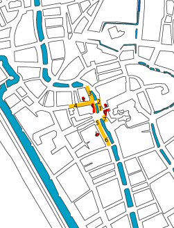
(left) Figure 55: Location of Utrecht's economic spaces in AD 1200
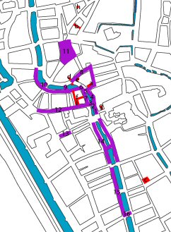
(right) Figure 56: Location of Utrecht's economic spaces in AD 1400
The previous section on Utrecht's development as a whole has already illustrated the strong correlation between integration and choice patterns and those areas with the most movement, which, especially in a town centre, most logically also correlate with those areas with retail space.
It is mainly as a result of Utrecht's development, as an agglomeration of smaller settlements, that for a long time it never had a market square as such. Utrecht originated as a burgh, which soon became a cathedral precinct. Around this area smaller settlements were established, usually around a parish church, in which case for a long time the churchyard (graveyard) served as a central market place. However, the bishop wanted to control most of the trade and therefore most of the trade was conducted on his doorstep along the Oudegracht. When the need for more market space grew, this developed along the Oudegracht and into the streets of the trading post, Stathe. Apart from a obligation to trade at the Bishop's doorstep it was also a sensible place, in particular for bulk merchandise, since it was close to the waterways where the goods were loaded and unloaded. It is therefore not surprising that the market spaces grew along the main waterway into the town. However, a distinction has to be made between the annual market, which almost always took place in Stathe, and the weekly markets, which spread from the Oudegracht into the Stathe and along the Ganzenmarkt to the Neude. Details of which markets were located where can be seen on the plans based on those by Van Vliet (1995, 27 and 36).
(left) Figure 55: Location of Utrecht's economic spaces in AD 1200
(right) Figure 56: Location of Utrecht's economic spaces in AD 1400
Comparing the actual evidence of market spaces with the integration patterns, the resemblance is striking. Therefore, it can be concluded that already in the medieval town of Utrecht market spaces were the most integrated spaces in the town and were located at the centre of urban life. In the plans of 1300 and 1550 the main focus of the integration patterns is the area just outside the burgh, in the corners of the Oudegracht, and around 1550 also the Neude, which had by that time become the central place for selling livestock. By 1846 the integration pattern had developed westwards towards the area of the former Vredenburg castle. By 2005 this expansion is even greater, as by then the area of the former castle had become Utrecht's marketplace.
As a result of this strong correlation between the archaeological and historical evidence of market space and the integration and choice values, I propose that space syntax can be used as an objective form of analysis of such economic spaces. Since the integration and choice patterns correlate closely, space syntax can also be used in locating market spaces in those cases where archaeological and/or historical evidence is slim.
© Internet Archaeology / Author
URL: http://intarch.ac.uk/journal/issue21/5/4_2.html
Last updated: Wed Aug 8 2007