![Figure 2: Image of the Bathymetry (topography) of the North Sea area. The 6250 km2 covered in this paper is marked by the position of the red box. (ETOPO2 v.2 bathymetric dataset provided, courtesy of NOAA [National Geophysical Data Centre].)](images/thumbs/figure_2.jpg)
Figure 2: Image of the Bathymetry (topography) of the North Sea area. The 6250 km2 covered in this paper is marked by the position of the red box. (ETOPO2 v.2 bathymetric dataset provided, courtesy of NOAA [National Geophysical Data Centre].)
Figure 2: Image of the Bathymetry (topography) of the North Sea area. The 6250 km2 covered in this paper is marked by the position of the red box. (ETOPO2 v.2 bathymetric dataset provided, courtesy of NOAA [National Geophysical Data Centre].)
In order to appreciate the scale and significance of research within the North Sea it is important to understand something about its geomorphology. The Southern North Sea is a marine basin that occupies a position between the European countries of Norway, Denmark, Germany, The Netherlands, Belgium, France and the United Kingdom, and is confined in latitude between 55 degrees north and 51 degrees north. The North Sea region covers some 574,980 sq km, although the results presented here relate to an area located in the Southern Sector covering 6250 km2 or approximately 1%) of the area (Figure 2). Water depths within the North Sea range from 15m at the Dogger Bank to 600m in the north. Within the area under discussion the water depths range from 20m in the northern part to 80m in the parts of the southern region.
This landscape of this region owes its appearance in part to Late Pleistocene glacial erosion and deposition. Considerable areas are underlain by a series of Late Weichselian formations that are broadly contemporaneous and reflect the different depositional environments experienced during that period of glaciation (Cameron et al. 1992) . Overlying these older deposits, the Botley Cut Formation is of Late Weichselian age to Earliest Holocene age (Figure 3). This deposit represents the infill of a series of subglacial valleys. The valleys incise Weichselian and older deposits and are filled by deposits from glaciolacustrine and glaciomarine environments. (Figure 3; Laraminie, 1989b; Cameron et al., 1992).
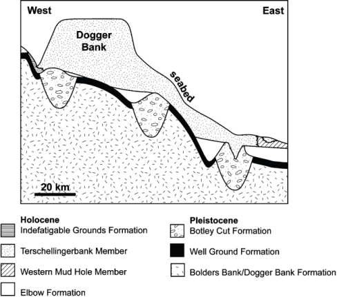
Figure 3: Simplified cross-section (not to scale) of the stratigraphy of the Pleistocene and Holocene of the Dogger Bank area. Adapted from Laraminie (1989a, 1989b).
Whilst the terminal glacial deposits form the backbone of the geology within this region, later Holocene erosion and deposition has been significant. Holocene sediments generally attaining a thickness of 1 to 5 m within this region, although locally significant deposits can reach thicknesses of up to 30m (Laraminie 1989a). These Holocene deposits record the marine transgression of the emergent landscape of the Southern North Sea. A number of peat samples have been recovered from the North Sea (see Ward et al. 2006 for a review), most of which suggest that the Dogger Bank region was emergent at 9500BP (Behre and Menke 1979), but was experiencing fully marine conditions by approximately 7500BP (Jelgersma 1979). The early Holocene Elbow Formation (Figure 3) is of primary significance to archaeology and consists of a basal clay layer and locally a basal peat. Palynological dates from these deposits are in the range of 9,900BP to 9,000BP (Behre and Menke 1979). These deposits therefore are of prime importance as they are likely to contain records of the human occupation within this region. The start of the marine transgression of the landscape is also recorded with the presence of brackish-marine and tidal flat deposits (Oele 1969) which also offer the potential of recording the human utilisation of such environments. The overlying Terschellingerbank member and the Indefatigable Grounds Formation (Figure 3) represent the products of more recent marine processes and form a thin veneer over the area (Laraminie 1989a).
Whilst the Elbow Formation deposits offer the potential to contain sites of archaeological interest, we actually have little in situ archaeology from the area. Human artefacts and mammal remains have been have been dredged from the Dogger Bank and it is been assumed that the finds have been retrieved from the seabed (Flemming 2002, 33). However, as many of these stray finds lack both dates and provenance they add relatively little to our understanding of the Mesolithic beyond that of chance finds. Those that possess such information provide an invaluable landscape record demonstrating the presence of humans, wild boar and red deer from 9,870 +/-70 BP till at least 8350 +/- 50 BP (Glimmerveen et al. 2004). Flemming (2002, 33) has suggested that suitable environments for the preservation of archaeological materials might include the Holocene fluvial valleys and vast lagoon which must have existed to the south of Dogger Bank at 8,000BP.This is supported by Kooijmans (1971) who observes the extensive peat deposits that occur at these locations. Further evidence of the importance of this area can be provided by finds of tree stumps near to a filled in river valley located to the east of Dogger Bank (Hansen 1981).
The c. 2,300 Marine prehistoric sites located around Denmark (Fischer 2004, 25, Figure 3.3) also provide valuable evidence, although most of these sites are less than 5km from the shoreline and are a significant distance from the study area. As a consequence, whilst it can be demonstrated that areas containing palaeoenvironmental evidence do survive within the North Sea these, like so much of the marine environment, remain to be explored archaeologically. Many of these areas are however, associated with extensive commercial geophysical datasets which offer a valuable opportunity to explore the region and enhance our knowledge of the area and its archaeology. Indeed, the use of such data is the only viable option to provide data for archaeological research or environmental and heritage management at a regional scale (Flemming 2002, 43; 2006, 45).
© Internet Archaeology
URL: http://intarch.ac.uk/journal/issue22/3/background.html
Last updated: Tues Oct 2 2007