In considering the significance of the work currently being carried out at Birmingham it is worth emphasising the scale of land lost during the last 12,000 years (see Figure 5). At this level the data provided from the Southern North Sea is not unique. The availability of industrial seismic data for research, however, provides a unique opportunity to gain an understanding of the prehistoric heritage of this area. Certainly, the sample interpretation provided above represents a very small area of the data either currently being interpreted by the team at Birmingham or potentially available for research. The benefits of such an approach should be obvious. The application of seismic data techniques permits us to explore the geomorphology and archaeology of the area from a substantive and practical base thus avoiding the necessity of speculative summaries required by earlier studies (e.g. Coles 1998).
Figure 5: Map illustrating the emergent parts of the continental shelves worldwide during the last glacial maximum. The figure assumes a glacial eustatic lowstand of 120m below present sea level (Fairbanks, 1989) and does not take into account glacially induced flexural uplift in high-latitude regions adjacent to large ice sheets or neotectonic (Holocene) uplift or subsidence. (ETOPO2 v.2 bathymetric dataset provided, courtesy of NOAA [National Geophysical Data Centre].)
An example of potential errors resulting from the lack of evidence for the North Sea is the frequency that the area has been referred to as a "landbridge" (Jacobi 1976, 73, Morrison 1980, 102) and the underlying assumption that the intervening area was unsuitable for habitation and even "very wet and marshy" (Wymer 1994: 13). Such a position is hardly tenable in the light of the seismic study which, in fact supports the earlier position of Coles (1998, 75) who considered the area a diverse and interesting place to live in, providing a variety of valuable biological and mineral resources (Clarke 1978, 23).
This fundamental shift in viewpoint has important implications for the archaeology of the early Mesolithic, especially as this area is so often absent from "terrestrial" interpretations (Bailey 2004, 5). Implications that may derive from this include a reconsideration of the significance of early Mesolithic coastlines (Mellars 1974, 80, Wickham-Jones 2005: 33). Those who have speculated on this subject have long regarded the coastline as a prime area for Mesolithic occupation (Morrison 1980, 118, Coles 1998, 74). It has been argued that these locales would have supported higher population densities (Coles 1998, 74) but there are questions as to why we do not see more evidence for the utilisation of coastal resources within the early Mesolithic isotopic record (e.g. Barton and Roberts 2004, 353).
From the seismic evidence it is apparent that early Mesolithic coastlines, for England at least, would have been situated some distance from the majority of the present coastline (see Figure 6). This lack of evidence is not perhaps surprising given the extent that current conditions significantly reduce accessibility and material recovery, The isotopic evidence from a human cranium trawled from the North Hinder Bank has also prompted some dispute over the value of marine resources in the North Sea region (Barton and Roberts 2004, 348). However, given the date of the sample, 9,640+/-400BP, it may be more significant to note that the find is as far from the original coast as Mesolithic sites situated on dry land today (UtC-10063; Erbrink and Tacoma 1997). The terrestrial isotopic signature of this find is therefore not anomalous. In contrast, in those few areas where the early Mesolithic coastline is extant the utilisation of marine resources during this period is apparent (e.g Nordqvist 1995).
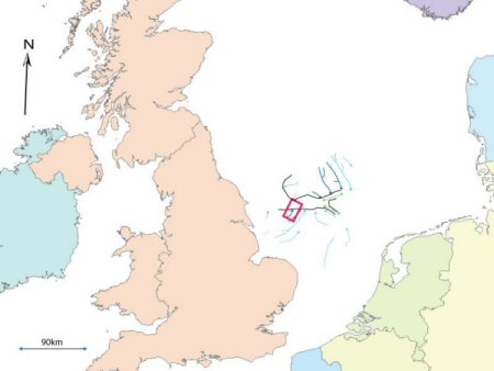
Figure 6: Schematic illustration of the main topographic features of the Holocene Landscape of the area. The area in this paper is contained within the red box. Other fluvial features (light blue) and intertidal currents (green) represent schematically preliminary results of the North Sea Palaeolandscapes Project. Discoveries made during the course of the thesis study are in dark blue. The approximate location of the coastlines observed within the seismic data are marked on in black lines. (ETOPO2 v.2 bathymetric dataset provided, courtesy of NOAA [National Geophysical Data Centre].)
It is possible to take this argument further. The evidence may be better interpreted to suggest that the marine potential of the coast encouraged hunter gathers to congregate along the coastline (Nordqvist 1995), rather than to engage in seasonal movements inland (e.g. Rowley-Conwy 1987, 76). Information from the Scandinavian coastline suggests that resource utilisation within a maritime zone was favoured (Indrelid 1978, 169-70, Nygaard 1990, 232), and it is possible that the contemporary occupants of the "Doggerland" coastline followed a similar lifestyle. Indeed it is entirely possible that the occupants of the North Sea coastline perceived inland areas as marginal (Morrison 1980, 118) and that the potential of the interior for settlement was limited and intermittent. This mode of occupation might even have denied interior groups access to coastal resources: although the possibility of some form of trade seems likely. If correct, we should not expect significant evidence for utilisation of marine resources during the early Mesolithic in the present terrestrial record. Instead, we would have to look beyond the current shoreline and to the submerged coastal landscapes of the Southern North Sea, to resolve such questions.
If this is the case, future research agendas must identify appropriate methodologies that allow us to integrate substantive data from those areas which have been inundated. This critical change will allow the development our understanding of the terrestrial archaeological record. Current methodologies for locating/predicting sites that may be investigated using existing technologies tend to be restricted in scope and without the potential for operating at the regional level (Fischer 1995). Only models based on remote sensing at various scales are likely to produce information that can be used across the whole of the region.
![Figure 5 - Map illustrating the emergent parts of the continental shelves worldwide during the last glacial maximum. The figure assumes a glacial eustatic lowstand of 120m below present sea level (Fairbanks, 1989) and does not take into account glacially induced flexural uplift in high-latitude regions adjacent to large ice sheets or neotectonic (Holocene) uplift or subsidence. (ETOPO2 v.2 bathymetric dataset provided, courtesy of NOAA [National Geophysical Data Centre].)](images/figure_5.gif)