Figure 3: Multi-technique visibility analysis
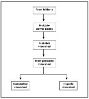
A protocol that combines a number of visibility analyses is explored in an attempt to mitigate some of the inaccuracy problems inherent in the binary viewshed and, thus, achieve more robust archaeological interpretations as regards visual control of the landscape from hillforts. In summary, for each hillfort, a set of viewpoints has been used in the generation of a probable viewshed, which, taking into account DEM inaccuracy, represents visible areas according to their likelihood of actually being in view (Fisher 1991, 1992, 1993 and 1994). The most probable visible areas have been selected and employed as input to carry out Higuchi (Wheatley and Gillings 2002, 15-20) and cumulative viewsheds (Wheatley 1995). The former is intended to show which regions might have been clearly and consistently visible and which could not have been effectively controlled. By adding together the most probable viewsheds of all the hillforts into a cumulative product, the organisation of visual control of this landscape can be explored.
The overall process is summarised in Figure 3 and further illustrated by the set of four viewsheds presented for every hillfort (Figures 16-47). In sections 3.1, 3.2, 3.3 and 3.4, each of the various techniques employed will be discussed in detail.
Figure 3: Multi-technique visibility analysis
© Internet Archaeology/Author(s) URL: http://intarch.ac.uk/journal/issue23/4/3.html
Last updated: Tues Mar 04 2008