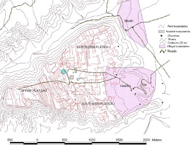
Figure 4: An overhead view of the Sikyon plateau with the modern villages of Vasiliko and Moulki shown. The digitised field boundaries as well as the previously excavated monuments are also visible.
The Sikyon project is an inter-disciplinary investigation into the ancient city of Sikyon. The primary focus of the project is on archaeological survey, with additional investigations into subsurface archaeology, historical documents, and an ethnoarchaeological study of the modern-day village and its inhabitants. Through the survey, the project hopes to identify different areas of use on the plateau using non-destructive techniques. The fieldwalking survey of the plateau comprises the vast majority of data to be used by the archaeologists, with complementary information derived from the geophysical and spolia (re-used ancient materials) surveys. While the focus of this article is on the survey data, knowledge of the other types of information and their potential for future research must be maintained.
The Sikyon Survey Project is unique among archaeological field surveys in Greece and the Mediterranean owing to the methodology it employs within the context of an urban centre. Archaeological surveys of this region primarily focus on extra-mural or rural areas with the sole intention of identifying habitation sites within a large landscape. One example, the Laconia survey, was conducted in the territory north of Sparta in the 1980s. An area of 70 square kilometres was covered in which more than four hundred sites were located (Shipley 2002). Another similar survey, the Methana Project, investigated an area of approximately 10 square kilometres and only identified sites (Mee and Forbes 1997, 34). Both of these projects surveyed the territories of cities without much deeper examination of their urban centres.
There have been previous attempts at urban surveys in Greece with limited results. The Tanagra Project surveyed a known urban area in the 1980s but has yet to be fully published. The survey team set out to produce a comprehensive map of the area and distinguish the major features of the city, such as the theatre, the residential quarter, the cistern, and the palaestra (Anon. nd a). Phlius, near Nemea, was surveyed in the 1990s but with such a coarse resolution (Alcock 1991, 441-4) that it proved unhelpful. Also, a real understanding of the urban area and its relationship to the rest of the valley was not a primary goal of the survey (Alcock 1991, 425). Lolos et al. provides a comprehensive review of the surveys listed above and other related projects as well as the methodologies implemented (2008, 268-71).
The Sikyon survey differs from these previous examples because of its intensive and systematic methodology. This survey, while it does not provide such highly detailed information on specific areas as excavation can, does provide a broad picture of the entirety of the ancient urban area. This will hopefully provide insights into the uses of the various areas of the city. The key to procuring usable data from this type of survey depends on sound methodology.
© Internet Archaeology/Author(s)
URL: http://intarch.ac.uk/journal/issue23/5/2.1.html
Last updated: Tue Mar 25 2008