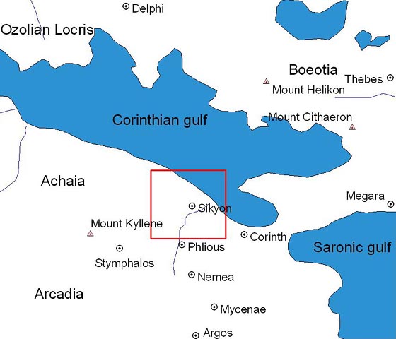
Figure 1: An overview map of the north-western Pelopennese showing Sikyon (highlighted), Corinth, and other City-states.
Sikyon is an ancient city located in the Greek Peloponnese about 3.5km south-west of the Corinthian Gulf between the Asopos and Helisson rivers (Fig. 1). According to ancient sources, the original city was located on the coast until 303 BC, when Demetrios Poliorkretes destroyed the city and refounded it on the neighbouring plateau (Levi 1971, 146). The modern villages of Vasiliko and Moulki occupy the south-eastern corner and north-eastern slope of the plateau respectively. The plateau, which is the focus of the project, has a surface area of approximately 240 hectares and is naturally divided into an upper and lower section. Sikyon is located close to the ancient city of Corinth, which can be easily seen from the eastern extents of the plateau. In antiquity, the Sikyon plateau overlooked the coastal roads to Achaia as well as significant routes into the southern Peloponnese (Lolos forthcoming). This prime geographic location gave Sikyon a place of relative importance in both the political and cultural life of the Peloponnese from the Archaic period on (Lolos forthcoming; Lolos et al. 2008, 272).
During Archaic times Sikyon was ruled by the tyrannic family of the Orthagorids and was one of the most powerful states of the Greek world (Lolos et al. 2008, 272). The city was home to famous painters and sculptors such as Pausias, Kanachos and Lysippos (Levi 1971, 121, 147, 154) and was considered a cradle of the arts throughout the Classical and Hellenistic periods (Lolos et al. 2008, 272). After the refounding of the city on the plateau by Poliorkretes, the city grew throughout the Hellenistic and Roman periods. The city experienced a golden age during the 3rd century BC under General Aratos, head of the Achaian Confederacy (Levi 1971, 150; Lolos et al. 2008, 273). This gave Sikyon great influence and power within Greece during this time. Sikyon fades away after the fall of the Roman Empire but appears again in sources relating to Frankish possessions in Corinthia of the 13th and 14th centuries under the name of Vasilika or Vasiliko. The village of Vasiliko is also often mentioned in archives of the Ottoman and Second Venetian periods, which was the 15th to early 19th centuries (Lolos et al. 2008, 273).
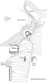
Excavations have previously been carried out at Sikyon by the American School of Classical Studies in the 1890s and early 1900s, by the Archaeological Society (A. Philadelpheus, A. Orlandos and K. Krystalli-Vosti) from the 1920s to 1950s and again in the 1980s (Lolos et al. 2008, 273). These excavations focused primarily on the area in and around the ancient agora and exposed a theatre, a temple, a palaistra, a bouleuterion and a long portico (Fig. 3). All of these buildings were dated to Hellenistic times (Lolos forthcoming). Rescue excavations have also been conducted since the 1960s on and around the plateau by the Ministry of Culture (Lolos et al. 2008, 273). An extensive survey of the territory of ancient Sikyon (also referred to as Sikyonia) was carried out by Yannis Lolos in the 1990s and the early 2000s. This broader survey mapped parts of the fortification wall around the edge of the plateau and sought the location of its gates. A selective bibliography of the history and previous archaeological work conducted at Sikyon can be found here
© Internet Archaeology/Author(s)
URL: http://intarch.ac.uk/journal/issue23/5/2.html
Last updated: Tue Mar 25 2008