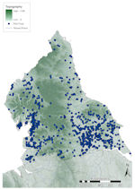
Figure 10: Distribution of finds in northern England against topographic base map
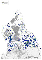
Figure 11: Distribution of finds in northern England against constraints base map
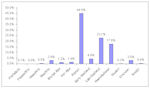
Figure 12: Chart showing PAS finds in northern England by period
Figure 10: Distribution of finds in northern England against topographic base map
Figure 11: Distribution of finds in northern England against constraints base map
Figure 12: Chart showing PAS finds in northern England by period
A range of topographic factors dominate the region north of the River Humber (Fig. 10). Much of this region is highland. Western areas are encompassed by the Pennines and Lake District, and in the east there is the higher ground of the Cheviots in Northumbria, and the North Yorkshire Moors. These all constrain the amount of ploughzone available and it is only the Tees Valley, Vale of York and Vale of Pickering that are lower-lying fertile river valleys. Ploughzone north of Newcastle is mostly limited to a 20km wide coastal strip. Urban settlement also provides a major element of the landscape (Fig. 11), most notably the M62 corridor along the south-western boundary and the north-eastern areas between the Rivers Tees and Tyne. Away from here, there is a scattering of urban areas in the Vale of York and Humberside. Forested areas are few (Fig. 11), limited to the Kielder Forest in the north, the North Riding Forest Park on the North Yorkshire Moors, and Grizedale Forest in the Lake District.
A total of 10,299 finds of all periods have been reported in Northern England, accounting for 8.4% of the national assemblage (Fig. 7). Of these, the north-west (Cumbria, Lancashire and West Yorkshire) accounts for only 17.1% (1763 records) of reported objects, with 82.9% (8536 records) from the north-east, highlighting the differences seen in the distribution (Fig. 11). A breakdown of the assemblage by period (Fig. 12) shows that it is dominated by Roman material, followed by Late and Post-medieval, between them making up 85.8% (8837 records) of all records. Prehistoric material accounts for just 6.1% (563 records), Early Medieval 4.4% (457 records), modern and foreign material 0.6% (60 records) and undated material 3% (312 records).
In general, the distribution of material is greatly affected by topography (Fig. 10), with finds spread across lowland areas, especially Humberside, the Vale of York and the Lancashire coastal zone. Markedly few finds have been made on ground over 100m OD, and all of those finds over 150m OD in the west are related to river systems. The valleys of the Rivers Lune, Ribble and Kent coming west off the high ground towards the Irish Sea have higher numbers of finds than the surrounding areas. In the east, few finds have been made on the high ground of the Cheviots or the North Yorkshire Moors. The comparatively lower ground of the Yorkshire Wolds is an area of relatively dense finds recovery, along with the low-lying Vale of York and Vale of Pickering. These areas provide the majority of findspots in northern England and the importance of the rivers here cannot be denied, with virtually all finds located relatively close to the rivers leading to the Humber. The Holderness Plain in south-east Humberside has produced few finds, but this is not surprising given that it is a wetland area of salt marshes and meres (Van de Noort and Ellis 1995, 1), although there are higher numbers of finds between these wetlands and the edge of the Wolds.
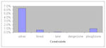
The potential constraints on the data (Fig. 11) make a visible impact, with very few finds outside of the ploughzone and low numbers in urban areas. A total of 847 finds (8.2%) were made within areas where constraints on recovery were calculated (Fig. 13), mostly in urban areas (659 records, 6.4%) which, although above the national average, is unsurprising given the levels of urbanism in lowland areas. Of note, however, is the correlation outside of the north-east of urban areas and clusters of finds around them, indicating that much detecting is undertaken near these urban areas.
The most important factor here is the limit of ploughzone farming, above which only 106 finds have been made, although settlement in these areas is historically sparse. The pattern of finds is interesting in comparison to the road networks, especially in the Vale of York where clusters of finds have been made along the major Roman roads to York as has been seen previously for Anglo-Saxon materials (Naylor 2004, 55). However, finds across the region also correlate well with modern A-roads and it is difficult to assess whether the finds relate to metal-detectorists working near A-roads, targeting the routes of Roman roads, or whether finds tend to be more prolific near Roman roads, especially given that Roman finds are most prolific in the PAS database. Finally, few finds have been recovered north of Newcastle owing to problems of gaining permission for detectorists to access land (David Petts pers comm).
The dearth of finds in highland areas is not unexpected, given both the lack of cultivated land and the historically low density of settlement. This is also true for the difference in the numbers of records between the east and west of the region. As a result, it is unlikely that areas above the limit for ploughzone farming would have produced large amounts of portable antiquities. However, other areas outside of the ploughzone, especially urban areas, have a profound effect on finds recovery. The lack of material from built-up parts of the region is no surprise, but the clusters of finds around many towns and cities was less expected and must reflect that many detectorists stay in their locality, travelling short distances to surrounding farmland. Other parts of northern England are magnets for detectorists (and, indeed, archaeologists), the most prominent being the western side of the Yorkshire Wolds and southern Vale of York, which has the highest finds density in the area. Many detector users travel from both the north-east and north-west to detect in these areas. This area is, however, a historically known 'core' area for settlement and so large numbers of finds are expected.
The breakdown of the region's assemblage by period follows the national trend, although Roman material is proportionally higher than general. This is matched, however, immediately to the south in East Central England and may reflect something of the actual nature of settlement and metal use in these regions in antiquity.
© Internet Archaeology/Author(s)
URL: http://intarch.ac.uk/journal/issue25/2/2.4.2.1.html
Last updated: Tues Apr 21 2009