Figure 18: Distribution of finds in east central England against topographic base map
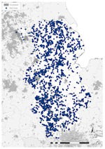
Figure 19: Distribution of finds in east central England against constraints base map
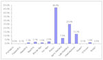
Figure 20: Chart showing PAS finds in east central England by period
Figure 18: Distribution of finds in east central England against topographic base map
Figure 19: Distribution of finds in east central England against constraints base map
Figure 20: Chart showing PAS finds in east central England by period
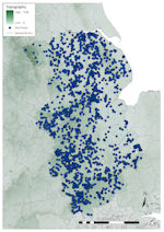
In eastern central England and Lincolnshire a different picture emerges to that seen further west and north (Fig. 18). Very little land rises above 150m OD, except the Jurassic ridge in Leicestershire and Northamptonshire and the Chilterns in Bedfordshire and Hertfordshire. The only land considered outside of the ploughzone (over 300m OD) is in the Peak District adjacent to Sheffield in the north-western corner of the region. Parts of the Lincolnshire Wolds rise above 100m OD, but 78% of North Lincolnshire is ploughed (compared to the national average of 46%). Rivers drain to the north, east and south. The River Trent dominates in northern and western areas, draining into the Humber basin, as does the Ancholme running through central and northern Lincolnshire to the west of the Lincolnshire Wolds. The Witham drains south through the Lincolnshire fenland, and the Nene and Welland north-east through the Cambridgeshire fens into the Wash. In Hertfordshire and Bedfordshire, rivers run south towards the Thames.
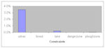
Potential constraints on data collection are fewer than further west and south, with no large-scale woodland or lakeland, and no areas designated as 'danger zones' (Fig. 19). Urban settlement mostly affects westerly and southerly areas, with few larger towns in the east. The north-west is heavily urbanised from Nottingham to Sheffield, and in the south, heavily built-up areas surround Greater London.
A total of 30,741 finds have been reported in East Central England, accounting for 25.2% of the national assemblage (Fig. 7). Of these, the southern half of the region (Buckinghamshire, Hertfordshire, Bedfordshire, Northamptonshire, Leicestershire, Rutland and Cambridgeshire) accounts for 53% (16,285 records) of reported objects, with 47% (14,456 records) from northern areas (Nottinghamshire, Lincolnshire, North Lincolnshire and South Yorkshire), highlighting the generally even spread in the distribution (Fig. 18). A breakdown of the assemblage by period (Fig. 20) shows that it is dominated by Roman material, which makes up a higher proportion of material than anywhere else, followed by Late and Post-medieval, between them making up 84.6% (25,987 records) of all records. Early Medieval accounts for 7.0% (2165 records), substantially higher than western or northern England.
The distribution of material across eastern central England is extensive in all areas except in the historic fenland areas around the Wash from South Lincolnshire to Huntingdonshire (Fig. 18). Finds are relatively evenly distributed, with noticeable concentrations running south-west/north-east from the northern Cotswolds along the northern edge of the Jurassic Ridge into western Lincolnshire along the lines of the Rivers Trent, Witham and Ancholme. There is a further defined line of finds along the Nene in Cambridgeshire. The kernel density plot shows the highest levels running south-east from North Lincolnshire to Northamptonshire, a pattern most likely related to the evolution of the PAS and the longer-term history of co-operation between metal-detectorists and local museums in this sector.
The modern road network seems less influential than further west or north, with the Roman road network, in general, of importance to levels of recovery. Northern and central Lincolnshire and South Yorkshire are the exception here, with little defined correlation towards Roman roads as opposed to modern roads. A large number of finds have been made across the Lincolnshire Wolds where no known Roman roads are extant, although prehistoric trackways may be of importance to recovery here (Ulmschneider 2000a, 59). In southern Lincolnshire, Leicestershire, Northamptonshire and Cambridgeshire, especially the Leicester/Northampton/Peterborough region, Roman roads are foci for finds recovery. The situation may be the same in Hertfordshire but the density of known Roman roads here makes any conclusion difficult.
Although relatively few, the potential constraints on the data (Fig. 19) make a visible impact, with very few finds outside of the ploughzone (7 records, <0.1%) and low numbers in urban areas. A total of 1128 finds (3.7%) were made within areas where constraints on recovery were calculated (Fig. 21), mostly in urban areas (1062 records, 3.5%), although even here at a level below the national average. As elsewhere, clusters of finds are seen outside urban areas, especially in the west, indicating that much detecting is undertaken near these urban areas.
Eastern Central England represents much of the boundary between the highland zones of the west and lowland zones of the east. The dearth of records from the north-west corner of the region (around Sheffield) is typical of the surrounding areas to the north and west. Conversely, the high densities of records in Lincolnshire, Northamptonshire, Cambridgeshire and Leicestershire are commensurate with the southerly areas of Western Central England and East Anglia. As expected, the effect of urbanism is profound in the west and south of the region, but the clustering of finds immediately outside is interesting, probably attesting to the nature of detecting. Alongside this, the importance of communication routes (rivers, Roman roads and prehistoric routeways) is clear. This may reflect either deliberate targeting by metal-detector users and field-walkers, hence the high numbers of finds, or the nature of ancient settlement, but without knowledge of where material has not been found this is difficult to ascertain.
The breakdown of the region's assemblage by period follows the national trend, although Roman and Early Medieval material are both proportionally higher than areas further west and north, and slightly lower than East Anglia and may reflect trends in the nature of settlement and metal usage in England in antiquity.
© Internet Archaeology/Author(s)
URL: http://intarch.ac.uk/journal/issue25/2/2.4.2.3.html
Last updated: Tues Apr 21 2009