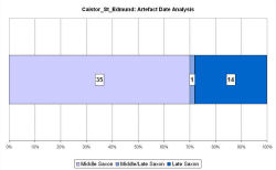
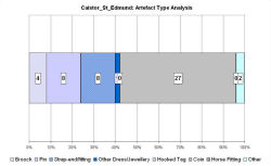
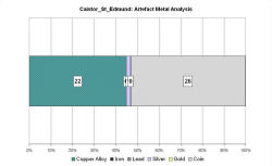
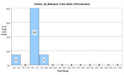
Fingerprint charts for i) artefact date analysis, ii) artefact type analysis, iii) artefact metal analysis and iv) coins – date of production


The parish of Caistor St Edmund lies just 2km south of Norwich. It includes two villages – Caistor St Edmund itself and the old village of Markshall. Caistor is named after the Roman town of Venta Icenorum; the St Edmund suffix records how the abbey of Bury St Edmunds owned the parish, as is recorded in Domesday. The name Markshall probably derives from Old English meaning Maerec's corner or nook, and is also recorded in Domesday.
During the Anglo-Saxon period the walled part of the Roman town appears to have fallen into disuse. There is no direct evidence for Saxon settlement within the walls, although the number of Middle Saxon finds from around the town, especially to the west, suggests settlement in the area. The location of St Edmund's church in the corner of the walled town is reminiscent of a number of Middle Saxon minster foundations (Pestell 2003, 130). The VASLE dataset is based upon records from the EMC and the Norfolk HER. Aerial photographs show at least one area of possible Early Saxon SFB. Three Early Saxon cemeteries in the parish have been completely excavated or destroyed. The cremation cemetery at Markshall was excavated in the 19th century. The second cemetery overlooks Venta, and was excavated between 1932-35, when 500 cremations and 57 inhumations were recorded. The third cemetery at Harford Farm was excavated during development of the Norwich Southern Bypass. It was used between the 7th and 8th centuries AD when bodies were either buried in coffins or placed directly into the grave. Some of the graves contained rich jewelry and other wealthy items.
Fingerprint charts for i) artefact date analysis, ii) artefact type analysis, iii) artefact metal analysis and iv) coins – date of production


© Internet Archaeology/Author(s)
URL: http://intarch.ac.uk/journal/issue25/2/4.4.11.html
Last updated: Tues Apr 21 2009