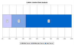
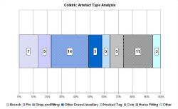
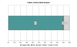
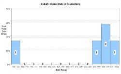
Fingerprint charts for i) artefact date analysis, ii) artefact type analysis, iii) artefact metal analysis and iv) coins – date of production
Colkirk lies in north-western Norfolk, within the district of Breckland. It is south of Fakenham and north-west of East Dereham. The parish has an undulating landscape, 48-80m in height. A number of streams originate here, with two flowing south and westwards and two flowing northwards.
There is a probable Early Saxon inhumation cemetery here and some Middle Saxon artefacts have been found in the parish. The VASLE dataset is derived from the Norfolk HER with some coin records from the EMC. Coins, strap-ends and a disc brooch from the site of the probable cemetery suggest activity continued there in some form. A Middle Saxon coin was found close to Colkirk village; brooches, hooked tags and a fastener have been collected near Oxwick. Many of the sites with Middle Saxon artefacts have also produced Late Saxon finds.
Fingerprint charts for i) artefact date analysis, ii) artefact type analysis, iii) artefact metal analysis and iv) coins – date of production
© Internet Archaeology/Author(s)
URL: http://intarch.ac.uk/journal/issue25/2/4.4.15.html
Last updated: Tues Apr 21 2009