Fingerprint charts for i) artefact date analysis, ii) artefact type analysis, iii) artefact metal analysis and iv) coins – date of production
Reference: Rogerson 2003
Archives:
http://ads.ahds.ac.uk/catalogue/search/fr.cfm?rcn=NMR_NATINV-357450
http://ads.ahds.ac.uk/catalogue/search/fr.cfm?rcn=NMR_NATINV-868432
Middle Saxon Congham sits adjacent to the modern village at the foot of the Chalk Scarp. The River Babingley, which flows westwards into the Wash, is 2km to the north, and the Icknield Way passes through the site. The Domesday Book records the village as having only a single church, but also a fishery and a salthouse.
Finds of Early Saxon date include a large number of Early Saxon brooches, indicating a mixed cemetery involving inhumation and cremation rites. Finds of Ipswich Ware and Middle Saxon metalwork were first made in the 1950s and in 1970 excavations by Keith Wade revealed the clay floor and post-holes of a Middle Saxon building.
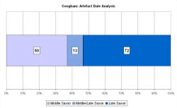
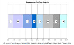
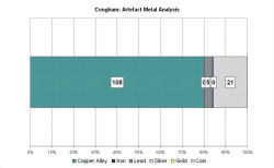
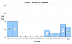
Since 1993, a detailed metal-detector survey has recorded Middle Saxon finds strung a kilometre along the Icknield Way running north-north-west to south-south-east, and covering over 10 hectares. The Late Saxon All Saints' church is situated on the western edge of this scatter. The quality and range of metalwork is not exceptional but there are 13 coins and lots of other metalwork, as well as a single sherd of continental pottery. The VASLE dataset is derived from the Norfolk HER and the EMC.
Fingerprint charts for i) artefact date analysis, ii) artefact type analysis, iii) artefact metal analysis and iv) coins – date of production
© Internet Archaeology/Author(s)
URL: http://intarch.ac.uk/journal/issue25/2/4.4.16.html
Last updated: Tues Apr 21 2009