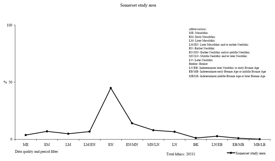
Figure 2: The composition of lithic scatters recovered across the study area
The grouping of stone artefacts into data quality and period filters has made it possible to chart the compositional variability in more than 150 lithic scatters across the landscape (Figure 2). Compositional variability, as denoted by lithic groupings is interpreted here to indicate change through time. This variability is viewed as technological, typological and chronologically significant. This data is viewed as mostly diachronic, but certain groupings also indicate overlaps in traditions of stone working and time - a degree of synchronicity (see column on Technology and typology in Table 1). Despite this, it is argued the hierarchical data quality and period groupings do represent actual change through time. Over 20,000 lithic artefacts are presented in Figure 2. This includes the Shapwick Project survey data with other lithic scatter assemblages recovered across the study area. It is also important to note, that in addition to the lithics (struck flint and chert artefacts), stone objects are also recorded at these lithic scatters. On Mendip, ten locations provided accumulations of stone objects, such as hones or rubbers of (Mendip) Old Red Sandstone and Greenstone. In the lowlands of the Polden Hills, examples of such artefacts are small in number, but are recorded and may also be, at least in part, prehistoric in origin (Roe 2007).
In Somerset, the recognised national change from blade to flake technology (Ford et al. 1984; Pitts 1978; Pitts and Jacobi 1979) and the attendant changes in craft skills (Edmonds 1995) has been demonstrated. For example, the study of small excavated and radiocarbon-dated lithic assemblages, from the seaboard, lowlands and uplands show the same technological change (Brown 1986; Gardiner in Hosfield 2005; Jacobi 2005; Saville 1990). Indeed, despite the observation that most flint appears to have been imported into the area as Downland nodular flint from the Wessex chalklands over thirty to forty kilometres away (Bond 2004b; 2005), the size, shape and technology of these industries are comparable. Therefore, the trend presented in Figure 2 can be argued to demonstrate a real change in lithic scatter composition from the early Mesolithic to the later Bronze Age.
Importantly, the spike in the line diagram is centred on the earlier Neolithic/middle Neolithic grouping (Fig. 2). This demonstrates a decline in the number of lithics in the periods following the earlier Neolithic. In the previous period (later Mesolithic and/or earlier Neolithic), the number begins to increase, but in the early Neolithic the value peaks at just under fifty percent, before dropping again in the earlier Neolithic and/or middle Neolithic. Given that the grouping either side of the earlier Neolithic is less diagnostic in terms of retouched forms and the type of waste present (see Table 1), this graph may also indicate an overlap between groups with different quality data and period resolution. It is argued here that proportions of a shared stone working tradition are represented, either side of a chronologically significant spike. This indicates a peak in activity across the study area in the earlier Neolithic, suggesting either an increased volume of activity at these locales with more artefacts being discarded, or more regular activity in that period. The presence and absence of lithic artefacts in the data groups can be used to infer less of a human presence. After the earlier Neolithic and/or middle Neolithic grouping, either fewer visits occurred at these lithic scatters and/or a progressive pattern of abandonment may have occurred (Fig. 2). This trend in lithic scatter composition is contrary to what may be expected. For example, in the Stonehenge environs survey (Richards 1990), the Maiden Castle-Dorset Ridgeway survey (Woodward 1991; Woodward and Bellamy 1991) and on the Marlborough Downs (Gingell 1992), lithic scatters became denser in the later Neolithic into the earlier-middle Bronze Age. Hence, the central Somerset trend in lithic scatter composition may point towards a more regional pattern in settlement activity, contrasting with that of the chalkland regions.
This data set represents the larger scale long-term tradition of landscape occupation, as inferred through discarded stone artefacts (Fig. 2). It provides a framework for individual lithic scatters. Crucially, patterning in assemblage composition at the individual scatter may or may not link with that traced across the landscape. But, cumulatively, the individual scatter contributes to the broad pattern. Macro and micro scales of lithic analyses are entwined.
Further analysis at the macro-level of analysis can address variability between twelve data quality and period groupings: Mesolithic to indeterminate middle Bronze Age or later Bronze Age (Table 2). A total of 12,942 lithics, consisting of retouched forms, cores and waste have been analysed. The data quality and period grouping with the highest number of lithic scatters in any one data set and attributed number of individual lithic artefacts is that of the earlier Neolithic. This data set provides 44.8% (n=5808) artefacts, the largest single component and also the highest arithmetic mean and median value present. The pivotal position of this data filter is the middle Neolithic. This break in the data is also underlined by the number of artefacts and size classes across the groupings (Table 2). The earlier Neolithic data demonstrates the point when the former earlier prehistoric lithic scatters become more diverse in the type and number of artefacts, per lithic scatter. These observations support the argument that there is a natural quantitative division between earlier Neolithic and earlier Neolithic/middle Neolithic data and that which is post-middle Neolithic. With the trend analysis across the landscape (Fig. 2) this patterning is argued to represent a signature of the ebb and flow of mobile communities, within and across the study area. Fewer numbers of lithics can be argued to equate directly to a reduced presence of people within the study area. Whilst it need not be the case that fewer lithics discarded relate directly to fewer people visiting lithic scatters, it may be suggested that a less sustained presence is demonstrated. People may come and go, but longer duration of stays would imply more discard. This rationale is a central premise in lithic analysis.
This change in artefact discard occurs at a time when the Mendip landscape becomes more monumentalised (see Bond 2006, chapter 6). The causation and processes involved in this temporal change may be the result of less frequent seasonal or within season visits and/or fewer people present at each lithic scatter (and across clusters at certain locales). This implies a change in perception of these humanised places. As places are less frequently visited, or visited by fewer people, fewer lithics are discarded. The social fabric of the landscape is transformed, perhaps to a remembered and more mythical world, with a less regular and sizable community present. This is particularly so, from the later Neolithic to later Bronze Age. Whilst monuments were constructed, such as Gorsey Bigbury henge, the Priddy Circles henges and Bronze Age barrows, it appears the lithic scatter data indicates a reduction in occupation. Monument building need not be evidence of occupation, rather the presence of people during construction and maintenance. This may have occurred at particular points in the years and not necessarily lead to the discard of quantities of lithics. It is argued elsewhere that a relationship existed between different social groups in Wessex and the South-West, including central Somerset (Bond 2005, 2006). These groups may have visited seasonally, constructed monuments, deposited artefacts and human remains in caves and then returned to the chalklands. At Gorsey Bigbury henge the excavated ditch did yield classic Beaker lithic assemblages (ApSimon et al. 1976). But, even within this assemblage a later Mesolithic and earlier Neolithic component was isolated suggesting ad-mixture of the deposit with former occupations. Similar findings are noted at Bos Swallet on Mendip (ApSimon 1998). Elsewhere across the landscape, at lithic scatters fewer characteristic later Neolithic-early Bronze Age waste (larger flakes, hard hammer production) appear to be discarded.
The spatial relationship between lithic scatters may also be considered. The application of Geographical Information System and simple buffer analysis (Wheatley and Gillings 2002, 148-149, fig. 7.1) can be utilised to investigate associations between lithic scatters and different data quality and period groups. Lithic scatters are mapped and seven concentric circles, or distance buffers were applied from each centre point: from 5 to 500m radius (Table 3). The spatial relationship between lithic scatters with differing data quality and period filters was tested. Five main observations are apparent:
The spatial patterning shown in Table 3 is interpreted as indicating change in the lithic scatters which occurred over the long term. This is the result of change in histories of occupation at each scatter, most likely part of a seasonal cycle of settlement sampled within the study area. The act of re-visiting lithic scatters over generations was not a random process. Past people chose to visit each place. Seemingly, the knowledge of past use of each scatter does appear to be a factor in the re-selection of locales by later people (Table 3). The active creation of lithic scatters is argued here to be an accumulative process, at least up to c.2900 cal. BC!
Generations of human agency in a set location are recorded by the placement of lithic scatters in the study area. These people may not have settled in a continuous succession, but a presence is demonstrated, up to c.2900 cal. BC. Lithic scatters were not sited on an ad-hoc basis; social groups with knowledge of their historical landscape created these humanised places.
© Internet Archaeology/Author(s) URL: http://intarch.ac.uk/journal/issue26/1/3.html
Last updated: Mon Oct 19 2009