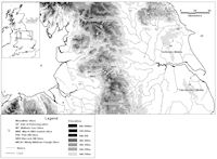
Figure 1: The relationship between selected Mesolithic sites in Northern England
Landscape archaeology and hunter-gather mobility has increasingly been the centre of attention in Mesolithic studies (e.g. Donahue and Lovis 2003; 2006) but as the only remains to be found are often chipped stone tools, it is surprising that few direct connections have been made between lithics and the landscape in either practical or theoretical terms. This article will attempt to go some way towards redressing this by suggesting the possible effect of and influences of lithic technology within the mobility strategies of the Mesolithic hunter-gatherers in Northern England.
Specifically, this article intends to demonstrate that persistent places (Barton et al. 1995) may have often been resource locales in the landscape, which therefore had significant consequences and influences on raw material consumption and tool manufacture. Key to this study is the introduction (into the Chaîne Opératoire model of lithics analyses) of the notion of 'Equipotentiality' (Preston 1999)
This new term will be defined and explored in relation to hunter-gatherer mobility strategies, along with other processes such as retooling (Hoffman 1992) or resharpening. A model for equipotential tool use at both intra- and inter-site levels is proposed, together with its influence on hunter-gatherer mobility strategies.
First we must define Chaîne opératoire and understand why it is important for Mesolithic studies. Traditionally, Mesolithic lithic studies have been largely typologically based, but in order to understand hunter-gatherer mobility fully from the ubiquitous lithic remains, analyses must be grounded in the notion of Chaîne Opératoire, which means technological or attribute-based studies rather than just typological. This is because each piece has attributes that reveal the 'narrative' of its manufacture, use and discard.
First described by André Leroi-Gourhan (1943), the Chaîne opératoire model elucidates technological systems and the dynamic processes (operational chains) of a lithic's life cycle from raw material procurement, its manufacture, use and discard. It allows insight into past behaviour both at different temporal scales (from seconds to years) as well as spatially through 'exploding' artefacts across the Mesolithic landscape (Warren 2006). It necessarily implies that an artefact found by the archaeologist is only the last form in a series of transformations and operational chains (and in my view post-depositional taphonomic processes also). Additionally, the tool found often only represents part of the original tool. For example, microliths could have been part of a composite tool (e.g. an arrow or sickle).
Persistent places were first identified by Barton et al. (1995) in the Black Mountains (Wales) through technologically based lithic analyses of multi-component (and often multi-period) assemblages. Persistent places are single locations (or clusters of sites) that were repeatedly visited by Mesolithic hunter-gatherer-groups. These visits were usually of short duration and were often visited for different tasks/reasons.
Many northern English Mesolithic sites and site clusters that fit this definition are often (though not exclusively) located near prominent landmarks known as 'hand rail' features in navigational terms. In the Pennines these possible persistent places are located at the heads of drainage systems (locally known as cloughs, and reinforcing the idea of river systems as navigable routes), watersheds (Stonehouse 1987; 1994), lakes and tarns (Donahue and Lovis 2006), crags, and conical hills (Davies 1943). As in the Black Mountains (Barton et al. 1995), these Central Pennine sites were strategically placed for the exploitation of specific seasonal resources and it has often been assumed that these sites were located in order to exploit red deer (e.g. see Clark 1954; Mellars 1976; Jacobi 1978; Stonehouse 2001). However, Conneller (2005) reminds us that many of these upland sites are palimpsests, reflecting a series of activities with debris generated over a variety of different temporal scales. We therefore should not be restricted by labels such as 'hunting camp'. From this perspective, and as can be inferred qualitatively from the Pennine lithic evidence described in my current doctoral research, 'sites' were visited several times a year by different sections of the same group or groups, often for different purposes.
Thus as sites were often revisited, the hunter-gathers must have known that tools had been previously left at these locales or at least would have noticed the ubiquitous scatter of discarded tools at these locations (Preston 1999). Therefore these palimpsests in effect became caches. Indeed, Conneller (2005, 51) states:
'Some objects not through their movement but through their continued presence at places, establish relationships between people and places. The meaning and knowledge of objects left at a place sustained it in memory.'
It is unlikely that the dense Central Pennine site clusters (Fig. 1) were actually very large persistent places/palimpsests and in most cases were probably visited by the same groups on several occasions. Examples include the March Hill-Lominot Site Complex (West Yorkshire), and the Windy Hill-Dean Clough site complex (Greater Manchester-West Yorkshire border). Other examples elsewhere are the Malham Tarn Sites (North Yorkshire), and the Vale of Pickering sites (North Yorkshire).
Figure 1: The relationship between selected Mesolithic sites in Northern England
Some of these clusters are described as paired sites (Jacobi 1978), whereby one site often has other sites nearby (often separated by only a few metres) that are identical in composition, lithic technology and styles, so that Warcock Hill South and Turnpike (West Yorkshire), c. 19m apart, and Waystone-Hassocks 1 and 2 (West Yorkshire) and Pointed Stone 2 and 3 (North York Moors) which are both 20m apart. In fact, both the Warcock Hill sites mentioned and the Pointed Stone sites' lithic assemblages (e.g. microliths) are technologically and stylistically similar to Star Carr, thereby providing strong evidence of links and mobility within the region.
Other evidence for these persistent places can be found in several forms: firstly revisitation is suggested by the activity/operational chains inferred by the lithics, stable isotope/dietary evidence, and faunal studies, all of which imply multiple activities at various sites, often over different temporal scales. This appears to be particularly the case at Star Carr and the vale of Pickering sites (e.g. see Clark 1972; Pitts 1979; Caulfield 1980; Dumont 1988; Legge and Rowley-Conwy 1988; Mellars and Dark 1998; Preston 1999; Schulting and Richards 2002; Conneller and Schadla-Hall 2003; Dark 2000; 2003; Conneller 2007; Milner 2007).
Secondly, evidence of investment at these sites could be taken as an indication that the hunter-gatherer groups intended to return to sites, and/or them seeing this as a resource node in the landscape. Examples of such investment includes the table/cooking/anvil stones, formal hearths and fire pits dug into the iron pan (e.g. at Pule Hill); tent or shelter structures found at Pule Hill Base and Lominot (West Yorkshire), Piethorn Brook (Greater Manchester), and Deepcar (South Yorkshire) (Buckley 1939; Radley and Mellars 1964; Radley 1968; Poole 1986; Spikins 2002; Stonehouse 1987; 2001). This investment evident in the archaeology provided one reason for the hunter-gatherers to return and use the site as a resource node.
© Internet Archaeology/Author(s) URL: http://intarch.ac.uk/journal/issue26/25/1.html
Last updated: Wed Jul 29 2009