We acknowledge the contributions to this section of Dr Christopher Fisher, Colorado State University, and three graduate students, Anna Cohen, University of Chicago, Francois Dengah, University of Alabama, and Sylvia Deskaj, Michigan State University.
In 2005 SVP archaeologists surveyed a series of large terraces and associated ruined walls and structures at the far end of the southernmost neighbourhood in Theth, that of Grunas. The site (Site 006) was excavated in 2006, 2007, and 2008, producing copious evidence for construction and occupation in the Early Iron Age [View Comments], c. 800 BC (see Grunas excavation databases; Table 4). The terrace walls block and fill a tributary gorge that runs along the eastern edge of the site (Figs. 4 and 5, 11 and 12). Their construction would have required careful planning and a large labour force; however, it would have been worth the effort, considering the defensive nature of the site. The site is bordered on the west by the Shala River, which passes through a deep gorge, and is protected by steep cliffs. The promontory on which the site is located comes to a point at its southernmost end, and looks out over the lower, southern part of the valley. The only trail from southern to northern Shala scales the cliffs to the south, and runs alongside the eastern edge of the site (whereas the modern road was cut into the cliffs to the west side of the site on the other side of the river gorge). Its occupants could have easily controlled access to northern Shala and beyond.
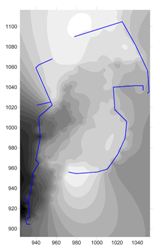
Figure 11: Two dimensional contour map showing the terraces and fortification walls at SVP Site 006. North is up, scale in metres, white is highest elevation (Galaty and Lee).
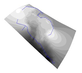
Figure 12: Three dimensional contour map showing the terraces and fortification walls at SVP Site 006. North is up, scale in metres, white is highest elevation (Galaty and Lee).
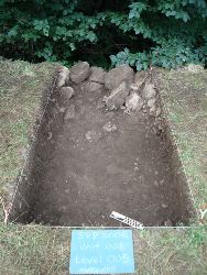
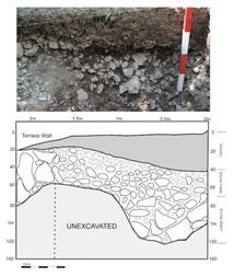
In 2008 we excavated a 1x2m unit (Unit 001) perpendicular to the lowest and largest terrace wall at Grunas in order to determine its construction sequence (Figs. 13 and 14). Large rocks were present at the lower levels of the unit and, given the west to east sloping stratigraphy, it appears likely that they served as an internal, ramped buttress that supported the inward-leaning terrace wall from the inside. These observations indicate that this lowest terrace wall, and therefore the whole site, was constructed in a single building phase at the start of the Iron Age.
Figure 13: Photo of 2008 Unit 001 at Site 006, from east (Galaty and Dengah).
Figure 14: Photo and drawing of the north profile of 2008 Unit 001 at Site 006, from south (Galaty and Dengah).
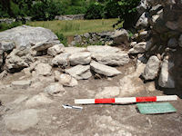
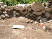
Unit 002 was excavated as a 2x4m block and was situated within Structure 002 (Figs. 15 and 16). Our primary goal in excavating Unit 002 was to determine whether Structure 002 was built in prehistoric or later times. To the west, we exposed the remains of a clay hearth. Diagnostic artefacts, such as two unfired bullets from the 1880s and metal nails, suggest that Structure 002 was a house occupied during the late 19th or early 20th century before being abandoned. The builders' attention to detail and the house's association with a storage structure (Structure 003), suggests year-round occupation. Such early single-storey stone houses (Fig. 17) eventually gave way to the multi-storey stone houses common in Shala today.
Figure 15a: Photo of 2008 Unit 002 in Structure 002 at Site 006, looking east. Note threshold at center of photo (Galaty and Cohen).
Figure 15b: Photo of 2008 Unit 002 in Structure 002 at Site 006, looking west. Note clay hearth at centre below wall (Galaty and Cohen).
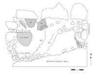
Figure 16: Drawing of the floor of Unit 002 in Structure 002 at Site 006; BR = bedrock (Galaty and Cohen).
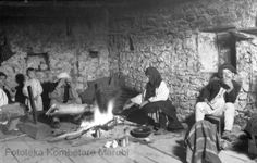
Figure 17: Photo of the interior of an early northern Albanian house. By Pici, date unknown. Note the clay hearth. Courtesy of the Fototeka Kombëtare Marubi, Shkodra, Albania.
A 1x1m unit, Unit 004, was excavated immediately below the westernmost terrace wall, on a narrow ledge just above the precipitous drop into the river gorge, with the aim of identifying midden deposits. No artefacts were recovered and it appears likely that refuse was either not discarded below the western terrace wall or that it was washed away post-deposition.
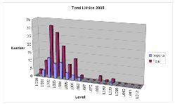
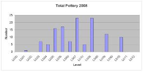
We excavated Unit 003, a 4x4m unit, in the middle of Terrace 006, near where a 1x1 metre pit had been excavated in 2007 (Fig. 5). Due to Early Modern ploughing techniques, the first three levels of Unit 003 (down to 0.3m) were plough zone. The artefacts recovered from Unit 003 demonstrate that there were three periods of prehistoric occupation at Grunas. In both 2007 and 2008, the majority of flint tools, most of them imported, was found in the upper strata, primarily levels 002-004 (Fig. 18; see for example L031, L059). Similarly, the majority of prehistoric ceramics, although rarely indicative of diagnostic forms, was found in levels 005-010 (Fig. 19; Fig. 20; see for example P195, P449, P479, P498, P504, P524, P578, P580). These results reflect an initial construction and occupation of the terraces in the early Iron Age, around 800 BC. A second occupation, during the later Iron Age, spans roughly the 8th to 6th century BC. Evidence for a third and final prehistoric occupation is demonstrated by the preponderance of chipped stone in the upper strata, suggesting a seasonal hunting or pastoral camp. The site was then abandoned until the Early Modern period, which is associated with Structures 001 to 003.
Figure 18: Figure showing lithic density by level from 2008 Unit 003, Site 006 (Galaty).
Figure 19: Figure showing pottery density by level from 2008 Unit 003, Site 006 (Galaty).
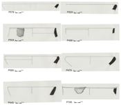
Figure 20: Drawings of diagnostic pot sherds from SVP Site 006 (Bushati).
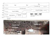
Importantly, at the top of Level 006, in the eastern half of the unit, we hit hard-packed clay. This was identified as an artificial platform that may have served as the floor of a structure (Fig. 21). Consequently, we began excavating the unit in two halves: the eastern half or 'floor' versus the western half or 'fill/midden'. Analysis of the chipped stone and ceramics reveals differential patterns of discard for the floor and the fill deposits. Many more lithics, made from imported and local material, were found in the fill (n=17) than in the floor (n=3). In addition, 75 ceramic sherds were recovered from the fill and only 12 were recovered from the floor. These patterns strongly suggest that the platform was an artificial construction made from clay that was brought to the site from elsewhere and that the living/working surfaces were regularly swept clean. If the lower terraces at Grunas were in fact occupied by numerous such platforms and houses then the Iron Age population of the settlement must have been quite large.
Figure 21: Photo and drawing of the north profile of 2008 Unit 003, Site 006 (Galaty and Fisher).
It is unclear whether the residents of Grunas were there year-round or seasonally, but given the nature of the housing at Grunas - probably small wattle-and-daub houses - the latter is more likely. If the occupants of Grunas were indeed transhumant, where did they come from? Might our understanding of Iron Age Grunas teach us something about the later, Medieval to Modern occupation of Shala, and vice versa? Oral and archival historical records indicate that the year-round residents of Shala sought refuge in the northern mountains just prior to the final Ottoman conquest, sometime in the late 15th century, having come initially from the region of Shkodra, a large coastal city. As alluded to above, however, like their Iron Age predecessors, the Modern occupants of Shala were not entirely isolated. On the contrary, our ethnographic data reveal that in Modern times there was almost constant travel between Shala and the coast and inland to Montenegro and Kosova (audio clip #3). Residents of Theth remember travelling over the mountain passes to markets at Gusinje, Peja, and Shkodra to sell their pastoral products and buy grain for bread. It is highly likely that the seasonal residents of prehistoric Shala did likewise and that control of the mountain passes during the summer months was a worthwhile and potentially lucrative undertaking, one well worth defending from a strategic site like Grunas.
However, unlike the Modern residents of Shala, who lived in extensive villages, the Iron Age residents had an intensive, highly focused impact on the landscape and produced an impressive, nucleated, but ultimately limited, built environment. We found Iron Age artefacts at two sites only: Site 006 (Grunas) and Site 007 (Dakaj), an impressive fort located at the centre of the lower valley (discussed below; SVP Site 008 in the neighbourhood of Gimaj might be Iron Age, based on similarities between the terraces there and at Grunas, but test excavations in 2007 produced no definitive evidence for prehistoric occupation). We think the radical differences in landscape, settlement, and the built environment between Iron Age and Modern Shala are the result of two very different types of engagement with the outside world.
Archived Comments
SVP Site 006, with its large terraces, is unique in Shala and, to the best of our knowledge, in Albania. We would be interested to learn of similar sites from elsewhere in Albania or the Balkans.