PREVIOUS
NEXT
CONTENTS
HOME
1.2 Site background
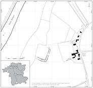
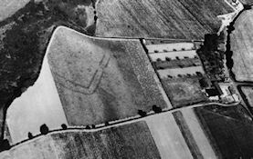
Blackstone lies at the northern end of a gravel terrace on the east bank of the River Severn just before it enters the Severn Gorge (north Worcestershire/south Shropshire). A cropmark enclosure (NGR SO792736; WSM 236; Fig. 1) was discovered by Arnold Baker in 1957 as a result of aerial reconnaissance (RCHME ref SO7973/2 frame 580; WSM 7260). This aerial photograph (Fig. 2) shows two parallel ditches cutting off a promontory, at about 30m AOD, overlooking a narrow floodplain, and with the River Severn c. 200m to the west and some 15m below. The promontory is formed by a steep slope from the river terrace down to the floodplain, and a steeply sloping dry valley. The enclosure had an internal area of about 0.5ha, and there was an entrance on the eastern side. A few internal features were visible on the aerial photograph, and these were shown by excavation to be pits and ditches. Owing to its regularity of form, Graham Webster initially interpreted the cropmark as a Roman military camp (Geoff Taylor pers. comm.).
The site is located in Wribbenhall, which is within the parish of Kidderminster Foreign, and is near Blackstone Rock, a high cliff and notable local landmark beside the River Severn on the east side of the river (Fig. 3).
1.2.1 Geology
The site is on glacio-fluvial gravels of the Third Terrace overlying the soft red sandstone of the Triassic Bunter Beds (BGS sheet 182; 1:63,560). The soils are Newport 4g type (Ragg et al. 1984), which are well-drained sandy soils, sometimes very acidic and prone to drying out (Beard et al. 1986, 57).
1.2.2 Archaeological and historical background
Several major hillforts typically mark out the period in the wider landscape, though in Worcestershire there is relatively little known about these from archaeological study, apart from at Kemerton Camp (Hencken 1938) and Conderton Camp (Thomas 2005), both on Bredon Hill. Smaller enclosed Iron Age sites are also poorly understood and to date few published sites have been excavated in detail (Wychbold: Jones and Evans 2006; Throckmorton: Griffin et al. 2005). Other Iron Age remains have been recorded in some profusion at Droitwich (Woodiwiss 1992) where they relate to salt production, whereas occasional features possibly of this period have been recorded at Worcester (Dalwood 2004, 36).
Developer-funded evaluation, which has been carried out since the adoption of PPG16 (DoE 1990), is allowing some headway in the study of the period in Worcestershire as a whole, as smaller sites are now coming to light in the general landscape and are being recorded in the course of development, although sometimes such sites are rather enigmatic, such as the solitary, and apparently isolated, pit at Madeley Heath in north-east Worcestershire (Hurst and Pearson 1996). There was also the major discovery of what was, at the time, the largest Iron Age coin hoard in the country, from a previously unknown site just north of Pershore (Hurst 2000a), where there is an extensive spread (4ha) of enclosures and possible roundhouses. These sites indicate a wide range of different settlement types, and the exceptional nature of some of these discoveries suggests that our understanding of the Iron Age in this area still has a very long way to go.
Overall, therefore, the Iron Age period in Worcestershire is generally under-studied, as there have been few opportunities to implement archaeological work, and, where archaeological work has been undertaken on gravels, it can still be awaiting publication decades later, as in the case of Beckford (though fortunately the latter is currently being addressed through funding from ALSF). No such modern excavation opportunity has arisen to the north of Worcester, apart from currently at Top Barn (SO 820610) where quarries are now operating some 12km south of Blackstone.
1.2.3 Known sites in the vicinity of Blackstone
Blackstone lies at the north end of an extensive area of gravel terrace of the middle River Severn, well known for revealing large and easily recognised complex areas of cropmarks, many of which are loosely assigned an Iron Age and Roman date. These constitute some of the most striking representations of archaeology in a region that has few earthwork remains pre-dating the medieval period. However, in many cases these cropmarks have now been quarried away without any archaeological record, as they related to areas for which old planning permissions existed.
In the general vicinity of Blackstone the only major excavation work took place some years ago:
- by Walker (1958) at Larford, 5km to the south and on the west bank of the river, where Bronze Age, Iron Age and Roman remains were recorded in advance of quarrying, the Iron Age being represented by a single pit;
- by Green (1961), 4.5km to the south and on the west bank of the river, where a barrow assumed to be of Bronze Age date was recorded (the only dating being Roman pottery in upper ditch fills), and;
- by Hunt et al. (1986) at Holt, 12km to the south and on the west bank of the river, where archaeological rescue work recorded both a single- and double-ditched enclosure, the former being attributed to the Iron Age and the latter most likely to the Roman period.
Nor has much opportunity arisen in the modern era to investigate the field archaeology of this area during the course of development or otherwise, with the exception of watching briefs on pipeline work (Dinn and Hemingway 1992; Jackson et al. 1994). The latter have suggested that sites in this area are especially characterised by lithics indicative of Mesolithic, Neolithic and Bronze Age activity, whereas Iron Age and Roman activity is relatively poorly represented. In general, therefore, interventions for over half a century have yielded few structural remains of Iron Age date in the vicinity of Blackstone to provide a wider context for the site.
Aerial photography has also identified other discrete archaeological features very close to the Brant Farm site both to the north and south (e.g. WSM 8143, and 7261-2 respectively), and, although these remain undated, their orientation suggests that they may be contemporary with the enclosure described here. These are also rectilinear in character, but are much smaller than the Blackstone Iron Age enclosure. Further north from Blackstone is largely an archaeologically unknown tract, since any related evidence would be largely obscured by tree cover (the Wyre Forest). More recently, however, the use of LiDAR survey is now leading to significant discoveries even here (A. Mindykowski pers. comm.).
Another potential source of useful data is the Portable Antiquities Scheme (PAS) and this has recorded a cast copper alloy late Iron Age terret/harness ring from about 1km to the north-east of the enclosure site (WAW-CE36B3; SO798742; Angie Bolton pers. comm.). Some (undated) pottery sherds are also known from the Severn shingle bed in the general vicinity of the site (Liz Cowley of Bewdley Museum, pers. comm.). Where sites are difficult to pin down, and where activity might have led to more insubstantial remains, the recognition, recovery and identification of stray finds is all the more important.
The character of the present farm buildings suggests that the adjacent farmstead was established in the early 19th century, and the name 'Brant' was current by 1840, the origins of this name being unknown. Associated field-names were 'Pool Leasow' (c. 1840; tithe map WRO BA 1572 s760/405) and 'Leasowes' (mid-1970s), suggesting that it had mainly been used for grazing, though in 1840 it was classified as arable, in common with the majority of the surrounding fields. During 1972-77 the site was under grass, and had previously been ploughed occasionally to turn the soil (G. Whiteman-Haywood pers. comm.).
Given the paucity of Iron Age sites and finds throughout Worcestershire it was not thought useful to provide here a site distribution plot. For further and more detailed discussion of the archaeological context see Site Discussion.
1.2.4 History of archaeological work at the Blackstone site (Fig. 4)
The archaeological history of the Blackstone site is bound up with local gravel quarrying. Quarrying in the area was initially at Lickhill Quarry, a 40ha area to the south of the excavation site, which received a series of planning permissions from 1948 onwards, and then later at a second quarry (Brant Farm), covering 12.5ha immediately to its north. The latter was granted planning permission in 1970 and worked by Birmingham Sand and Gravel Co. Ltd in conjunction with the latter stages of the then permitted area at Lickhill Quarry. The site reported here (WSM 36109) once formed part of the Brant Farm quarry site. As was usual for the time, no formal archaeological conditions were placed upon these workings.
The site has had several stages of archaeological intervention. The earliest known excavations were carried out by the Revd D.A.D. Smith, who opened four small trenches by hand in 1957-8, and interpreted the site as a 'Romano-Celtic farmstead'. As this investigation remained unpublished and surviving records are scanty, the exact position of these trenches is not clear except where they were encountered and, therefore, identified and re-excavated in 1972-77 (see Fig. 4). Archaeological descriptions are incomplete, but where possible they have been incorporated within the framework of this report.
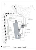
Figure 4: Location of trenches.
A.M. Hunt commenced excavation in 1972 (Areas A, C and D; Trial Trenches 1-3; 450m²) on behalf of the Avon-Severn Valleys Research Project (DoE-funded). Topsoil was stripped by JCB and Smalley back-acting excavators. The stripping revealed that ploughing had removed almost all floors, surfaces, spread layers and upstanding features, leaving a palimpsest of features cut into the gravel subsoil. Pits and evidence of structures were found in addition to the ditches, and an Iron Age date was postulated.
In July-August 1973 (1300m²) a second season was funded in the same way, with the director now being employed by Hereford and Worcester County Council. A large swathe (Area E) was cut across the site, linking the areas (A, C, D) opened in 1972 and exposing a substantial part of the interior of the enclosure.
In August-September 1977 a third season was funded almost entirely by the Manpower Services Commission, with the director now being employed by the Dorset Institute of Higher Education (from 1992 Bournemouth University). Soil stripping in the central area was done by a twin-engined wheeled box-scraper. Areas V, W, X, Y, Z, and Trenches T and U were excavated by hand, except for extensions to Areas Z and Y, and a deep trial trench (S), where back-acting excavators were again used. As the virtual absence of vertically stratified layers had been established in 1972, topsoil could be removed either by hand or machine, leaving a thin covering (40-60mm) of topsoil over the gravel surface. This thin covering was then removed by hand, to avoid disturbing features showing in the surface of the gravel. This surface was carefully trowelled and brushed to define features, which were subsequently totally excavated. In 1977 any hitherto unexcavated areas were sampled as extensively as possible in order to ensure that no substantial parts of the enclosure remained unexcavated. Excavation of the entrance was completed (Trench X), and a dense group of pits close to the entrance was further investigated (Trench V). In this last season prior to the destruction of the site, it was recognised that, while total excavation of the site was desirable, it was impossible within the limitations of the financial (and other) resources available. By the end of the 1977 season a total area of about 2500m² had been excavated, amounting to about one-third of the site.
Subsequently, watching briefs were carried out by C.I. Walker in both 1978 and 1984. Much later extensions to the quarrying in 1997 and 1999 were subject to a pre-determination evaluation and a watching brief respectively, but neither of these recorded deposits of any note. Reserves at both quarry sites are now exhausted and the area has, in the main, been restored to agricultural use, currently (2007) as a pasture field.
PREVIOUS
NEXT
CONTENTS
HOME
© Internet Archaeology/Author(s)
URL: http://intarch.ac.uk/journal/issue28/3/1.2.html
Last updated: Wed July 21 2010