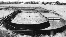

Figure 4: A 'U' bugle sheep yard. Note the race on the left of the image, and the tapering of the space created by the fences leading into this (the forcing pen) (NSWDPI 2004a).
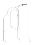
Figure 5: Plan of 'U' bugle sheep yard. (NSWDPI 2004b).
If Fences 1 and 2 were contemporary, a narrow 'corridor' would have been present between them. This would seem to be one of the "thin, functionally useless, triangular strips of land" that Russell uses to support his argument that "the multiplicity of fencelines within Platform 4 can perhaps be more logically interpreted as representing the remains of, not one, but at least two chronologically distinct phases of fenceline" (1996, 35). However, there are a number of problems with this interpretation. If the fences were constructed at different times it seems unlikely that the second fence was built to enlarge or reduce the size of an enclosure in this part of HP4, as the two are so close together. Pryor observes that "as a rule, farmers enlarge fields or paddocks by removing boundaries. Fields may thereby be coalesced; with good reason they are rarely extended by moving boundaries a few metres" (1996, 315). Space XV is less than one metre in width. This would suggest that, if one fence was built after the other, the first fence and its post-holes must have disappeared by the time the second was constructed. However, the two would appear to be related; they are roughly parallel for much of their lengths (Fence 1: 229-014, Fence 2: 230-038), and angles in the lines of both fences are close together (at contexts 014 and 038, the ends of the parallel lines). The shapes of these fences result in a triangular enclosure with an angle of approximately 45° leading in to the 'corridor'.
If the images in Visualising Access showing the control and RRA values for Configuration Group A (which includes the corridor) are consulted, one will notice that Space XV has one of the lowest control values for an exterior space in the configuration group, and provides a link between the exterior space with the highest real relative asymmetry — meaning that it is the least integrated into the system — (XIV) and two exterior spaces with a high level of integration (XIII and XVI). Thus, it is a space by which movement between a more 'private' area and 'public' areas can be controlled.
Such spaces are used today in sheep farming; they are referred to as 'races' and allow the flow of a large number of animals to be managed (NSWDPI 2004a). Examples from the Bronze Age are known; one of these is from stockyards at Storey's Bar Road, Fengate (Pryor 1996, 318). The dimensions of Space XV are approximately 13m by 0.75m, which corresponds with the specification given by the NSWDPI that "[t]he working race can be from 10m to 20m long and should be about 700mm wide" (2004a). In modern sheep farming, these races are part of a system of yards, which includes a holding area, a forcing yard, a working race, a drafting race and a receiving yard or yards. The forcing yard leads sheep into the races, and the drafting race allows an operator to assess each animal and decide where it should go. If the fence connecting Fences 2 and 3 was contemporary with the other fences, such an arrangement could have been present at HP4 (see Figures 6 and 7a and 7b). It is worth remembering that although the somewhat abstract images used in gamma-analysis treat HP4 as a two-dimensional system of spaces, it was in reality three-dimensional. As such, the heights of fences could have allowed humans to reach over them from one space into another. This would have been of great use to people using the fences to guide a substantial number of animals.


Figure 4: A 'U' bugle sheep yard. Note the race on the left of the image, and the tapering of the space created by the fences leading into this (the forcing pen) (NSWDPI 2004a).
Figure 5: Plan of 'U' bugle sheep yard. (NSWDPI 2004b).
The end of Space XV could have been used as a drafting race "[the drafting] race should be 3-3.5m long. If it is any shorter the operator does not have any time to inspect sheep for drafting; if it is any longer it tends to promote baulking along the race, interrupting sheep flow" (NSWDPI 2004a). The area I have suggested as a possible drafting race is slightly over 3.5m, but with the triangular end as shown in my reconstruction the working area is within this length. The orientation of the proposed race could also be seen to support my interpretation; it faces down the slope of the hill, which would have been a suitable area for the sheep to graze, particularly as they could be seen from the hut platform. The NSWDPI website states that "One of the reasons given for the efficiency of circular yards is that sheep flow back in the direction from which they have come — that is, back to the freedom of their paddock" (NSWDPI 2004a). It would have been possible to graze sheep on the hillside without the need for fences. Clutton-Brock writes that "sheep will maintain well-defined home ranges but they have no core area and do not defend a territory, whilst their social structure predisposes them to leadership by a herdsman" (1987, 55). While there is some risk that I am imposing modern cultural norms on the past, it does seem possible that during a period in which large-scale, elaborate 'community stockyards' were established (Pryor 1996) there would have been a great enough degree of shared knowledge for the behaviour of sheep to be taken into account when constructing farms. Information from phosphate analysis of HP4 would be of use in seeking confirmation of this interpretation.
Figure 6: Possible arrangement of fence lines and gates at HP4 (after Drewett 1982, 327, 335). Note the similarities in the arrangement of space between the northern area of this arrangement and the 'U' bugle yard in Fig. 5. Arrows and letters shown in blue represent the possible use of space as stockyards for sheep. H - holding area; F - forcing yard; W - working race; D - drafting race; R - receiving yard. [View static image]
© Internet Archaeology/Author(s)
University of York legal statements | Terms and Conditions
| File last updated: Wed Dec 7 2011