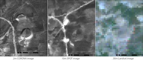
Figure 1: Comparison of Tell Qarqur, Syria, as it appears on CORONA, SPOT and Landsat satellite imagery. High resolution (2m) CORONA images make them far more valuable for direct detection of archaeological sites. Link to CORONA atlas
During the 1920s, soon after the first biplanes made their appearance in the skies above the fractured remnants of the Ottoman Empire, archaeologists working in the Near East began to recognise the phenomenal power of aerial photography to aid in the discovery of archaeological sites and to reveal landscape features which were not easily visible on the ground (e.g. Poidebard 1934; Schmidt 1940). Over subsequent decades aerial photography became a critical tool in European archaeology, used to document everything from Neolithic barrows of England to Roman field systems in the Balkans (e.g. Wilson 2000), but in the Near East World War II mostly put an end to such studies. As nations in the region achieved independence from colonial powers, aerial photography became a closely guarded strategic secret and few archaeologists had access to it. Beginning in the 1970s, civilian satellite imagery such as NASA's Landsat became available, capturing wavelengths of light across visible and infrared spectra, yet the coarse spatial resolution of these images reveal sites only as amorphous, pixelated spots—if at all.

Figure 1: Comparison of Tell Qarqur, Syria, as it appears on CORONA, SPOT and Landsat satellite imagery. High resolution (2m) CORONA images make them far more valuable for direct detection of archaeological sites. Link to CORONA atlas
In part thanks to the lobbying efforts of Robert McCormick Adams, Mesopotamian archaeologist and at that time Secretary of the Smithsonian, in 1995 President Clinton signed an executive order directing the declassification of photographic imagery acquired by the first generation of United States spy satellites, a system code-named CORONA (Day et al. 1998). The archive consists of more than 860,000 satellite images covering much of the world, dating from 1960-1972. CORONA images were acquired on large rolls of black-and-white film, and because no means of transmitting images remotely had yet been developed, canisters of film, once exposed, were ejected and parachuted to earth where they were intercepted in mid-air by a plane. The latest generation of CORONA imagery from the KH-4B missions, dating from 1967-1972, offers high spatial resolution (1.83m), allowing archaeological sites and features to be seen with great clarity in the best images (Figure 1). Moreover, these and other CORONA images were taken in stereo, so that the relief of the ground surface can be viewed in three dimensions, and it is possible to extract digital elevation data or topographic maps directly from the imagery (Altmaier and Kany 2002; Gheyle et al. 2004; Goossens et al. 2006; Casana and Cothren 2008; Galiatsatos et al. 2011). The potential of CORONA imagery for archaeology in the Near East was quickly recognised, and numerous researchers have since deployed these data in research projects (e.g. Kennedy 1998; Kouchoukos 2001; Philip et al. 2002; 2005; Challis et al. 2002-2004; Ur 2002; 2003; 2005; 2010; Casana 2003; 2007; 2008; Casana and Wilkinson 2005; Fowler 2004; Altaweel 2005; Wilkinson et al. 2006; Pournelle 2007; Beck et al. 2007; Hritz 2010).
Today, high-resolution satellite imagery produced by privately operated satellites such as IKONOS, Quickbird and GeoEye is readily available for viewing by anyone with an internet connection through GoogleEarth or similar mapping websites. Furthermore, if researchers purchase these commercial images, they offer even better spatial resolution, spectral coverage into near-infrared wavelengths, and highly accurate orthorectification. One might think that these modern resources would relegate the cumbersome, black-and-white images produced by CORONA satellites to a footnote in history. However, in the past several decades, the Near Eastern landscape has been radically transformed through widespread intensification and mechanisation of agriculture, the creation of massive reservoirs, and enormous population growth in urban areas. These developments have resulted in the devastation of the archaeological record. Entire ancient cities have been flattened, submerged, or built over, while traces of their associated roads, fields and canals have been obscured or completely erased. The terraforming of the Near Eastern landscape since the 1960s means that, in many regions, recent satellite imagery — even at very high resolution — reveals only a portion of the sites and features that were extant a few decades ago. Precisely because of its age, CORONA imagery preserves a picture of an archaeological landscape that, by and large, no longer exists.

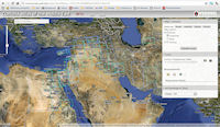
Figure 2: CORONA Atlas homepage
While the value of CORONA imagery is now widely recognised by Near Eastern archaeologists, raw, unprocessed images contain extreme spatial distortions that make it challenging to create maps from the images, to view them in GIS software, or to integrate them with other spatial datasets. These difficulties, combined with the sophisticated software necessary to work with the data, have meant that only a handful of specialists have made use of CORONA imagery. We report here on the results of a three-year effort funded by the National Endowment for the Humanities and the American Council of Learned Societies to make CORONA imagery accessible with the same ease that people now commonly use GoogleEarth (Figure 2). We also provide tools enabling researchers to download imagery for incorporation into their own projects and tutorials for more advanced applications, including stereo analysis and digital elevation model extraction. The CORONA Atlas Project has completed processing of more than 1200 images from across the Near East, and with the continuing support of NASA, we are currently exploring the extraordinary archaeological record preserved in these images. Our and other researchers' work with CORONA imagery is now transforming this resource, born of an effort to spy on enemy states in an era of tense militaristic stand-off, into a means to discover and document the cultural heritage of the very places that were once targets of intelligence gathering. Following some general background on CORONA (1.1 and 1.2) and comparisons with other aerial and satellite datasets (1.3 and 1.5), this article provides: an overview of our methods for correcting CORONA imagery; examples of the changing landscape of the Near East and its impact on the archaeological record; a sampling of archaeological discoveries that CORONA imagery has already made possible; and emerging applications of CORONA imagery in stereo analysis and topographic data extraction.
© Internet Archaeology/Author(s)
University of York legal statements | Terms and Conditions
| File last updated: Fri Sept 21 2012