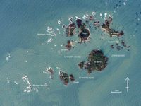
Figure 6: Annotated satellite image of the Isles of Scilly showing the principal islands of the archipelago. Used with permission (© NASA).
Case Studies:
Reconstructing the island landscape of Scilly
Prehistoric fishing and hunting on Scilly
Prehistoric wayfaring on Scilly
The Isles of Scilly are a small archipelago of granite islands located approximately 48km south-west of Lands End, Cornwall (Figure 6). Today, Scilly comprises around 200 named islands, although the vast majority of these are devoid of terrestrial vegetation and soil and project only a few metres above Mean Sea Level (MSL). The seven largest islands of the archipelago are: Annet, Bryher, Samson, St Agnes, St Martin's, St Mary's and Tresco. To the east and north of the archipelago, the Eastern Isles and St Helen's group form small clusters of islands and islets, while to the north-west and south-west are the infamous Northern and Western Rocks.
Figure 6: Annotated satellite image of the Isles of Scilly showing the principal islands of the archipelago. Used with permission (© NASA).
In any discussion of prehistoric island and coastal communities it is essential to first understand the relationship between archaeological sites and the ancient coastline. Ashbee (1974, 52) noted that the question of the submergence of Scilly is unavoidable in any study of the islands' prehistory. The effect of sea-level change and the presence of archaeological remains within the present-day intertidal zone has been noted since the mid-18th century (Borlase 1753). Various efforts have been made to define and model the drowned landscape of Scilly (Crawford 1927; Ashbee 1974; Fowler and Thomas 1979; Thomas 1985). Recent analysis and dating of intertidal deposits from Scilly have refined our knowledge and provided a comprehensive model for the archipelago's submergence (Ratcliffe and Straker 1996). A detailed interpretation and summary of these data has been provided elsewhere (Johns 2012; Robinson 2007).
Recently, Mortimer (2011) has refined the model for sea-level change on Scilly using new oceanographic data not previous available. Using established sea-level index points and bathometric data, alongside GIA data (glacial isostatic adjustment) and tidal amplitudes, generated within a palaeo-tidal model (Lambeck 1995; Neill et al. 2010; Peltier and Luthcke 2009; Uehara et al. 2006), Mortimer has been able to map 13,000 years of intertidal change on the Isles of Scilly (2011). The sea-level curve produced suggests a significantly slower rate of sea-level rise compared to that suggested by Thomas (1985), but slightly faster than postulated by more recent models (Ratcliffe and Straker 1996).
The sea-level curve produced demonstrates rapid increase in sea-level between 11,000 BC and 5,000 BC, with a marked decrease in the curve after 5,000 BC (Mortimer 2011, 19, fig. 3). The model also illustrates the relationship between changes in sea-level and the extent of terrestrial habitat and intertidal zone (Animation 1). In summary, as the sea-level rises the extent of terrestrial habitat decreases and the extent of the intertidal zone increases (Mortimer 2011, 28, figs 6 and 7).
Animation 1: 11,000 years of intertidal change on the Isles of Scilly (source: modified from Mortimer 2011, 20-24, figs 5a-5i)
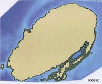
The model suggests that at the end of the last glaciation the archipelago may have consisted of a single landmass approximately 17km long and 8.5km wide stretching from the Western Rocks to the Eastern Isles and from Peninnis to Shipman Head. The coastline of this island would have been characterised by impressive cliffs and with very little intertidal zone. As sea-level rose, and perhaps by as early as 5,000 BC, submergence of low-lying areas led to the formation of a number of different islands. To the north, the modern islands of St Mary's, Bryher, Tresco, and St Martin's formed a single island, while to the south St Agnes, Annet and the Western Rocks constituted three smaller tracts of land. Intertidal areas may have been restricted to the southern half of the archipelago, concentrated within St Mary's Sound and perhaps connecting St Mary's, St Agnes, Annet and the Western Rocks at low spring tide (LST).
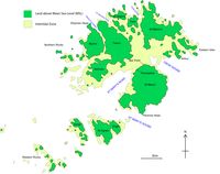
Figure 7: A reconstruction of the Late Neolithic/Early Bronze Age configuration of the Isles of Scilly (Source: Author).
During the late Neolithic and Early Bronze Age (c. 3000-1500 BC), the period of time under consideration in this article, the modern islands of St Mary's, Bryher, Tresco, and St Martin's formed one large island at LST, while to the south St Agnes, Annet and the Western Rocks constituted three separate tracts of land. The main geographical features that comprise this island landscape during this period are two large bays: the first to the east, between Bar Point and Arthur; and the second to the west between Pendrathen and Samson (Figure 7). To the north, small bays/inlets would have existed within the deep channels of Tean Sound. While changes in sea-level have altered the archipelago's coastline, the overall shape and configuration of the islands during prehistory need not be substantially different to that illustrated (Figure 7). In the last 1000 years the terrestrial landmass has remained reasonably stable while the extent of the intertidal zone has decreased. The significance of this work is that it allows us to explore temporal and spatial changes in the relationship between archaeological sites and the changing coastline of the archipelago.
Internet Archaeology is an open access journal based in the Department of Archaeology, University of York. Except where otherwise noted, content from this work may be used under the terms of the Creative Commons Attribution 3.0 (CC BY) Unported licence, which permits unrestricted use, distribution, and reproduction in any medium, provided that attribution to the author(s), the title of the work, the Internet Archaeology journal and the relevant URL/DOI are given.
Terms and Conditions | Legal Statements | Privacy Policy | Cookies Policy | Citing Internet Archaeology
Internet Archaeology content is preserved for the long term with the Archaeology Data Service (ROR). Help sustain and support open access publication by donating to our Open Access Archaeology Fund.
File last updated: Fri May 31 2013