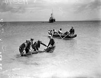
Figure 9: Islanders on Inisheer bringing a bullock out to Dublin built steamer, the Dún Aengus, for transport to Galway (31 May 1939). Used with permission. (© National Museum of Ireland, NLI Ref. INDH3344).
Case Studies:
Reconstructing the island landscape of Scilly
Prehistoric fishing and hunting on Scilly
Prehistoric wayfaring on Scilly
A landing place is a site that constitutes the interface between water and land from which boats may be launched or landed. There exist varying types of landing site, ranging from simple anchorage points and boat-launching sites through shipyards and simple harbours to major trading ports. What all these landing sites have in common is that they were created by people, for people using boats. Boats and landing sites are very closely related elements of the maritime cultural landscape (Ilves 2012, 94). Landing places and harbours are fundamental to coastal and island communities. They are at the centre of such communities and are thus a common focus and reference point for the location of settlements and the construction of monuments (Robinson forthcoming). In this respect, Ilves (2012) has argued that boats 'shape the shoreline', in that for coastal communities access to the sea, and thus the launching and landing of boats, is central to their daily life. Access to the sea is a central structuring principle within the lives of coastal communities around which other elements of their daily lives are constructed.
Landing places for small prehistoric boats required very little modification to the shoreline, as any sheltered bay or gently shelving beach, with some sort of access to settlements, may suffice (Parfitt 2004, 100). However, Ilves points out that this assumption has been used by many archaeologists to argue that it is impossible to locate archaeological traces of early and smaller landing sites (2012, 95). Within western Britain a number of attributes may be identified to assess the likelihood of whether a particular coastal locale could have been used as a landing place. Areas with cliffs and rocky shorelines would be avoided, as would areas with strong currents, exposure to wind and eddies. Preference would be given to sheltered bays with sandy gently shelving beaches (Figure 9).

Figure 9: Islanders on Inisheer bringing a bullock out to Dublin built steamer, the Dún Aengus, for transport to Galway (31 May 1939). Used with permission. (© National Museum of Ireland, NLI Ref. INDH3344).
However, we should not assume that landing places were openly accessible to all communities along a coastline, as access to the sea and its resources are not necessarily common property. On historical and ethnographical grounds, Durrenberger and Pálsson (1987) note that it is frequently assumed as natural that the seas and their resources have everywhere and always been common property. However, their work demonstrates that this conception is neither universal nor natural; it is not historically or ethnographically supportable (Acheson 1981, 280-81; Durrenberger and Pálsson 1987, 510; McCay 1978, 399). Landing a small boat on a coast would have been risky, especially during the winter season, and access to the sea would therefore have depended upon the availability of good landing sites. Access to the sea from the shore may have been controlled by particular coastal communities (Durrenberger and Pálsson 1987, 510). Such discussions of territoriality suggest that prehistoric landing places are not purely functional spaces, but invested with issues of ownership, access and identity.
As small prehistoric boats do not require any particular landing structures it is assumed that such features never existed in the archaeological record. Ilves (2012, 101) notes that the perception that no such structures existed during prehistory has led to a lack of systematic attempts to locate constructions or alterations along the shoreline. Ilves demonstrates the potential for such structures existing by reporting a number of prehistoric and historic examples from Poland and Scandinavia, where landing stages and mooring posts had been constructed to accommodate small boats (2012, 98-101).

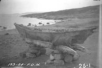
Figure 10: Umiaks are stored upon stands in order to protect them from dogs. Native umiak c.1924 on Cape Henry Kater, Baffin Island, Nunavut. Used with permission (© Library and Archives Canada, F.D. Henderson Collection, Ottawa, Ontario. PA-173743).
In the UK, the interpretation of timbers found in association with the North Ferriby boat site have been interpreted as part of a capstan for hauling boats onto the foreshore (Wright and Wright 1947; Wright 1978; 1986). This interpretation has been made through analogies between ethnographic parallels and recent beach capstans from Northern Europe. While the attribution of these timbers to the Bronze Age cannot be proven, it is assumed that the object is part of a single assemblage comprising discarded debris associated with the three major fragments of a plank-built boat reliably dated to the mid-2nd millennium BC (Wright 1986).

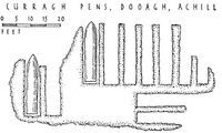
Figure 11: Plans of stone currach pens on Achill Island. Historically these pens were used to protect currachs from bad weather and animals. If skinboats were used in prehistoric times similar pens may once have been present along the coastlines of western Britain and Ireland. Used with permission (© Antiquity Publications Ltd, from Piggott 1954, 23, fig. 5).
The nature of landing sites is dependent upon the types of boat in use. Skinboats in particular can easily be damaged on rocky shorelines, and sandy beaches would be chosen in preference. Rather than being dragged onto the beach, skinboats would be unloaded in the shallows and carried up the beach beyond high water and stowed away. Skinboats would also need to be protected from damage by animals and the elements. Ethnographic information from the Arctic notes that skinboats, constructed of seal skin and proofed with blubber, are irresistible to animals, especially dogs. In the Arctic, kayaks and umiaks are therefore covered and stored on stands to protect them from birds and other animals (Figure 10). In Ireland, traditional animal hide currachs were stored, when not in use, within stone currach pens (Piggott 1954) (Figure 11). Within fishing communities, stands are frequently erected above high water to repair and dry fishing gear. Fishing nets and lines need to be washed and dried periodically as lines made from natural fibres and sinew are quickly encrusted with plankton and jelly fish particles, making the nets luminous to fish (Olsen 1982, 44). Historically, nets and lines are dried on racks and stands set above high water. Such structural features of landing places used by small boats would have existed in the past and they are essential elements of maritime and coastal life. The flimsy nature of such structures within, or immediately above, the intertidal zone may be problematic to identify archaeologically, but this should not deter us from looking for them. Admittedly, no such structures have been identified to date, but raising awareness of their potential presence may allow for their identification through the reinterpretation of shallow postholes/stakeholes and structures identified in past excavations.
Internet Archaeology is an open access journal based in the Department of Archaeology, University of York. Except where otherwise noted, content from this work may be used under the terms of the Creative Commons Attribution 3.0 (CC BY) Unported licence, which permits unrestricted use, distribution, and reproduction in any medium, provided that attribution to the author(s), the title of the work, the Internet Archaeology journal and the relevant URL/DOI are given.
Terms and Conditions | Legal Statements | Privacy Policy | Cookies Policy | Citing Internet Archaeology
Internet Archaeology content is preserved for the long term with the Archaeology Data Service. Help sustain and support open access publication by donating to our Open Access Archaeology Fund.
File last updated: Fri May 31 2013