Cite this as: Herzog, I. 2013 Review of Least Cost Analysis of Social Landscapes. Archaeological Case Studies [Book], Internet Archaeology 34. https://doi.org/10.11141/ia.34.7
Review of: White, D. and Surface-Evans, S. (eds) 2012 Least Cost Analysis of Social Landscapes. Archaeological Case Studies. Salt Lake City: University of Utah Press. ISBN: 978-1-60781-171-8. 268 pages.
Introduction
The application of least cost analysis by archaeologists in Northern America and Europe has increased considerably during the last decade, and the readily available tools for this purpose have led to a much wider interest in the application of this set of techniques for research.
The volume under review mainly presents the papers held at the symposium "Tracing trails and modeling movement: Understanding past cultural landscapes and social networks through least cost analysis". This symposium was organised by the editors of the volume at the 74th Annual Meeting of the Society for American Archaeologists in Atlanta in April 2009. As the book, which contains 14 chapters by 18 - all US-based - contributors, took three years to appear, inevitably some references to more recent publications on the subject of least cost analysis (LCA) were not included.
The volume starts with an introduction and fairly basic applications of LCA, i.e. a methodology to reconstruct patterns of human movement in space; this is followed by two parts, each consisting of three papers with new ideas for LCA applications or more advanced methods for calculating LCA. The final part presents three papers discussing different aspects of LCA raised in the first parts of the volume and general issues of methodology.
In the introductory chapter the editors describe the intention of the book. It is designed "to be a guidebook for archaeologists interested in using LCA to answer behavioral questions". They explain that LCA is based on the assumption that humans tend to economise many aspects of their behaviour. They emphasise that LCA is not an end in itself but a tool which should be used properly. This ambitious goal is however not necessarily matched by the contributions to the volume, in this reviewer's eyes. Some examples are presented here to show that LCA requires a clear understanding of its methodology and that outcomes need to be validated.
Isotropic and anisotropic models
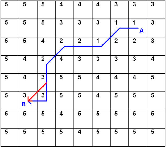
The methodology of LCA and some terms are explained in the introductory chapter. An alternative introduction to LCA can be found in Chapter 13 by Kantner. In standard GIS software, least-cost site catchments and least-cost paths (LCPs) are calculated on the basis of raster cells with each cell storing the costs of movement through this cell. This is the isotropic case, i.e. where the direction of movement does not influence the costs to be paid. In Chapter 1, an image illustrates by a simple example that the least-cost path in an isotropic grid can deviate significantly from a straight line. Another simple example is shown in Chapter 8 by one of the editors: the path in the upper half of fig. 8.4 is not an LCP, as a shorter path accumulating fewer costs exists (Figure 1).
Figure 1: fig. 8.4 redrawn. According to Surface-Evans, the blue path is the LCP connecting A and B, but replacing the final two steps by the red path section accumulates less cost. The total cost of the final two steps on the blue path is 6, whereas the diagonal red path section has a cost of 3*1.4 = 4.2.
An isotropic model is adequate for modelling walking costs on a plain covered partly by tracks, 'desert pavements', loose sand, gravel or vegetation like grass or thick brush. I would therefore take issue with Scott Branting (Chapter 12) who states that "Isotropic models are those that deal with space as if it were a featureless plain without any topographic or other impedimental barriers" (p. 218).
Nearly all archaeological case studies applying LCA calculate costs on the basis of slope, and slope is anisotropic, i.e. the direction of the movement plays an important role. However, information on how to compute anisotropic LCPs is missing from both the introductory chapter and Chapter 13. In fact many case studies in the book apply the ESRI ArcGIS Path Distance (http://webhelp.esri.com/arcgisdesktop/9.2/index.cfm?TopicName=Path_Distance) that is capable of anisotropic calculations; but configuring this procedure is quite complicated as four different input raster layers (in_cost_raster, in_surface_raster, in_horizontal_raster, in_vertical_raster) and several additional input parameters are supported. The editors note that with anisotropic LCP calculations, the LCP connecting A and B may differ depending on the travel direction. Moreover, they mention that five contributions in the book explore anisotropy but only one chapter shows maps with different LCPs connecting two locations. It is likely that in most cases people used one path in both directions, but this is not discussed. In their simulation study (Chapter 9), Ullah and Bergin create cost surfaces that do not include the costs of returning to the village. As a consequence of modelling site catchments this way households in the simulation avoided high-slope areas only if the inhabitants had to walk up the slope; but the costs of returning are probably more important because additional load (harvest, milk, wool) has to be carried. Ignoring the costs of returning to the village could well invalidate the results of the complex simulation.
In fact, only White in Chapter 11 gives details about how anisotropic calculations are implemented in his case study. Kantner notes in Chapter 13 that the majority of archaeological LCAs apply an isotropic model. He attributes this situation partly to the fact that "until recently, most software packages did not readily accommodate anisotropic modeling" (p. 229), and therefore archaeologists assumed that isotropic modelling is appropriate. In my opinion, the main problem is that archaeologists apply LCA because it is popular to do so and user-friendly GIS software that does not require knowledge of the algorithms implemented is available. Kantner writes"users can apply cost-path functions without full knowledge of the geographic information science on which the functions are based" (p. 225). Even those creating LCA software are not necessarily aware of the drawbacks of the methods applied.
The Dijkstra algorithm
Most GIS software aiming to compute the LCP in a raster grid is based on the Dijkstra algorithm. This algorithm identifies the globally optimal path between a source location and all other locations in a graph (Cormen et al. 2001, 595-99). In the introductory chapter, the editors call this a greedy algorithm, as does Kantner in Chapter 13. But, as Kantner notes, a greedy algorithm chooses the locally optimal solution at each step and therefore may not produce a globally optimal result (Cormen et al. 2001, 370). This reflects a widespread misconception that LCA software does not compute the globally optimal path - but, if Dijkstra's algorithm is implemented properly, no other path connecting the source with the target location accumulates fewer costs. In some chapters, their authors discuss the fact that people are more likely to choose quite different paths when travelling over unknown landscapes than they do when moving over familiar terrain. Rademaker and his colleagues (Chapter 3) as well as Anderson (Chapter 14) expect that new arrivals would try to identify routes involving efficient movement over short distances, and for this reason, a greedy algorithm might be appropriate in such situations. But this aspect is not discussed further in the book.
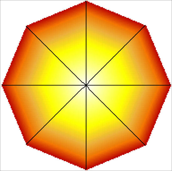
The main problem is that Dijkstra's algorithm was designed for graphs. So the raster data (the digital elevation model and/or the cost grid) has to be converted to a graph somehow, and a way to do this is explained in Chapter 11: each raster cell is linked to its neighbouring cells. The LCA results depend on the number of neighbours considered (Harris 2000; Herzog 2013c; Wheatley and Gillings 2002, 157-59), but this issue is not discussed in any of the contributions. However, several LCP results presented in the book clearly show the disadvantage of considering only eight neighbours (see Figure 2): many of the LCPs shown in Chapters 5 and 7 consist of long stretches in one cardinal (north, east, south, west) or subcardinal (northeast, southeast, etc.) direction or vice versa (figs. 5.5B, 5.6, 5.7, 5.8, 7.4, 7.5); changing the orientation of the coordinate system by a few degrees could result in completely different paths.
Figure 2: Site catchment resulting from an isotropic raster with constant cost values, if only eight neighbours are considered. The black lines mark paths where progress is most efficient. These paths coincide with straight lines in the cardinal and subcardinal directions.
Digital elevation models
Slope is used for computing costs in all case studies, and therefore accuracy and resolution of the digital elevation model (DEM) is important. Different DEM resolutions are used in the case studies presented, ranging from 5 m (Chapter 9) to 180 m (Chapter 10). Rademaker and his colleagues (Chapter 3) reconstruct paths on the basis of the SRTM (Shuttle Radar Topography Mission) elevation data (90 m cell size), and they describe a "steep-walled canyon" with a "~10-m-wide slot" in their study area. So the DEM selected cannot represent this canyon properly. DEM resolution is also discussed in the chapters of the final part of the book: according to Kantner, many more low- or no-slope cells are present in a DEM when the resolution is increased (and this creates problems with the inadequate cost function proportional to slope). But generally, the proportion of steep-slope cells decreases with increasing the cell size (Smith et al. 2007, 260-61). Discussing resolution of the DEM, Anderson observes that for analysing pathways over great distances, "1-km resolution would likely be fine" (p. 242). But he also notes that technical progress nowadays allows us to obtain high resolution geographic data and to record archaeological find locations with high precision. Branting (Chapter 12) discusses the problem of reconstructed paths crossing obstacles without paying adequate costs, if the cell size of the DEM raster is too large. With his own case study in mind, he recommends applying a vector approach. But his model case study is exceptional because it deals with an urban area where all routes could be recorded. In an urban area, obstacles channel the routes to a limited part of the total area studied, and these paths can be modelled by vectors. Most archaeological case studies are not set in built environments, and in open landscapes these limitations do not exist.
Discussing cost models
For LCA calculations a cost model is necessary, and the editors' introduction mentions the two different currencies used in most archaeological LCA studies - either travel time or energetic expenditure - but it does not discuss the advantages and disadvantages of the two approaches. Kantner observes that "cost-path studies in archaeology have expended little effort exploring which currency humans most likely want to optimize" (p. 228) and merely lists the formulae for different cost functions without discussing them; and the book as a whole does not contain a detailed analysis of cost functions as in Herzog (2013a). The editors reassure us that all cost models used in the case studies are correct: "the authors in this book perform LCA in very different ways. This demonstrates that the correct application of LCA greatly depends on the archaeological question that is being addressed" (p. 1). But reading the book carefully, some disagreements can be detected. For instance, Rissetto (Chapter 2) applies a cost function proportional to slope in degrees but Kantner explains that slope is "a terrible proxy of movement costs across flat or nearly flat terrain" (Chapter 13, p. 227) because flat surfaces have a slope of zero (cf. Herzog 2013a). Another example is Rademaker and his colleagues' use of Pandolf's formula (Chapter 3). This is problematic because the formula assumes that pedestrians walk at a constant speed irrespective of slope; moreover, it is based on experiments with a slope range of 0 to 12%, and hence this formula is only appropriate for moderately ascending terrain. In Chapter 11, White notes with reference to Pandolf's formula: "Walking downhill produces significantly negative cost estimates, which suggests that a traveler could recharge by walking in this direction […]. Since downhill walking still requires effort, the model is not entirely useful in this situation" (p. 194).
Most case studies use fairly simple cost models, often focusing on slope only. But Anderson (Chapter 14) reminds us that other aspects "such as other human settlements, vegetation and terrain conditions, mountain passes, fords, water bodies"(p. 241) constrain movement too. Kantner has reservations about the utility of complex models because they require a sensitivity analysis of each variable included, especially if arbitrary costs are assigned to these. Some authors in other publications recommend refining a model successively if necessary after comparing the paths based on the simple model with the known or expected paths (for references see Herzog 2013c). An example for a cost model beyond slope is presented by Livingood (Chapter 10): the costs of overland travel are derived from Tobler's cost function, and this is combined with time penalties for crossing waterways or switching to canoe travel; the time needed for canoe-travel is estimated on the basis of historic and modern canoe speeds adjusted to the current. In her analysis of the Maya site of Copán, Honduras, Richards-Rissetto (Chapter 7) also uses a complex cost model. She combines an urban DEM with a friction surface assigning value 0.9 for roads, 3 for streams (quebradas), and 999 for reservoirs and structures. But unlike Livingood, there are no reasons given for her cost estimates, and no validation of the LCA results.
Networks
Hudson (Chapter 6) and White (Chapter 11) aim to reconstruct route networks which is more complicated than calculating LCPs (Herzog 2013b). Different models for network reconstruction exist; the one Hudson applies is simply the model implemented in the GIS software used. Yet there is a huge difference between a network minimising the total of all route lengths and another network that minimises the costs of movement to all other locations. White creates a network by constructing, for each location provided, five LCPs leading to the closest neighbours (closest in terms of energy consumption); the resulting network reconstructions consist of several unconnected components, and often the shortest path in the network between two nearby locations is considerably longer than the direct shortest path. If the objective is to reconstruct the paths to the nearest neighbours, an approach based on least-cost triangulation avoids the drawbacks of the five nearest neighbour method applied in this study (Herzog 2013b).
Validating or believing the results?
Seven of the eleven case studies in the volume do not present any validation of results, and this is a main drawback of the book even though the importance of ground-truthing is discussed in the chapters of the final part. Branting lists seven problems in LCA, with Problem no.1 being the fact that LCPs do not necessarily reconstruct real paths. Therefore verification of the cost model selected is required, a fact also emphasised by Kantner who underlines the importance of empirically testing the least-cost models. It is therefore surprising not to find such tests in his case study. Anderson praises the "field efforts of several of the authors in this book" that "involved checking routes and looking for sites in difficult and sometimes dangerous terrain" (p. 242).
Even if there is some agreement between known path sections and reconstructed routes or if new sites are detected close to LCPs, this does not necessarily mean that the best model was applied. Varying the parameters of the model might result in a better fit to the archaeological evidence and provides an analysis of the stability of the LCP results. Some systematic variation of the parameters can only be found in the contribution by Rademaker et al. (Chapter 3). Few authors experiment with several cost functions, mostly by applying the inadequate ArcGIS default (costs proportional to slope) and some other cost function that is somewhat more appropriate.
There are indications that the cost model chosen was not implemented adequately in some case studies. For instance, Phillips and Leckman (Chapter 4) attempt to model water transport in the desert of New Mexico by presenting LCPs with long detours and small-scale curves in the Doña Ana part of the study area. According to Google Earth, there are no large jumps in elevation in this area; thus, with the cost function selected, fairly direct LCPs are to be expected. In a similar vein, Surface-Evans (Chapter 8) notes that something is wrong with her least-cost catchment calculations: "Although the Ohio River was weighted the equivalent of the steepest slope […] this technique was not entirely successful" (p. 142). The site catchments in fig. 8.8 create the impression that crossing the river is as easy as walking on flat terrain.
If the cost model is inadequate or not implemented properly, the LCA outcome cannot be trusted, a fact not addressed by the editors of the book or by Anderson in the final chapter (Chapter 14). Most of Anderson's comments relate to archaeological aspects of the data collection and analysis (sites indicating the presence of old roads; bias introduced by sample size or locations, extent of survey coverage, prevailing landscape characteristics; evidence for contemporaneity of pathways; use of lithics in addition to pottery; obstruction to access and visibility due to built features like palisades; importance of water travel; impact of regional political geography) and reflect the author's rich experience of surveying American landscapes and analysing archaeological data. Anderson emphasises the impact of landscape change on the LCA result and lists the contributions that took this aspect into account, i.e. rather few.
Images
The book contains greyscale images in the contributions and a separate section with 14 colour plates on eight pages. With 14 chapters in the volume, one colour image per chapter might be expected, but the number of colour images per contribution varies between zero and three; unfortunately the plate numbering or captions do not state clearly to which chapter a plate belongs. Some of the plates could have been presented without loss of information as greyscale images (e.g. pl. 2, 6, 7), and some greyscale images would have benefitted from colour. Finally, some images have suffered in reproduction or could be more informative (e.g. fig.4.1 which does not show the topography used for cost calculations).
These details aside, some images are problematic. Something seems to have gone wrong with the scale bars in fig. 9.5: the diameter of the largest inner site catchment corresponding to a walking time of 2 hours is less than 2 km. As for fig. 10.1, it should be a map of 45 mounds, but only 20 symbols indicating mound locations are shown. Hardly any overlapping symbols are expected because only four of the Euclidian distances between mounds are less than 5 km (fig. 10.2). In Hudson's chapter (Chapter 6) two communities, Lion Mountain and Gallinas Springs, are compared but, while Lion Mountain is labelled in figs. 6.2 to 6.4, these figures do not indicate the location of the site of Gallinas Springs situated in the east of the study area shown on fig. 6.1.
Beyond LCA
To conclude, the book could have benefitted from more careful editing, especially casting a more critical eye on the applications of LCA techniques which, in my opinion, are inadequately applied in some cases. Most of the contributions are to a large extent exploratory, in the sense that ground-truthing was not carried out.
The criticisms in this review are offered in a constructive spirit: to convince readers that LCA is a powerful analytical tool but that it is not quite as easy, as stated by Anderson, to quickly calculate travel costs with weighting terrain and cultural factors as appropriate. This does not mean that you should not read the book, because most chapters are inspiring and contain some new and valuable ideas. Among them, Surface-Evans (Chapter 8) presents a new idea for identifying corridors of least costs between two locations (source and destination): the two cost surfaces for the source and the destination are added, so that corridors of low cost can be identified by selecting the raster cells with the lowest 10% of this cost surface. Nolan and Cook (Chapter 5) do not just connect dots on the map but analyse the economic background of trade routes by applying a model focusing on differences in harvest returns. Space syntax is often applied to analyse urban areas, whereas LCA is mostly used in rural areas, and Richards-Rissetto (Chapter 7) tries to integrate these methods for analysing a semi-urban landscape. Ullah and Bergin (Chapter 9) combine the landscape dynamics approach of GRASS GIS with an agent-based simulation for an agro-pastoral economy, taking erosion-deposition phenomena and vegetation succession dynamics into account. These contributions show pathways to future research rather than perfect methods. Finally the last three chapters start a discussion on assessing the quality of LCA case studies and raise some important questions that are helpful for those planning to apply LCA in the future.
Bibliography
Cormen, T.H., Leiserson, C.E., Rivest, R.L. and Stein, C. 2001 Introduction to Algorithms, 2nd edition, Cambridge (MA) and London: MIT Press, McGraw-Hill Book Company.
Harris, T. 2000 'Moving GIS: exploring movements within prehistoric cultural landscapes using GIS' in G.R. Lock (ed) Beyond the Map. Archaeology and Spatial Technologies, Amsterdam and Oxford: IOS Press. 116-23.
Herzog, I. 2013a 'Theory and practice of cost functions' in F. Contreras, M. Farjas and F.J. Melero (eds) Fusion of Cultures. Proceedings of the 38th Annual Conference on Computer Applications and Quantitative Methods in Archaeology, Granada, Spain, April 2010, British Archaeological Reports International Series 2494, Oxford: Archaeopress. 375-82.
Herzog, I. 2013b 'Least-cost networks' in G. Earl, T. Sly, A. Chrysanthi, P. Murrieta-Flores, C. Papadopoulos, I. Romanowska and D. Wheatley (eds) CAA 2012. Proceedings of the 40th Annual Conference of Computer Applications and Quantitative Methods in Archaeology Southampton, 26-30 March 2012, Amsterdam: Pallas Publications. 240-51.
Herzog, I. 2013c 'The potential and limits of Optimal Path Analysis' in A. Bevan and M. Lake (eds) Computational Approaches to Archaeological Spaces, Walnut Creek (CA): Left Coast Press. 179-211.
Smith, M.J. de, Goodchild, M.F. and Longley, P.A. 2007 Geospatial Analysis. A Comprehensive Guide to Principles, Techniques and Software Tools, Leicester: Matador.
Wheatley, D. and Gillings, M. 2002 Spatial Technology and Archaeology. The Archaeological Application of GIS, London and New York: Taylor & Francis.
Internet Archaeology is an open access journal based in the Department of Archaeology, University of York. Except where otherwise noted, content from this work may be used under the terms of the Creative Commons Attribution 3.0 (CC BY) Unported licence, which permits unrestricted use, distribution, and reproduction in any medium, provided that attribution to the author(s), the title of the work, the Internet Archaeology journal and the relevant URL/DOI are given.
Internet Archaeology content is preserved for the long term with the Archaeology Data Service (ROR). Help sustain and support open access publication by donating to our Open Access Archaeology Fund.