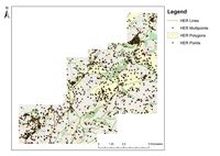
Figure 4: HER data entries for study area (data courtesy of GCC).
The Gloucester HER reveals a rich and varied archaeological landscape (Figure 4). There are 3069 individual sites, find spots and areas of archaeological significance currently recorded.
Figure 4: HER data entries for study area (data courtesy of GCC).
Early human activity is evident, with several barrows and long barrows of varying preservation located throughout the area. Long barrows are extremely common monument types throughout the Cotswolds (Janik et al 2011, 18). Specific, noteworthy examples within the project extent include the Randwick long barrow, Emma's Grove round barrows and the Climperwell round barrows (HER numbers: 350, 166 and 149). Other significant features include a possible Neolithic promontory enclosure known as Birdlip Camp or Peak Camp, still visible as earthworks although truncated by later quarrying (Darvill 2011, 67). Another site possibly used concurrently with Peak Camp is the Neolithic causewayed camp at Crickley Hill, probably first occupied in approximately 2500 BC. Excavation has demonstrated several phases of occupation at the site, evolving from causewayed camp to enclosure with a substantial continuous ditch, and was reused in the early Iron Age with at least six long houses present (Finberg 1975, 37; Thomas 1999, 41). Other significant Iron Age sites are present, most notably the hillforts at Painswick, Leckhampton and Haresfield Beacon (Moore 2006, 73-5).
The hinterlands of the nearby Roman legionary fortress of Glevum (Gloucester) forms a large part of the study area. The fortress was founded in 67 AD but later abandoned and established as a colonia towards the end of the 1st century AD (Copeland 2011, 40, 62). Sizable Roman settlement is also evident, most notably the villa site at Great Witcombe (Copeland 2011, 121). Significant Roman transport routes are also apparent, as Ermin Street laterally transects the study area, through the Cotswolds from Cirencester to Gloucester (Copeland 2011, 46). Alongside Ermin Street, the best evidence for non-villa Roman rural settlement is the site at Birdlip Quarry. The site comprises a farmstead with rectangular ditched enclosures containing at least one building. Consequently, this site seems untypical of Roman roadside settlement, which usually consists of strip buildings fronting a road (Holbrook 2006, 103). Roman industrial activity is also evident in the form of the stone quarry at Brimpsfield, near Manless Town (Rawes and Gander 1978, 79-82).
Settlement character in the Cotswolds becomes increasingly nucleated from the 8th century onwards (Dyer 1987, 167). This increasing nucleation is demonstrated through the town settlements of medieval origin present at Painswick and Stroud. However, there is evidence of settlement shrinkage or desertion at Manless Town, Overtown, Stockwell and Syde deserted medieval villages (DMV), and the shrunken settlements at Coppers Hill and a site south-west of Leckhampton Church. There is also some possible DMV sites at Bidfield (HER Number: 3764) and one site, identified by LIDAR, at Pitchcombe (HER Number: 3433).
Exploitation of the limestone-rich geology of the area continues, with stone quarrying evident near Painswick believed to date from the medieval period or earlier. Other industrial activity, beginning at least by the Norman Conquest, is the introduction of various milling operations to the area (Bowden 2006, 180).
Religious houses within the area include Prinknash Abbey, formerly in the possession of St Peters Abbey, Gloucester. Some parts of the structure date from at least the 14th century, but most of the buildings were constructed or rebuilt around 1514-19 AD (NMR: SO81 SE7). Extensive classic open field systems are extant throughout Gloucestershire; within the project area extensive medieval and post-medieval plough-lands exist in the Painswick Valley, possibly adapted from earlier prehistoric field systems (Bowden 2006, 177).
The castle sites of Castle Goodwyn, Painswick, Brimpsfield and Miserden provide the strongest evidence for medieval military activity. Also evident is the creation of several deer parks during this period near Brimpsfield, Painswick and Coberley.
Milling operations and quarrying continue throughout the post-medieval period, with numerous post-medieval mills and quarry sites recorded by the HER. The mills supported the cloth industry until its decline in the mid-19th century, and subsequently mill operations diversified into saw-milling, pin-making, and brewing. Nevertheless, mill operations continued to decline throughout the 20th century (Baggs et al. 1976, 70-9). Settlement in the area during the 19th century has been defined as generally low density, consisting of small hamlets, hamlets and small villages (Lowerre et al. 2011).
There are several WW2 airfields in the surrounding area and consequently several heavy anti-aircraft, searchlight batteries and bombing decoy sites are known to exist within the project area, coupled with two WW2 military camps at Ullenwood and Badgeworth (HER Numbers: 3035 and 3504).
Presently, there is little large-scale non-agricultural industry in the area (Janik et al. 2011, 14). However, the area has a long tradition of stone quarrying, exploiting the limestone-rich escarpment, but most quarrying in the area is small scale and has had little impact on the current landscape, although some areas of the escarpment exhibit pockmarks and scarring resulting from stone extraction (Janik et al. 2011, 14).
The Historic Landscape Characterisation (HLC) of the area details the major surviving components of the historic landscape. The HLC identifies several significant landscape types, including A1rm, A2, and L1, comprising 31% of the current landscape within the study area. These types are broadly characterised as irregular enclosures. Smaller areas, each comprising approximately 10% of the study area, are C1, consisting of surviving early woodland, and B4r, categorised as less regular organised enclosure of former unenclosed pasture.
Internet Archaeology is an open access journal based in the Department of Archaeology, University of York. Except where otherwise noted, content from this work may be used under the terms of the Creative Commons Attribution 3.0 (CC BY) Unported licence, which permits unrestricted use, distribution, and reproduction in any medium, provided that attribution to the author(s), the title of the work, the Internet Archaeology journal and the relevant URL/DOI are given.
Terms and Conditions | Legal Statements | Privacy Policy | Cookies Policy | Citing Internet Archaeology
Internet Archaeology content is preserved for the long term with the Archaeology Data Service (ROR). Help sustain and support open access publication by donating to our Open Access Archaeology Fund.
File last updated: Wed Oct 23 2013