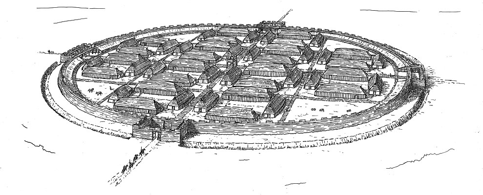
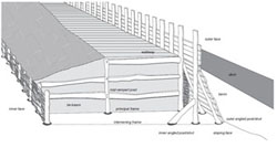
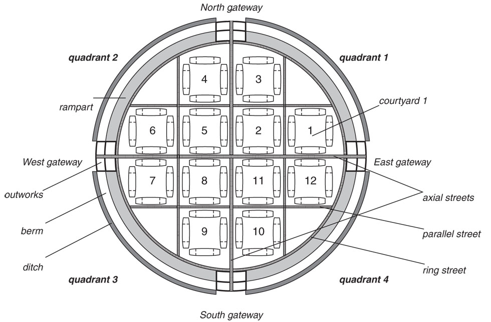
The circular fortress is one of the largest Viking-age monuments in Scandinavia, with an internal diameter of c. 240m (Figure 3). The c. 8m wide circular rampart was constructed of turf and spoil from the ditch, forming alternating layers of humus, turf, and masses of chalk, clay or sand subsoil (Ulriksen 1995); it was strengthened by internal timber structures and an outer cladding of wood (Figure 4).
Four entrance gates were orientated to the principal compass points. Reassessment of the data from earlier excavations has revealed that the gates did not form narrow tunnels through the body of the rampart, as suggested in previous reconstructions (Olsen and Schmidt 1977, 83). Instead the rampart, with its timber construction, was broken by a much wider entrance and had a broader interruption of the ditch in front of it (Figure 5). A palisade across this area formed an outer gateway, which likely acted as a barbican.
Two axial streets between the gateways divided the interior of the fortress into four quadrants. At the centre of the fortress, where these streets met, a substantial posthole was found at each of the four corners of the street crossing during excavation. Similar features were found at analogous fortresses at Trelleborg and Fyrkat (Nørlund 1948). It is difficult to understand them other than as the remains of a structure raised over the street. Schultz suggested in one of his notebooks that the posts at Aggersborg supported a permanent tower or gateway-building (Schultz 1949).
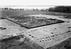
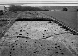
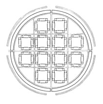
Each of the four quadrants of the fortress is believed to have accommodated 12 large wooden buildings, each c. 31.5m long, strictly arranged in groups of four around square courtyards (Figure 6). The whole arrangement is laid out with meticulous geometric accuracy. The ramparts and axial streets are currently marked out on the ground by low earthworks constructed in the 1990s (Figure 7).
A large body of finds material was collected during the excavations but, owing to a lack of clear stratigraphic separation from the pre-fortress settlement, only a few rather uncharacteristic objects can be associated with the fortress with any certainty.
Aggersborg belongs to a group of at least four closely related earth and timber fortresses, the so-called 'Trelleborg' type fortresses (Figure 8). They mirror elements of Aggersborg's plan, including the precise, circular layout, the timber structures of the earthen ramparts, the crossing axial streets, and the characteristic wooden buildings arranged in regular courtyards (Olsen and Schmidt 1977; Roesdahl 1987; Dobat 2009). The first example of these fortresses was excavated at Trelleborg, Sjælland, in 1934-42 (Nørlund 1948). Trelleborg comprised sixteen almost identical buildings within the circular rampart (136m in internal diameter), and another fifteen similar buildings, positioned in a radial formation behind a less-substantial outer rampart (Figure 9). Fyrkat, in Jutland, was built to the same design as Trelleborg's inner fortress, albeit slightly smaller (120m in internal diameter) (Olsen and Schmidt 1977).
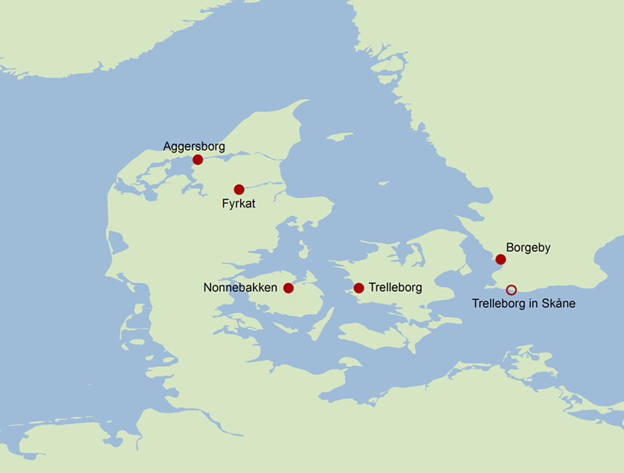
One or probably two further sites relate to this group of geometric ring-fortresses. Nonnebakken, in Fyn, though badly disturbed, has been shown by a series of small-scale excavations to share the circular layout, V-shaped ditch and timber construction of the Trelleborg group, and to be almost exactly the same size as Fyrkat (Arentoft 1993). Borgeby, near Lund in Skåne, has seen only provisional investigation, but also appears to share a similar rampart construction (Svanberg and Söderberg 1999). A further ring fortress near the city of Trelleborg in Skåne is also considered a close relative of the group; however, its layout does not show a strict geometric plan and it does not share the specific timber construction of the rampart seen in other fortresses in the group (Jacobsson 1995, 54; 1999, 147; Olesen 2000).
 b)
b)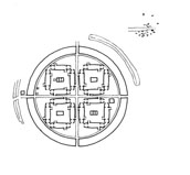 c)
c)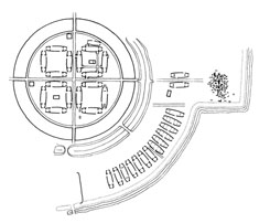
Artefacts found in association with the fortress features at Aggersborg (mainly from pits, which are closely associated with the fortress), including sherds of early types of Baltic ware pottery, together with the absence of characteristic 11th-century artefact types in the fortress area, date the structure to the late 10th century. This date is consistent with those obtained for Trelleborg and Fyrkat: timbers from these sites have been dated by dendrochronological tests to c. AD 980 (Bonde and Christensen 1982). Nonnebakken and Borgeby have also yielded finds that indicate activity in the late 10th century (Arentoft 1993; Svanberg and Söderberg 1999).
The scale of the Trelleborg-fortresses, their striking similarity, and their distribution across landscapes from Jutland to Skåne mark them as achievements of a supra-regional power, most likely relating to a ruler of the early kingdom of Denmark. Their date almost certainly places their construction during the reign of King Harald Bluetooth. The strict planning and management, geometric designs and monumental dimensions that characterise the fortresses are also seen in other contemporary Danish monuments associated with Harald: a monumental bridge at Ravning Enge, south of Jelling, the linear defence dyke at Kovirke in Schleswig, and the large burial mounds and recently discovered palisade enclosure at Jelling (Roesdahl 2002; Jessen et al. 2011). Like the ring fortresses, these monuments are generally accepted to have been royal strongholds and manifestations of power, constructed in a comprehensive building programme over a period of only a few years.
The most pertinent evidence relating to the function of the fortresses is provided by artefact finds from all three sites, and by the graves found at Fyrkat and Trelleborg. The artefacts include evidence of specialised production, including comb-making and non-ferrous metalworking, but only a modest number of weapons. While some of the dead at Trelleborg showed evidence of a violent death – including thirteen men buried in a mass grave – the graves also included women and children (Nørlund 1948; Roesdahl 1977). Burial rites at Fyrkat suggest cultural and religious diversity (Roesdahl 2004), and recent strontium-analysis of tooth enamel from graves at Trelleborg suggests a non-local origin for some of those buried here (Price et al. 2011). The fortresses would thus appear not to have served exclusively as military camps, but to have housed a settled population, and to have served as the loci for a wider range of specialised activities.
The purpose of the fortresses is open to question. An early suggestion (Nørlund 1948, 161f) that they were training camps for Swein Forkbeard's Viking armies, which conquered England in the early 11th century, has been abandoned on chronological grounds based on the dendrochronological dates. Two main models have since prevailed: one sees the fortresses as administrative centres in a state-formation process (Christensen 1969, 251f; Christiansen 1971; Randsborg 1980, 99f; Dobat 2009); the other as a defensive measure provoked by external aggression, especially from Germany during the reign of Otto II (Roesdahl 1984, 68f; L.C. Nielsen 1990, 170; Olsen 1999, 104). The two models are not mutually exclusive, and are difficult to separate on archaeological grounds, since both would imply a large measure of military power, centralised command and concentration of resources.
The Trelleborg fortresses saw only a short period of use, and all seem to have been abandoned well before AD 1000 (Roesdahl 2002; 2012; Dobat 2009). Their short use-life has been seen as possible evidence of rebellion – perhaps as a reaction against the exceptional use of power, to which the fortresses and other building-projects may bear witness (Roesdahl 1987; Sawyer 1988, 226ff). The possibility of an external cause is supported by the fact that the aggression of the Ottonian realm against its northern neighbours, which is recorded during the 970s, ceased when Otto II died in 983 and was replaced by the child regent Otto III – apparently coinciding with the abandonment of the Trelleborg fortresses (Roesdahl 2012, 349).