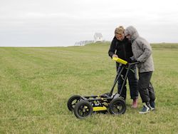
Figure 18b: Helen Goodchild conducting gradiometer survey in the Aggersborg fortress area. In the background the church and the reconstructed rampart are seen. View towards N. Photo: S. Sindbæk
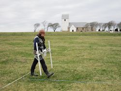
Two seasons of geophysical survey were conducted in 2011 and 2012 using gradiometry and ground-penetrating radar (Figure 18). Figure 19 shows the location of the survey areas; the survey grids were laid out with centimetre-accurate GPS by Jan Slot-Carlsen, Aalborg Museum, based on an array of 30 x 30m grids, orientated on the standard Danish National Grid (UTM sys 32ed50). Fluxgate gradiometry was chosen as the primary technique owing to the nature of the site features, as well as offering the benefit of rapid coverage. The radar was then utilised to target anomalies of potential archaeological interest discovered via the gradiometry survey. Both datasets were incorporated into a GIS, along with a basic visibility analysis, which was carried out in order to further assess the location and strategic value of the fortress position. Although only a preliminary analysis, the method demonstrated the potential to augment our knowledge and spatial interpretation of the site.
With the development of novel instrumental possibilities, computing power and – crucially – funding, a number of projects have recently demonstrated the effectiveness of integrated, multi-method approaches to geophysical survey. The Stonehenge Hidden Landscapes Project, for example, demonstrates the application of state-of-the-art rapid data collection techniques and resultant interpretation possibilities, having set out to address ambitious aims including the detailed visualisation and investigation of a landscape-scale area through space and time (Gaffney et al. 2012). Complementary information, including GPR and gradiometry data, was particularly valuable as the Stonehenge surveys were carried out in a landscape where destructive investigation is limited by legislation. It is anticipated that similar investigations would yield worthwhile results at sites such as Aggersborg; however, such approaches are underpinned by considerable specialised resources. The survey undertaken at Aggersborg instead uses well-established, smaller-scale methods, appropriate for addressing the survey's specific objectives, which are augmented by their integration with previous excavation data.