The 10ha gradiometer survey identified a number of anomalies of archaeological origin, including many generated by cut features. These are, however, difficult to distinguish – particularly in the north-western and central areas – owing to the effects of glacial scouring of the chalk bedrock. Striations orientated primarily north-west/south-east and filled with material such as clay and silt are the most likely origin of anomalies such as those visible across the central area (Figure 23 and Figure 24, light brown lines). In the test areas to the north of the fortress (and, less distinctly, in the western part of the fortress interior) the gradiometer has detected further geological features, which form a reticulated polygonal pattern of positive anomalies, probably representing the infill of frost-cracks (cryoturbation) in the chalk with magnetically enhanced material. In many places, the GPR survey also detected the geology suggested by the gradiometer data.
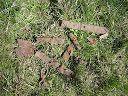
A number of anomalies can be related to known modern interventions: fences and wires (primarily along the southern survey limit), excavation trenches, the modern road, recent ploughing, and landscaping in the manor house garden to the south (Figure 23 and Figure 24, blue features and dark-green lines). While the survey area is reasonably magnetically 'quiet', a number of strong discrete anomalies, characteristic of small ferrous sources, were detected; these are assumed to be mostly of modern origin, and can commonly include objects such as horse-shoes and fragments of agricultural equipment. For example, a particularly strong magnetic anomaly approximately 7.5m in diameter (located at coordinates [-90m, 0m]) was investigated with the help of metal detectorists from Thy-Mors detector club, and found to relate to a deposit of modern iron debris close to the surface (Figure 25). While the majority of such modern features do not necessarily influence archaeological interpretation of the site, they are important insofar as their strength masks any weaker archaeological anomalies in the vicinity.
The largest areas of previous excavation inside the east and west gates correspond to areas of subtly increased magnetic 'noise' visible in the data (Figure 20); a number of more obviously delineated areas of magnetic disturbance are defined in Figures 23 and 24 (dark blue features): a large patch of disturbance, adjacent to the inside of the rampart mid-way between the western and northern gateways (centred at coordinates [-100m, 60m]), corresponds to the position of a windmill marked on a cadastral map from 1812, and probably relates to the construction or demolition of this mill.
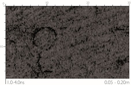
GPR Grid 2, which measured 30 x 18m, was located to investigate a group of strong magnetic responses that appeared to correspond to the location of a test trench from the 1990 excavations, together with a separate subcircular anomaly that could be interpreted as a cut feature of archaeological or geological origin (Figure 22); this is an area that, when compared with the reconstructed fortress plan, may contain part of a courtyard surrounded by a group of buildings.
The shallowest time-slices (Figure 26) show part of a circular system of agricultural maintenance following the line of the reconstructed rampart and present down to a time-depth of c. 7ns, calibrated as a depth of 0.35m. At a very shallow depth, less than 20cm below the surface, an annular anomaly stands out: this appears to be caused by a ring of mushrooms, a fairy ring, which was noted on the surface (due to the season no mushrooms were visible, but the ring was apparent in the colour of the grass). It is likely that the strong contrast visible in the GPR images is caused by the retention of water by the fungus' mycelium. Below the ploughsoil, faint traces can be seen (between x=10-26, y=2-14) of the disturbance of the former excavation trench. The mid- and lower depths of these data also demonstrate well the north-west/south-east striations of the underlying geology of the site, the responses from which correspond with those collected by the magnetometer. This result, though disappointing, is in agreement with the results from the excavation and the reconstructed fortress plan, which did not predict any archaeological features in this area.