As terrain reconstruction reveals (Figure 13), Dussindale was ideally suited to Kett's strategic and tactical requirements, lying within easy reach of the rebels' camp on Mount Surrey and exerting control of the surrounding road networks. The position also benefitted from the surrounding enclosed fields, which, combined with the River Yare to the south, screened the rebels' flanks and compelled Warwick's forces to mount a frontal assault, an endeavour hampered by the Gargytt Hills and Old Ditch stretching across the top of the valley between Great Lumners Close and Readings Close. The obstacle posed by the northern portion of the Old Ditch was enhanced by the hedges of Little Lumners and the adjacent Twenty Acre Close, which dramatically restricted the loyalist cavalry's avenue of approach to the gap between the Twenty Acre Close and Readings Close. The rebels strengthened these natural defences with earthworks and fortifications, Neville stating that they 'entrenched themselves […] and made bulwarks and other defences' while they also 'brought a ditch over the high ways, and cut off all passage, pitching their javelins and stakes in the ground before them' (1575, 62). Southerton similarly attested that the insurgents 'devised trenches and stakes […] and set up great bulwarks of defence before and about' (1549-1559, 259). Although the army's march to Dussindale would have left little time for extensive preparations, the 'bulwarks' described by these narratives could allude to the closes at the north, north-west, and south of the valley, while references to the 'ditch over the high ways' evokes the Old Ditch crossing Peddars/Witton Way and Reading Way. By creating earthworks along the southern portion of the Old Ditch the insurgents would have extended the existing barrier formed by the northern enclosure hedges, further hindering attempts to descend into the valley.
Despite these clear indications of Dussindale's defensibility, written accounts fail to delineate the placement of rebel soldiers within the historic terrain, with the Old Ditch, in the west, and the Doles and Smee, in the east, both providing viable areas for deploying Kett's army. The use of military terrain analysis, however, can resolve this issue through the inference of the rebels' deployment based upon their force's composition and equipment. As the insurgents were armed with longbows and bills they would be more likely to adhere to traditional English tactical deployments from the 14th and 15th centuries, which were designed to maximise the effectiveness of these weapons in the absence of cavalry, pikes, or firearms. When arrayed in this fashion, English armies used linear units of billmen, often no more than four ranks deep, with wings of archers in open-order formations, preferably positioning their troops atop gentle slopes with flank protection and broken ground or obstacles ahead of them to slow approaching troops (Barr 2001). The success of these tactics in conflicts such as the Hundred Years War stemmed from the longbow's ability to harass targets at distances of up to 400m, provoking enemy forces to advance into the weapon's optimum range of 150m, where a trained archer could loose four or five arrows per minute (Strickland and Hardy 2005). The formations of those who survived to reach the English line were inevitably disordered by such concentrated shooting, as well as the obstacles placed in their path, allowing their charge to be received by the billmen, before archers, armed and trained for close-quarter fighting, launched counterattacks against their exposed flanks (Strickland and Hardy 2005).
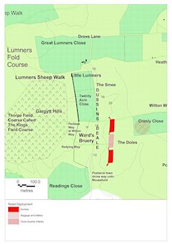
The eastern edge of Dussindale was ideally suited to these tactics, allowing the rebel army to protect its flanks with enclosures and compelling the loyalists to descend into the valley and climb the opposite slope to reach Kett's position, exposing themselves to concentrated archery as they did so. The insurgents also used stakes as defensive obstacles, a common English tactical measure employed since Agincourt (1415), 'pitching their javelins and stakes in the ground before them' (Neville 1575, 62), and combined this stratagem with the unconventional decision to place gentlemen taken prisoner throughout the rising in chains before their front line (Southerton 1549-1559). These measures served a similar purpose, being intended to screen Kett's forces from incoming fire and disrupt the momentum of the loyalist assault so that the rebels could absorb their charge more effectively. Figure 14 provides an interpretation of this deployment, taking Neville's assertion that the rebels 'cut off all passage' (1575, 62) to the highways to denote a position between Peddars/Witton Way and Reading Way. When arrayed in its traditional fashion, with billmen in the centre and archers on the flanks, the army, having a similar number of soldiers to the English army at Crécy (1346), would require approximately 450m to deploy (Strickland and Hardy 2005), and so would fit between Readings Close and the Twenty Acre Close. The rising ground of the Doles would provide a vantage point further east for Kett's ordnance, with larger cannons probably being placed within Cranly Close alongside the army's baggage, where they could be grouped into batteries and protected by the surrounding hedges. Smaller field pieces were commonly assigned to infantry units for localised artillery support (Arnold 2001), a deployment alluded to by Southerton's statement that the rebels 'placed their ordnance all about them' (1549-1559, 259).