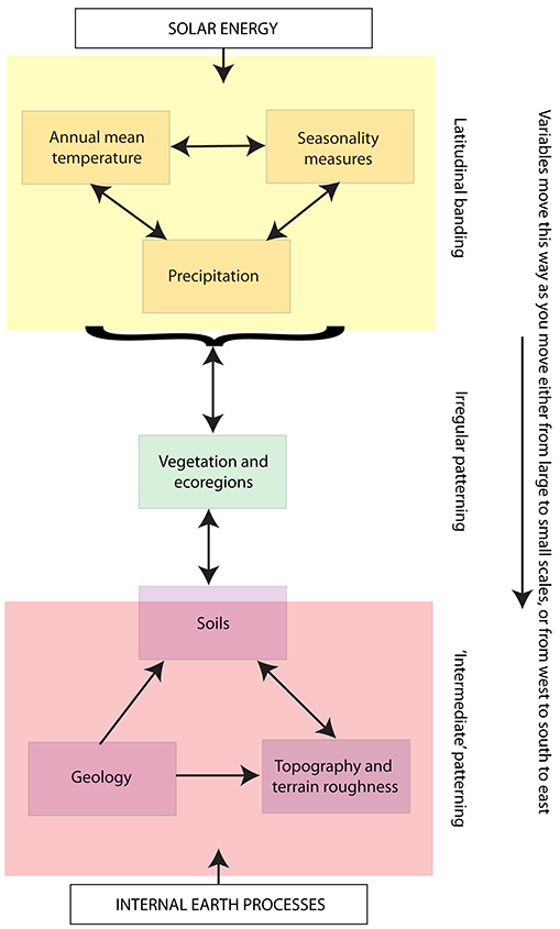
These patterns in the spatial structures of different environmental variables seem to fit well with a relatively simple understanding of the Earth system. In particular, the prevalence of latitudinal banding patterns in the climatic variables (at least at larger scales) can be explained as a reflection of the structure of the global atmospheric circulation, which forms three latitudinal circulatory cells in response to the uneven distribution of incoming insolation (Lutgens and Tarbuck 2001). The patterning in the physical landscape variables, in contrast, is a response to the distribution of geological, tectonic and volcanic activity, a pattern which is not regular, but is linked to the distribution of tectonic plate boundaries and active faults (Partridge 2010). The final group of factors, which include vegetation, ecoregions and (to a lesser extent) soils, are intermediate in their spatial pattern because they result from interactions between variables driven by each of these two major forcing factors (Foley et al. 1998; UNRCS no date; Retallack 2007). The precise balance between solar and geological forcing clearly differs by variable and region, but overall the spatial structures of extant African landscapes seem to fit well with these simple models. This patterning is summarised in Figure 12.
As we move down from the continental to the local scales, the influence of internal Earth processes on spatial patterning in all landscape variables increases (the equivalent of shifting all the variables towards the base of Figure 12), to different degrees in different regions: in the west, all that happens as you go from the continental to the regional scale is that the ecological variables – which here started relatively high up towards the climatic end of the figure – and their climatic equivalents shift a little downwards, while in east Africa, the regional scale rapidly compresses the distribution until 'irregular' and occasional intermediate patterns dominate the whole suite of variables. Central and south Africa are both intermediate. The shift from the regional to the local scales has a similar effect in each case.
Internet Archaeology is an open access journal based in the Department of Archaeology, University of York. Except where otherwise noted, content from this work may be used under the terms of the Creative Commons Attribution 3.0 (CC BY) Unported licence, which permits unrestricted use, distribution, and reproduction in any medium, provided that attribution to the author(s), the title of the work, the Internet Archaeology journal and the relevant URL/DOI are given.
Terms and Conditions | Legal Statements | Privacy Policy | Cookies Policy | Citing Internet Archaeology
Internet Archaeology content is preserved for the long term with the Archaeology Data Service (ROR). Help sustain and support open access publication by donating to our Open Access Archaeology Fund.
File last updated: Wed Mar 4 2015