The split with the last chimp-human common ancestor occurred some 6 million years ago. The next obvious question, given the clear relationship between broad landscape patterning and the current functioning of the Earth system, is: how much might we expect that system, and hence those patterns, to have changed since then?
The essential workings of the Earth system don't seem to have changed at all during the recent geological periods - in fact, the global atmospheric and tectonic systems seem to have been in place by the start of the Phanerozoic, some 542 million years ago, and would certainly have worked essentially as they do today throughout the Cenozoic, which started 66 million years ago. In fact, the Cenozoic (also called the age of mammals) is the period during which the continents moved to their current positions, and while the climate has shifted during the period, there is no evidence that the basic principles of the climatic system have changed.
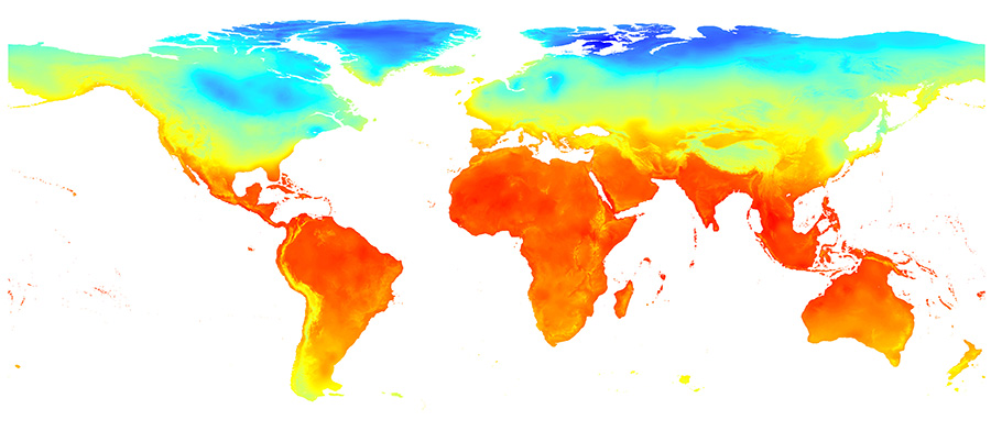
Climatically, during the last 6 million years (Ma), there have clearly been changes in the amount of incoming solar radiation and orbital cycling, which follow known laws and hence are relatively predictable (Barry and Chorley 2003; Behrensmeyer 2006). Other changes, to the thermohaline circulation and other components of the climate system, are less predictable a priori, but have been reconstructed in some detail where they impact on this recent period. This, coupled with the results above, suggests that – at least at larger scales where latitudinal banding patterns dominate climatic maps, and perhaps also in west Africa at the regional scale – we should be able to map, with some accuracy, how the long-term changes to climate recorded in ice cores would have shifted the bands on climatic maps, and hence what overall conditions would have been like for different regions at different times. Palaeoclimate modelling results (e.g. Dowsett et al. 1999; Haywood and Valdes 2006; Haywood et al. 2000) seem to support this suggestion, as they all show latitudinal banding with some modification from the major features of the physical landscape. This can be seen, as just one example, in Figure 13, which shows a global map of climatic conditions at the Last Glacial Maximum, reconstructed by the Community Climate System Model v4. As this figure suggests, patterns at this scale are broadly latitudinally banded but with modifiers associated with the Rift Valley, the Andes and the Tibetan Plateau.
At the smaller scale, climates are much less predictable - as the regional maps presented here show - but this article has shown that they also become more closely linked to the distribution of physical landscape features, and particularly coastlines and terrain anomalies. At the 'local' scale, it seems reasonable to expect that if we could reconstruct broad values from large-scale climate mapping, and the topography of the physical landscape, it should still be possible to draw basic conclusions about the likely general distribution of micro-climates in the past.
What, then, about the prospects of reconstructing past physical landscapes? This article began by noting that there have been suggestions that this is indeed possible (Bailey and King 2011; Bailey et al. 2011; Reynolds et al. 2011; Blumenschine et al. 2012b; 2012c; Stollhofen and Stanistreet 2012). But there have been challenges, and there are still several key unanswered questions. Firstly, we need to know to what extent major tectonic features (which dominate regional or continental maps) shift over millions of years. In the tectonic realm, as in the climatic, most long-term changes are likely to be related to the distribution of activity and stress rather than the way the lithospheric system functions. These changes are famously slow, and have often been considered too slow to influence hominin evolution. At the regional to continental scales, then, while the specific topographies of regions of interest have changed through time as a result of changes to the mantle convection currents (Partridge 2010), their basic type – active or inactive; volcanic, fluvial or tectonic, etc. – is likely to have been much more uniform. Major features, like the African Rift Valley that is so prominent at the regional scale, would have existed and interacted with climate and vegetation in similar ways throughout this period (Tiercelin and Lezzar 2004). This means that for the timescales of human evolution, we can gain a first approximate reconstruction of physical landscapes at the continental and regional scales using maps of current terrain, which may represent a key breakthrough in our ability to reconstruct the overall conditions of human evolution.
A second key question concerns the plausibility of small-scale (local or finer-grained) landscape reconstructions. The analyses presented here suggest that reconstructions of physical landscapes at the small scale would be especially useful for palaeolandscape studies, as these would not only provide us with data about physical landscapes but also seems to provide a route in to reconstructing patterns (if not specific localities) in climate. Landform reconstruction using geological survey, sedimentary analysis and survey techniques has had some success at many key hominin sites, including Laetoli (Dincauze 2000), Olduvai (Blumenschine et al. 2012a), parts of the cradle of humankind (Bailey et al. 2011; Reynolds et al. 2011) and the Middle Awash (Reynolds et al. 2011) among many others. This article has suggested that this effort, particularly when extended beyond the very fine scales of single sites or localities to broader 'local' areas (which most likely are significantly larger than the home range of a single group, but still substantially smaller than the distances across which hominins have dispersed within (Strait and Wood 1999) and beyond (Winder et al. in prep) Africa) is likely to pay dividends when it comes to reconstructing palaeolandscapes. Geographically, physical landscape reconstructions are likely to be most useful to understanding overall landscape patterns in east Africa and – to a slightly lesser degree – in south Africa, while in west Africa the continental scale reconstructions of terrain and geology/soils are likely to tell us only about the patterns in those specific variables.
Vegetation and ecoregion distributions would seem to be the hardest things to reconstruct, based on the analyses presented here, as they are typically 'intermediately' patterned and vary more both geographically and with scale. The goal of reconstructing vegetation types (open, closed, semi-open etc.) is likely to be more realistic at all scales than that of reconstructing ecoregions (as supported by the large-scale success of projects using models to do just that, e.g. Haywood and Valdes 2006; Salzmann et al. 2008). Gaining a better understanding of the limits to species distributions and ecoregions – particularly where these correlate with topographic features – might still improve our abilities to reconstruct palaeoecosystems at smaller scales, however.
Internet Archaeology is an open access journal based in the Department of Archaeology, University of York. Except where otherwise noted, content from this work may be used under the terms of the Creative Commons Attribution 3.0 (CC BY) Unported licence, which permits unrestricted use, distribution, and reproduction in any medium, provided that attribution to the author(s), the title of the work, the Internet Archaeology journal and the relevant URL/DOI are given.
Terms and Conditions | Legal Statements | Privacy Policy | Cookies Policy | Citing Internet Archaeology
Internet Archaeology content is preserved for the long term with the Archaeology Data Service (ROR). Help sustain and support open access publication by donating to our Open Access Archaeology Fund.
File last updated: Wed Mar 4 2015