Cite this as: Geophysical Surveys of Bradford 2015, 1993 Geophysical survey, in M. Atkinson and S.J. Preston Heybridge: A Late Iron Age and Roman Settlement, Excavations at Elms Farm 1993-5, Internet Archaeology 40. http://dx.doi.org/10.11141/ia.40.1.geophys
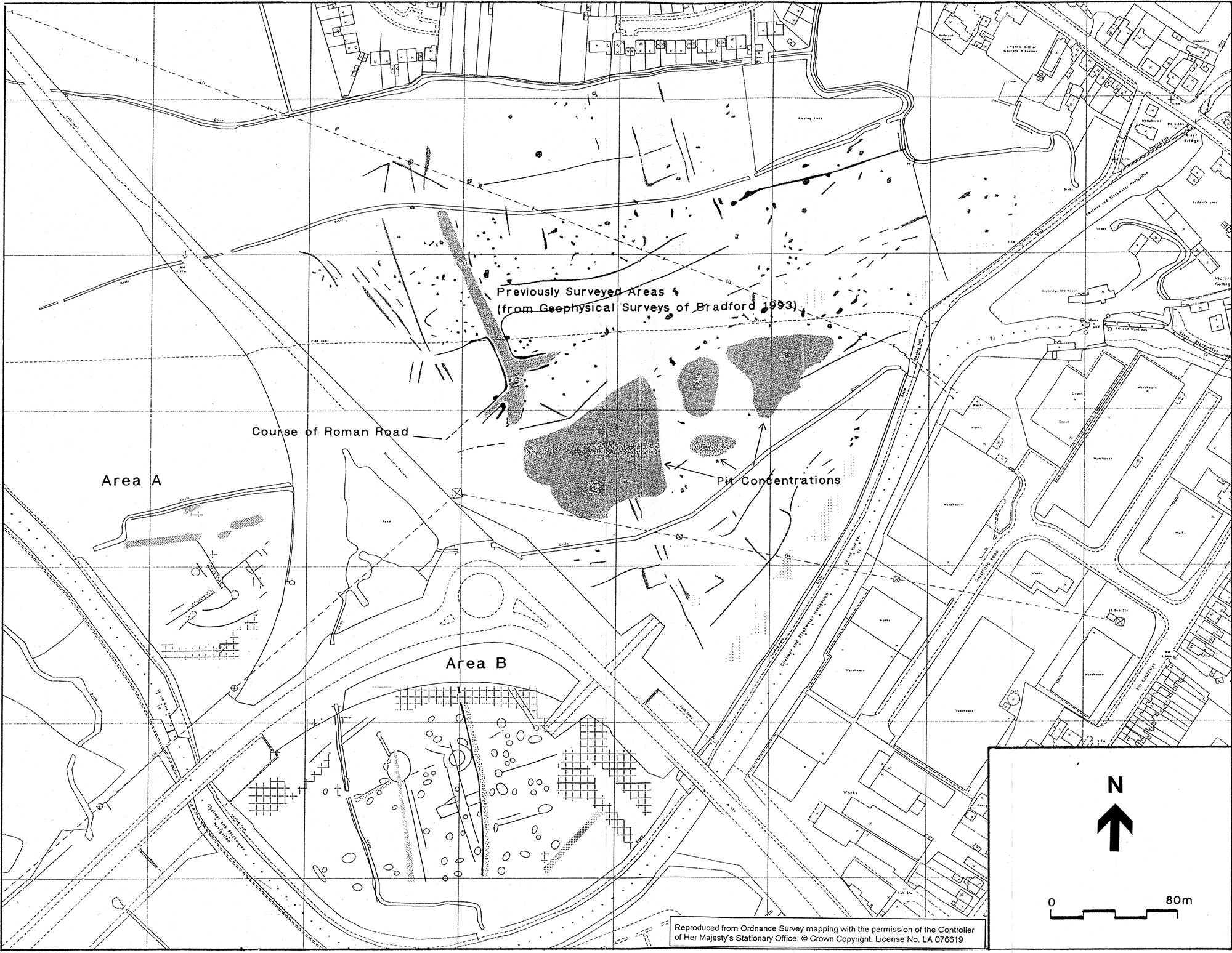
The survey discussed in this report covers approximately 13 ha. within the Elms Farm development area, which totals some 19 ha (see Figure 1). The site lies to the east of a dismantled railway line and to the north of the Chelmer and Blackwater Navigation Canal. Four fields, all of which were level and in use as rough pasture at the time of the survey, were surveyed by gradiometry. The underlying geology consists of alluvium overlying gravels.
An initial survey was undertaken to determine whether the site was responsive to gradiometry (1993). This entailed rapid scanning of the area and a detailed gradiometer survey, measuring 80m by 80m, carried out over the projected line of the Roman road and presumed core/centre of the town. Several anomalies of archaeological interest, including possible ditches associated with the Roman road, were detected. Magnetic susceptibility measurements indicated relatively high enhancement in the area of the postulated road.
The gradiometer survey referred to above had the aim of delimiting the town, locating any additional features such as field systems, and identifying any evidence of earlier or later archaeological activity, prior to the excavation of the site.
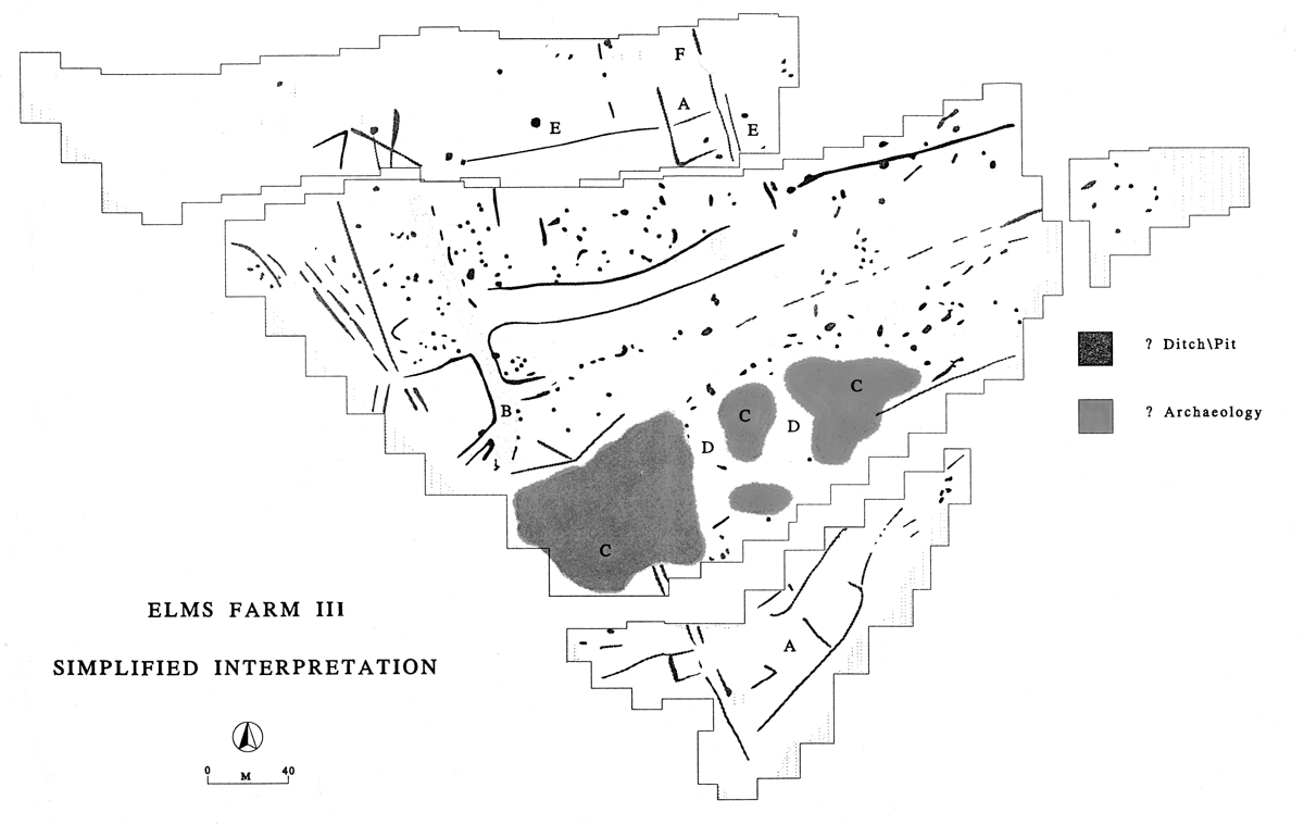
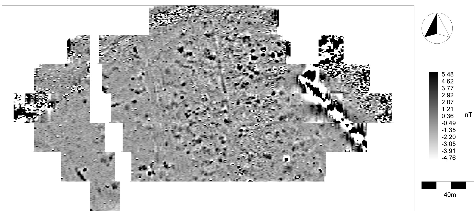
A brief summary of the results with reference to a composite grey scale plot follows; unusually the positive anomalies have been plotted in white (Figure 744). A more detailed discussion of the results and archive plots are provided in the archive report (Colchester Museum).
The gradiometer survey located a wealth of anomalies of archaeological significance, the main elements of which are discussed below. Letters in parentheses below refer to anomalies in the summary interpretation (Figure 745).
There are two trends in the data, SW-NE and NW-SE, with the majority of the anomalies respecting this alignment. There are many linear ditches across the site that follow this general trend. Several of the ditches suggest enclosures, particularly in the north and south of the survey area (A). The alignment of the anomalies is comparable to the cropmarks recorded to the north of the survey area, suggesting a continuation of the same complex.
Part of the postulated Roman road appears to have been located (B), although the 'road' has not been detected throughout the length of the survey area. There is a suggestion of an additional road in the centre of the survey area at a right-angle to the main one.
The results are dominated by a band, approximately 60m wide, of strong pit-like responses (C) running NE-SW across the site. Within this band there are noticeable quiet areas (D), which are aligned NW-SE and are devoid of anomalies. It is possible that these strong responses are associated with buildings and the quiet areas represent streets. While a natural origin, such as magnetic gravels from an old river course, cannot be completely ruled out, the nature of the responses and their orientation and context, suggest that an archaeological origin is most likely.
There are many short ditch- and pit-like anomalies scattered across the site, which may be archaeological. However, some of these may represent pockets of magnetic gravels. In the north of the survey area there are two large pit-like responses (E) that are perhaps geological. However, immediately to the north of these responses several Grubenhauser have been excavated and these anomalies may represent similar features.
A curving area of strong responses (F) in the north of the survey area coincides with a depression in the ground and most likely indicates a former stream channel, which may have been significant.
Areas of ferrous disturbance are visible along the edges of the survey area and are due to fences, pipes and the dismantled railway line. There are also several telegraph poles and water troughs, which have created areas of disturbance.
Cite this as: Wardill, R. 2015, Geophysical survey report on land to the south west of the excavations at Elms Farm, in M. Atkinson and S.J. Preston Heybridge: A Late Iron Age and Roman Settlement, Excavations at Elms Farm 1993-5, Internet Archaeology 40. http://dx.doi.org/10.11141/ia.40.1.wardill
The magnetometer survey was commissioned by the Elms Farm Project as part of ongoing post-excavation research. Its aim was to build upon previous investigations carried out by Geophysical Surveys of Bradford (1993) by surveying a further two fields, totalling approximately 4.2 hectares, to the south-west of the 1994/5 excavation site (Area A TL84740/07900 (centred) Area B TL84900/07760 (centred); Figure 1). These fields represent the last remaining areas of undisturbed land within the immediate vicinity of the excavated area, and it was hoped that the survey would produce information on the nature of settlement activity further towards the River Chelmer.
Both fields were flat, level and under pasture making them generally well suited to the requirements of a magnetometer survey. The majority of perimeter fencing was constructed of steel wire and wooden stakes to a height of around 1m, which tended to cause intrusive magnetic interference from a distance of about 1-2m. Waterlogging was a minor problem in the south-west corner of the southerly of the two fields with up to 200mm of standing water present. The underlying geological material consisted of river terrace gravels which are overlaid by alluvium towards the River Chelmer.
Two phases of excavation, undertaken by the Essex County Council Field Archaeology Group in 1993 and 1994/5, revealed extensive and complex remains of an important multi-phase site.
Evidence was found for prehistoric landscape use, the presence of an important Late Iron Age local centre and a large Roman settlement with clear signs of continuity of occupation between its precursor and a later Saxon settlement. The main span of occupation included evidence of high-status activity in the Late Iron Age, a temple complex which developed throughout the life of the settlement, and a clearly defined infrastructure of roads, surfaced open areas and plots across which zonation of activity, particularly of manufacturing, can be discerned (Atkinson and Preston 1996).
The general aim of the survey was to determine the extent and character of buried archaeological remains within the survey areas.
Specific objectives include confirming any spread of occupation activity associated with the excavated settlement, and locating the continuation of a known Roman road the path of which is projected into the northerly field.
Magnetometry detects anomalies in the earth's magnetic field caused by the redistribution and alteration of iron oxide particles. Such disturbances may be due to local geological variations but human activities also significantly influence the geomagnetic field.
The technique is particularly good at detecting structures and features incorporating fired clay such as kilns and hearths. Features with a high brick or tile content generally produce strong mixed polarity responses due to the varying orientation of each magnetically enhanced artefact. The detection of pits and ditches depends upon the existence of magnetic contrast between the backfill of a feature and the geology into which it has been cut. Again, these features produce positive magnetic responses although usually weaker than those caused by fired materials. Walls and foundations constructed of masonry are detected in a similar way although the signal is negative owing to the generally low magnetic properties of these materials.
The two fields comprising the survey were designated as Areas A and B (Figure 746). Within both areas a survey grid of 20m x 20m squares was established in alignment with the Ordnance Survey national grid. Magnetic data was collected within these squares at a sample interval of 0.5m and a traverse separation of 1m. The survey was carried out using a Geoscan Research FM36 Fluxgate Gradiometer and ST1 Sample Trigger.
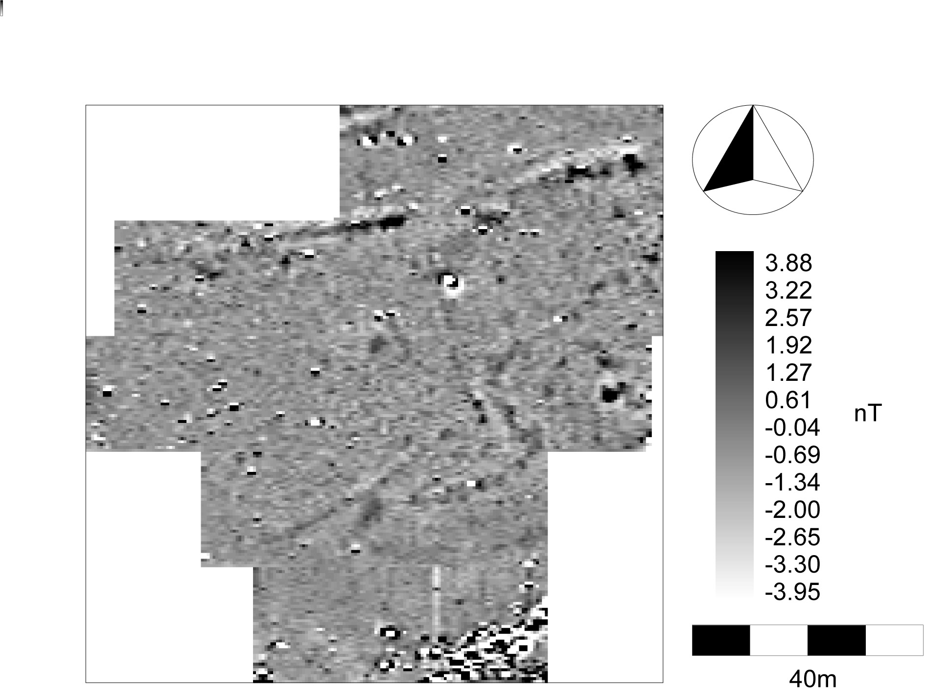
A number of well-defined magnetically positive anomalies indicative of archaeological ditch and pit features were located within this area (Figure 746, Figure 747 and Figure 748).
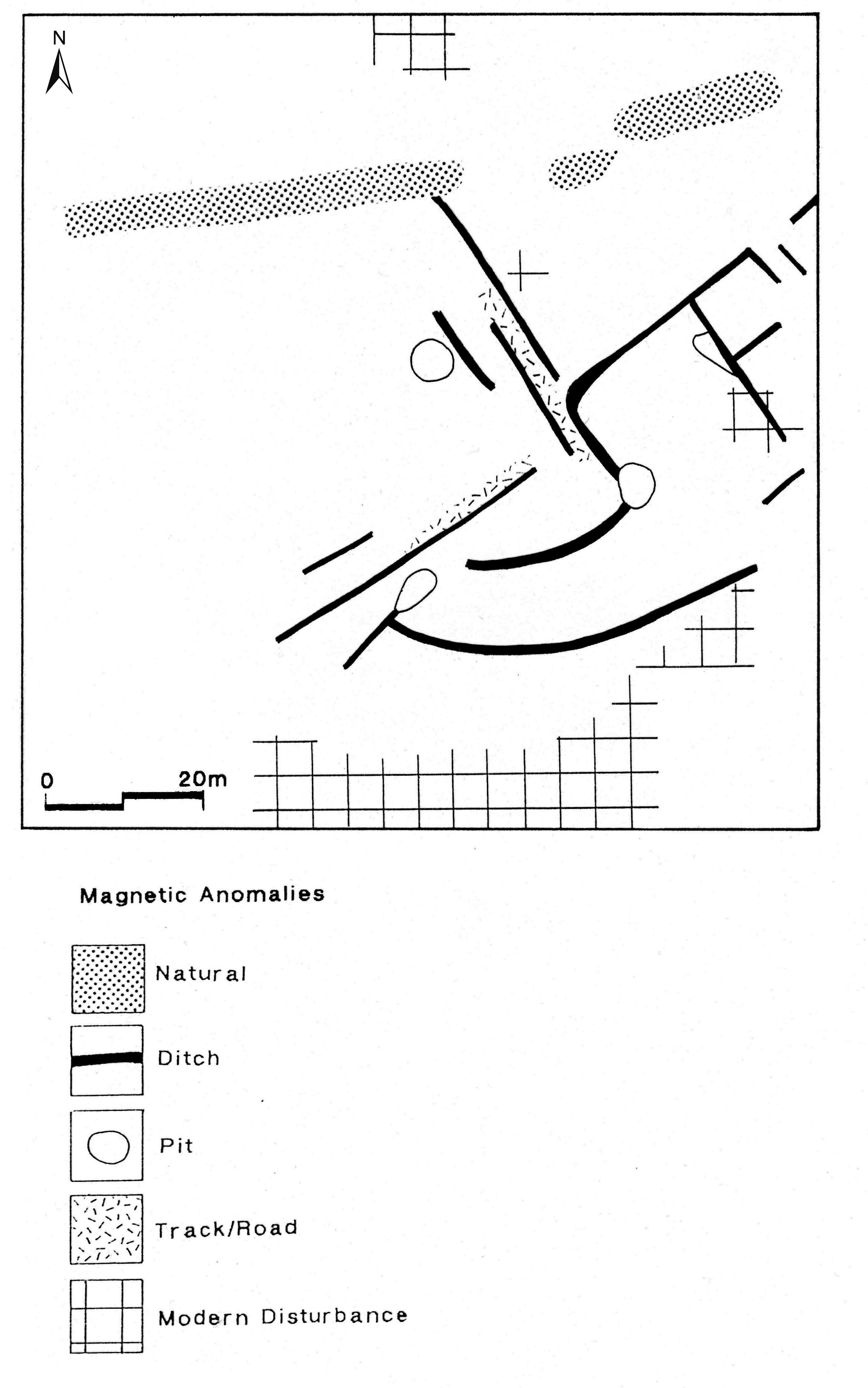
The majority of the ditch anomalies lie on one of two principal orientations, NW-SE and SW-NE. This reflects the general trend of alignment identified within the excavated areas and suggests that the features detected within Area A form part of the same Late Iron Age/Roman settlement. There is some magnetic evidence for possible improved surfaces, indicating the presence of track or roadways. It is probable that some of the longer lengths of ditch within this area also delineate such features, the surfaces of which have deteriorated or are not detectable. None of the detected anomalies can be associated with structures.
Anomalies characteristic of archaeological features were also detected in Area B. However, identification and interpretation of these features is problematic due to the density of pit features and possible near-surface disturbance (see Figure 746 and Figure 749).
A number of ditch anomalies can be discerned, some of which, particularly those evident as parallel pairs, may represent trackways although there was only limited evidence for an associated hardened surface (6). The orientation of the majority of these ditches conform to the alignments identified in Area A. A similar conclusion can therefore be drawn that these features form a continuation of the excavated settlement areas to the north. The exception to this alignment is the linear anomaly (1). Here a well-defined strip of positive data, indicative of a ditch approximately 1.5-2m wide, borders a possible trackway or bank remnant that abuts its eastern edge. This feature appears to overlay or cut anomalies interpreted as forming part of the settlement, which would suggest a later date for its origin.
The concentration of pits identified within the area resembles spreads of similar features located during the geophysical survey of 1993 (GSB 1993) (Figure 746). During excavation these were found to contain domestic material primarily of Late Iron Age/Roman date. It is possible that the pits located within Area B represent similar settlement activity. The pit concentration, together with the detection of anomalies in general, tends to diminish towards the west of Area B. This may indicate a limit of settlement; however, it is probable that this low-lying land has suffered from frequent inundation with the resulting sedimentary deposits masking underlying archaeological features.
Several of the ditch anomalies within Area B are characteristic of more complex archaeological features. Anomaly (2) delineates an ovoid enclosure approximately 20m across at its widest point. It comprises a ditch approximately 0.5-1m wide, and a possible entrance way to its north-west.
Anomalies (3) and (4) consist of two roughly rectangular enclosures around 8m wide. These may represent evidence of building activity
Anomaly (5) may also indicate the presence of structural remains in the form of two narrow (approximately 0.5m) concentric circular ditches, the diameter of the outer being around 18-20m. This anomaly is similar in plan to the temple found during the earlier excavations to the north; however, the outer ditch of that structure was approximately 32m in diameter.
The survey was successful in locating a number of magnetic anomalies characteristic of archaeological features and deposits that enabled the specific objectives set out above to be achieved.
Although the feature density and disturbance within Area B caused some identification difficulties, overall the magnetic anomalies detected in both areas were found to be of sufficient definition to be interpreted with reasonable confidence.
From the survey results it is clear that the settlement discovered to the north-east extends fully into the two survey areas and probably beyond. There is also strong evidence for the continuation of the Roman road, also located during previous investigations, through and beyond Area A.
Internet Archaeology is an open access journal based in the Department of Archaeology, University of York. Except where otherwise noted, content from this work may be used under the terms of the Creative Commons Attribution 3.0 (CC BY) Unported licence, which permits unrestricted use, distribution, and reproduction in any medium, provided that attribution to the author(s), the title of the work, the Internet Archaeology journal and the relevant URL/DOI are given.
Terms and Conditions | Legal Statements | Privacy Policy | Cookies Policy | Citing Internet Archaeology
Internet Archaeology content is preserved for the long term with the Archaeology Data Service (ROR). Help sustain and support open access publication by donating to our Open Access Archaeology Fund.