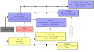
It would appear that single context recording and stratigraphical excavation experience a far better correlation between the methodological ideals and the technology and features available through GIS and CAD solutions (Figure 3). However, we arguably have a general problem of inherently incoherent and fragmented recording systems, with parallel series of data that of course tend to be correlated but not fully integrated. This is in part strongly related to a lack of software that covers all the needs of archaeological digital documentation, but perhaps even more so it relates to a digital methodology that is influenced by handling spatial data in a file system.

This is addressed by Wright (2011), who demonstrates how web technologies can help to integrate spatial data. Based upon the Web 2.0 philosophy and willingness to share data, and built on the semantics of the domain ontology for the cultural heritage sector (CIDOC-CRM) to allow for data query using the Semantic Web Query Language (SPARQL), the project outlines the possibilities of integrating spatial data by translating vector data to comply with the Resource Description Framework (RDF) or RDF-triplets. The strength and versatility of the semantic web is currently being further explored through the GeoSemantic Technologies for Archaeological Resources (GSTAR) doctoral project by Cripps (2013), which is investigating how geospatial data can be integrated within semantic environments. This is an extension of The Semantic Technologies for Archaeological Resources (STAR) project between English Heritage and the University of South Wales (May et al. 2011; 2012; Cripps and May 2010) and the Semantic Technologies Enhancing Links and Linked data for Archaeological Resources (STELLAR) project, which includes the Archaeology Data Service (May et al. 2012).
The existence of these projects clearly demonstrates, that outside of specific research projects, trends in field recording shows data generally managed as parallel series of data, with spatial data managed by GIS, more or less detached from other non-spatial, textual data. This means that spatial data is rarely fully integrated into what we consider the archaeological documentation. Not only do we see parallel series of data, the issues are potentially increasing as new technologies and new data types are introduced. The advent of 3D documentation especially, necessitates preparations for a much broader display of data types and spatial representations.
Internet Archaeology is an open access journal based in the Department of Archaeology, University of York. Except where otherwise noted, content from this work may be used under the terms of the Creative Commons Attribution 3.0 (CC BY) Unported licence, which permits unrestricted use, distribution, and reproduction in any medium, provided that attribution to the author(s), the title of the work, the Internet Archaeology journal and the relevant URL/DOI are given.
Terms and Conditions | Legal Statements | Privacy Policy | Cookies Policy | Citing Internet Archaeology
Internet Archaeology content is preserved for the long term with the Archaeology Data Service. Help sustain and support open access publication by donating to our Open Access Archaeology Fund.