The groundworks monitored during the watching brief revealed a spread of archaeological features and deposits over most of the monitored area. When these features were plotted against a ground plan of the features revealed during the earlier excavation, it could be shown that several of the walls and one of the culverts were continuations of previously excavated features.
In the discussion that follows, the features are discussed under category and with reference to Figure 3, which shows the recorded features in relation to the wider site and the excavated areas.
Browse via image gallery (Figures 38-40)
1 / 3
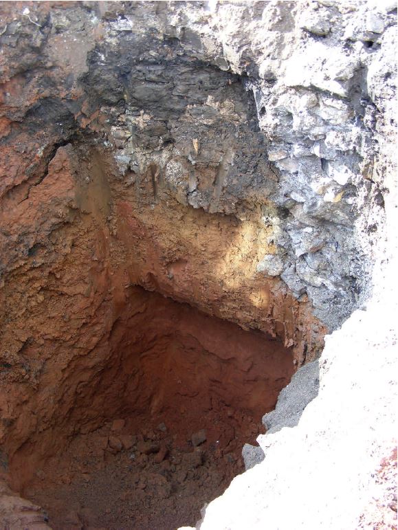
Figure 38: North-east facing section after removal of Well 118, showing Wall 119 (to right of frame), Wall 120 (in centre, top), the natural substrate (Redcliffe Sandstone, Context 124) in base, overlain by alluvial silt (Context 123) and various redeposited layers
2 / 3
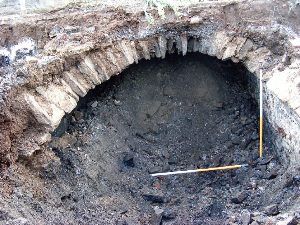
Figure 39: South-east facing view of sandstone cellar vaulting (103) fronting Little Anne Street, with Wall 106 to right of frame. Scales: 2×1m
3 / 3
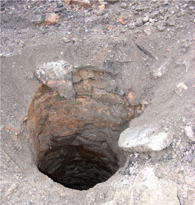
Figure 40: Well 171, showing Pennant Sandstone lining
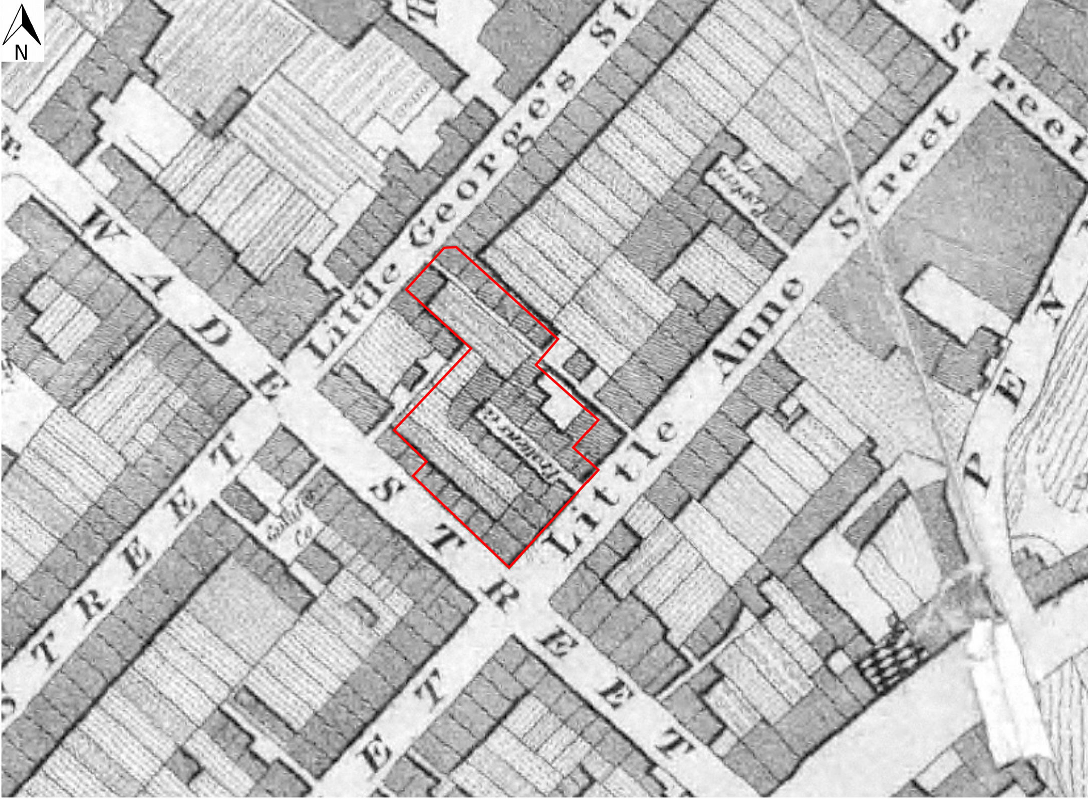
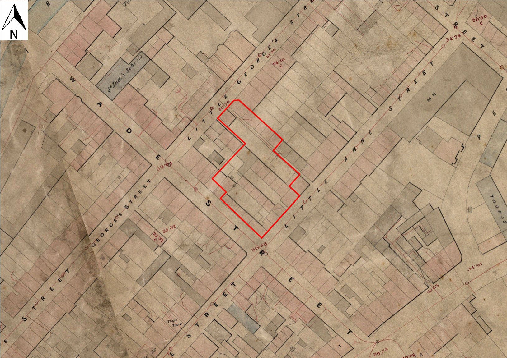
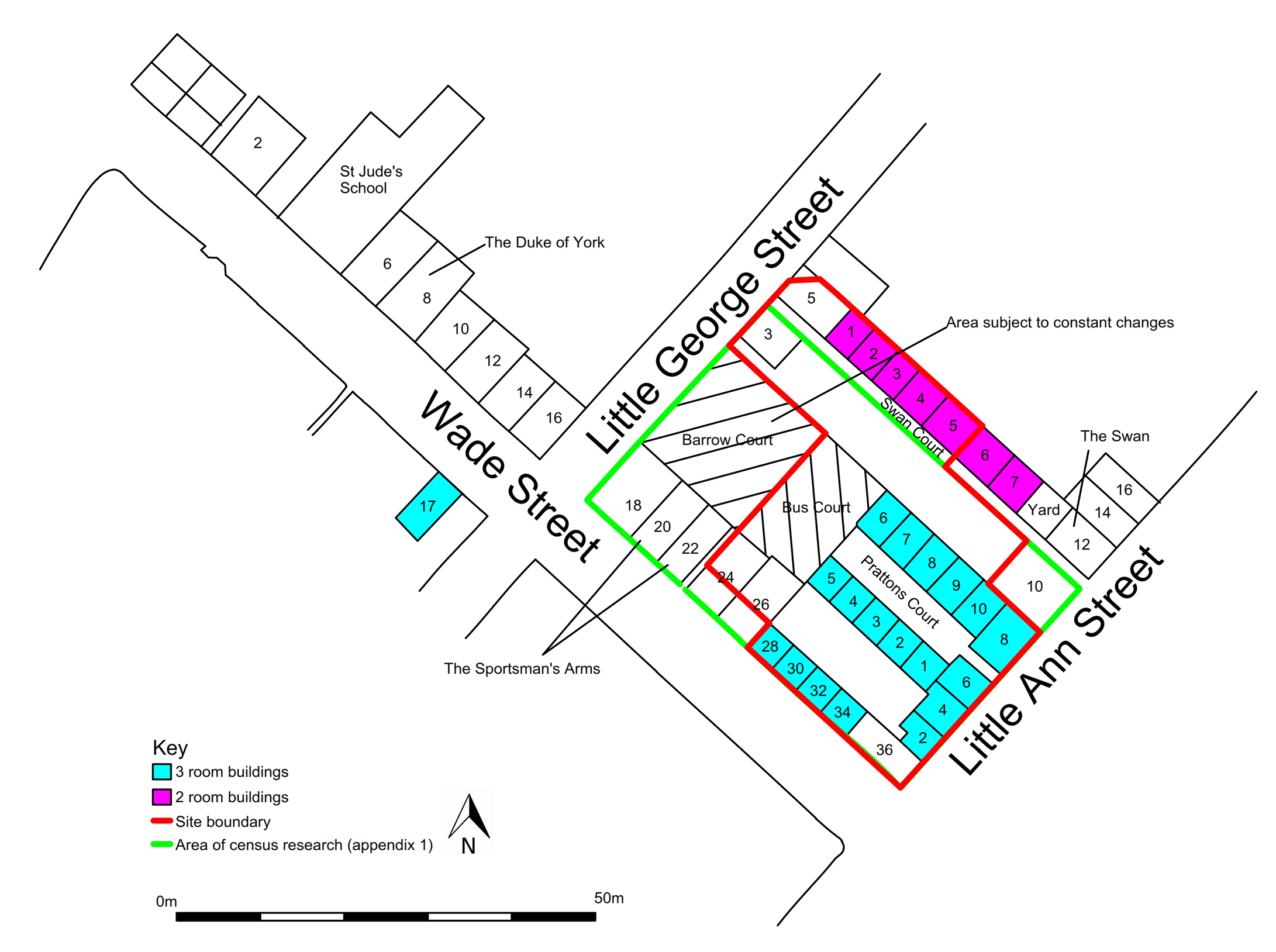
Structures identified during the watching brief included at least two cellars, three wells, two culverts, a possible cistern later used as a midden and numerous wall foundations, some of which could be related to buildings shown on the plan of the study area of 1881-2 (Figure 8). Significant among the latter is Wall 146, which was probably a continuation of Wall 1010 in Excavation Area A, and would have formed the foundation to the front party wall of the south-west arm of Pratten's Court (Figure 4). Wall 139 probably formed a continuation of Wall 1043 in Excavation Area B, and would have formed the foundation to the rear wall of the north-eastern arm of the buildings of Pratten's Court.
The majority of the wall foundations recorded during the watching brief was of similar construction, namely Pennant Sandstone masonry, often incorporating some bricks, and bonded with a grey lime mortar. Six of the wall foundations (Contexts 109, 110, 112, 120, 143 and 150) were bonded with buff or pinkish mortar. The majority of the foundations were trench-built into the underlying alluvium/river gravel, much of which is likely to have been redeposited (Contexts 108/136/152/162) at depths varying between 1.2m and 1.7m below the modern ground surface. Wall foundation 159 was unusual in being sited apparently directly upon deposit 123/136, at a depth of only 800mm below the present ground surface, and was also unusually wide. Two walls only, both short stubs of masonry (Contexts 168 and 114) appeared to have been constructed entirely of brick.
Enclosed dump deposits or middens
Walls 120 and 137, together with Wall 119, appeared to have formed a 'utility area', enclosing Well 118 to the south-west and cess/ash midden (121 and 122) to the north-east (Figure 3). It is possible that Walls 137, 119 and the north-western end of Wall 120 together originally formed a lined cistern, such as was recorded in the valuation of 1882 of a property further north-west along Wade Street and it was used as a midden only after its original function had ceased.
Similarly, Walls 179 and 180 are likely to have originally formed part of a cellar, which was later used as a midden and enclosed a large deposit of clay tobacco pipe (Context 174; Figure 3). This was an important discovery, as it may cast direct light on the nature of very small-scale industrial activities both on the site and in its immediate environs, and it seems worth noting here in rather more detail. Deposit 174 also yielded stoneware of probable 19th-century date, and was contained within a dark sooty matrix. The majority of the pipe fragments were of 19th century date, and comprised complete bowls, most of which had not been smoked, in a variety of typical 19th-century designs, including basket-weave, acorn and stylised ribbed seams. One bowl, with a spur heel, is marked with the initials, 'JW' either side of the spur, and is likely to be the product of either James or Joseph White II, or John Wilkey I (below) who were working at 26 Wade Street in the 19th century (Beckey and Price 2006, 115-20). One of the accompanying stems has a green-glazed mouth-piece, another 19th-century innovation, possibly introduced to guard against lip cancer, and which has also been identified on pipes of the White family (Beckey and Price 2006).
It is also possibly significant that both dump deposits were located within 7.5m of each other (Figure 3), in an area that is likely to have lain at the north-western end of Pratten's Court (Figure 4, Figure 5, Figure 6, Figure 7, Figure 8 and Figure 21).
Wells
The three wells recorded during the watching brief were of similar Pennant Sandstone construction, and varied in depth between 4.4m and approximately 5.4m. Water was recorded in the base of Well 171, at a depth of 4.4m below the modern ground surface. The upper masonry of Well 175 incorporated a modern brick repair to a depth of 1m below the modern ground surface.
None of the three wells revealed during the watching brief were recorded on any of the historic maps available for the area. Nineteenth-century map evidence (Figure 4, Figure 5, Figure 6, Figure 7, Figure 8 and Figure 21) suggests that Wells 171 and 175 are likely to have been sited in the back-yards of contemporary buildings for much of that period, and that Well 118 may have been situated within a building, at least from 1828 onwards (Figure 4). This latter well was completely dug out during the watching brief, enabling examination of the surrounding deposits here. On top of the basal Redcliffe Sandstone, which was recorded at some 3m below the present ground surface, was a deposit (123) of what was almost certainly in situ alluvial silt, reinforcing the point that the site must historically have lain well within the flooding regime of the River Frome.
Culverts
Two culverts were recorded during the watching brief, both of brick and Pennant Sandstone construction, and sited at between 800mm and 1m below the present ground surface. The culverts measured 300mm and 480mm high, respectively, and Culvert 140 appeared to have been constructed in a cut within the alluvial layer (Context 136). Both culverts were aligned south-west/north-east, and were filled largely with black silty material. With respect to the Plan of 1881-2, only Culvert 140 appeared to correspond to any pre-existing features, the possible covered alleyway recorded immediately to the north-west of 2 and 9 Pratten's Court (Figures 8 and 21).
Cellars
Two areas of cellar vaulting were recorded, both on the periphery of the study area, one, of Pennant slabs, adjacent to Little Anne Street (Context 103, Walls 105, 106 and 181), and one, of brick, adjacent to the north-east boundary of the site (Contexts 129, 130, 131 and 132). The vaults were of similar widths (1.8m and 1.85m) and were revealed at depths of between 400mm and 550mm below the modern ground surface.
Comparison of the plan of features recorded during the watching brief (Figure 3) with the 1881-2 Plan (Figure 8) would suggest that Cellar 103 corresponds approximately to the floor plan of one of the houses fronting Little Anne Street, and that Cellar 129 would have extended beneath Swan Court, and that its north-eastern wall would have been formed by the foundation to the south-western boundary wall of the buildings bounding the south-west side of the above court. It is possible that the area of collapsed brickwork (Context 165), observed in section just south-east of Little George Street, may also have represented the remains of a third cellar.
Floor surfaces
Floor surfaces were recorded in three locations, the largest of which was located close to the north-west boundary of the site, and consisted of a Pennant slab floor (Context 172), over 7m long (south-west/north-east). As noted above, this flagstone floor may have formed a part of Buss Court, one of the four 'courts' leading off Little Anne Street and Wade Street, which constitute a characteristic feature of the study area (see below). A second small area of Pennant floor (160) was recorded just north-west of Excavation Area C, and formed a probable continuation to the large area of flooring recorded as Context 1184 during the preceding excavation.
The smaller area of floor (Context 160) probably fell within the area of Swan Court, at its north-western end. The larger area (Context 172) is likely to have fallen within an area of open yard beyond the north-western end of the former Pratten's Court, latterly known as Buss Court (Figures 8 and 21). It is possible that this latter area of slabs may have extended to the south-west as far as the site entrance, where slabs were observed fronting Wade Street.
A further small area of flooring (Context 115), of diamond cross-cut brick pavers, was recorded immediately to the north-east of brick stub Wall 114. This is likely to have formed part of the yard area between the buildings fronting Wade Street and those fronting Pratten's Court. This surface was presumably analogous to (1072), found at the north-western end of Area B in the main excavation, and may represent the same (probable late 19th/early 20th century) phase.
Deposits
The most significant of the archaeological deposits recorded during the watching brief was the discrete area of dark silty material containing clay tobacco pipe fragments recorded in the angle of Walls 179 and 180, the potential significance of which we have already noted. Although no kiln material was observed in association with this deposit, it is thought that it probably represents wasters from the White/Wilkey families' factory at 26 Wade Street, of which the above walls probably formed a part (Price 2014, 4410-4571).
Full excavation of Well 118 (above) revealed a complete stratigraphic sequence, to a depth of some 4.4m below the modern ground surface (Figure 38), consisting of Redcliffe Sandstone, overlain by alluvial silt, in turn sealed by a redeposited alluvial silt, variously recorded during the watching brief as Contexts 108, 136, 152 and 162, and containing sparse finds of 18th-century date; these included clay tobacco pipe and ceramics. Most of the structures recorded during the watching brief (and during the excavation) appeared to have been trench-built into this redeposited silt, which was variously recorded during the excavation as Contexts 1115, 1106 and 1131.
Buss Court
It is possible that the two wells (171 and 175), together with slab floor (172) may have formed part of Buss Court, one of the four 'courts' or side alleys surrounded by dwellings within the study area. The small alley leading to the court is first shown on Ashmead's plan of 1855, running up the north-west side of 26 Wade Street (Figure 6), but it is likely that no actual houses were built as part of the court until some time between 1881 and 1891, as it was not listed on census records until the latter date. It is possible that the earliest housing to the rear of no. 26 was the cottage first mentioned in the census record for 1871 (see Appendix 1), which then later became incorporated into what became known as Buss Court. Such courts are a noted feature, not just of the study area, but of housing development within central Bristol, from the late 17th century onwards, and constituted a form of urban infill, sometimes part of the original development of a particular street, which provided lower cost small-scale inner-city housing behind the main street frontages (Leech 2014, 187 ff.).
Finds
Finds retrieved during the watching brief include a significantly large discrete deposit of unsmoked 19th-century clay tobacco pipe fragments, most likely waste material from pipe manufacture. This material may, in fact, serve to tie in the archaeological evidence with the documentary record (see Appendix 3), as it suggests that the room in which the deposit was found, to the rear of 26 Wade Street, formed a part of the pipe factory owned by the White and Wilkey families between c. 1840 and c. 1871, and run as a sizeable pipe manufacturing business. It should be noted, however, that no associated kiln fragments or other evidence of in situ manufacturing of any sort were recovered during the watching brief. The majority of the other finds recovered (mostly unstratified ceramics, glass and clay tobacco pipe) was of 18th-century date, with some 19th and 20th-century material.
No evidence for activity earlier than the 18th century was revealed during the watching brief.
Internet Archaeology is an open access journal based in the Department of Archaeology, University of York. Except where otherwise noted, content from this work may be used under the terms of the Creative Commons Attribution 3.0 (CC BY) Unported licence, which permits unrestricted use, distribution, and reproduction in any medium, provided that attribution to the author(s), the title of the work, the Internet Archaeology journal and the relevant URL/DOI are given.
Internet Archaeology content is preserved for the long term with the Archaeology Data Service (ROR). Help sustain and support open access publication by donating to our Open Access Archaeology Fund.