Cite this as: Heaton, R. The Census Records and the Wade Street Community in the 19th Century in N. Corcos et al. Excavations in 2014 at Wade Street, Bristol - a documentary and archaeological analysis, Internet Archaeology 45. https://doi.org/10.11141/ia.45.3.1
Wade Street lies at the heart of the area of Bristol known as St Jude's. It is usually only commented upon in passing within historical publications and is often described as having been one of Bristol's slums:
This district with its thickly clustering old houses, and rookeries, its dank courts and blind alleys, its 'dark entries’ and back-yard shed dwellings, common lodging houses and tramps' retreats, its thieves' haunts and prize fighters' quarters, long had a reputation as the abode of the utmost squalor and misery, abject poverty, personal improvidence, and social wrong (Townsend 2007).
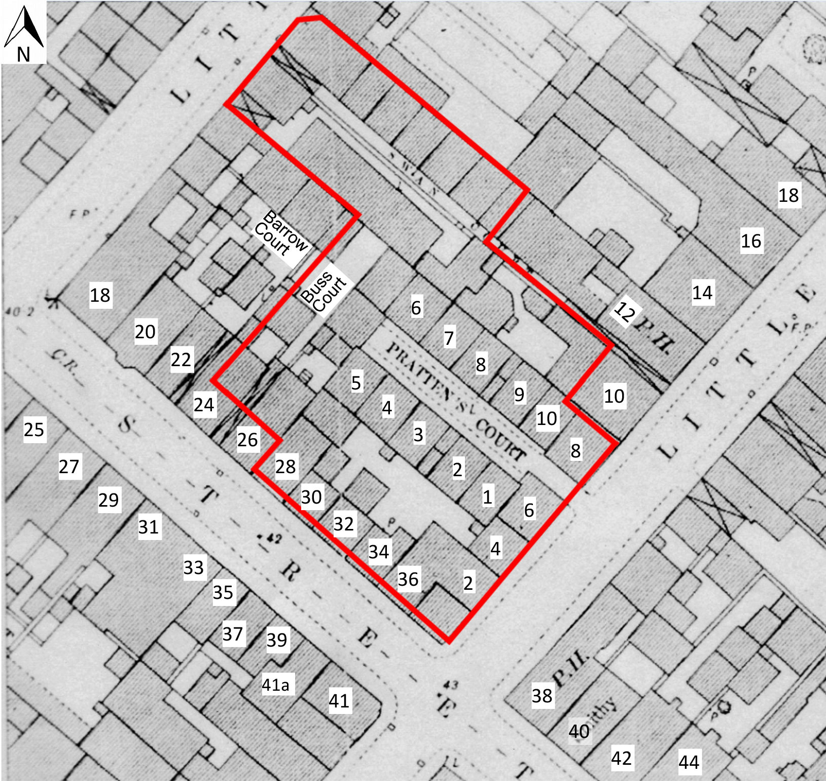
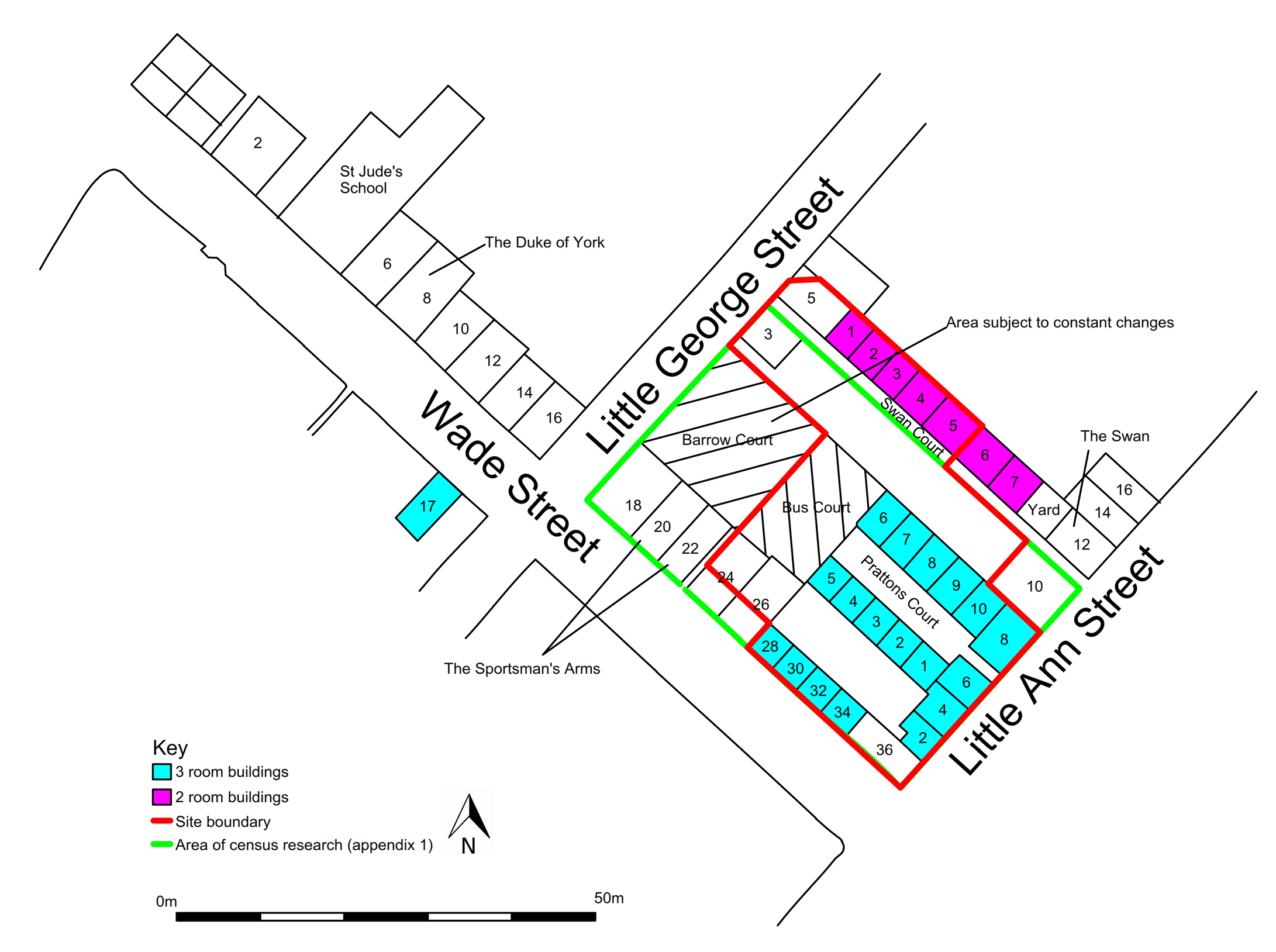
The district was occupied formerly by a poor working-class community, and the quotation above does appear to provide a fairly accurate description through the later part of the 19th century. The study centres on an area of approximately 2000m², which was taken to comprise the following: 18 to 36 Wade Street, 2 to 12 Little Anne Street, 1, 3 and 5, Little George Street, all of Pratten's Court, 1 to 10 and 1 to 7 Swan Court, and two previously unknown courts: Barrow Court and Buss Court, which appear from 1871 and 1891 respectively. This area includes the immediate vicinity of the excavation and the watching brief carried out by Avon Archaeology Limited, as well as the previous evaluation, undertaken by Bristol and Region Archaeological Services.
By using information taken directly from the National Census, it was possible to find out a great deal about the development of Wade Street community. The census provided a fascinating insight into the people who lived within the buildings the remains of which we excavated. It contained not only information about the population and employment patterns, but aided our understanding of how the site had evolved. The following text can provide only an impression of the immediate area of the site rather than a detailed assessment, which would, we feel, justify a separate project in its own right. All the census data used was derived from the online resource http://ancestry.co.uk.
The first National Census of England and Wales was taken in 1801, and the procedure has been repeated at ten-yearly intervals since then, with the exception of 1941, during the Second World War. The early census returns were essentially a head count, recording total numbers of individuals (males and females counted separately) in each parish. From 1841 onwards, each individual was named and some personal details were recorded, occasionally including occupation and some indication of location of birth. The extent of the census changed through time, with additional information being collected. In 1851, additions included the position of each person within a family i.e. Head, Wife, Daughter etc., employment details, as well as the location of birth, and whether any individuals were regarded as having a disability (see Table 1). By 1891, information on how many rooms were occupied in each property was also recorded, 'to include the kitchen but not the scullery, landing, lobby, closet, bathroom, warehouse, office or shop’. An enumerator collected the data, moving from house to house, in order, and following a specific route. From 1911, each household completed their own census return.
| Address | 1851 | 1861 | 1871 | 1881 | 1891 | 1901 | 1911 |
|---|---|---|---|---|---|---|---|
| Wade St | 10 | 12 | 11 | 10 | 9 | 9 | 8 |
| Little George St | 3 | 3 | 3 | 5 | 6 | 4 | 4 |
| Little Anne St | 6 | 4 | 6 | 6 | 6 | 6 | 6 |
| Pratten's Court | 10 | 10 | 10 | 10 | 10 | 10 | 10 |
| Swan Court | 7 | 7 | 7 | 6 | 7 | 7 | 6 |
| Barrow Court | - | - | 2 | 4 | 4 | 3 | 3 |
| Buss Court | - | - | - | - | 2 | 2 | 2 |
| Overall property count | 36 | 36 | 39 | 41 | 44 | 41 | 39 |
| Uninhabited properties | 4 | 3 | 0 | 3 | 0 | 4 | 1 |
The research centred on a rectangular block of land at the south-west end of a larger block, bounded to the south-west by Wade Street, to the south-east by Little Anne Street, to the north-west by Little George Street, and to the north-east by Eugene Street (see Figure 21). This block extends beyond the strict excavation area and was chosen to provide a sample of the demographic of St Jude's. Data were collected from each available census from 1841 to 1911, discounting the earlier 1801 to 1831 records as they only provide a head count for the entire parish (St Philip and St Jacob).
It was possible to identify the relevant records easily from the 1871 census onwards; the routes that were taken by each enumerator to collect data were clear, and each record included a property number that remained in place into the 20th century (see Figure 21), making the records easily comparable. The records from 1841, 1851 and 1861 were not so easily identifiable as no house numbers were recorded, though each house may well have had a number when the records were made. It was, however, possible to identify the separate properties of 1851 and 1861, and to assign the later house numbers to them by using key properties, such as the Ship Inn and the Swan With Two Necks, as markers, as well as identifying families who remained in the same property for the duration of more than one census trawl. It was not possible to identify properties accurately from the 1841 census, as records available for this area were not consistent, and were therefore also discounted.
By 1851, the property boundaries and street plans were firmly established, but there was opportunity to provide extra housing where space permitted as the population increased, and the need for housing grew over the succeeding years. The census revealed that additional properties were built upon land between and to the rear of those fronting the established streets and courts, with the number increasing to a peak of 44 separate properties, or 'dwelling places’, by 1891 (see Table 1), by which time two additional courts, known as Barrow Court and Buss Court, were recorded.
Ten properties fronted the Wade Street side of the study area (18 to 36), but an additional two properties appear on the 1851 Census within the relevant section of Wade Street; both properties are recorded as 'cottages behind’. Listed after no. 24 and before no. 26, we can infer that they were located on the land to the rear of these properties; maps show a passage between no. 24 and no. 26 that would allow access. This is supported by the record of 1871 which describes a 'cottage to the rear of No. 26’. Other records indicate that light industry, primarily clay-pipe making, was also being conducted in the structures to the rear of no. 26 for some time (see Appendix 3).
There is no record of either cottage in 1881; if a property were uninhabited it would usually be marked as such. This could suggest that the former 'cottages behind’ had been demolished or, more likely, the enumerator may not have regarded the buildings as houses, but as sheds or outhouses; in 1881, it is more than likely that these buildings were in use for purposes other than habitation, most probably for some kind of light industry. It is probable that the buildings, in whatever form, were used to accommodate people again by 1891, when 'two cottages’ were inhabited by three families (two families were sharing one 'cottage’); and by which time the area was considered formally as Buss Court.
The same situation occurs with the establishment of Barrow Court, which is named formally in the census from 1871 onwards. Initially, two dwelling places are recorded, increasing to a maximum of four in 1881 and 1891. The location of Barrow Court is not precisely known, but can be inferred from the route taken by the recording enumerator. In this case, Barrow Court is recorded between 22 and 24 Wade Street. It is therefore likely that Barrow Court was located to the rear of these properties.
Further evidence of extra housing appears on the short section of Little George Street that is included in the study area, where up to three extra properties are recorded by 1891 located somewhere between house numbers 1 and 5 (recorded as 1a, 2 and 3a). Again, perhaps, it is possible that outbuildings were being used as housing, or properties were being sub-divided.
Map evidence shows that the rectangular parcel of land to the rear of 18 to 26 Wade Street was continually subjected to changes of use, with perhaps temporary structures being altered and modified to provide work space and, more significantly, additional dwelling places as and when required. It is, however, impossible to identify accurately which structure represented which property.
Where the Wade Street frontage had ten numbered properties, Little Anne Street had six (which fall within the study area), numbered 2 to 12. In 1851, no. 2 is recorded as 'being built’, no. 4 is uninhabited and no. 6 was occupied. Ten years later, no. 2 is occupied but there are no records for nos 4 and 6, which suggests that the buildings standing in 1851 had been demolished. By 1871, all six properties were accounted for and remained so into the 20th century. Number 12, 'The Swan With Two Necks’, is the only building within the study area to survive to this day.
From 1891 onwards, the census recorded the 'number of rooms occupied if less than five’ in each property; this included the kitchen. All properties within Swan Court are recorded as having two rooms, with the exception of one property recorded as having four rooms on the 1911 census, but as there is one fewer property at this time we can infer that two have been knocked together. The majority of the properties within the study area had three rooms, including all the properties of Pratten's Court, 2-8 Little Anne Street, and 28 to 34 Wade Street. In the case of properties in Swan Court and in Pratten's Court, the layout is likely to have been similar to that of a surviving original building in Wade Street, at no. 17, on the opposite side of the road, in which each room sits directly above the other (Leech 2014, 181-83). With no apparent basements, this would suggest that the homes of Pratten's Court had a ground floor and two upper floors connected by a stairwell. To what height these buildings stood is impossible to know, but it seems likely that little daylight would have reached the pavement within the court, making it quite a dark place to live. The buildings of Swan Court, on the other hand, although having only two rooms (one atop the other) may have been slightly better lit, as for the majority of their existence the front of the buildings (the south-west side) looked over an open yard (Figures 8 and 21).
There is evidence through excavation that at least some of the three-roomed properties of Wade Street and Little Anne Street (notably 6 Little Anne Street) had basements. The kitchens in these properties may well have been in the basements, a room that would have been recorded as an occupied or living room. If the kitchens were in the basement, these properties may well have had a ground floor and only one upper floor.
The properties within the two courts, Buss and Barrow, seem to have been continually altered and may have started life as temporary structures that became inhabited depending upon need. As noted above, occupied rooms were recorded only from 1891, so it is impossible to tell exactly what the situation was prior to this date. But after 1891, numbers of rooms recorded varied between one and four, which perhaps supports the idea that the buildings were temporary structures being continually added to or divided up depending upon need. The dwellings within these two courts must have been the most unpleasant places to live within the whole study area, crammed as they were into yard space, accessed only by passageways, and not even necessarily built for the purpose of habitation in the first place.
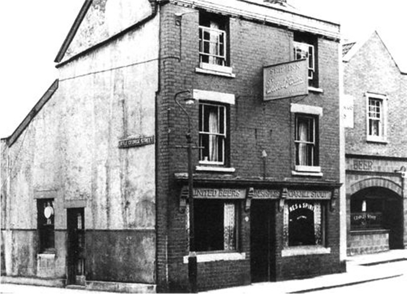
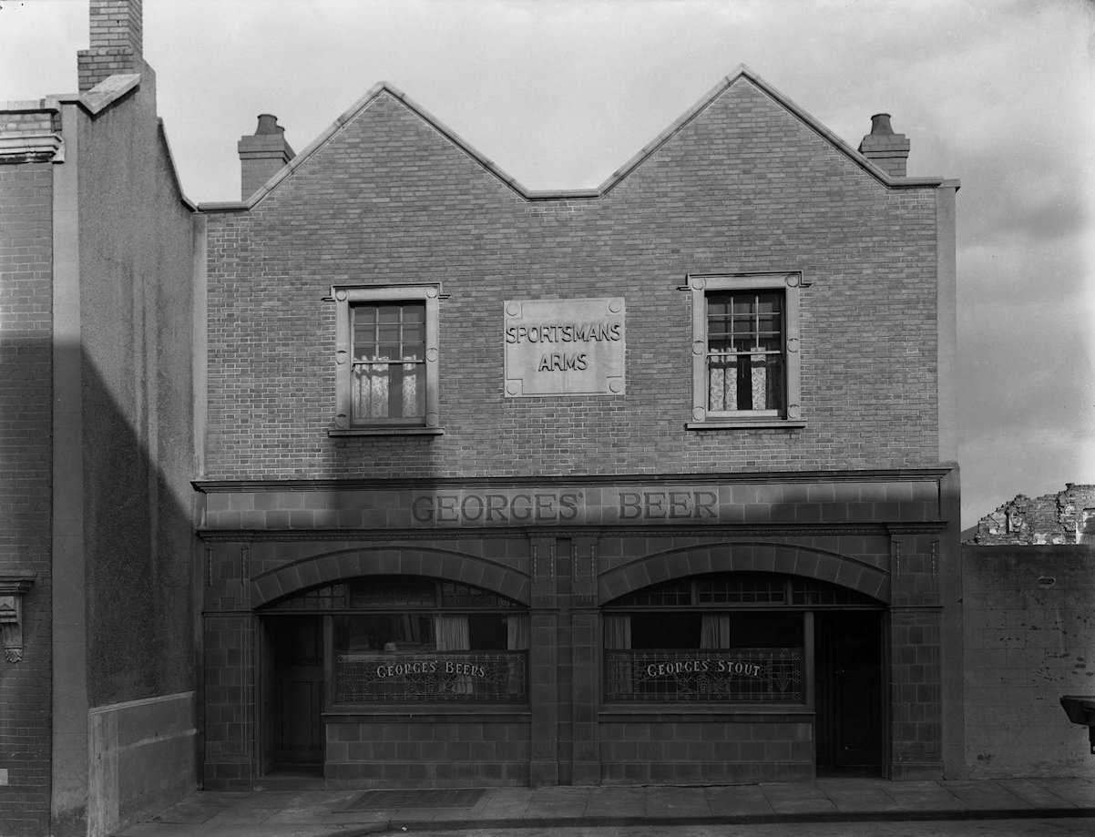
In Little George St, no. 3 is recorded as having four rooms, while all the remaining houses had more than five occupied rooms; map evidence clearly shows the buildings to have been larger, with generally uniform widths but varying lengths. There is photographic evidence of the public houses that provide an indication of the style of adjacent buildings that now no longer exist. The Ship Inn (Figure 43) was located on the corner of Wade Street and Little George Street, and stood three storeys in height, as does the existing Swan With Two Necks, of a similar style. The Sportsman's Arms (Figure 44), next door to The Ship, was of two storeys above ground; it was rebuilt in 1877 and combined nos 20 and 22 (no. 22 does not appear in the 1881 census), to form a double-width property. The frontage has been retained in the Al Baseera Bristol Centre that exists today.
Nationally the population of Britain was growing steadily throughout the 19th century. From the middle of the century adult mortality rates began to fall dramatically, owing to a combination of factors including improved nutrition, rising standards of living, and improved sanitation, though infant mortality remained high until the beginning of the 20th century (Jefferies 2005, 2-5). Between 1848 and the great codifying Public Health Act of 1875, scarcely a year passed without parliament passing legislation to encourage environmental improvement and better public health (McGrath 1985, 131-32). Though there was variation in levels of implementation across the country, Bristol's local board was not inactive in implementing and enforcing legislation, and by 1871 a fairly elaborate code of by-laws, which were in effect the precursors to modern planning regulations, had been adopted to cover the construction of new streets, their sewerage and sanitary provision, as well as space between houses and ventilation of buildings (McGrath 1985).
| 1851 | 1861 | 1871 | 1881 | 1891 | 1901 | 1911 | |
|---|---|---|---|---|---|---|---|
| Total males | 89 | 85 | 134 | 99 | 108 | 95 | 96 |
| Total females | 120 | 97 | 125 | 119 | 111 | 109 | 91 |
| Total population | 209 | 182 | 259 | 218 | 220 | 204 | 187 |
| Children under 14 (males and females) | 78 | 82 | 101 | 90 | 86 | 77 | 75 |
Table 2 shows the number of people living in the study area at each ten-year interval. In 1851, 209 people were occupying the study area, which is close to the average of 211 for any one time. The lowest number of occupants is recorded only ten years later, in 1861, while in 1871 numbers peaked sharply to the maximum of 259, before declining more steadily in the succeeding years.
The apparent dip in population could be the result of localised epidemics resulting in high mortality; cholera was a constant issue in the overcrowded and central areas of Bristol, where drinking water was often polluted (Bettey 1989) and recorded country-wide outbreaks of diphtheria were high in 1857 and 1878, followed by an epidemic of scarlatina (Scarlet Fever) in 1859. The subsequent population rise in 1871 could at least partially reflect various attempts by the government and by the local Public Health Board to improve living conditions and life expectancy, though this is speculative.
Working class districts such as St Jude's often experienced continual movement of people, with families not settling in one place for too long. This would have affected the numbers of people in an area regardless of general trends. Comparison of the occupants of each property for each census year generally recorded a change in the occupants with each successive decade, and a major factor in the movement of people would have been the availability of paid work, and the ability, or inability, to pay rent.
| 1851 | 1861 | 1871 | 1881 | 1891 | 1901 | 1911 | ||
|---|---|---|---|---|---|---|---|---|
| Males in paid employment | 51 | 45 | 82 | 54 | 67 | 67 | 52 | |
| Females in paid employment | 34 | 22 | 50 | 33 | 31 | 29 | 34 | |
| Females recorded simply as 'Housewife’ | 39 | 22 | 15 | 27 | 27 | 31 | 21 | |
| Unemployed | Males | 5 | 6 | 2 | 9 | 1 | 3 | 1 |
| Females | 8 | 4 | 2 | 1 | 3 | 6 | 1 | |
| Unemployed disabled | Males | 0 | 0 | 0 | 1 | 0 | 0 | 0 |
| Females | 0 | 0 | 0 | 0 | 0 | 0 | 0 | |
| Unemployed elderly/pauper | Males | 0 | 0 | 2 | 0 | 0 | 0 | 0 |
| Females | 3 | 2 | 7 | 4 | 4 | 1 | 4 | |
Table 3 shows the numbers of people in employment. In 1871 there were only four people of working age recorded as unemployed, and the lowest number of women recorded simply as housewives. In addition, the number of men in paid employment was just short of double what it had been in 1861, and more than double the number of women were in paid work. This suggests that there was plenty of employment available, a factor that is likely to have encouraged people to move into the district.
As mentioned above, evidence shows that the population within the study area was fairly fluid. However, on looking at the wider picture, we have found that people did not necessarily move very far away, often remaining in the same district, in adjacent streets, or even adjacent houses.
Nonetheless, not all families moved around, and there were a few that did remain in the same place for much longer. The Sparks family are clearly one example who settled permanently, remaining at 28 Wade Street for over 60 years. Over that 60 years the house was occupied by a varying number of kin as the family grew, moved away, or passed away. The Sheppard family, living at 4 Pratten's Court with relatives at no. 7, and the Richards family at the Ship Inn, are other examples of permanency. Common family names crop up in the surrounding area; for example the Pound family were related by marriage to both the Sparks and the Wilkeys. Another prominent family was that named Buss, whose name may well provide the origin of Buss Court, although we have been unable to prove this. At different times this family appears in the records for Great George Street, Wade Street and Little Anne Street.
Generally, at the time of each census, just under two-thirds of the properties housed single families, the remaining properties housed more than one family. Numbers 26 and 36 Wade Street were both larger properties and generally had more than one family living in them at any one time: no. 26 had a maximum of 16 people (in four families) in 1851, and an average of 10 people for the following years with the exception of 1861, when it was occupied by a single family of five, and in 1911 when the building no longer existed; no. 36 also housed 16 people (in five families) in 1851, though the inhabitants varied between three and 13 people over the succeeding years. Both of the above properties had more than five rooms; however, it was found that the smaller properties with two or three rooms (which included the kitchen), occupied by single families, housed generally more people and were therefore more cramped. No. 28 Wade Street is a typical example of a three-roomed house. As mentioned above, it was home to the Sparks/Pound family (1861–1911). Mr and Mrs Sparks had 10 children by 1871, and the house was also occupied by Widow Pound (mother-in-law), making a total of 13 people in all. The population in the area was at its highest in 1871 (see Table 2), and not a single property available within the study area was uninhabited. Pratten's Court was home to its peak population of 71 people at this time, the average population here at any one time being 51. On its own, no. 1 housed a family of 13 members, also over three rooms, with the adjacent properties each housing an average of 6-7 people.
Overcrowding was at its worse in 1871 as the population was at its highest, and living conditions must have been quite poor. The majority of people in this area will have been sharing wells for drinking water as well as outdoor privies, with heavy usage of the latter inevitably leading to poor sanitation.
During the 19th century, working age was classified as being between the ages of 14 and 64. Generally, it appears that there was very little unemployment among the residents of the study area, the majority of those who were out of work tending to fall in the younger section of this age group, mostly between the ages of 14 and 25. As mentioned above, availability of employment appears to have been high around 1870.
As one might expect in a district such as St Jude's, the majority of the population were employed in low-skilled or semi-skilled occupations. A great variety of different occupations were recorded on the census, too many to discuss here in any detail, but the men were engaged chiefly in occupations that involved heavy manual labour, much of it doubtless outside, while the women were more involved in cleaning, washing or small manufacturing-type employment; these occupations also requiring not inconsiderable levels of strength and stamina. Tables 4 and 5 show the most common occupations of the men (Table 4) and women (Table 5) living in the study area; the tables show only those occupations that were recorded five or more times over the period of study. Clearly, the most common type of employment for men was labouring and for women (other than housewife), it was laundry-related work.
Some of those working as labourers identified the industry in which they were employed; it is not surprising for a city such as Bristol, based around a thriving port, that there were a high number working on the docks. In addition to those industries recorded in Table 4, labouring jobs were also recorded at the sugar works, the print works, the glue works, the chocolate factory, the iron works and the tannery. Many of these 'Works’ were located close to St Jude's; for example, an oil and colour works was located at the north end of Little George Street, as was a tannery.
A fair few of the women were recorded as working from home, presumably to enable care of young families at the same time as trying to earn a wage of some sort. Common home work recorded included 'laundry work’, 'dress making’, 'knitting’ and 'skewer making’. Tobacco was an important industry in Bristol throughout the 19th and well into the 20th century, and it employed both men and women, as shown in Tables 4 and 5. It was also an industry that changed significantly between 1851 and 1911. Those employed in tobacco in 1851 were generally involved with making clay pipes and preparing the tobacco for use in pipes. This peaked in 1871, after which there was a decline in pipe making. Towards the end of the 19th century, those involved in the industry were predominantly women making cigarettes and cigars, reflecting changing fashions in society as a whole regarding the ways in which tobacco was actually consumed, and the concomitant shift in the tobacco industry away from the once ubiquitous clay pipes.
There were only a handful of people recorded in what one might call 'professional’ occupations: in 1851, an officer of the Inland Revenue was staying at the Ship Inn, and a nurse is recorded at 36 Wade Street; in 1871 a teacher is recorded at 34 Wade Street, and in 1891 a commission clerk lived in Swan Court, all but the clerk being recorded as 'visitors’. Three apprenticeships for skilled trades were also recorded: in 1851 an apprentice cooper; in 1891 an apprentice scale-maker; and in 1911 an apprentice to the India-rubber works.
| 1851 | 1861 | 1871 | 1881 | 1891 | 1901 | 1911 | |
|---|---|---|---|---|---|---|---|
| Clay pipe maker | 1 | 2 | 3 | - | - | - | - |
| Boot/shoe maker/cordwainer | 4 | 1 | 2 | 1 | 6 | 3 | 4 |
| Errand boy | 2 | - | 2 | 1 | - | - | 1 |
| Firewood/stick hawker | - | - | 4 | 2 | - | - | - |
| Fishmonger/fish salesman | - | - | - | - | 2 | 2 | 3 |
| Milliner/hatter | 2 | 3 | 1 | 1 | - | - | - |
| Haulier | 1 | 1 | 1 | - | 5 | 1 | 1 |
| Hawker (street tradesman) | 1 | 1 | 1 | - | 3 | 2 | 1 |
| Horse hair worker/curler | - | - | 5 | - | - | - | - |
| Labourer | 14 | 12 | 21 | 17 | 14 | 6 | 4 |
| Labourer, specified at brickyard | 1 | - | 4 | 1 | - | 2 | - |
| Labourer, specified at the docks | - | - | 3 | - | 6 | 12 | 9 |
| Labourer, specified at Gas Works | - | - | - | 2 | 1 | 2 | - |
| Labourer, specified as mason's labourer | - | - | 1 | 7 | 2 | 8 | - |
| Labourer, specified at Oil Works | 1 | - | 4 | - | - | - | - |
| Mason | 1 | 1 | 2 | 2 | 1 | - | - |
| Victualler/publican/inn keeper/beer seller | - | 2 | 3 | 2 | 1 | 3 | 3 |
| 1851 | 1861 | 1871 | 1881 | 1891 | 1901 | 1911 | |
|---|---|---|---|---|---|---|---|
| Boot/shoe maker | - | 2 | - | 3 | 1 | 2 | 2 |
| Box maker (cardboard) | - | - | - | 1 | 2 | - | 4 |
| Charwoman | 3 | 2 | 1 | 4 | 3 | 3 | 1 |
| Clay pipe maker | 3 | 2 | 3 | 3 | - | 1 | - |
| Cotton spinner | - | - | 2 | 3 | 4 | 1 | - |
| Dress maker | 1 | - | 1 | 4 | 1 | - | - |
| Flax spinner | - | - | 5 | 2 | 1 | - | 1 |
| Housewife | 29 | 22 | 15 | 27 | 27 | 31 | 21 |
| Milliner/hat trimmer | 2 | - | 1 | 3 | 1 | - | - |
| Laundress (inc. ironer and mangler) | 9 | 7 | 5 | 1 | 4 | 3 | 2 |
| Servant | 3 | - | 1 | 1 | - | - | 2 |
| Tailoress | - | 2 | 1 | - | 3 | - | 3 |
| Tobacco worker (inc. spinner/packer/paper mouth piece maker/cigar maker) | - | - | - | - | 1 | 5 | 4 |
| Victualler/publican/inn keeper/beer seller | 2 | - | 2 | - | 1 | - | - |
| Wood/stick cutter | - | 3 | 15 | - | 3 | - | - |
At any one time, approximately one-third of the population of the study area was made up of children; those between the ages of 0-14. It is clear that the numbers of children having some level of education increased markedly after 1861. This date is significant as St Jude's School, located at the north-west end of Wade Street, was built and opened towards the end of 1860. A letter written by a Mr Wellstead to one of the school governors (name illegible in the manuscript), in January 1863, refers to the school accounts and records his surprise at the uptake:
'It affords me great pleasure to state that expectations I had formed when the new buildings were erected have been fully realised’. He goes on to say that 'We have a certified Master and Mistress and the attendance of children has steadily increased’, and that 'considering the character of the district and the class of persons with whom we have to deal these results will be pleasing’ (BRO P.st Ju/sch/1)
Of course, the census does not tell us if those children recorded as 'scholars’ attended on a full- or part-time basis, but clearly, parents were glad of the opportunity afforded their children to be educated on anything even approaching a formal level. The 1901 census for this area does not record whether children were scholars, but we can assume that approximately two-thirds of those between the age of 5 and 14 probably were; this omission is likely to be down to the enumerator recording in that year. The following census, in 1911, also 'bucks the trend’, with a significantly lower number of children attending school. In that year, the head of each household completed their own census form, and therefore what was recorded was presumably far less systematic, and more variable, than for those years in which the recording had been undertaken by official enumerators.
| 1851 | 1861 | 1871 | 1881 | 1891 | 1901 | 1911 | |
|---|---|---|---|---|---|---|---|
| Child 5-14 (not in education) | 43 | 42 | 35 | 18 | 20 | 68 | 48 |
| Scholar 5-14 (in education) | 28 | 31 | 55 | 60 | 57 | - | 17 |
| Infant 0-5 | 7 | 9 | 11 | 12 | 9 | 9 | 10 |
| Total | 78 | 82 | 101 | 90 | 86 | 77 | 75 |
The data provided by the census records did not contradict previous accounts of the St Jude's district occupied by lower social classes, where housing was crammed into every available space, large families occupied small homes, and where employment was generally unskilled, manual labour. On the surface, the community appeared to be a fluid one, with people moving in and out of the area frequently, although closer examination showed that often people were part of large, extended families that were predominant in the district. The census also detailed the physical evolution of the site from 1851 onwards, identifying the construction, demolition and replacement of buildings, including the construction of two new courts that are nowhere explicitly identified by name on maps of the area.
While the information here provides a limited view into the development and community of the study area, we consider that the census provides very significant potential for further research into social composition, education, housing standards, family size, economic activities and occupations, both in the immediate vicinity of the excavation site, and in the far wider district of St Jude's as a whole.
Internet Archaeology is an open access journal based in the Department of Archaeology, University of York. Except where otherwise noted, content from this work may be used under the terms of the Creative Commons Attribution 3.0 (CC BY) Unported licence, which permits unrestricted use, distribution, and reproduction in any medium, provided that attribution to the author(s), the title of the work, the Internet Archaeology journal and the relevant URL/DOI are given.
Terms and Conditions | Legal Statements | Privacy Policy | Cookies Policy | Citing Internet Archaeology
Internet Archaeology content is preserved for the long term with the Archaeology Data Service (ROR). Help sustain and support open access publication by donating to our Open Access Archaeology Fund.