 (September 2017)
Institute of Archaeology, UCL, 31-34 Gordon Square, London WC1H 0PY, UK. Email: [email protected]
Cite this as: Harris, B. 2017 Review of Pocket Guide Megaliths [app], Internet Archaeology 45. https://doi.org/10.11141/ia.45.7
App for iPhone and iPad developed by Senet Mobile UK. £1.99 (free to members of the Megalithic Portal Society). Available: https://itunes.apple.com/gb/app/pocket-guide-megaliths/id1069332919?mt=8
The Pocket Guide Megaliths app was developed by Senet Mobile UK in collaboration with The Megalithic Portal website. The app was released in 2016 and is currently available for iOS devices, such as iPhone and iPads. Pocket Guide Megaliths presents the Megalithic Portal's burgeoning worldwide database of ancient and prehistoric sites in a variety of innovative and engaging ways. It aims to act primarily as a guide to enjoying and exploring the rich prehistoric heritage of the world, though offers additional functionality for would-be monument explorers too.
The roots of The Megalithic Portal go back to 1997. Around this time, Andy Burnham (a self-declared amateur archaeologist and web developer) compiled something called the Prehistoric Web Index, a directory of hyperlinks to further information on prehistoric sites throughout northwestern Europe. Out of this, he and a colleague then developed the Megalith Map, an MS Access-powered, interactive and wonderfully GIF-based map showing the locations of the indexed sites along with any additional information relating to them. Following a transition to open-source technologies, the Megalith Map became the core of The Megalithic Portal (MP) website, which was launched in 2001 (Figure 1). In line with other web-based 'inclusionist' projects at the time (e.g. Wikipedia), the MP opened up the existing Megalith Map database to a new community of enthusiastic explorers and potential contributors. A forum-like site structure enabled new users to add both new sites to the database and additional photos, observations and information relating to pre-existing entries.

Fast-forward to 2017 and the MP community is nearly 6,500 contributors strong and officially registered as a not-for-profit membership society with its own committee. The database of prehistoric sites — spanning China to Chile — now numbers over 50,000 and Andy and a team of site administrators maintain and develop both the database and website on a voluntary basis. Data has been collated from a variety of sources and includes personal thoughts, musings and observations. There is, of course, a discussion — beyond the purview of this review — about the various challenges posed and benefits offered by 'crowdsourced' archaeological datasets such as the MP (see Lake 2012). As discussed below, through its reliance on the MP database, Pocket Guide Megaliths offers one particularised and valuable perspective on the prehistoric heritage of the UK and beyond.
Much like the MP website, Pocket Guide Megaliths is minimalist in style; navigational links are presented in regularly-sized lists next to columns of somewhat pixelated, playful icons. Some text pages (e.g. the app help and site visiting guidelines pages) are without any styling and a simple blue-grey gradient background is present throughout the app. Overall, Pocket Guide Megaliths has a functional, retro look and feel which runs counter to more recent trends within mobile app design, which tend to favour bold vector graphics and patterned or photographic backdrops (e.g. CADW's app reviewed by Rothenberg 2017). The app is simply structured and is divided across four main tabs displayed at the bottom of the screen; 'Pocket Guide', 'Map', 'Info' and 'More'. The first two of these tabs offer different ways to filter and navigate the vast MP database, which users must download when using the app for the first time. The latter two tabs contain additional tools and external information relating to the sites featured in the app.
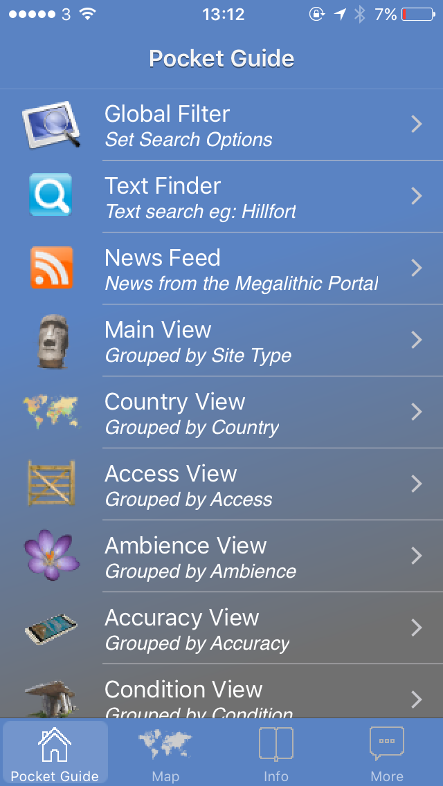
The 'Pocket Guide' tab (Figure 2) — really the main page of the app — contains a series of different text-based methods of searching , filtering and displaying sites contained within the MP database. The 'Global filter' option allows users to specify the type of site that they are interested in (e.g. ancient mine, cairn, wedge tomb etc.). There is also an option to filter by country which is essential considering the global extent of the MP database. The real benefit of the Global filter, however, is provided by the 'Megalith properties' option. This feature allows users to restrict which sites they see based on their MP user-assigned scores across multiple criteria (Figure 3). A high rating out of five for 'access' indicates that a site can probably be driven to directly and accessed with a wheelchair. Slightly lower scores indicate short walks, whilst the lowest figures represent sites that are 'in the middle of nowhere' or, quite simply, 'a nightmare to find'. A score of zero indicates that there is no data available within this category. Similarly, a site's score within the 'Accuracy' category will show whether the recorded location is accurate to the metre or in fact refers to the nearest village or town.
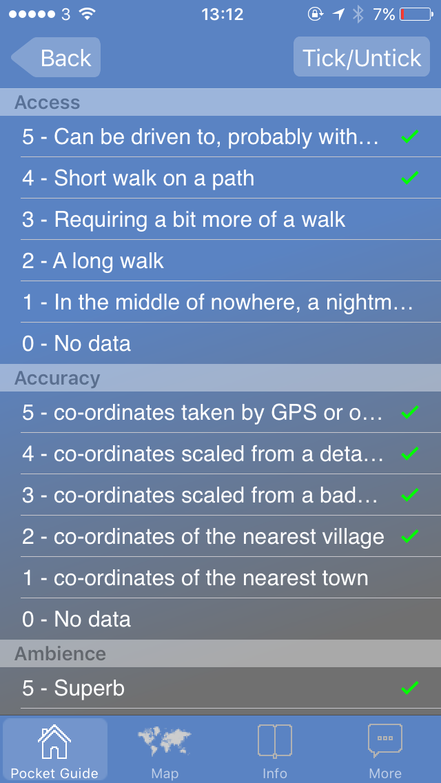
Other interesting categories within the 'Global filter' include 'Ambience' and 'Condition', two unashamedly subjective criteria which really emphasise the 'guiding' aspect of the app. In contrast to modern-era archaeological databases or gazetteers, which attempt to eschew the subjective experience of monuments, Pocket Guide Megaliths offers an entirely different, holistically visitor-focussed perspective. Knowing, for example, whether a recent infrastructure development has robbed a site of its tranquillity or that a site is either destroyed or impossible to access in a wheelchair in winter is vital within the context of making archaeology engaging and accessible for all. Users' Global Filter parameters (e.g. Long barrows in England with Ambience and Access scores of 3 and above) are passed through to the remaining options on the 'Pocket Guide' tab. These include several pre-defined 'views' that list sites in descending order according to their score within each category. This way it is possible to view a list of, say, the best condition or most accessible long barrows in England. The 'Pocket Guide' tab also features a search option which allows users to search by text within the already Globally-filtered database. The final main feature of this tab is the news feed, which displays a chronologically-ordered list of news posts and blog entries taken from the main MP website.
The 'Map' tab displays a Google-powered map showing the location of the sites within the database alongside the user's own, GPS-calculated location (Figure 4). A handy button allows the user to re-centre the map around their current location. By default, the map shows the location of every recorded site in the MP database, which allows users to marvel at its sheer scale and diversity. A switch to the top right of the map allows users to toggle their previously-defined Global filter on and off, a feature that can vastly reduce the number of points on the map, making it much easier to comprehend. In cases where there are still a rather large number of points, however, the map neatly clusters multiple nearby points into a single 'grouped point' when zoomed out.
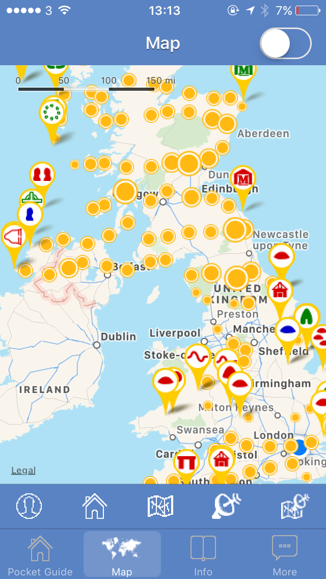
Different types of sites are displayed using different icons (Figure 4), which are themselves colour-coded to show whether the MP database carries photos for them (red — yes, green — no, please go and take one!). Again, these kinds of prompts are a useful illustration of the way the Pocket Guide Megaliths attempts to encourage its users to actually go out and contribute to the database. The icon designs are reasonably self-explanatory but users can quickly learn which icon represents which type of monument by tapping on them to reveal the name of the site and its typological classification. It's also possible to change the background mapping from a simplified map to satellite imagery, or a mixture of both.
Both the text-based and map-based views of the database allow users to home in on specific sites, which form the bulk of the app. Each site has its own page (see Figure 5) within the app which includes its user-assigned name, typological classification, score across various criteria (see above) and bearings in latitude and longitude. Where available, photos and a description of the site are also included. The quantity and type of information available for each site is reasonably variable and ranges from technical assessments to more creative, personal narratives about the purpose and significance of individual monuments. Additional options are available from within each site's individual page; users can bookmark the site within the app, view it on the MP website, instantly tweet about it using a purpose-built twitter button or save the provided images onto their device. Pocket Guide Megaliths also allows users to record private notes about each site in a simple text editor.

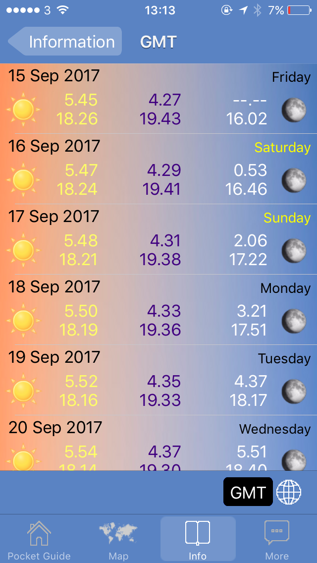
The third main tab of the app, 'Info', allows users to view a collated list of their bookmarked sites and any custom notes they have recorded. A wealth of practical information is also accessible here; a five-day weather forecast for both day and night, plus the timings for sunrise, sunset, twilight and moonrise for the next few months (Figure 6). Cleverly, the app adjusts these forecasts to match the location of the site last viewed, though users can easily change the forecast location by dropping a pin on a map within the forecasting pages themselves. Dates of the moon phases for both the northern and southern hemispheres are also available. The tab also contains a link to information regarding visiting sites featured in the app. The text on this page is taken from The Megalithic Portal Charter and outlines best practice when visiting archaeological sites. Useful reminders about not solely relying on electronic navigation devices is included but, importantly, the text also urges visitors to refrain from any activities that might put the site at risk or jeopardise future access to it. A series of additional tools and options are contained within the app's fourth main tab, 'More'. Here users can read guidance on how to use the app, install or update to the latest version of the MP database, or post notes to their own Facebook walls or Twitter accounts. The app also allows users to turn their device into a torch, compass or even a range finder, apparently capable of calculating the distance and height of nearby features.
Pocket Guide Megaliths unlocks the vast quantity of data held in the MP database and makes it accessible 'on-the-fly'. Its structure and aesthetic are geared more towards the initiated than the complete beginner (see below) and overall it reflects the impressive D.I.Y and community-driven ethos of its sister website The Megalithic Portal. Depending on the intended audience, there is some scope for improvement around usability or UX (user experience design). In particular, the default settings of the app could confuse users who are unfamiliar with databases or the MP in general. For example, any user who inquisitively taps on one the database views (e.g. Ambience view) before setting up their Global filter settings will be presented with an enormous, impossible-to-navigate list of nearly every site in the database ordered by their Ambience rating. The use case for this functionality is difficult to imagine and it would perhaps make more sense if the app took new users on a basic tour of the Global filter, allowing them to set parameters (Country, Site Type etc.) before offering them the option to view the database through the various category views. Alternatively, allowing users to 'skip down' the list to records beginning with each letter of the alphabet would help make the long list more digestible. The sheer size of the database can also make loading times within the app a little longer than users might be accustomed to.
As an application it has several stand-out features, one of which is the map and particularly its ability to synchronise with whichever record the user has last viewed. This makes understanding the context of individual sites in relation to their local monumental landscapes much easier. The granularity of the Global filtering system also offers powerful functionality for querying the database and isolating the records that interest users most. As already mentioned, the actual content of the database is a little variable in terms of detail and scope but, generally speaking, records always contain enough information to get a flavour of the site in question. Overall, the quantity of available data, the practical notes on how to access sites, weather forecasts and places to park etc. make the app the perfect practical companion for users who have decided to spend a weekend (or lifetime!) visiting megaliths.
Lake, M. 2012 'Open archaeology', World Archaeology 44, 471—78.
Rothenberg, M. 2017 'Review of Cadw Mobile App [application]', Internet Archaeology 44 https://doi.org/10.11141/ia.44.15
Internet Archaeology content is preserved for the long term with the Archaeology Data Service (ROR). Help sustain and support open access publication by donating to our Open Access Archaeology Fund.
Internet Archaeology is an open access journal based in the Department of Archaeology, University of York. Except where otherwise noted, content from this work may be used under the terms of the Creative Commons Attribution 3.0 (CC BY) Unported licence, which permits unrestricted use, distribution, and reproduction in any medium, provided that attribution to the author(s), the title of the work, the Internet Archaeology journal and the relevant URL/DOI are given.
Terms and Conditions | Legal Statements | Privacy Policy | Cookies Policy | Citing Internet Archaeology
Internet Archaeology content is preserved for the long term with the Archaeology Data Service (ROR). Help sustain and support open access publication by donating to our Open Access Archaeology Fund.