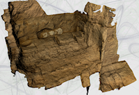
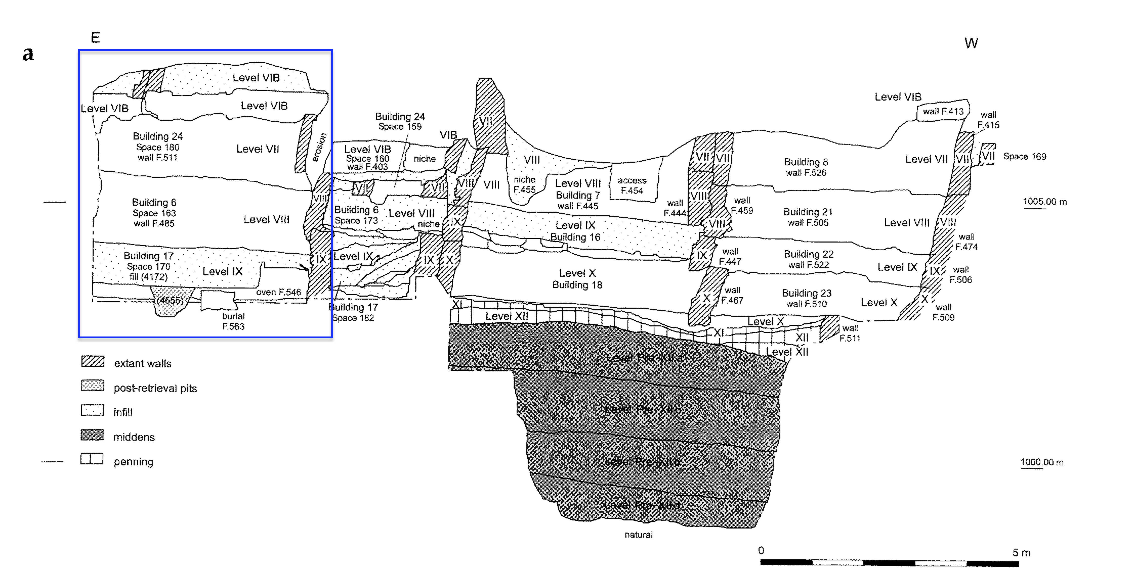
Figure 9: 3D model of the north room of Building 97 (generated by Julius Lundin), the west wall of Building 43, and the southern and south-eastern corner of Buildings 17, 6 and 24 (see also Figure 10). This sequence was particularly complex stratigraphically, and the section through this latter sequence of structures (a legacy of James Mellaart's 1960s' campaign), although stable, was particularly inaccessible due to its height. The section itself corresponds to drawings made by previous members of the current team in the 1990s (see Figure 10). However, an ongoing Bayesian dating project at the site required its stratigraphic re-evaluation in the 2012 field season. 3D 'structure from motion' capture of the section in the field (in this case initially processed at low resolution in the field, upon the tablets themselves), allowed the excavators not only to re-record the section from a digital source, but also to reinterpret it by being able to consider it from numerous perspectives that were not readily accessible from the ground or by ladder, and which were hard to derive from conventional 2D drawn records.
One of these datasets is based on the emergent 3D technologies that are rapidly coming to dominate many areas of the discipline. Since 2010, within the framework of the '3D-Digging Project' at Çatalhöyük (Forte 2014), a large number of 3D acquisition techniques have been tested during the excavation of Building 89 (south shelter) in order to evaluate the use of 3D models in support of archaeological practice (Forte et al. 2012; Forte et al. 2015). This included not only site-based data acquisition, but also the capture of finds and ecofacts as 3D models. Some of the results of this work were used by the ÇRP team to develop a series of protocols and implementation workflows relating to the use of image-based 3D-modelling techniques to document the excavation activity at different stages of the investigation process. The ultimate goal of this experimentation was always the integration of these new types of data within the site's digital archive (Berggren et al. 2015). This would build upon a high level of extant digital data integration within the project infrastructure, including the large corpus of data pertaining to the material culture of the site and the huge variety of environmental and scientific samples that all stored alongside the excavation data. This massive database of site information is all accessible from the tablets as the excavators are recording.
Figure 10: North-facing published section through South Area Sequence (from Farid 2007, 48); Buildings 17, 6 and 24 (highlighted by the blue box) are the focus of the 3D model in Figure 9 (from Farid 2007, 48).
For this reason, since 2013 the ÇRP team has systematically applied image-based 3D-modelling techniques to document buildings, spaces and features at different stages of the investigation. The project now has a series of protocols and workflows that deal not only with the acquisition of data, but also its integration within the site's digital archive. The result of this experimentation is that it is now possible to integrate low-resolution 3D models generated very quickly in the field into the intra-site GIS alongside the more conventional 2D data. In recent seasons this has been used to great effect to assess complex stratigraphy from angles that could not normally be accessed from the ground. For example, the sequence of Buildings 17, 6 and 24 in the South Area, which having previously been partially excavated by James Mellaart in his 1960s' campaign, and by the current project in the 1990s, was again reassessed and excavated in 2015 (Carpenter 2015). In this case the ability to generate 3D models quickly in the field proved useful to the excavator as a means to consider the complex and truncated sections and reinterpret many of the structural relationships (see Figures 9 and 10). The possibility of implementing and using 3D data within a GIS platform has offered a completely new avenue by which excavators can interact with the data that they collect, providing a powerful simulation environment in which it is possible to create a more accurate and holistic overview of the complex information retrieved on-site (Dell'Unto 2016).
Figure 11: Excavators Erik Johansson and Julius Lundin excavating what remained of the walls of Building 6 and 24 in section after digital re-recording in the 2012 field season (photograph by Jason Quinlan, courtesy of the Çatalhöyük Research Project). CC BY-NC 4.0
The technology itself (both hardware and software) improves from season to season, becoming more cost-effective, easier to use, and less time-consuming, making 3D field recording an increasingly viable option in archaeology (Doneus and Neubauer 2005; Callieri et al. 2011; Dellepiane et al. 2012; De Reu et al. 2013; Dell'Unto 2014; Opitz 2015; Opitz and Limp 2015; see also the project's own grey literature: Berggren 2014; Forte 2010; 2011; 2012; Forte and Lercari 2014; Forte et al. 2013; Forte et al. 2015; Issavi et al. 2016; Lercari and Lingle 2015; Lercari et al. 2016; Taylor and Issavi 2013; Taylor et al. 2012; Taylor et al. 2015). However, the real challenge as a project has been in designing a conceptual schema and theoretical research agenda to guide the implementation of this suite of technologies on site in the move from analogue/2D documentation to digital 2D/3D documentation. This 'migration process' has highlighted important questions such as: how will it augment existing modes of recording? What do 3D models add to our conceptualisation and understanding of the site? Can they lend something to the interpretative process? Given that there are associated logistical issues with 3D recording (time lags for post-processing, difficulties in splitting data, attributing metadata), one of the key challenges has been in trying to decide when it is appropriate to make a 3D acquisition: do we attempt stratigraphic 'unit by unit' level recording, or is it more useful to adopt a 'higher level' approach at a coarser granularity, focusing upon clusters of significant units (ie 'features'), or particular spaces and buildings? This last point, in particular, has been the subject of some debate within the project and remains an issue to solve.
Figure 12: Sequence of snapshots of 3D Geographic Information System of Çatalhöyük North Area made during the excavation season 2015. Specifically, a simulation of the temporal sequence of S490 (A), Space 488 (B) and Building132 (C), (photographic acquisition and 3D models: Jason Quinlan, Marta Perlinska and Nicoló Dell'Unto; 3D GIS Nicoló Dell'Unto)
However, the key fact is that whatever the minutiae of its application, 3D does have one huge advantage over more-traditional 'flat' 2D recording methodologies: it is highly visual, and thus quite evocative, allowing visualization with highly accurate geometrical detail. This in turn affords the possibility of keeping rigorous control of the measurement of spatial relations on site and generating simulations capable of combining contexts retrieved at different stages of the investigation (Figure 12). It seems likely then that it has significant potential to impact the interpretative process, particularly if the model can be turned around fast enough to be used in the field upon the tablets. Figure 7 and Figure 15 both show how the 3D field acquisitions at Çatalhöyük can be integrated directly alongside 2D data in the GIS. Given that there remains an active discourse upon the site about when it is appropriate to document the archaeology in 3D, the project has, to date, been very flexible in when it actually generates 3D models.
Figure 13: 3D data acquisition on site by Nicoló Dell'Unto (photograph by Jason Quinlan, courtesy of the Çatalhöyük Research Project). CC BY-NC 4.0
Full integration into the intra-site GIS has the additional advantage of allowing the 3D data to be viewed alongside more conventional 2D plan data. As the post-processing time continues to decrease each season, so the models increasingly find their way onto the tablets within a much shorter timeframe. This is proving to be a powerful tool in the visualization and contextualisation of our graphic archive in the field. Already within the GIS there is no real need to physically overlay endless single context plans – excavators now have almost instant access to contextual, 'multi-unit' plans that can be generated on the fly without compromising the single context methodology (stratigraphic/temporal control is thus retained). The 3D models add an extra dimension to this mode of visualization, and can also be used to generate orthogonalised photographs quickly, working together with the GIS to create a very interesting form of visual tool. With this in mind, it is worth emphasising that the vision here is of a mode of 3D recording which augments the other recording methodologies, and it should in no way be seen as a replacement. In fact, used in this way the 3D technologies can be regarded as the flip-side of the recording coin. Conventional graphical recording (digital or otherwise) can be seen as highly interpretative, whereas 3D models in this system are very sophisticated snapshots of the excavation process which can complement the recording process. But it doesn't end there, since 3D technologies undoubtedly have huge potential to contribute to the interpretative process as well; indeed, 3D models are already proving to be a crucial element of interpretation (Lingle et al. 2015). However, at this phase in their implementation at Çatalhöyük the project is still only scratching the surface of this potential.
Figure 14: 3D models of Building 131 displayed in the 3D GIS. The system is visualized using a tablet PC Microsoft Surface 3
Internet Archaeology is an open access journal based in the Department of Archaeology, University of York. Except where otherwise noted, content from this work may be used under the terms of the Creative Commons Attribution 3.0 (CC BY) Unported licence, which permits unrestricted use, distribution, and reproduction in any medium, provided that attribution to the author(s), the title of the work, the Internet Archaeology journal and the relevant URL/DOI are given.
Internet Archaeology content is preserved for the long term with the Archaeology Data Service (ROR). Help sustain and support open access publication by donating to our Open Access Archaeology Fund.


