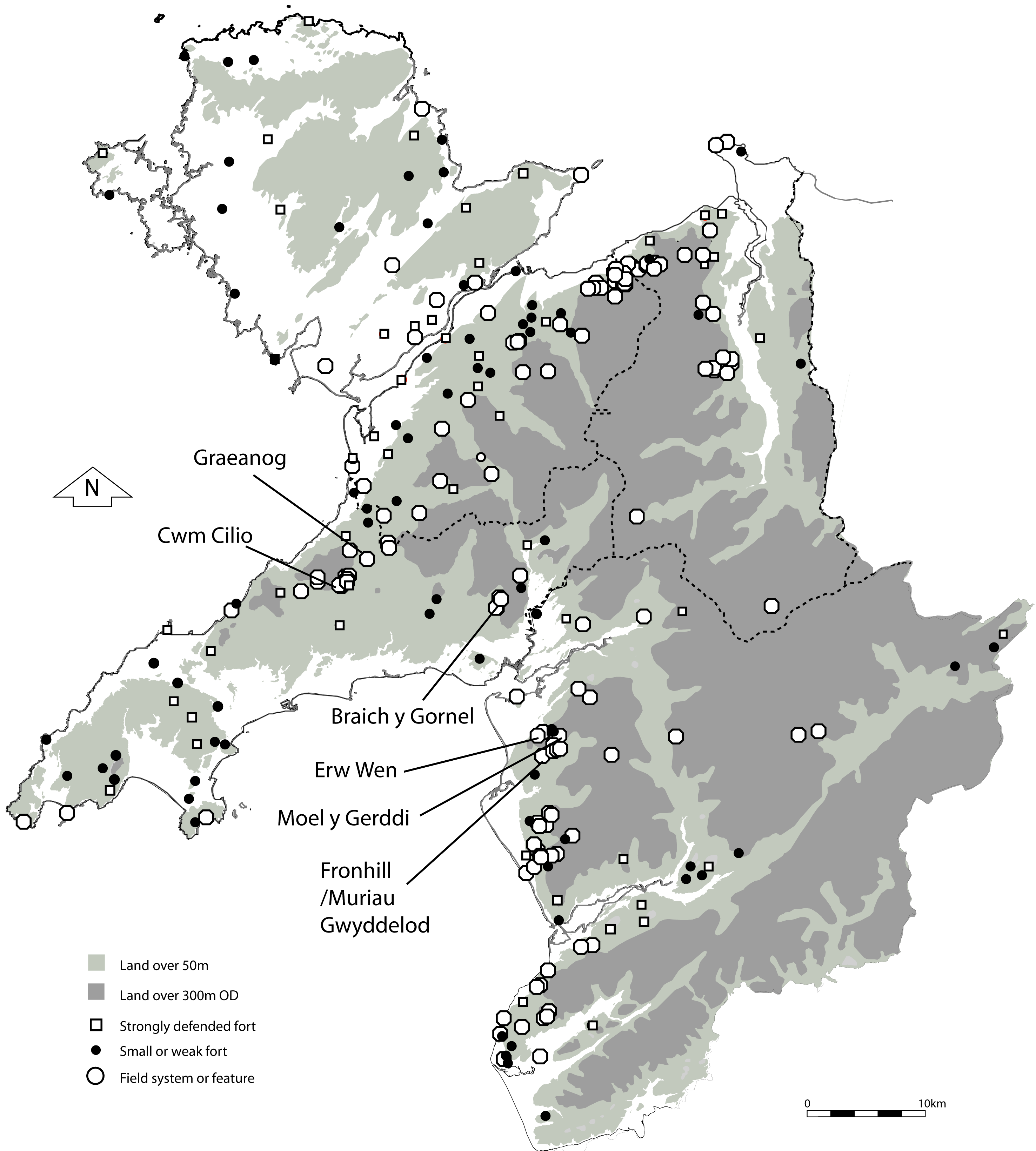
This work was carried out by Gwynedd Archaeological Trust (GAT) for Cadw to allow better understanding and management of extensive early field systems. A considerable number of such early field systems exist in north-west Wales and several, such as those around Moel Faban, Llanllechid, near Bethesda (RCAHMW 1956, 138–147) have been surveyed by the Royal Commission on Ancient and Historic Monuments in Wales (RCAHMW). The majority of recorded examples, along with settlement remains, are found on the fringes of the uplands where they have escaped modern clearance or cultivation (Figure 1). Although a good number of settlement remains have been excavated, such as those at Moel y Gerddi and Erw Wen, near Harlech, Meirionnydd (Kelly 1988) and at Graeanog, south of Caernarfon (Fasham et al. 1998) there has been little study of any associated fields. Where early fields survive, most are associated with settlement features that indicate an Iron Age or Romano-British date. The location of such field systems and of their associated settlements has been shown to be largely determined by their topography and soils (Johnson 1978). However, most field systems also show evidence of a further period of re-use and modification in the medieval period before abandonment. Although these field systems are of various morphological types and patterns, the project was focused on areas of sub-rectangular fields of probable Iron Age type. The field systems are recognizable typically as enclosures with low stony banks and it is uncertain whether these were functional enclosures with built walls or perhaps hedges or merely field stone clearance dumps. Some fields incorporate considerable lynchet development and it was hoped that the study would help to understand their origins. Furthermore, palaeoenvironmental work associated with early field systems has also been a largely neglected area of study in Wales compared with other areas in Britain and Ireland (e.g. Smith et al. 1996; Long et al. 1998; Fyfe et al. 2008; Verrill and Tipping 2010a, Verrill and Tipping 2010b). Hence another aim was to identify buried soils to provide dating and environmental evidence relating to prior cultivation or perhaps clearance episodes. Geophysical survey, by fluxgate gradiometer, was also used, to look for additional features such as cultivation marks, along with background palaeoenvironmental study of nearby peat deposits.
The RCAHMW recognized two main types of prehistoric field systems in north-west Wales: those with small, sub-rectangular enclosed terraced fields and those of curvilinear design with no obvious terracing. The sub-rectangular fields are generally dated by association with nearby roundhouse settlements known to have been occupied in the Romano-British period but likely to have originated much earlier. The curvilinear fields were believed to be of Bronze Age date by comparison with similar field systems on Dartmoor but this was not substantiated by the subsequent investigation of settlement associated with such fields at Crawcwellt, Meirionnydd (Crew 1989). The physical remains of the earliest agriculture are rare and fragmentary as a result of the millennia of subsequent landscape usage. The research here aimed to consider the evidence from a variety of perspectives by looking at the palaeoenvironmental record from peat close to surviving early known field systems and by radiocarbon dating, palaeoenvironmental and micromorphological evidence from soils buried by field boundaries. Additionally, as well as elucidating the environmental histories of the areas concerned, and in particular any land use changes associated with the field systems, the pollen records from Cwm Cilio and Braich y Gornel potentially provided an opportunity to see if there was evidence for spatial variation in vegetation history and land use within the region. In fact, the palaeoenvironmental results provide the basis and most significant part of the evidence presented here. The use of geophysical survey to identify early cultivation features was a new approach and the archaeological excavations were undertaken principally as a means of providing samples for dating and analysis. Only an abbreviated version of the excavation results is presented here. The full details are presented in the in-house site archive report (GAT Report No. 933), along with details of the radiocarbon dating, palaeoenvironmental and soil micromorphology results and pollen core stratigraphies (Smith et al. 2011).
Internet Archaeology is an open access journal based in the Department of Archaeology, University of York. Except where otherwise noted, content from this work may be used under the terms of the Creative Commons Attribution 3.0 (CC BY) Unported licence, which permits unrestricted use, distribution, and reproduction in any medium, provided that attribution to the author(s), the title of the work, the Internet Archaeology journal and the relevant URL/DOI are given.
Terms and Conditions | Legal Statements | Privacy Policy | Cookies Policy | Citing Internet Archaeology
Internet Archaeology content is preserved for the long term with the Archaeology Data Service (ROR). Help sustain and support open access publication by donating to our Open Access Archaeology Fund.