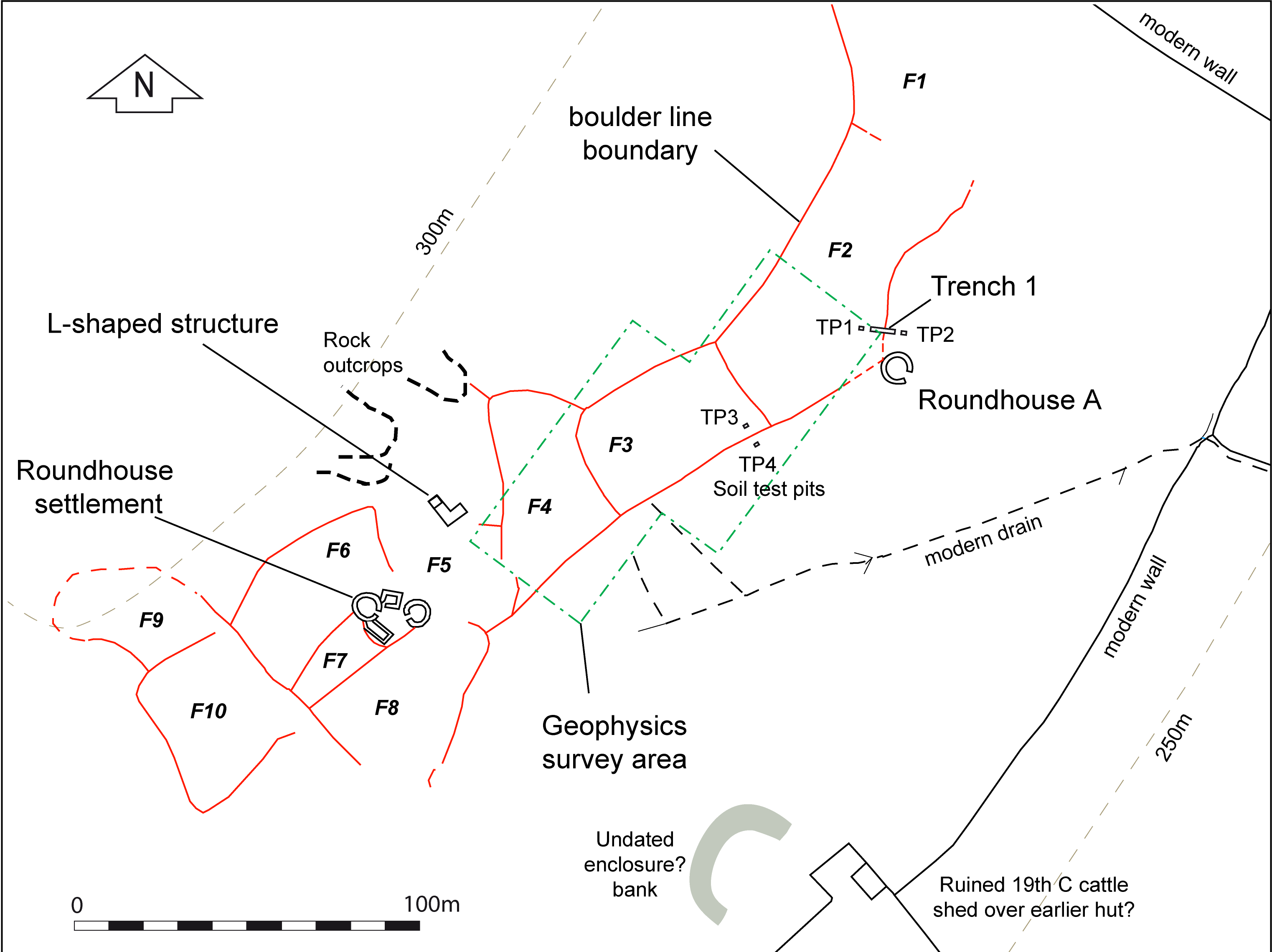
One trench, 6m by 1.6m in area, was excavated across a field boundary about 5m upslope from the outlying roundhouse A. The boundary lies at the lower edge of a field enclosure (F2), which continues to the north-east but the whole extent of which cannot be traced. The location for the trench was chosen because the boundary was in relatively good condition and showed some slight terracing, which was absent from other boundaries. There was therefore some potential for surviving stratigraphy and environmental information, while the proximity to roundhouse A provided the possibility of some associated cultural and dating evidence.
The boundary here ran approximately along the contour towards roundhouse A, becoming lower and indistinct about 4m from the wall of the house. Another similar boundary approached the house from the opposite side on a different angle, again becoming indistinct on the surface before reaching the house. These two boundaries were clearly aligned on the house, indicating that they were contemporary with or later than the house (Figure 10).
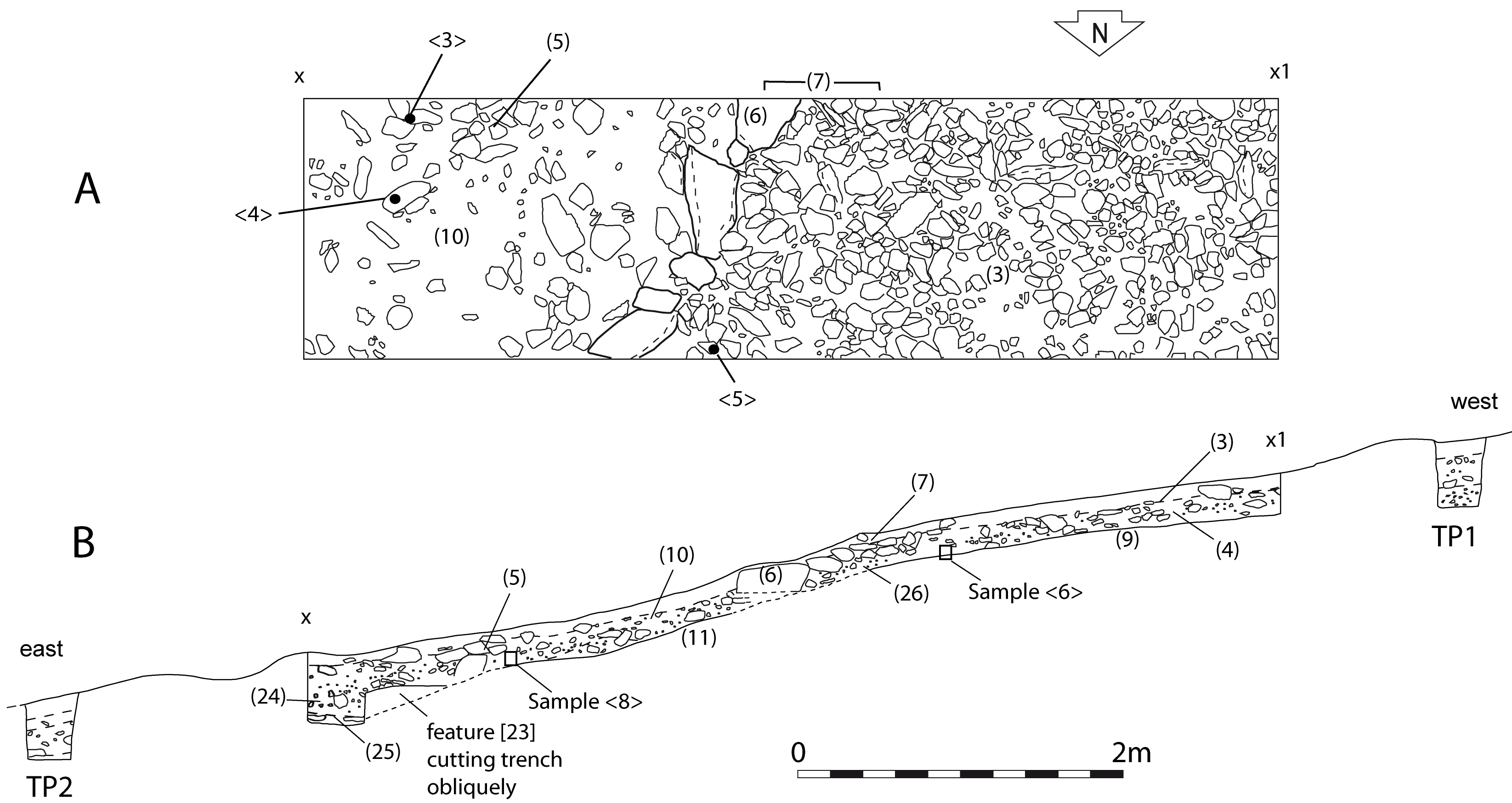
The boundary was visible on the surface as a line of large, irregular glacial boulders (6), with a slight raised terrace on its upslope side. In places some of the boulders seemed to have slipped down the slope out of the boundary. Others, still in situ, showed some evidence that they had been positioned so as to create a (discontinuous) front 'face' for the boundary. In the terrace area upslope from the boundary the topsoil proved to be very shallow and overlaid a fairly continuous horizontal layer of small stones (Figure 12, 3). The stony layer 3 is interpreted as a worm-sorted horizon at the top of a deeper soil, (4), which was a friable, mid- to dark brown mixed stony soil about 0.2m deep. This lay over the natural subsoil of slightly compact orange-brown stony silt (9). Immediately upslope of the main boundary boulders (6), and forming the bulk of the boundary, was a layer of smaller stones (7). Beneath these was a layer (26), similar to (4) and most likely a continuation of it, which was therefore likely to be a remnant of soil contemporary with the boundary use or construction; this contained some charcoal.
Downslope from the boundary was layer (5), of stones similar in size to those of (7). These stones overlaid layer (10), a mid-brown silt with yellow-brown mottles overlying the subsoil (11). Layer (10) contained two pieces of charcoal, one of which was submitted for radiocarbon dating.
The facing stones (6) were embedded in the subsoil with no actual buried soil underneath them. However, two of the 'facing' stones had slipped downslope, and one overlay a humic layer (13), possibly a former turf surface; this was sampled for possible pollen analysis (samples 7 and 11). Other small block samples were taken from layers (4) (sample 6) and (10) (sample 8) for possible soil micromorphological analysis. Two small soil test pits (TP1 and TP2 on Figure 10) were excavated upslope and downslope from the trench and these showed a continuation of the same stratigraphy.
A further two small soil test pits were also excavated, one upslope and one downslope from the field boundary bank at the lower edge of field F3 to the west (Figure 10, TP3 and TP4). This was sub-rectangular and the most regular-shaped of the fields here. The small size and regular shape suggests a planned design appropriate for cultivation although there was negligible surface evidence of terracing at the lower edge of the field. This lower boundary lay at the bottom of the hill slope with more level, marshy land to the south-east. The test pits were designed to compare the depth and type of soil within the field with that immediately outside it. TP3, located within the early field, showed a stony layer above a silty loam to a depth of 0.2m above orange-brown clayey subsoil, a similar stratigraphy to that found in Trench 1. In contrast, TP4, outside the field, revealed deep, undisturbed topsoil over a stony horizon which lay directly over the orange-brown subsoil. There seemed a good indication, therefore, that there had been some cultivation, or at least different land use, of the area within the field as compared to outside the field.
Internet Archaeology is an open access journal based in the Department of Archaeology, University of York. Except where otherwise noted, content from this work may be used under the terms of the Creative Commons Attribution 3.0 (CC BY) Unported licence, which permits unrestricted use, distribution, and reproduction in any medium, provided that attribution to the author(s), the title of the work, the Internet Archaeology journal and the relevant URL/DOI are given.
Terms and Conditions | Legal Statements | Privacy Policy | Cookies Policy | Citing Internet Archaeology
Internet Archaeology content is preserved for the long term with the Archaeology Data Service (ROR). Help sustain and support open access publication by donating to our Open Access Archaeology Fund.