A summary is provided here. The full survey description is to be found in the in-house report (Smith et al. 2011).
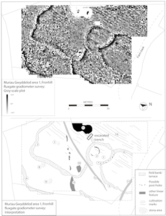
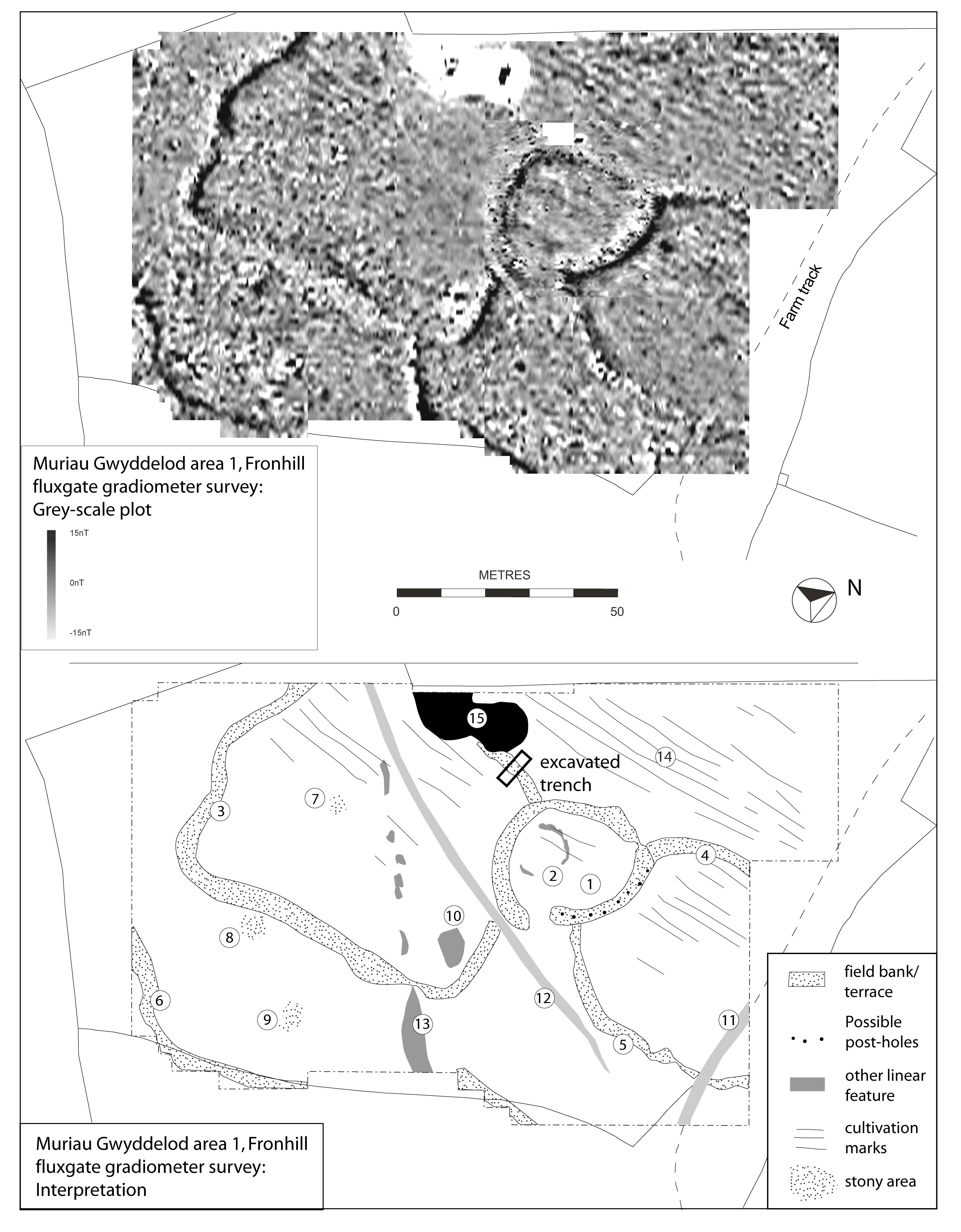
Most of the area was surveyed with readings every 0.25m along traverses 1m apart but the central enclosure, interpreted as a possible settlement, was surveyed at a higher resolution of readings every 0.25m along traverses 0.5m apart. The two surveys were then combined (Figure 16). An electricity pole and stay-cable masked an area at the west side (15).
The central enclosure is oval, 25m by 28m internally, with a stony bank and an entrance gap on the south-eastern side. A line of fairly evenly spaced anomalies along the eastern bank may indicate post-holes or a line of large stones. The interior of the enclosure shows no clear signs of habitation but a faint, roughly circular anomaly (2), c.11m diameter, could indicate the walls of a roundhouse although there are no anomalies that might suggest a hearth, which would be expected to have been present if it was a house.
The stone banks and walls elsewhere on the survey produced very clear anomalies, with stronger positive anomalies on the uphill side, perhaps as a result of deposition of more magnetic soil or iron panning. The banks delineate fields radiating from the central enclosure. The anomalies produced by these earthworks are generally well-defined, indicating good sub-surface preservation. Three upstanding clearance cairns produced only slight anomalies (7–9), while a similar anomaly (10) could indicate further stone dumping. Two linear anomalies (11–12) indicate trackways, both modern. Another linear anomaly (13) is difficult to interpret and is possibly a modern water pipe.
The survey did show up linear cultivation marks or possible ridge-and-furrow (14) at a spacing of 2.5m but this crosses most of the area and it clearly runs over the early field banks. However, at the west side it pre-dates the existing, probably 19th-century, field wall and may relate to widespread clearance prior to the construction of the present system of large rectilinear fields.
The survey area was laid out to include most of the central enclosure and part of an adjoining field. The survey was difficult, crossed by low walls overgrown with gorse and brambles. The survey was carried out at high resolution (readings every 0.25m along traverses 0.5m apart) using guide lines and a very slow traverse speed. The topsoil was stony and appeared to be shallow and much of the survey was dominated by fairly high levels of noise probably caused by the amount of stone present.
The stony enclosure bank produced a clear anomaly that was quieter than its surroundings, perhaps because it contained a higher proportion of earth, rather than stone. Two other anomalies corresponded to lower walls. The north-western half of a roundhouse also produced a clear anomaly, with the spread wall showing as an area of increased noise and the interior as a negative anomaly. A small part of two very narrow linear anomalies were detected at the south-west side.
The interior of the central enclosure produced no useful results, providing no support for the idea that this was originally a settlement area. However, there are several clearance cairns within the enclosure, which may indicate that there were once other features that have since been cleared.
The Fronhill enclosure has relatively well-preserved and substantial early boundaries which suggested that they might overlie buried soils. The location chosen for the excavation was a boundary attached to, and about 12m south-west of, the central possible settlement enclosure. It was a substantial stony boundary with an upslope terrace over 1m in height, with boulders protruding from its downslope face and topped by a distinct line of larger boulders.
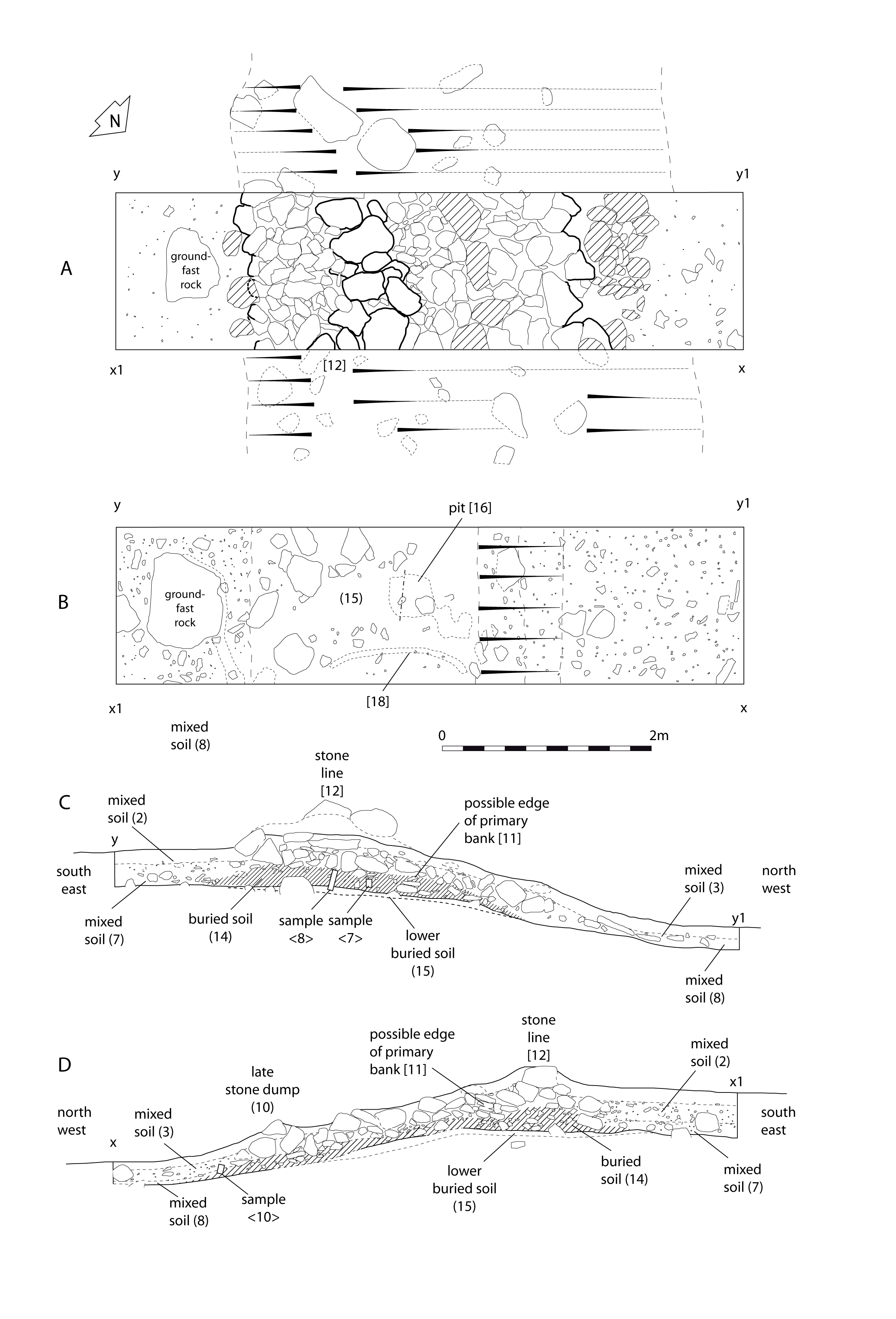
A trench 6m by 1.5m was excavated across the boundary (Figure 17). Removal of the topsoil exposed a stony bank with a fairly distinct edge on the uphill side, a line of boulders (12) along its crest and a vague edge along its downhill side. Excavation showed the bank to consist of a core of small angular and sub-angular stones lying on a fairly level surface and spreading down a slightly steeper slope that dipped to the west. Larger sub-angular boulders had been added to the original core at a later stage in its existence. Some of the original smaller stones had been laid horizontally at the west, suggesting that the bank had originally been faced or at least deliberately edged on its west, downhill side.
Removal of the stony bank exposed a buried soil (14), c.0.20m deep, of friable, mid-brown silt with a scatter of small stones. This buried soil extended down the slope beneath the stones of the bank, thinning out and ending at the foot of the slope. An equivalent horizon extended to the east beyond the bank but was much stonier, perhaps as a result of cultivation.
Removal of the buried soil (14) revealed a lower stratum of almost stone-free, buff-brown sub-soil (15) which contained a few pieces of charcoal. This layer was only present in the centre of the trench beneath the original part of the stony bank, suggesting that it once extended further and had only survived where it had been preserved by the bank. A piece of charcoal from this layer was submitted for AMS radiocarbon dating. Cut into this layer was a small sub-circular pit (16) 0.40m diameter and 0.16m deep, the fill of which was dark and humic and contained a few pieces of charcoal. One of these was submitted for AMS radiocarbon dating. Lying on the base of the pit was a thin flat stone, interpreted as possibly a pad-stone for a post. There were two other areas of darker soil, both quite shallow, one linear (18), suggesting that they resulted from animal or root action. Soil samples for possible analysis were taken from the buried soils (14) and (15).
Internet Archaeology is an open access journal based in the Department of Archaeology, University of York. Except where otherwise noted, content from this work may be used under the terms of the Creative Commons Attribution 3.0 (CC BY) Unported licence, which permits unrestricted use, distribution, and reproduction in any medium, provided that attribution to the author(s), the title of the work, the Internet Archaeology journal and the relevant URL/DOI are given.
Terms and Conditions | Legal Statements | Privacy Policy | Cookies Policy | Citing Internet Archaeology
Internet Archaeology content is preserved for the long term with the Archaeology Data Service (ROR). Help sustain and support open access publication by donating to our Open Access Archaeology Fund.