As the discussion of chronology indicates, long barrows are not the only Early Neolithic monuments that need to be considered here. The causewayed enclosure at Robin Hood's Ball, probably begun in the late 37th or early 36th century cal BC (Healy et al. 2011, 197), presumably had substantial upstanding earthworks commensurate with its 2.5m-deep (inner) ditch, although it remains uncertain to what extent the freshly quarried chalk would have been masked by wooden revetments (Thomas 1964, fig. 3). In a classic fashion for lowland-orientated examples of such monuments, the enclosure occupies sloping ground just below the summit of a low rise, giving the monument a restricted viewshed that takes in a broad arc between north-east and south-west (Oswald et al. 2001, fig 1.4). In an unwooded landscape, a number of long barrows in the SWHS would potentially have fallen within this viewshed, including FIG31, only 0.5km to the east and NET6, 1.2km to the north-east, while the summit to the north-west of the enclosure may have afforded more panoramic views.
Perhaps a more appropriate way of thinking about the visibility of monuments is in terms of movement around the landscape. The journeys that transhumant people and their livestock presumably made to causewayed enclosures may have passed within sight of a number of burial monuments, some perhaps deliberately stationed along drove-paths (Edmonds 1999, 65; Loveday 2006). Robin Hood's Ball and FIG31 both seem to be intended to be seen by people emerging from the dry valley that leads up from the River Till, while the two long barrows to the north-east (NET6 and NETB) seem to relate similarly to a dry valley that begins at Netheravon. In this pattern, we may detect the interaction of different communities that has, from the time of Curwen (1930) onwards, been seen as one of the key functions of causewayed enclosures.
We now know that Robin Hood's Ball, like many other causewayed enclosures, had a neighbour. The recently discovered single-circuit causewayed enclosure at Larkhill, just outside the SWHS, is another example of a lowland-orientated monument. Here too, the highest part of the perimeter (as yet unplotted) seems likely to have barely touched the high point of the tip of the spur on which it sits, so that the interior decisively occupies sloping ground. This again gives the monument an apparent orientation, broadly towards the valley of the River Avon, but more specifically towards the head of a dry valley that seems likely to have offered a relatively gentle path from the valley floor for both livestock and their herders. Long barrows immediately to the west and north-west of Larkhill (DUR24 and FIG27) and adjacent to the river near Woodhenge (DUR76) were probably not intervisible with the enclosure, and appear to have been sited so as to be perceived from separate parts of the landscape, broadly to the south-west.
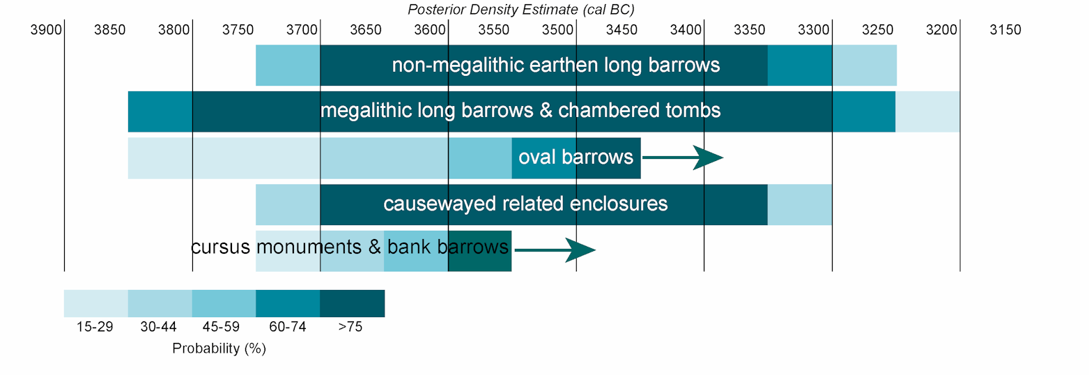
Assuming that the long barrows and causewayed enclosures were broadly contemporary (see Figure 13), we might tentatively suggest that they collectively marked routes established through customary practice, perhaps related to livestock management. Monuments may have formalised or commemorated movements and gatherings of different scale, though the emphasis on localised patterns of visual perception perhaps relates to movements around the landscape at a community scale.
In summary, Early Neolithic monuments appear to have been carefully and deliberately sited in such a way that they took advantage of, and often reflected, natural topographic forms, and regularly appear to be located so as to command views to and from other places of significance, such as contemporary monuments or valley heads (Field 2006, 102–111). Although relationships with topography can be quite confidently considered because of the lack of major topographic change in the landscape since the Early Neolithic, assessing relationships of visibility, particularly intervisibility between monuments as we attempt above, is considerably more problematic, both in terms of the lack of environmental evidence from most sites and other areas of the landscape, and in terms of some of the underlying assumptions of the approach. For example, does evidence for the development of long grass around a long barrow (as at WS71) indicate abandonment, regeneration following clearance, or a deliberate lack of grazing due to reverence for the monument? How relevant is the static, point-to-point measurement of visibility to people who moved around the landscape in the course of everyday life? Finally, few studies of intervisibility take account of the relative chronology of long barrows, a key issue when attempting to elucidate the motivations for the selection of locations for the construction of long barrows in terms of their interrelationships.
The frequent focus on topography in this and other long barrow studies also fails take into account the possible importance of impermanent natural features in the location and alignment of the long barrows. Cummings and Whittle (2003) have speculated that certain monuments of this period may have been placed in relation to ancient trees, and cite considerable ethnographic and archaeological evidence for the diverse symbolic roles of trees in pre-modern societies. Whether or not ancient trees of symbolic importance existed within the SWHS during the Early Neolithic remains a moot point. But we would suggest that not only trees, but many features of open environments could have played an active role in both the siting of long barrows and how they were experienced. These might include the colour of the vegetation, the noise of insects and birds, smells of fragrant herbs and the sense of movement imparted by the long grassland in the wind. Grassland or 'parkland' could obscure, reveal, impede, or overgrow to alter interaction with the monument, and the ways in which grassland was used by communities would surely have fundamentally affected the perception and use or disuse of the monument which it surrounded. Potentially, grassy spaces could long have retained physical evidence of much earlier episodes of woodland clearance, or could have recalled the grazing rights of ancestors, real or otherwise. The material qualities of the monuments themselves would also considerably affect perceptions on a landscape scale. Long barrows were large linear features, often capped with chalk that would have appeared bright white in colour and drawn the eye, at least when freshly constructed. In this and many other ways they evoked associations between the materials, places and people with which their histories were entangled.
Internet Archaeology is an open access journal based in the Department of Archaeology, University of York. Except where otherwise noted, content from this work may be used under the terms of the Creative Commons Attribution 3.0 (CC BY) Unported licence, which permits unrestricted use, distribution, and reproduction in any medium, provided that attribution to the author(s), the title of the work, the Internet Archaeology journal and the relevant URL/DOI are given.
Terms and Conditions | Legal Statements | Privacy Policy | Cookies Policy | Citing Internet Archaeology
Internet Archaeology content is preserved for the long term with the Archaeology Data Service (ROR). Help sustain and support open access publication by donating to our Open Access Archaeology Fund.