This small fortified site lies on an isolated, rounded hill-top in the far west of the Llŷn peninsula with prominent views overlooking the whole of the western end of the peninsula. It belongs to the group of defended sites described here as a 'lightly defended bivallate (double-banked) enclosure'. It is important as it is the only one of this type to have been excavated and to have produced artefactual, stratigraphic and dating evidence.
The site survives as earthworks, showing enclosure banks and house platforms (Figure 4). Some of the houses were excavated in 1929 (Breese 1932). These produced flint and stone tools and some crude undiagnostic pottery but no firm dating evidence, and it came to be believed that the site was of early medieval date. However, further excavations carried out in 1958 and 1959 by Leslie Alcock (1960) showed that the fort was of prehistoric date and that it began as the earliest occupation of such a site in this area that had been identified.
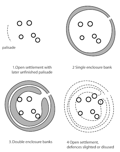
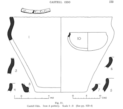
Four phases of settlement activity were identified by Alcock (Figure J). The first phase consisted of an unenclosed hill-top settlement of at least two timber-walled roundhouses, each probably of about 9m diameter. Charcoal from this phase of settlement produced three radiocarbon dates centring between the 6th to 3rd centuries BC. Exceptionally for this area, this phase of settlement also produced pottery of a style that accords with the radiocarbon dates (Figure K). The end of this phase was indicated by the start of construction of a timber palisade around the settlement but this was burnt down before completion. There then appeared to have been a period of abandonment.

The second phase was marked by construction of a fairly insubstantial enclosure bank produced by shallow quarrying rather than by excavation of a ditch. In the third phase the original bank was enlarged and reinforced with stone revetments and a second bank was constructed within the original enclosure, reducing the size of the available settlement area but adding to its defensive strength. In the fourth and final phase the defensive banks became disused or were deliberately levelled and several stone-walled roundhouses were built, two of which extended over the remains of the inner bank. This last phase, when the settlement was effectively undefended, produced no datable artefacts or radiocarbon dates but it was suggested that the abandonment or demolition of the defences may have happened as a result of the Roman subjugation of the area.
Castell Odo is important as it shows that seemingly simple sites can have complex histories, something that is not apparent from the visible remains. Geophysical surveys of other similar sites in the area suggest they may have equally complex histories. The presence of a group of similar sites relatively close together in Llŷn may show some cultural affinity between them, and somewhat different from defended enclosures around the Snowdonia uplands to the east.

Internet Archaeology is an open access journal based in the Department of Archaeology, University of York. Except where otherwise noted, content from this work may be used under the terms of the Creative Commons Attribution 3.0 (CC BY) Unported licence, which permits unrestricted use, distribution, and reproduction in any medium, provided that attribution to the author(s), the title of the work, the Internet Archaeology journal and the relevant URL/DOI are given.
Terms and Conditions | Legal Statements | Privacy Policy | Cookies Policy | Citing Internet Archaeology
Internet Archaeology content is preserved for the long term with the Archaeology Data Service. Help sustain and support open access publication by donating to our Open Access Archaeology Fund.