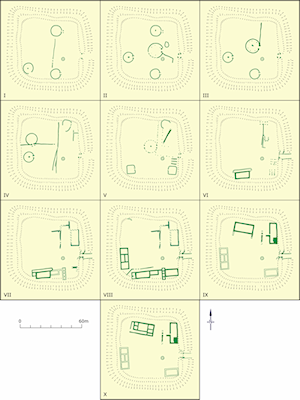

Whitton, excavated by the University of Cardiff in the 1960s (Jarrett and Wrathmell 1981), is one of the few rural sites in South Wales that have been examined in their entirety (Figure H). The site probably began in the first half of the 1st century AD as a group of roundhouses defended by a bank and ditch (Figure J). The bank had been badly damaged by ploughing, but the ditch was about 4m wide at the top and 2m deep. There was one entrance, on the east side, with a causeway across the ditch leading through a gap in the bank where a sequence of timber gateways was excavated. The earlier gates were probably surmounted by timber towers, but later the bank seems to have gone out of use as a defence (although was still the boundary), and the towers were replaced by simple gates.

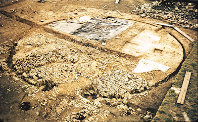
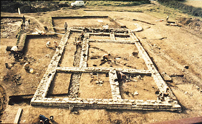
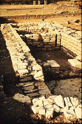
The defences enclosed an area of about 60m by 56m, with a well. The earliest buildings were a succession of roundhouses with the largest in the middle. The walls were represented by trenches which had been packed with clay and stones, and probably originally held timber uprights set edge-to-edge. The two largest houses also both had an internal ring of posts that would have helped to support the roof. Other structures included a couple of sub-square buildings of approximately the same size as the smaller roundhouses, and buildings founded on a grid of posts, probably granaries. The interior of the enclosure was divided at various times by fence-lines. The excavators calculate from modern studies on how fast timbers decay in the ground that none of these buildings, individually, is likely to have lasted for more than 20 years, but it was not until nearly the middle of the 2nd century that the first rectangular buildings with stone foundations began to be constructed. The earliest of these overlapped with use of the latest timber buildings. The best-understood early stone building started as a simple single room cut into the southern boundary bank, but was later extended with the addition of a veranda on one long side, then a sunken room on one short end (possibly intended for a hypocaust but not completed; Figure K, Figure L), followed by a suite of rooms on the other end with another hypocaust which was, however, never fired. It may have been replaced as the main residential building by another stone building constructed against the western bank, whose foundations suggest it may have been two storeys high. By the end of the 3rd century a stone building with a corndryer and a cistern had replaced the poorly understood structures against the eastern boundary bank, and a new house, again probably two storeys and with a corridor or veranda, was built on the northern side.

We see here the development of a defended enclosure with typical Iron Age roundhouses to a villa with stone houses in the Roman tradition, complete with tiled roofs and wallplaster, but still respecting the line of the bank. Finds suggest that cattle-raising was more important than sheep, goats or pigs and that emmer wheat was grown. A wide range of pottery shows that the inhabitants were firmly integrated into the market economy.

Internet Archaeology is an open access journal based in the Department of Archaeology, University of York. Except where otherwise noted, content from this work may be used under the terms of the Creative Commons Attribution 3.0 (CC BY) Unported licence, which permits unrestricted use, distribution, and reproduction in any medium, provided that attribution to the author(s), the title of the work, the Internet Archaeology journal and the relevant URL/DOI are given.
Terms and Conditions | Legal Statements | Privacy Policy | Cookies Policy | Citing Internet Archaeology
Internet Archaeology content is preserved for the long term with the Archaeology Data Service. Help sustain and support open access publication by donating to our Open Access Archaeology Fund.