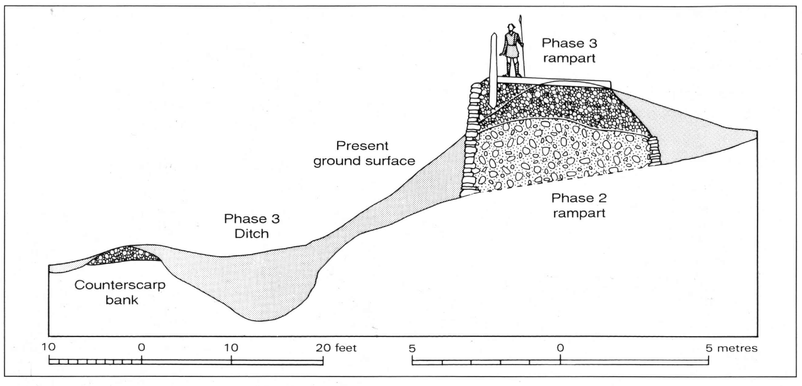
Figure 1: A reconstructed section through the defences of Pen Dinas, Aberystwyth. Where hillfort defences have collapsed and slumped over 2,000 years or more, the present-day earthwork profile may retain the height of the rampart at its summit (right), but will give little impression of the original appearance of standing walls and excavated ditches. At upland sites where soil accumulation is limited, it is still possible to find rampart and ditch profiles far better preserved, even with stone rampart-facing intact (Image: Crown Copyright RCAHMW)
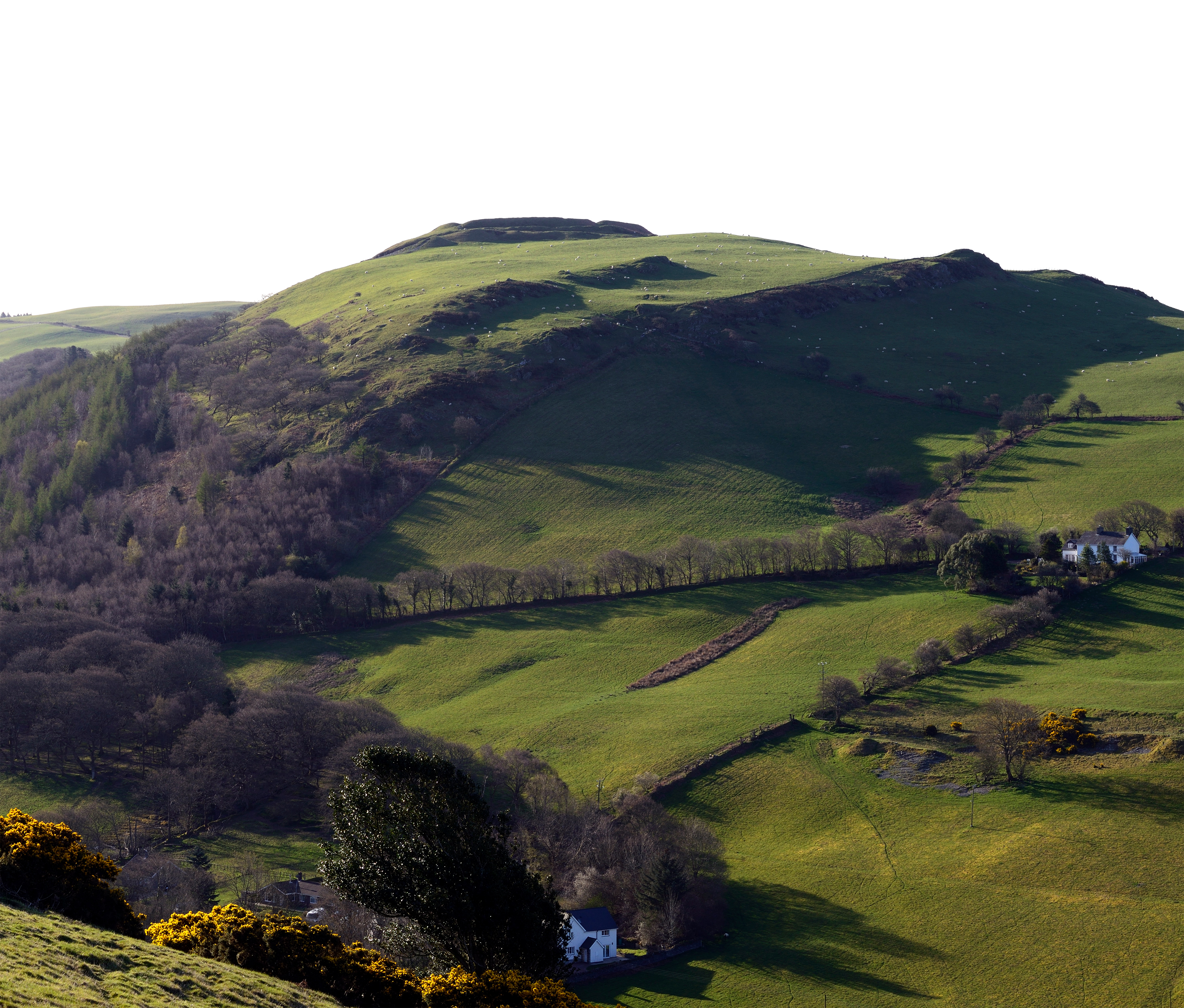
Figure 2: The power of place: the ramparts of Darren Camp, Ceredigion, crowning the summit of a prominent hill, are augmented by forward-facing natural escarpments of outcropping rock (right) which accentuate the appearance of strength and impregnability of the prehistoric fort as visitors approach uphill from the west (Image: T. Driver).
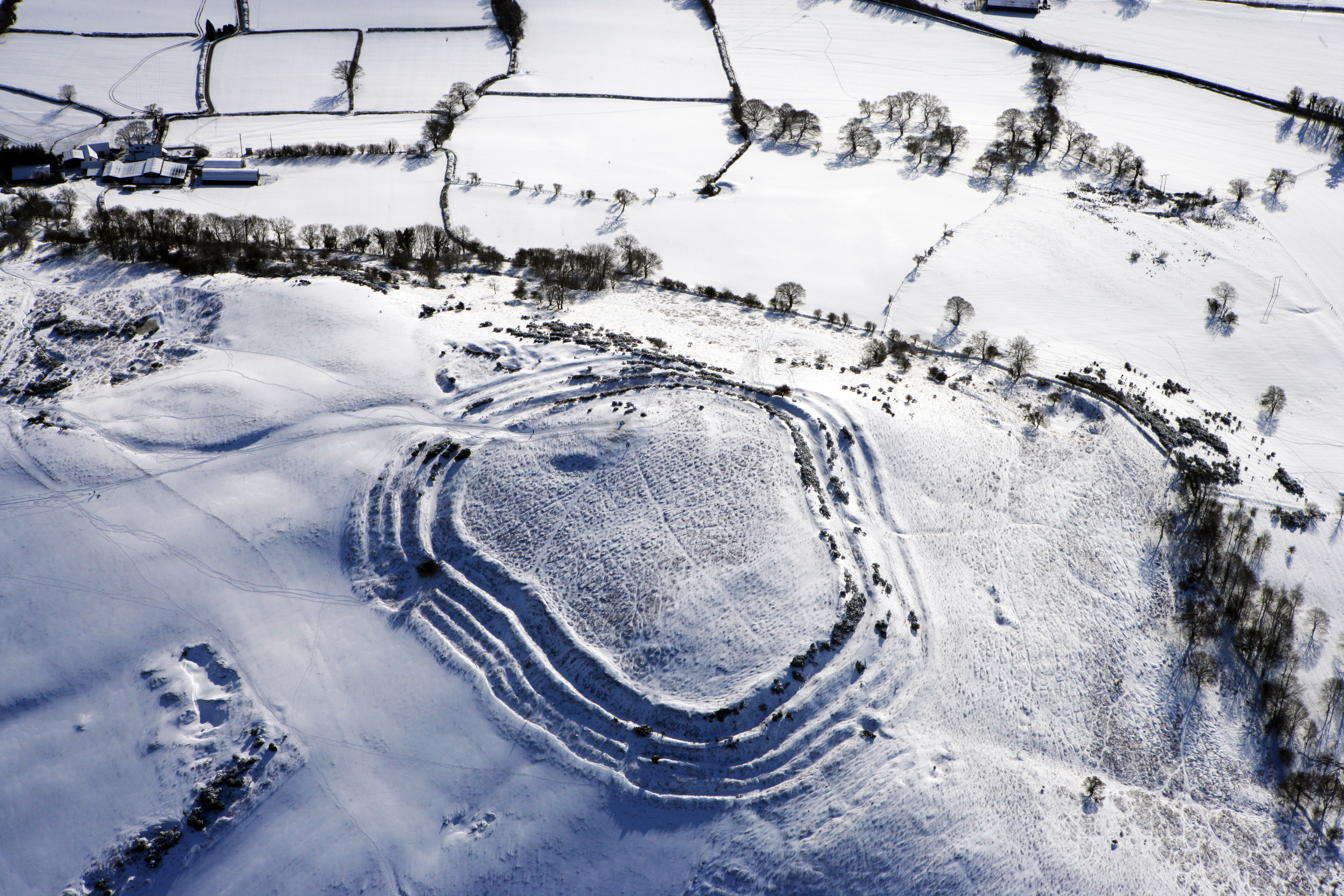
Figure 3: Pen y Crug hillfort near Brecon represents a considerable feat of prehistoric civil engineering. Multiple lines of ramparts were constructed on all sides of the summit. No trickery or illusion was required in the form of a dramatic 'facade' to intimidate visitors; from all approaches the fort appeared bold, artificial, astounding and unbelievable. The leaders who mustered, housed, protected and fed the workforce while they built Pen-y-crug over some years demonstrated, in its completion, considerable power and unassailable social standing (Image: Crown Copyright RCAHMW, AP_2009_0832)
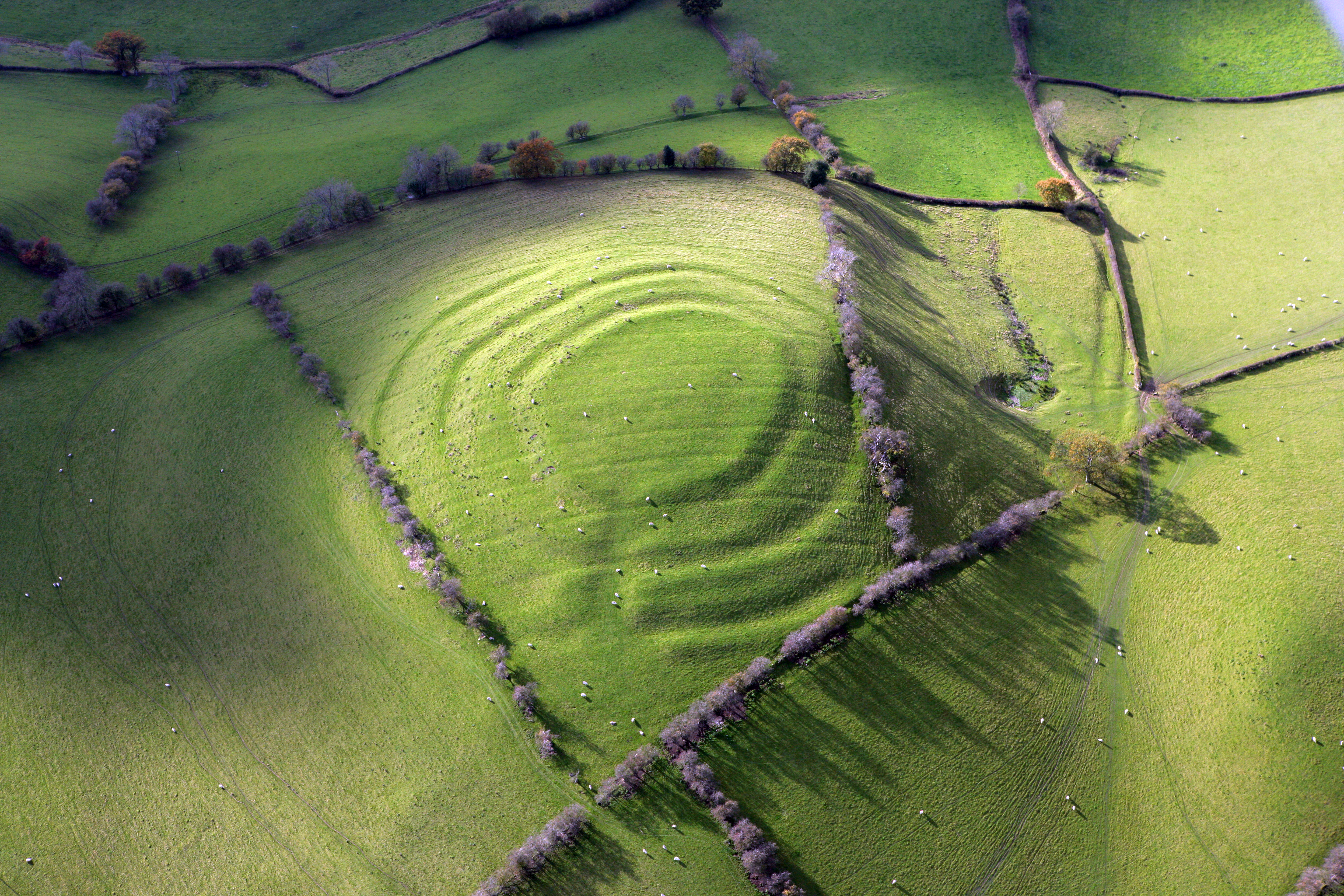
Figure 4: 'Duality' in hillfort defence: Pen y Bannau hillfort, near Strata Florida, Ceredigion. Approaching this fortified outcrop on the ground the multivallate defences seem as steep and impressive as those at Pen-y-crug, Brecon. Did this imply an equally powerful leader and hillfort community? Actually the defences are an illusion to exaggerate the strength of the main gate. The remainder of the outcrop is lightly defended with a low bank, probably a footing for a palisade. Comparable hillforts with strong front doors, and negligible rear defences, are found across Iron Age Britain (Image: T. Driver)
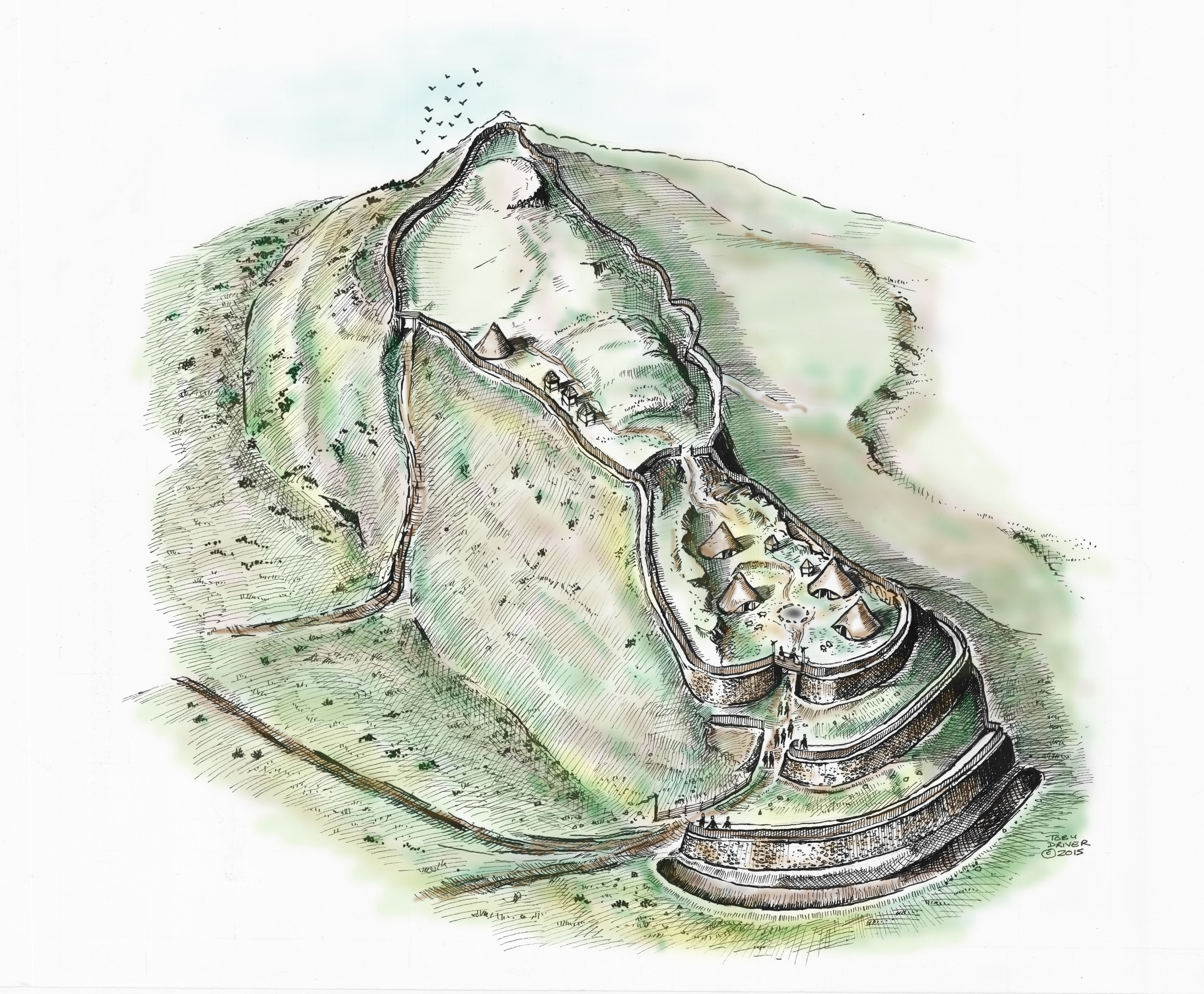
Figure 5: Reconstruction of Pen y Bannau hillfort in the later Iron Age, illustrating the disparity between the apparent strength of the main façade, and the reality of the lightly-defended interior beyond (Image: T. Driver).
Figure 6: Pentre Camp, Llanfair Caereinion. (Image: Crown Copyright RCAHMW, AP_2007_3887)
Figure 7: Looking down from above; Caer Drewyn, Corwen (stone rampart on hill, top centre), is an impressive stone fort on a prominent, defensible hill. Yet, this view from the west shows that its interior was fully on view from below (Image: Crown Copyright RCAHMW DS2008_220_004)
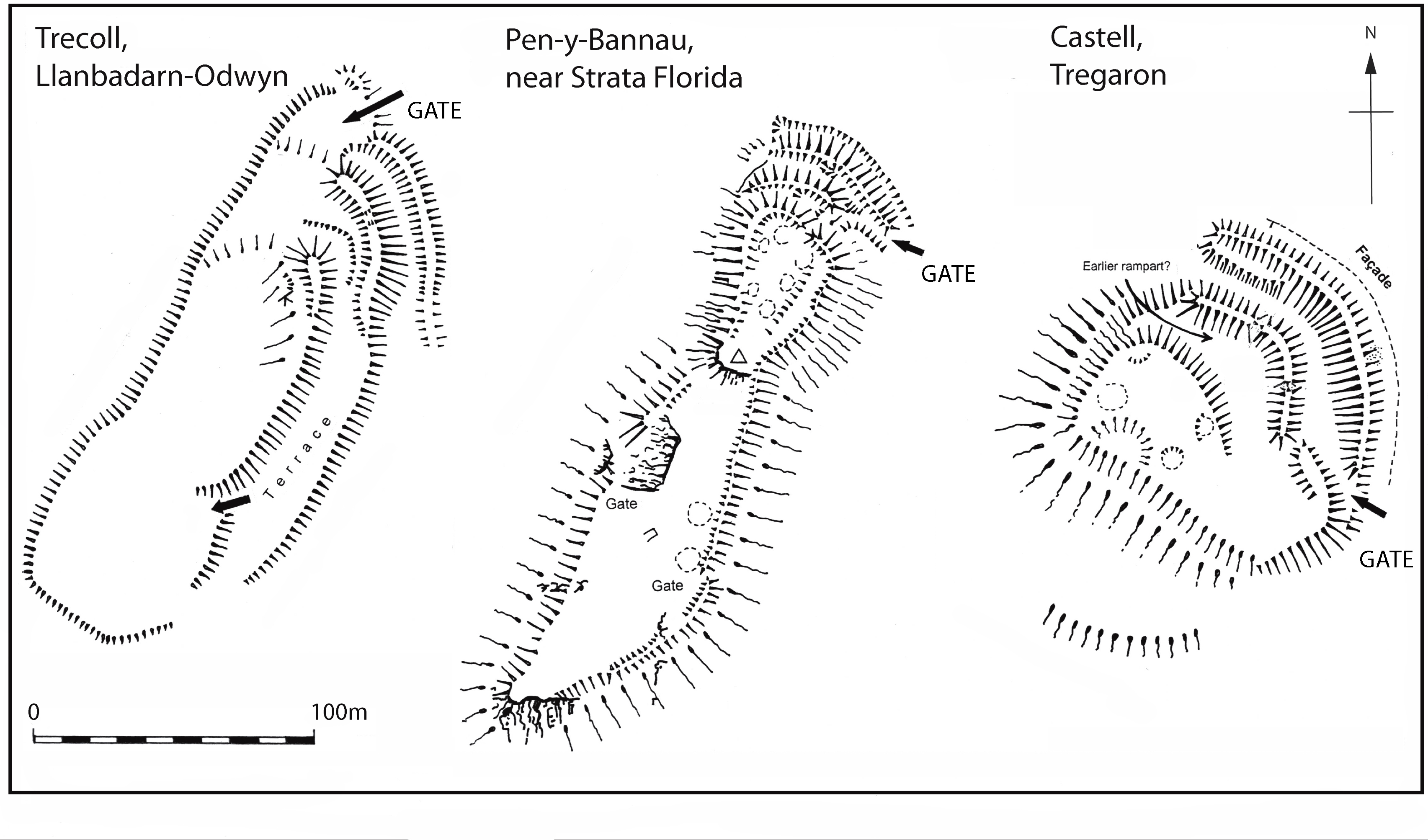
Figure 8: Shared architectural traditions: three hillforts built around Cors Caron/Tregaron Bog in mid-Wales, all sharing north-east facing multivallate entrances with little or no significant defence of the remaining perimeter. The method of building is also similar; all three gateway ramparts are steep-faced and close-set. Crucially, the locations chosen for each fort are very different showing that terrain alone did not constrain or dictate the finished plan of these forts; instead they appear to follow a prevailing regional architectural tradition (Image: T. Driver)
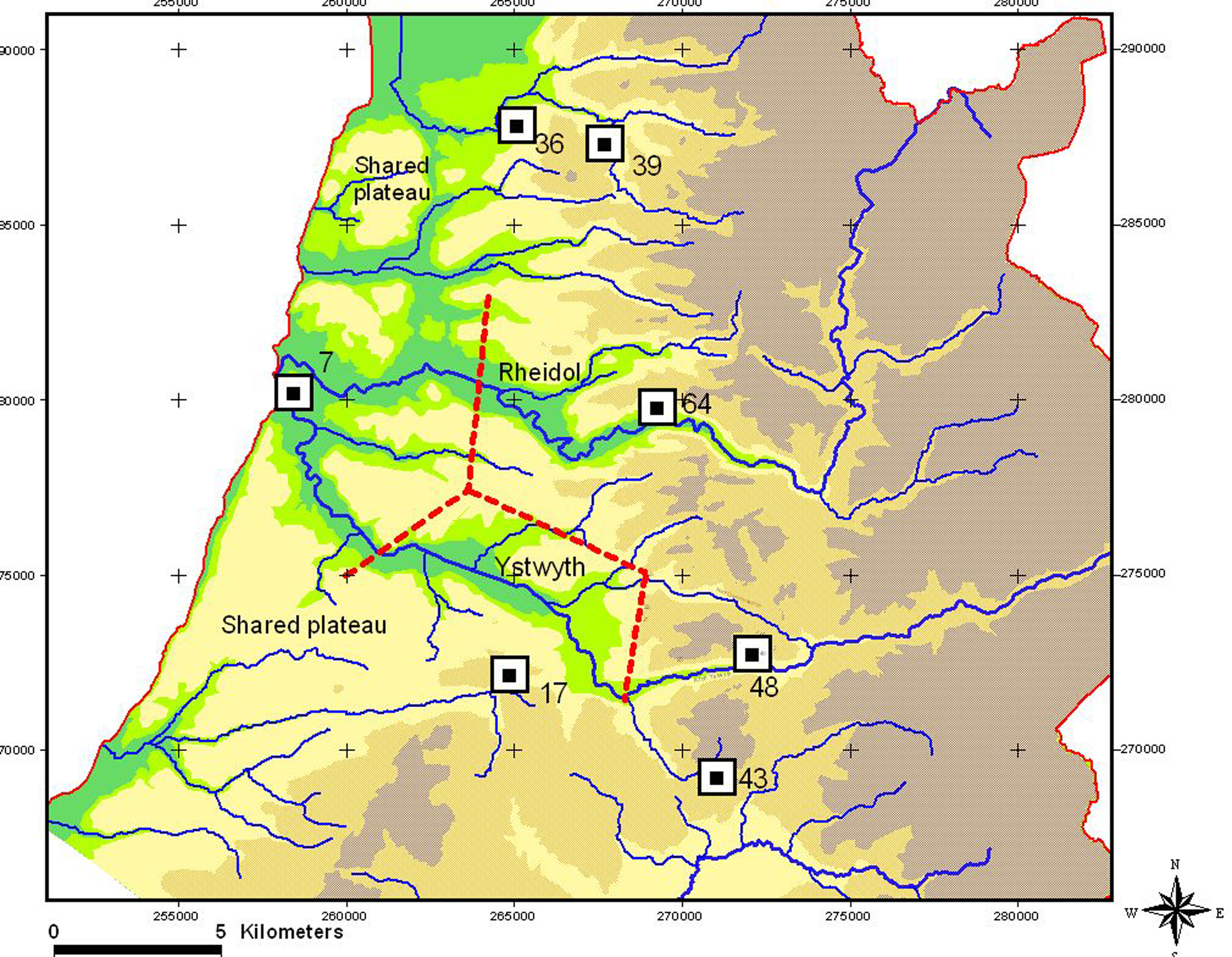
Figure 9: Hillforts sharing the same architectural tradition (the Pen Dinas tradition) in north Ceredigion. Compiled at the end of a long process of architectural identification and study, the final distribution of forts in the landscape has immediate implications for the control of the Iron Age landscape. Three principal hillforts, Pen Dinas Aberystwyth (site 7), Gaer Fawr (site 17) and Tan y Ffordd (site 64), are so similar as to be potentially contemporary. They are evenly spaced occupying (respectively) a coastal inlet at the confluence of the two major regional rivers, an inland hill dominating the Ystwyth and an inland valley side dominating the middle Rheidol. Schematic boundaries drawn between the principal forts suggest lands which may have fallen within the control of each hillfort, equating to a share of the main river valleys and associated hill pasture and woodland. (Driver 2013, fig. 8.12; Crown Copyright RCAHMW. © Crown copyright and database rights [2014] Ordnance Survey [100022206])
Figure 10: Castell Rhyfel, Ceredigion. This un-monumental, simple defended enclosure (centre) crowns a bare, rounded summit removed from neighbouring hillforts at the edge of an expanse of upland moor. The nature of its setting tells us something about its possible role. The valley of the Groes Fawr which it overlooks (valley, above) is marked by standing stones, funerary and field clearance cairns indicative of Bronze Age use as farmland, and as a routeway into the mountains. On closer inspection Castell Rhyfel is not such a simple enclosure; while no house platforms are visible it encloses a rounded summit dominated by a deep spring issuing two streams. It is possible to read the 'fort' as a Later Bronze Age enclosure, perhaps used for transient or seasonal upland meetings rather than for permanent settlement, focused on a spring which may have had special importance (Image: Crown Copyright RCAHMW, AP_2015_0288)
Figure 11: Moel Hiraddug; a view across the Iron Age world. Ascend any high hillfort on a clear day and one is greeted with stunning views across the Welsh countryside, and beyond. The Clwydian Range hillforts command views to the west as far as Snowdon, and to the east and north as far as the Cheshire Plain, Merseyside and the Irish Sea. Hillforts in south Wales look across the Severn Estuary on a clear day to Somerset and Devon. For the modern visitor this is a pleasant view, but to the Iron Age people occupying these forts this must have been not only a source of power and regional control, but a considerable source of enlightenment. In a time before maps, the occupants on Moel Hiraddug already understood the lie of the north Wales coast, the hills to the south, the peninsula of the Wirral and the Mersey estuary. They could readily see neighbouring forts and farms. The 'mental map' of their own world spanned hundreds of miles just from their front door, a benefit of a hilltop fort probably equal in importance to the much vaunted strategic ability to monitor the approach of enemies (Image: Crown Copyright RCAHMW, DS2008_018 _009)
Figure A: The engineering achievement represented by even small and medium-sized hillforts is considerable. This view shows the well-preserved infilled rock-cut ditch at Hen Gaer, Ceredigion, overlooked by a massive 3-4 metre high rampart that was originally stone-faced (Image: T. Driver. CD_2005_621_002)
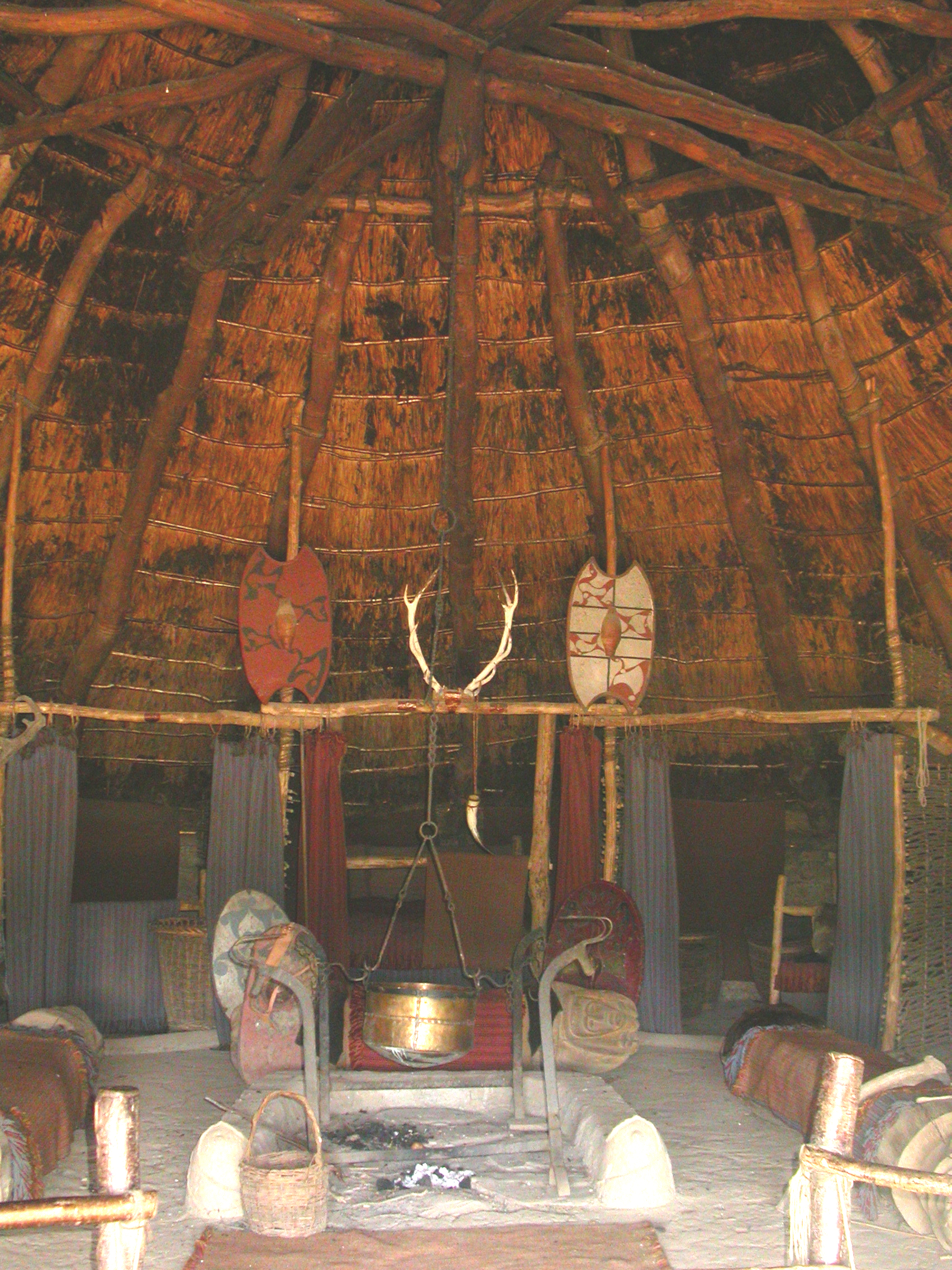
Figure B: Impressive Iron Age roundhouse reconstructions at Castell Henllys have taught us much about the robust and durable nature of these prehistoric homes, which would have provided comfortable year-round accommodation for many years. (Image: Crown Copyright RCAHMW, DS2005_017_025)
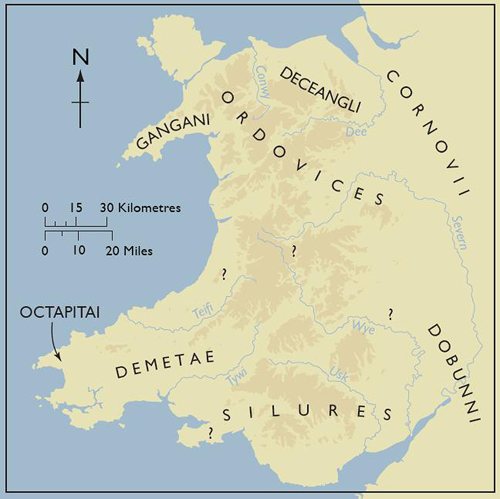
Figure C: Ptolemy's tribes of Wales (chiefly after Webster 1981, fig. 1, with several additions). This new map, produced for Cadw's Defended Enclosures project, includes the minor tribes of the Gangani and the Octapitai who occupied the discrete territories of the far western peninsulas of north and south Wales (Prepared by M. Ritchie and T. Driver. © Cadw, Welsh Government (Image: Crown Copyright))
Internet Archaeology is an open access journal based in the Department of Archaeology, University of York. Except where otherwise noted, content from this work may be used under the terms of the Creative Commons Attribution 3.0 (CC BY) Unported licence, which permits unrestricted use, distribution, and reproduction in any medium, provided that attribution to the author(s), the title of the work, the Internet Archaeology journal and the relevant URL/DOI are given.
Terms and Conditions | Legal Statements | Privacy Policy | Cookies Policy | Citing Internet Archaeology
Internet Archaeology content is preserved for the long term with the Archaeology Data Service (ROR). Help sustain and support open access publication by donating to our Open Access Archaeology Fund.