
Cite this as: O'Keeffe, J.D.J. 2018 'Do I really need to dig it?' — Making Choices in Development-Led Archaeological Excavation in Northern Ireland, Internet Archaeology 49. https://doi.org/10.11141/ia.49.7
In Northern Ireland, any search for archaeological material that involves excavation must, by law, be conducted under and in accordance with a licence issued by the Department for Communities under the provisions of the Historic Monuments and Archaeological Objects (Northern Ireland) Order 1995. This is a statutory control on how excavations are conducted and, through conditions that are normally attached to this permission, a licence is normally issued to a specified individual, to conduct their work at a specific location, at a specified time, and for a specified purpose. In practice, it is the lead archaeologist for a project who is issued with this licence, and works are carried out on their behalf by the excavation team (where the project is of sufficient scale to have a team).
The archaeological licence focuses upon the conduct of the archaeologist that leads the project. However, in Northern Ireland, just as is the case elsewhere across Europe, the context in which most excavations occur has changed in the past 25 years. Licences may be granted for very specific survey projects that include sampling of material from a site, but in most instances licences are granted for the following kinds of works:
As is the case elsewhere, development-led interventions and excavations are the most common form of archaeological work in Northern Ireland, and it is development-led work that forms the main focus of this article. It is important to note that the requirement for the excavation, in the first instance, will normally be determined through the spatial development planning process. So, while there are still some research-driven excavations (most commonly conducted by academic institutions), and investigations as part of conservation work at major historic monuments (usually monuments in State Care, and conducted by government bodies), the vast majority of excavations are now conducted as part of the spatial planning process, and as such they are normally:
These excavations are conducted by archaeologists under the legal requirements, operating in a commercial capacity. One could, perhaps, describe this form of archaeological work as a by-product or service element of the construction industry, one that has in Northern Ireland received substantial public and private funding. It is led by the archaeology being uncovered in the course of development work; while it is informed by earlier research and knowledge about the historic environment in its widest context, it is still a very reactive work activity, dealing with each set of remains as they are encountered.
In Northern Ireland, the requirement for archaeological remains to be considered in the context of spatial planning derives from English Case Law (Hoveringham Gravels Ltd v Secretary of State for the Environment, 1975). However, it was not until the 1990s that development-led, and developer-funded, archaeological excavation became the normal, routine component of site development that it is today. Changes in planning policies in the 1990s, and specifically the adoption of Planning Policy Statement 6: Planning, Archaeology and the Built Heritage (Planning Service 1999), along with a significant upwards swing in the general economy and construction sector in particular, led to a massive increase in archaeological interventions on development sites. In the early 1990s, there were less than 400 development proposals considered vis-à-vis impacts on archaeology each year. In the past 15 years there has been at least 2000 sites considered specifically with regards to archaeology each year (see, for example, O'Keeffe 2008, 5). This has also led to an almost exponential growth in the numbers of excavations. It is estimated that in the period from 2000 until the present time there have been more archaeological excavation projects undertaken in Northern Ireland than in the previous 75 years combined (see, for example, Murray and Logue 2010, xv).
Guidance has been issued recently around how the wider historic environment, including archaeological sites and monuments, are considered in the spatial planning process (Department for Infrastructure 2017). That document outlines, primarily for developers and the public, legislation, policy and processes, including descriptions of how and why some cases will be considered (such as proximity to recorded sites).
All decision-making processes require a point of commencement. For development-led work this may be considered to be when someone decides to build something. As part of the normal planning process, the proposal will be considered against a wide range of policies and considerations, from road safety to urban density, impacts on flora and fauna to land-use designation, and including the historic environment. The triggers for any of these considerations will include local development plans and designations. For archaeological field monuments, it was a major — and ongoing — corpus of research-driven fieldwork that gathered information which is now being used in the planning process. The primary trigger for consideration of archaeology in the context of new development will normally be the proximity of a development site to a feature of interest that has been included in the Northern Ireland Sites and Monuments Record (referred to hereafter as the NISMR).
This is where research-driven fieldwork has had one of its most enduring impacts on development-led work. The NISMR was established in the 1970s, initially to gather all known information about recorded archaeological field monuments (Brannon 2002, 495; Given 1996). Information was gathered from Ordnance Survey maps and documentation from the 1830s onwards, with the sites inspected to categorise their form, character and, where possible, date of construction and historical use. Subsequent programmes of research augmented this record with information gained from aerial photography, documentation in publications especially from the nineteenth century, and from reports of new sites from local communities and, in particular, farmers and agricultural inspectors. The NISMR was subsumed as a discrete element of a larger archive, the Monuments and Buildings Record (now the National Monuments and Buildings Record), in the 1990s, which also includes information about industrial heritage sites, parks, gardens and demesnes of special historical interest, and defence heritage sites. While the NISMR was initially a paper map-based resource (with accompanying files of written and drawn information), over the past 20 years much of this spatial data has been computerised and shared with other local and central government bodies concerned with spatial development and land-use change.
Northern Ireland is not a large territory, comprising some 1.4 million hectares, with a population of some 1.8 million people. In terms of its archaeology, the earliest remains identified to date are from the Mesolithic period (Mallory and McNeill 1991, 11), and so our archaeological record extends back a mere 10,000 years. However, it has some 16,500 known or suspected sites of archaeological interest, ranging from find-spots of artefacts through to complete castle complexes and post-medieval towns, as well as some 17,000 sites of industrial heritage interest and hundreds of designed estate landscapes, battle sites and shipwrecks.
Development-led works have, however, revealed large numbers of sub-surface sites that had no upstanding features and which had not been identified from previous surveys. These are often features which are only identified once the process of site development works begin. Anecdotally, development-led interventions have revealed somewhere in the order of one new site of archaeological interest for every 3 to 5 hectares of land, while the whole landscape is criss-crossed by field boundaries and routeways that are many hundreds if not thousands of years old. As one may appreciate, if the estimate of the numbers of previously-unrecorded sites was in line with the anecdotes of discovery to date, then the landscape of Northern Ireland is very rich in archaeological remains indeed.
The kinds of new sites that are identified tend to be prehistoric remains, especially Neolithic and Bronze Age settlement and funerary remains, along with some Early Medieval remains, and appear to be very much part of the ordinary, everyday lives of people in the past rather than the larger monumental structures that have survived as upstanding features in the landscape. Brief descriptions of the sites investigated are recorded on-line at http://www.excavations.ie. Our growing awareness of how much archaeological material still survives and which has not yet been recorded means, in practice, that where significant areas of previously-undeveloped land is used for new building, there is a great likelihood that choices will need to be made about the protection or excavations of sites that were otherwise unknown.
In working practice there has been something of a nuanced approach to dealing with certain kinds of remains depending on where they are located. In urban areas, especially in the cores of historic towns, it is usually the case that where development is permitted it will require the formation of new basements or subfloors, essentially stripping out whatever underlying archaeological remains survive. While the archaeology of urban sites in Northern Ireland is usually not very deep, there is a growing appreciation that many of our cities and towns have earlier antecedents in excess of 400 years old. Building requirements will normally affect at least 1m below the present ground surface, and the underlying archaeology is seldom much deeper than this.
For peri-urban areas, any upstanding monuments are likely to be retained as features of new development, sometimes as amenity space. In rural areas, where there is greater scope for amending building designs and locations, it is usually the case that known sites — be they upstanding monuments or below-ground remains — will be avoided. These are not hard-and-fast rules, but they do reflect a common approach amongst archaeologists at the present time. One must wonder, however, if there will be a need for special reserves of archaeological material in some towns, achieved through the sustainable reuse of existing buildings (i.e. if the existing building can be retained, then the underlying deposits may also survive). In rural areas, it is larger projects such as roads infrastructure that normally result in excavations being necessary. For such larger projects, it is virtually impossible to avoid the need for some excavations, even if all previously-known remains have been mapped and excluded.
Preservation in situ is provided for in policy in Northern Ireland, but has not been widely tested in practice in urban contexts. Individual monuments may be preserved, but archaeological layers exposed in the course of development work are less likely to be preserved in situ in a major site, especially as a range of other investment decisions relating to the development have already been made. As noted above, in urban contexts in particular, the combination of the kinds of development and the availability of space, alongside building regulation controls, means that preservation is seldom achievable unless it is accounted for in early design stages of a project. The choices tend to be focused on a simple financial consideration: what costs less, removal of the remains or redesign?
The use of computerised data now makes it a lot easier to establish when a proposal is going to be considered vis-à-vis impacts on archaeology and ultimately, in most cases, whether or not an archaeological excavation is going to be required. At this point a series of professionally-informed and evidence-based judgements are needed to advise the process, as in many cases it is the development proposal that will spark discussion about what might be encountered in excavating the site — what might be found and also what might be lost. This has been informed largely by the working practice of a generation of archaeologists for whom dealing with the development process is a normal activity, rather than earlier times of research or rescue interventions.
Formulating advice for the decision-making process is usually part of an iterative process, assembling facts and understanding about a site or monument, ascribing values to aspects of these, and justifying the advice in terms of policy and process. A simplified flow-chart of consideration is shown in Figure 1, with a simplified flow-chart of evaluation in Figure 2. These are used here as a tool to articulate some of the thought processes involved. One must emphasise just how important the NISMR is as a resource to inform the management of archaeological field monuments and guiding archaeological excavation. It needs to be augmented by sound working knowledge of what the outcomes were of previous interventions, if the outcome is likely to be the same or not, and how that might affect the next choice. The NISMR remains a living record, it is being added to all the time, and is the primary source of evidence that is used in all management decisions about any archaeological site or field monument. There is also an onus on archaeologists to refresh their knowledge-base, making use of the new information that is brought to the NISMR.
There are, of course, some limitations to the NISMR; its focus primarily on previously-mapped sites means that sometimes the spaces in between are ignored. It is becoming increasingly apparent that the spaces between the known sites are not empty, but that that we have not yet examined them in sufficient detail. Previously-unrecorded sites are identified every year, revealed in the processes of their destruction through development and through excavation.
However, it should be noted again that neither archaeologists nor research agendas lead the process. As a sector, archaeologists have limited control, for the most part, about a series of decisions resulting in the major physical change of a site or place. In many cases those decisions have been made for a range of financial, environmental or societal reasons, a consequence of which is an impact on archaeological remains. As a sector, archaeologists can input to the laws, policies and plans that affect sites, but it is recognised that these are primarily focused on development and land-use change. The planning process is not in itself a research tool, but the results of the process provides significant, and growing, databanks of archaeological material (Hull 2011).
In making choices about whether or not a site will require to be excavated, and also in the course of the excavation itself, it is not possible to have a simple binary response of 'yes' or 'no'. The process is more nuanced, since it will depend upon knowledge of the remains in question, the impacts that would otherwise happen to those remains, and the relative importance ascribed to them. Ironically, a set of remains may be excavated because they are very rare and important, or because they are more common, fragmentary and vulnerable at a site. In both instances, the imperative to excavate is their impending destruction. There are, however, key 'checkpoints' in the process, required in order that a statutory obligation is met and a decision to provide certainty in the development process is achieved. In those instances the questions can normally only have a yes/no response. It is possible that a computerised system could be invented to take care of this process, but it would require constant feeding — just as a human being does — to receive and process new information about significance, discovery and impacts.
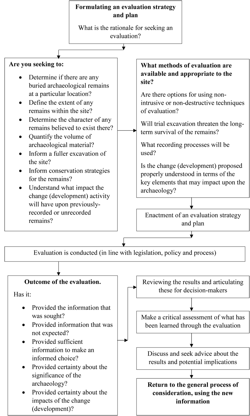
A process of evaluation can assist in determining the extent of an excavation requirement. If, for example, the imperative is to record remains in advance of their destruction, one may ask 'How much?' 'Does the totality of a site need to be recorded, or is it sufficient to record enough information to reveal the nature, extent, character, composition, origin and evolution of a specific site?' 'If only samples are to be taken, what should happen to the remainder if it is not preserved in situ?'
However, where a planning requirement seeks to ensure remains that would otherwise be destroyed will be recorded, then it is frequently assumed that 'all' of the remains are to be 'fully' recorded. Through the process of monitoring compliance with planning requirements and especially licence requirements, discussions continue throughout a project between the developers, the archaeologists 'on the ground', and the regulators to reach pragmatic agreement about the treatment of remains, usually on a case-by-case basis, utilising the professional judgement of all concerned.
It is understood that, if the development site is what is subject to the requirement for an excavation, then works will normally be tightly confined to the development area. This is not to say that the archaeological remains encountered are wholly contained within such a development footprint, but it does mean that one cannot 'chase' remains outside of the development area without good reason and, in particular, the agreement of the project sponsors. In reality, any remains that extend outside of a development area may either be preserved pending any future decision about that land or, in some cases, may become the focus of a research-led intervention at a later date.
This can, on occasion, lead to issues about how one can interpret the significance of a discovery if it is restricted only to a small portion or area of a larger site. If research frameworks and projects are developed, then it is perhaps sites such as these that require the most urgent attention, recognising that infrastructure works in particular tend to take a course through the landscape that relates primarily to the new works project.
It should not be forgotten, however, that development-led works result in some spectacular discoveries and, even when processes of site investigation, evaluation and review have been completed, the final outcome can be very different than what was expected at the beginning. For example, the investigation in 2002 of a site at Corrstown near Portrush, on the north coast of Northern Ireland, led to the discovery of an extensive and previously-unrecognised form of archaeological site that demands a re-think of our understanding of the Bronze Age in this part of Ireland and perhaps further afield. A shadowy feature identified on an aerial photograph triggered a consultation about a new housing development. On first inspection of the site, the present author identified large quantities of struck flint, but no upstanding features. A geophysical survey was commissioned and trial trenching initiated, both of which identified further archaeological material and some sub-surface features, but none of such extent as to indicate that there were more remains other than perhaps the ploughed-down remains of a prehistoric settlement area.
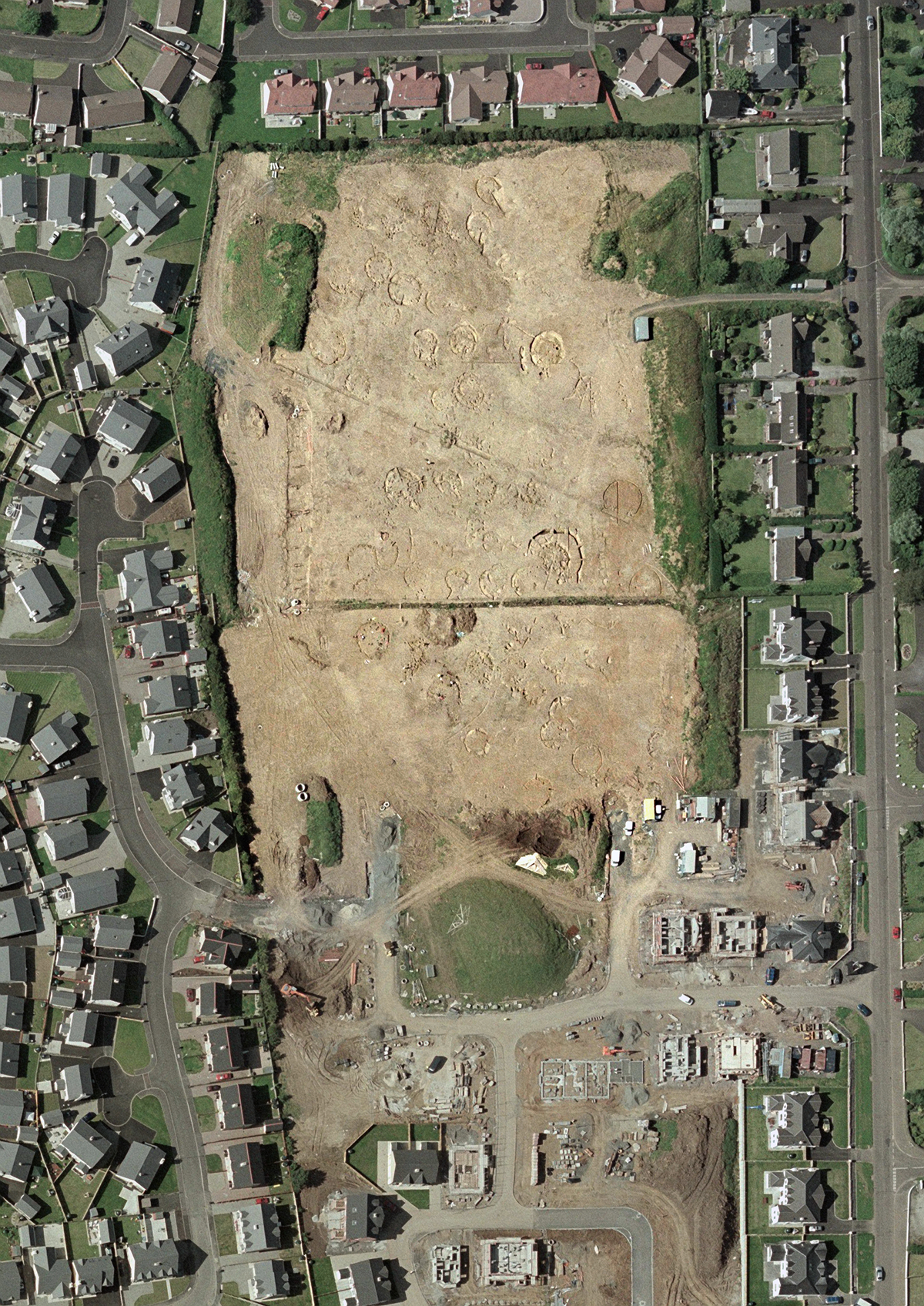
In the event, a nucleated settlement of at least 74 round houses, of which perhaps 50 at any one time were in use, was identified in an area of some 22,200 square metres (Ginn and Rathbone 2012; Conway 2010, 9). This was a Bronze Age village, of a type not recognised before. However, on excavation, parallels could be drawn immediately with another site on the east coast of County Antrim which was also revealed in the course of new development, at Ballyprior Beg (Suddaby 2003). In the example at Ballyprior Beg, a roundhouse, with walls some 2m thick and in part upstanding but buried under later deposits of soil, was excavated, along with part of a second structure. On revisiting the site following the discoveries at Portrush, the present author noted that it is quite likely that this also forms part of another village of comparable date and situation. These were discoveries that would almost certainly not have happened were it not for the development activity, and the involvement of archaeologists in that activity. In the case of the excavation at Corrstown, the primary sponsor of the project — the Kennedy Group — was highly commended in 2004 in the British Archaeological Awards developer-funded archaeology category.
Attention is drawn to these two sites as good examples of how the choices made, to permit the excavation of a site as a result of some other investment decision, results in major discovery. These are not unique in Northern Ireland. The two sites also provide good examples of how the contexts of discovery fundamentally impact upon how one may interpret each site at the time of discovery. The Ballyprior Beg example was unearthed in the path of a new electricity cable. The working width of the project was only 20m wide (Suddaby 2010, 7). Within this working width the complete floor plan of a roundhouse was excavated. The working width of the cable route defined the extent of the excavation. The edge of a second structure, most likely another roundhouse, was also noted, but no other features other than those within the working width of the project were investigated. Thus, in this instance, the site could be recorded as a settlement site, but the wider extent of the site was not known. While the excavation yielded much information about the structural form of the house and some insights into the lives of its inhabitants, there was limited scope to say much more about the contemporary settlement landscape of the structure when it was in use.
Corrstown, however, was an extensive open area excavation. Its boundaries were also constrained by the extent of the development that caused the excavation to happen, but in this instance the area involved was much broader. Had either site been under alternative development proposals, e.g. had the cable route been proposed at Corrstown and a housing development at Ballyprior Beg, then the outcome — and understanding — of the remains could have been quite different. The site at Corrstown has been excavated and the features have now been built over. The site at Ballyprior Beg, however, continues as an agricultural field, and a site of significant potential for future research.
Clearly there has been extensive discovery as a result of development-led work; the examples cited here are only two out of hundreds of interventions that have revealed extensive and 'new' sites. Unfortunately, however, there have been issues with the wider dissemination of information that arises from the excavations. In Northern Ireland we are fortunate that the licence requirements oblige the archaeologist to submit a report of their works for inclusion in the NISMR. This means, at least, that the data is being gathered and, through the NISMR, is made publicly accessible. The processes of synthesising the results from multiple excavations have been slower, and putting the new discoveries in a wider context has not kept pace with the rate of discovery. Ginn's work on Bronze Age settlement structure of the middle and late Bronze Age in Ireland is an excellent example of how, drawing together the results of historical excavations and the accounts of more recent development-led interventions can lead to a reappraisal of our understanding of society from that time (Ginn 2016). Similarly, the Early Medieval Archaeology Project (EMAP), a collaborative project between the academic and commercial sectors of archaeology on the island of Ireland, made specific use of the wealth of new information arising from development-led projects to conduct a fundamental reappraisal of what is known, understood or suggested about life in the first millennium AD in Ireland. These thematic approaches have taken the fieldwork to drive forward research which, in turn, is now feeding back into our knowledge and understanding of these and similar sites. It will thus inform future study of, and decisions about, excavations at development sites that may yield these kinds of remains in the future.
The application of such new insights has also helped provide certainty for developers about the potential archaeological impacts, and costs, of development. For example, from the results of excavations within the historic cores of a number of cities and towns in Northern Ireland, it was becoming apparent that (a) the scale of new development from 1999 was starting to erode whatever archaeological deposits survived there, and (b) many sites were yielding remains from at least the seventeenth century AD if not before. This posed questions at many levels; were the archaeological remains the traces of the earlier antecedents to the settlements as we see them today, or were they coincidental deposits that happened to be uncovered there? How did these settlements evolve, and are they really just the product of seventeenth-century Plantation and eighteenth/nineteenth century industrialisation? Belfast was taken as a case-study (O'Keeffe 2006, 1-7), and as part of preparation for choices in the context of new spatial development plans, all of the identified settlements in Northern Ireland have now been examined to establish if they have, or are likely to contain, buried elements of the settlements that may be traced through archaeological examination. This project has resulted in a Gazetteer of Historic Nucleated/Urban Settlement for Northern Ireland, now part of the NISMR, which can be used by developers, archaeologists and members of the general public to research and address the archaeology of over 300 settlements that continue today as cities, towns and villages.
The effort has been worth it, but the job is not yet complete. Arguably the job will not be completed, since archaeological investigation will result in further discovery, and re-evaluation of what has been found will lead to new insights and new directions of thought. This is one of the most attractive, if sometimes a most frustrating aspect of archaeological research: in looking for answers we keep coming up with new questions!
Looking to the future, there is clearly a need for greater civic involvement in the work of archaeologists, from participation in the excavations to the analysis of results, from exploring in new ways our rich archaeological heritage through to advocacy of why archaeology is important. The growing number of interventions means that we may need to think about widening the field for those who take part. The technical processes of excavation and analysis cannot happen without the thoughtful processes of developing ideas and knowledge. Perhaps we need to consider preparing the way for professional career paths that are not just through universities in the context of development-led investigations, but it will be a challenge to ensure that the sound academic foundations are still there for conducting the work.
There is the ongoing need to greater engagement within the sector, especially in the context of continued professional development and lifelong learning for archaeologists. In particular, there is, I feel, a growing need for periodic review, gathering together and debating what we understand about the past that makes use of newly-revealed information, just as Ginn (2016) and others have demonstrated.
Is question-driven fieldwork vital or not?
The fieldwork now underway in development-led excavation in Northern Ireland is a result of research designed to record, quantify and interpret the resource of archaeological field monuments, and subsequently to enable evidence-based advice to be given and decisions to be made which at least considered the impact of development and land-use change upon the historic environment. In that context, the research intentions of the 1970s onwards to compile the NISMR is driving the present fieldwork activity; such fieldwork today is unlikely to ever have been possible without the pioneering research of that time.
How do we identify research frameworks in order to make the necessary choices?
As the fieldwork was driven by research, perhaps now research frameworks need to be driven by the ongoing fieldwork. We have accumulated major collections of data through development-led excavations and interventions, with huge funding from the public and private sector. It is difficult to put a precise figure upon how much money has been spent directly upon excavation and how much has been spent servicing the excavations, as very many projects were undertaken on behalf of private developers. However, there must now have been many tens, if not some hundreds of million pounds invested in this work in the past 20 years. In order for fieldwork to start driving research, archaeologists need to make progress on the conversion of the data gained through development-led interventions into knowledge that will, in its turn, influence future choices in archaeology. This must, arguably, be a process of analysis that incorporates both specific sites and the data overall, synthesising the results to see what insight the various excavations have provided. Many of the development-led works have resulted in fairly small-scale archaeology projects that, individually, may seem unremarkable. Taken collectively, however, such interventions may in fact be providing much more new information that has been appreciated to date. It is the pattern of new spatial development that will continue to provide the primary impetus to new excavations here. With that in mind we need to ask questions about what the interventions will provide and how best to acquire that new information.
What questions need to be answered and subsequently what methods / field strategies do they require?
The answer to this question will depend, in many respects, upon the question that was asked immediately before. Understanding what has now been revealed through development-led work will inform any future choices. For example, with the exception of certain infrastructure projects, most interventions in Northern Ireland have happened within or around modern settlements. Sometimes these projects have focused on the historic cores of our cities, towns and villages. However, as the urban footprints expand, the projects have revealed remains quite separate in time from the settlements themselves, but has led to a geographical imbalance in research about the historic environment in particular areas. For example, some of the best-preserved Bronze Age monuments in Northern Ireland are located in farmland and uplands in County Tyrone, while County Fermanagh has one of the highest percentages of upstanding monuments. Neither county has seen the scale of new development encountered elsewhere in Northern Ireland, and so there has been much less investigation of sites, or recovery of previously-buried or unrecorded sites that has happened elsewhere.
How do we develop criteria and standards for assessing the significance of the archaeological sites?
In Northern Ireland there are already well-established non-statutory criteria for the evaluation of sites, contained in Annex B of Planning Policy Statement 6: Planning, Archaeology and the Built Heritage (Planning Service 1999). However, our future use and development of such criteria will be informed by what has gone before; new discoveries require the re-evaluation of the criteria and the sites themselves, which can once again only be achieved through better understanding of what development-led works have uncovered.
Which political/economical/social realities do we take into account in the creation of our selection criteria?
We can be certain that these realities have, and will continue to have, a direct impact upon our selection criteria and the work of archaeologists in general. Within this, economic considerations will, inevitably, be one of the most significant considerations. In many respects the debate about whether or not archaeology is a valid consideration in the context of development and land-use change has moved on. There have been changes already in the context of spatial planning policies, with a move to greater ownership by local councils of the policies and proposals contained in local development plans. There remain overarching policy documents for all of Northern Ireland, such as the Strategic Planning Policy Statement and the Regional Development Strategy 2035, and it is important that archaeologists in general know that these have a direct effect on how choices are made that will result in excavations happening. Archaeologists may advise the process, but for the most part they continue to be advisors to a decision-making process, and have a key role in dealing with the outcomes of those decisions when sites require investigation.
Major monuments — either those that are the most substantial, best preserved, or rarest — will seldom be the focus of complete destruction through development and archaeological excavation. These are tangible sites, where the financial implications (especially of the most substantial sites) will feature prominently in the minds of the project initiators and sponsors, and in many instances these will be the most familiar landmarks for local communities who value the sites. This has an effect upon the skill sets and knowledge required to investigate such sites should the need arise, since the technical and academic processes involved in dealing with the most substantial and complex sites will not be required on many other excavations. Developing and retaining skill sets is an issue for the profession at large, as is continued academic and professional development. The new discoveries are changing our understanding of the past, of the monuments and of societies, technology and beliefs. There is an ongoing need for replenishing our knowledge, continued professional and academic development, to enable informed choices.
What is perhaps a more pressing issue is the appreciation of just how many sites have not yet been found, or will only be found, in the process of new development. A major discovery could lie concealed in the path of a new motorway, school, hospital or housing development. Ensuring a sound evidence base, either through augmentation of existing records or new surveys to evaluate such sites (for example, through Environmental or Heritage Impact Assessments), helps all of those concerned with what happens to any given place that is being proposed for development, be they developers, archaeologists, members of the general public or key decision-makers.
Dealing with archaeological remains has become 'normalised' in the context of development and land-use change in Northern Ireland. That is not to say that it is fixed and everlasting; one cannot say what the future will hold in the decades or centuries to come. As archaeologists, we are dealing with a very long view. How we make our choices today will determine whether or not there are archaeological sites from our past that will survive for future generations to discover and to make their choices. Balancing the needs, expectations and aspirations of society today with the conservation of the remains of societies from the past will always be a challenge. From such a challenge there is great opportunity, and good work already being done.
Do I need to dig it? Perhaps that question has moved on in the context of development-led excavation. After all, if the site would otherwise be destroyed, then the answer is most likely to be 'Yes', since the laws, policies and practices currently in operation require that outcome. How the site is excavated, who is involved and how does society at large benefit from the excavation will require the sharing of the experience and sharing of the results. At the present time there is an initiative underway in Northern Ireland called 'The Way Forward for Archaeology', led by the Historic Environment Division of the Department for Communities. This initiative is intended to move the discussion and practice forward, with local task groups now being formed around:
The task groups are composed of representatives from the Voluntary/Community, Commercial, Academic, Professional Bodies and Government sectors. It is anticipated that these groups will work over the next year or so, with the outcome of this work likely to influence how choices are made for many years to come. This work, alongside major changes to the structures of government in Northern Ireland over the past three years or so has great potential to help broaden access to archaeology and heritage across society.
It is likely, however, that the question 'Do I need to dig it?' will continue to be asked in a much broader context for archaeological research, not just for development-led work. From a research perspective it is perhaps one of the most important questions that can be asked, since it should be asked throughout the process. If the site is not going to be otherwise destroyed, or if it can be preserved for the future, then perhaps the only reason for excavating it at this time is for the purposes of research and public exposition. It remains a necessary question, and one that archaeologists should not shy away from.
Internet Archaeology is an open access journal based in the Department of Archaeology, University of York. Except where otherwise noted, content from this work may be used under the terms of the Creative Commons Attribution 3.0 (CC BY) Unported licence, which permits unrestricted use, distribution, and reproduction in any medium, provided that attribution to the author(s), the title of the work, the Internet Archaeology journal and the relevant URL/DOI are given.
Terms and Conditions | Legal Statements | Privacy Policy | Cookies Policy | Citing Internet Archaeology
Internet Archaeology content is preserved for the long term with the Archaeology Data Service (ROR). Help sustain and support open access publication by donating to our Open Access Archaeology Fund.