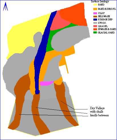
Fig. 2.4 Surface geology
The natural subsoil and geology of the site varied dramatically from area to area ranging from pure sand along the northern limit of the settlement through sand and gravel, gravel, frost-shattered chalk to solid chalk outcrops in the south-eastern part of the site (Fig 2.4). In some areas the chalk bedrock had been so badly damaged and truncated by ploughing that only the bases of the archaeological features survived. Although c.75% of the areas examined were subject to active truncation as a consequence of plough damage, aeolian sand deposits and hill-wash had artificially raised the ground surface such that in some areas, particularly along the margins of the relict stream channel, well-preserved buried soils and associated features survived relatively intact. Feature identification and definition was particularly difficult in these areas; however, the examination of the associated surfaces has provided a vitally important data-set for examining the nature of the settlement between the structures that naturally tend to be the focus of attention. The detailed soil thin-section programme (4.4) undertaken has provided important evidence on soils development and land-use from an environment where both pollen (4.7) or land snails (4.5) are both poorly preserved (3.8 Environmental Data, 4.4 Assessment of Soils, 4.5 Land Snails Assessment, 4.7 Pollen).
Fig. 2.4 Surface geology
Although it had been suggested that the site offered little potential for the recovery of environmental data, experimental work undertaken with an Earthwatch team in 1988 demonstrated the remarkably good survival of extensive carbonized seed assemblages and charcoals which offered an unprecedented potential for analysis from a site of this period. A single feature, a timber-lined spring-pool or well, remained waterlogged, the surviving timbers providing a single absolute date late in the life of the settlement from the autumn of AD 724. Other organic material was limited to mosses and evidence which demonstrated that the well and spring into which it was set remained clean until it filled in naturally. In addition to the abundant plant macro-fossil evidence (4.1), the increasing environmental detail derived from the soil micro-morphology and phosphate studies (4.4) are giving an unsurpassed picture of activity across the site (3.8 Environmental Data, 4.1 Plant Macrofossils, 4.2 Charcoal Assessment, 4.4 Assessment of Soils).
Large open rural settlements, usually having thin stratigraphy, do not benefit from the presence of long intact stratigraphic chains; individual features however, generally survive intact even though some truncation by ploughing has frequently occurred. The level of residuality is consequently far lower than one might expect in a deeply stratified site. There is a tendency to believe that the plough damage on a site such as West Heslerton is such that most of the stratigraphic component has been lost; in reality, the stratigraphic loss is less severe than we might believe. Indeed, direct links between different stratigraphic groups were probably rare even before plough damage. Furthermore, the medieval headland, combined with colluvial deposits, have ensured the survival of stratigraphic sequences that span the entire history of the site. This was particularly the case in the dry valley areas examined in 1995, perhaps on account of the extensive reshaping of the valley that had occurred during the Roman period; as a consequence areas of relict soil survived beneath hill-wash as did an extensive series of worn pebble surfaces, mostly related to Late Roman and earlier activity. The full stratigraphic sequence surviving in the enclosure ditch sequence will form the backbone of the detailed assemblage building that will be a feature of any analytical work. We are fortunate in that a major burning event took place at the end of the life of the settlement generating vast quantities of ash, together with burnt and decayed daub deposits over more than 1ha. of the southern third of the settlement (3.2 Methodology).
Tremendous variations in the artefact and ecofact densities from one part of the settlement to another reflect disposal patterns and settlement management quite unlike those anticipated.
The variation in the subsoils was matched by a similar and related variation in site layout and function. As each area was exposed the nature of the site changed so radically that it might almost be seen as a different site altogether. The excavation methodologies had to be constantly refined in response to the changing nature of the subsoil and the type, nature and density of the deposits. The variable nature of the subsoils and the derived archaeological deposits had an adverse effect upon the preservation and fragmentation of both the artefacts and ecofacts, in particular the animal bone; a situation exacerbated by the use of heavy plant during stripping which, particularly in the sandy areas, increased the level of new fragmentation, principally in the faunal material.
A quite unanticipated but significant feature of the site was the presence of a medieval field headland running from north to south across the western side of the settlement, which preserved a number of important furnaces and similar features and ensured, in some areas, far greater stratigraphic survival than had been anticipated. This headland extended to the south where it may have contributed to the enhanced soil profile in the dry valley where more than 3m of stratified deposits remain (3.2 Methodology).
© Internet Archaeology
URL: http://intarch.ac.uk/journal/issue5/westhes/2-5.htm
Last updated: Tue Dec 15 1998