Cite this as: Kecheva, N. 2018 Archaeоlogical Map of Bulgaria – Transport and Pipeline Infrastructure Projects, Internet Archaeology 51. https://doi.org/10.11141/ia.51.2
Development-led archaeology in Europe is influenced by the Valetta Treaty (European Convention on the Protection of the Archaeological Heritage (Revised). Valletta, 16.I.1992. European Treaty Series – No. 143 1992), ratified in Bulgaria in 1993 (Европейска конвенция за опазване на археологическото наследство (нова редакция). Издадена от Министерството на културата. Обнародвана в ДВ. бр. 70 от 10 Август 2004 г. 2004). Lack of precision in some aspects of the treaty allows for variation in development-led archaeology in different countries. The Bulgarian case, based on Bulgarian legislation, includes a clear workflow with a centralised structure controlling the quality of all legal archaeological fieldwork activities, permissions, data gathering and archiving.
AIS AKB is an archaeological information system of 'sites and monuments' type at a national level (Нехризов 2014). It contains information about archaeological sites from the Palaeolithic period to the Renaissance from across the whole country. It is regulated by a Decree from 2011 (Наредба № Н-2 от 6 април 2011 г. за създаване, поддържане и предоставяне на информацията от автоматизирана информационна система 'Археологическа карта на България' (в сила от 19.04.2011 г.) 2017) issued by the Bulgarian Ministry of Culture. Its creation, development and maintenance are carried out by the National Archaeological Institute with Museum at the Bulgarian Academy of Sciences (NAIM-BAS). Regional administrators at lower levels and national administrators at higher levels are responsible for checking the quality of the users' input data. Reporting newly registered and excavated sites each year in AIS AKB is a necessary part of the annual archaeological reporting, closely related to issuing permissions for archaeological fieldwork for the following year. Data and information from AIS AKB are used in different fields: for the needs of state and municipal agencies, pure scientific research, Environmental Impact Assessment and Strategic Environmental Assessment Reports.
Since the Bulgarian government started receiving financing from European programmes, a lot of transport and pipeline infrastructure constructions and both large and small scale development-led archaeological projects emerged. After 2011, the principle of the 'polluter pays' resulted in a structured project workflow in accordance with Bulgarian legislation being introduced – the Cultural Heritage Act from 2009 (Закон за културното наследство (в сила от 10.04.2009 г., посл. доп. ДВ. бр. 74 от 20 септември 2016 г.) 2017) and the Archaeological Fieldwork Decree from 2011 (Наредба № Н-00-0001 от 14 февруари 2011 г. за извършване на теренни археологически проучвания (в сила от 01.03.2011 г., посл. изм. ДВ. бр. 95 от 29 ноември 2016 г.) 2017), both issued by the Bulgarian Ministry of Culture. NAIM-BAS, being the national centre and coordinator for all fieldwork, controlling them both scientifically and methodologically, and dealing with most of these projects with the help of specialists from regional and local museums. In accordance with Bulgarian legislation and using a defined price list, this structured workflow is based on:
The rest of this article focuses on field survey workflow.
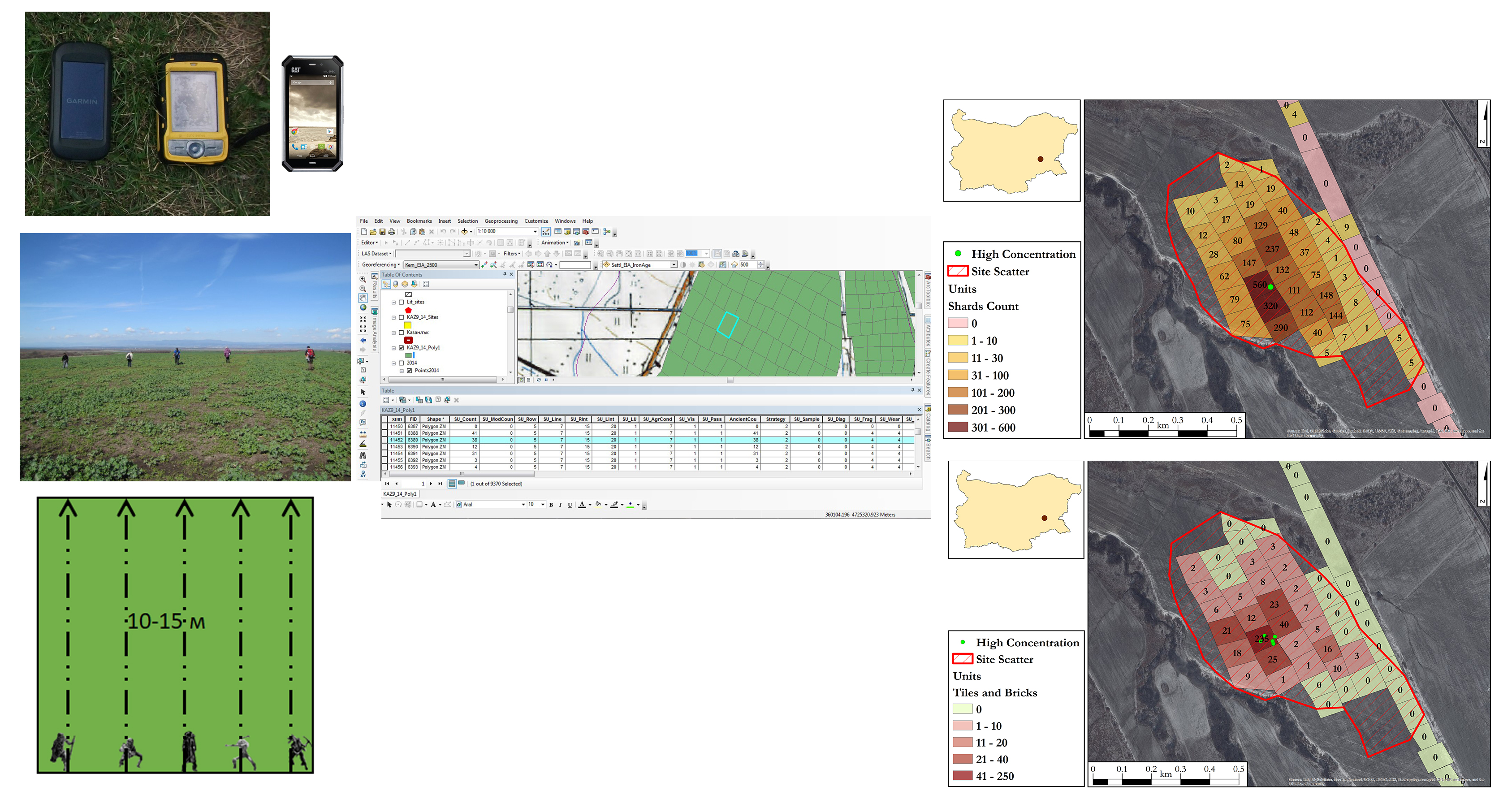
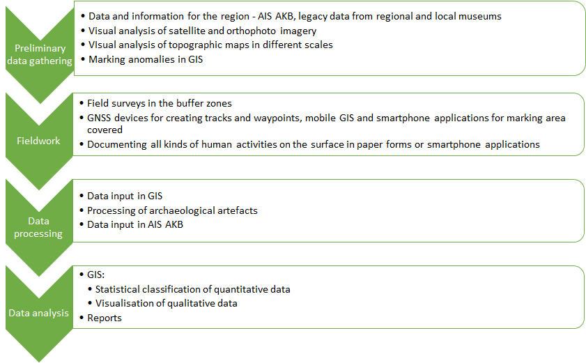
The centralised structure controls the quality of the work. Field surveys, being the first step of the fieldwork for development-led projects, are an important part of the whole process. The process also includes several steps (Table 1). The first is office-based, with preliminary data gathering – data from the national archaeological information system 'Archaeological Map of Bulgaria', legacy data, grey literature studies, analysis of remote sensing imagery, and information from regional and local museums. Field surveys are conducted using established and standardised methods for full documentation of field characteristics and archaeological materials using application of GIS technologies in the field and in the office (Нехризов 2012; Tzvetkova et al. 2012) (Figure 1). They include covering the whole buffer zone of the linear infrastructure route by field-walking using GNSS receivers, mobile GIS devices and smartphone applications. Data are systematically collected, with the team members 10 to 15m apart. Plotting the archaeological artefacts recovered helps to show their higher concentrations in an exact geospatial location. Based on them, and on the field observations, approximate scatters/borders of the archaeological sites are defined in GIS software.
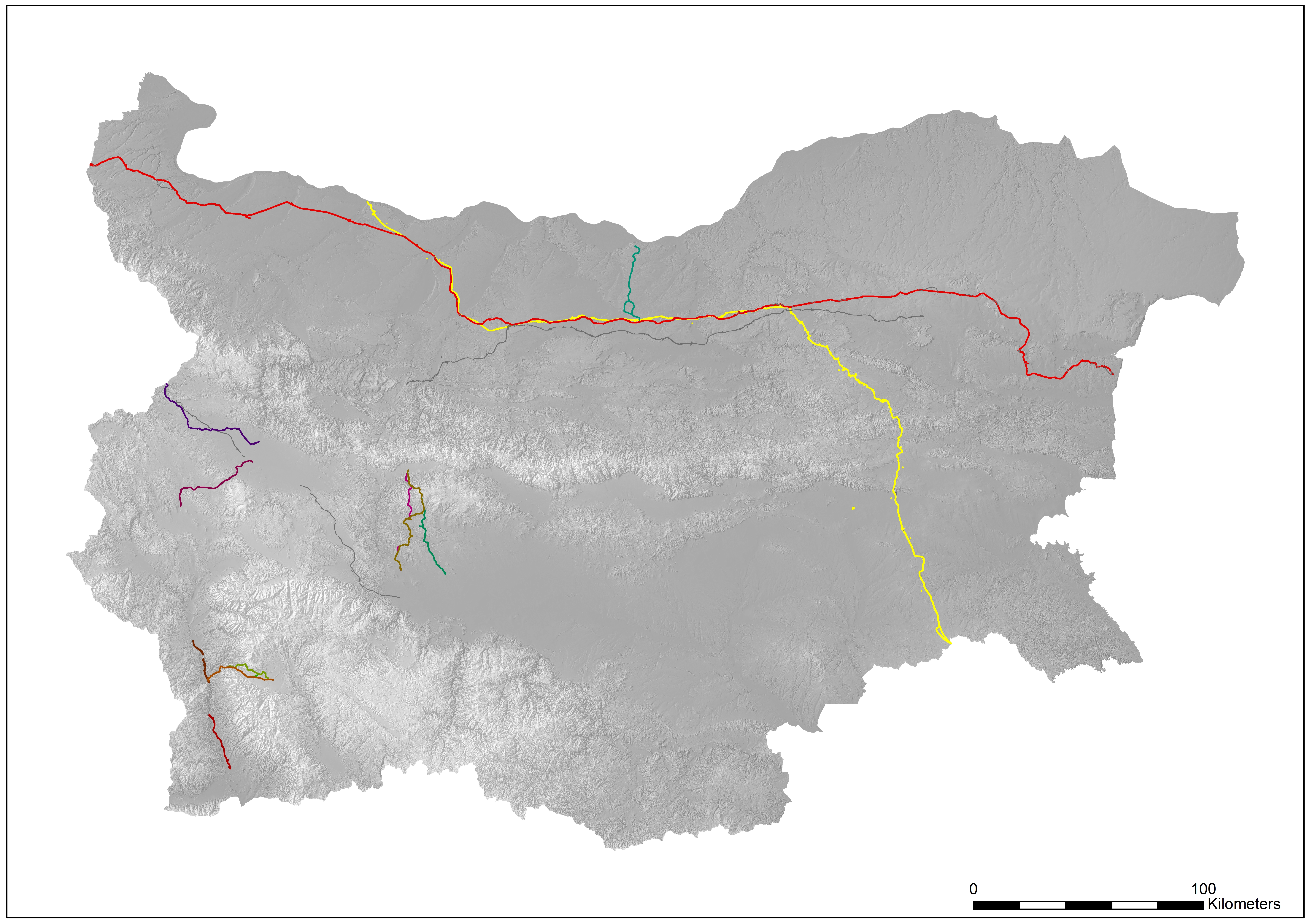
A lot of transport and pipeline infrastructure projects were carried out in the same standard way – paid for by the developers and executed by NAIM-BAS (Figure 2). The first was the Nabucco gas pipeline project in 2011, which resulted in covering 30km² of the Bulgarian territory, using six teams and a total of 36 archaeologists involved in the fieldwork. Infrastructure projects continue with the South Stream gas pipeline project in 2012 and 2013, local pipeline projects in 2013, transport infrastructure (such as highways and railroads of national importance) in 2014-2017. As a result, more than 170km² were covered and more than 500 sites were registered (for the period between 2011 and 2016). Working with state agencies for transport and railroad routes results in good collaboration between both scientists and developers, with precise data collected in the field, full documentation, execution on time, and detailed final reports.
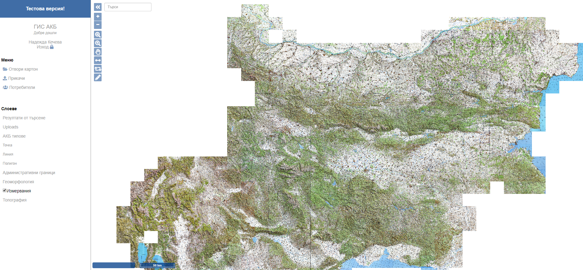
The transport and pipeline infrastructure projects carried out in the period 2011-2017 resulted in the accumulation of large amounts of standardised field survey geospatial data. These data contribute to a change in the 'sites and monuments' register-type information system to an archaeological geographic information system based on standardised geospatial data for specific geospatial features (Figure 3). These geospatial features include point, line and polygon features with predefined attributes. An example of a polygon feature type is area covered, which is based on standardisation of observations made at the time of the field surveys (Table 2).
| Polygon/unit | AKB feature type | Description | Additional mandatory attributes | ||
|---|---|---|---|---|---|
| Area covered | Marking of area covered by separate polygons/units | Field name | Visualisation | Code | |
| Land use | Бунище | dump | |||
| Гора | forest | ||||
| Градска територия | urban | ||||
| Нива | field | ||||
| Пасище/ливада | pasture | ||||
| Скала | rock | ||||
| Трайни насаждения | perennial | ||||
| Land cover | Градска територия | urban | |||
| Засята/бранувана /ожъната нива | seeded | ||||
| Иглолистна гора coniferous | forest | ||||
| Изорана нива/буци | ploughed | ||||
| Лозе | vineyard | ||||
| Овощна градина | orchard | ||||
| Скала | rock | ||||
| Смесена гора | mixed forest | ||||
| Тревна растителност | grass | ||||
| Храстова растителност | scrub | ||||
| Широколистна гора | deciduous forest | ||||
| Visiblity | 0-20% | 0-20% | |||
| 20-40% | 20-40% | ||||
| 40-60% | 40-60% | ||||
| 60-80% | 60-80% | ||||
| 80-100% | 80-100% | ||||
| Strategy | В труднодостъпен терен | ATS | |||
| До 15 м | I | ||||
| М/у 15-30 м | E | ||||
| Pottery | Number, default 0 | ||||
| Daub | Number, default 0 | ||||
| Brick and Tile | Number, default 0 | ||||
| Stones | Number, default 0 | ||||
| Flints | Number, default 0 | ||||
All the successful large development-led transport and pipeline infrastructure projects show the efficiency of the existing structured and centralised system in Bulgaria. The control and the standardisation improve both scientific and methodological framework. Accumulated standardised data is very useful in a centralised archaeological information system such as 'Archaeological Map of Bulgaria'.
The author would like to thank the whole team working on the archaeological information system 'Archaeological Map of Bulgaria' whose leader is Assoc. Prof. Dr. Georgi Nekhrizov, NAIM-BAS. The author would also like to thank the former director of NAIM-BAS, Assoc. Prof. Dr Lyudmil Vagalinski, who has steered the developed strategy and workflow to this point.
Internet Archaeology is an open access journal based in the Department of Archaeology, University of York. Except where otherwise noted, content from this work may be used under the terms of the Creative Commons Attribution 3.0 (CC BY) Unported licence, which permits unrestricted use, distribution, and reproduction in any medium, provided that attribution to the author(s), the title of the work, the Internet Archaeology journal and the relevant URL/DOI are given.
Terms and Conditions | Legal Statements | Privacy Policy | Cookies Policy | Citing Internet Archaeology
Internet Archaeology content is preserved for the long term with the Archaeology Data Service (ROR). Help sustain and support open access publication by donating to our Open Access Archaeology Fund.