The Green, where the medieval Carmelite friary lay, is an area of considerable antiquity and by the later medieval period can be considered something like the unofficial 'religious centre' of the burgh. This brief section considers the term 'the Green' when it is used in historical documents. It explores what geographical area is being indicated by the use of the term and also what the name itself means.
In discussing the Green one of the first problems is in defining the precise area in question. This is especially true of the oldest documentary references. In one sense the Green refers simply to the street which ran (and continues to run) through a wider area of the burgh. This street was known variously as the Green, the Green Gate or the King's Common Highway (Via Regia). However, in certain documents the Green also refers to a wider area, in fact it refers to one of the medieval city's four administrative quarters.
The earliest documentary references to the Green generally refer to a parcel of land in 'the way of' the Green. For example: 'de illa terra jacente in vico viride…' dated 14 August 1399 (Dickinson 1957, 60) or in 1384 'vico de Grene…' (Thomson 1894, 252) 'vna terra jacente in vico de ly Grene' in a charter dated 4 October 1434 (Stuart 1844, 5) and 'in vico de la Grene…' on 5 October 1439 (Stuart 1844, 6). The term 'vico' is a weasel word (Cripps in Smith 1985, 29). It appears to be straightforward in meaning, indicating a street or paved way. However it often refers to the wider area, rather than just the street and the houses and plots of land immediately on the main street itself. In fact what historically is being spoken about is the area, rather than a small carefully delineated street.
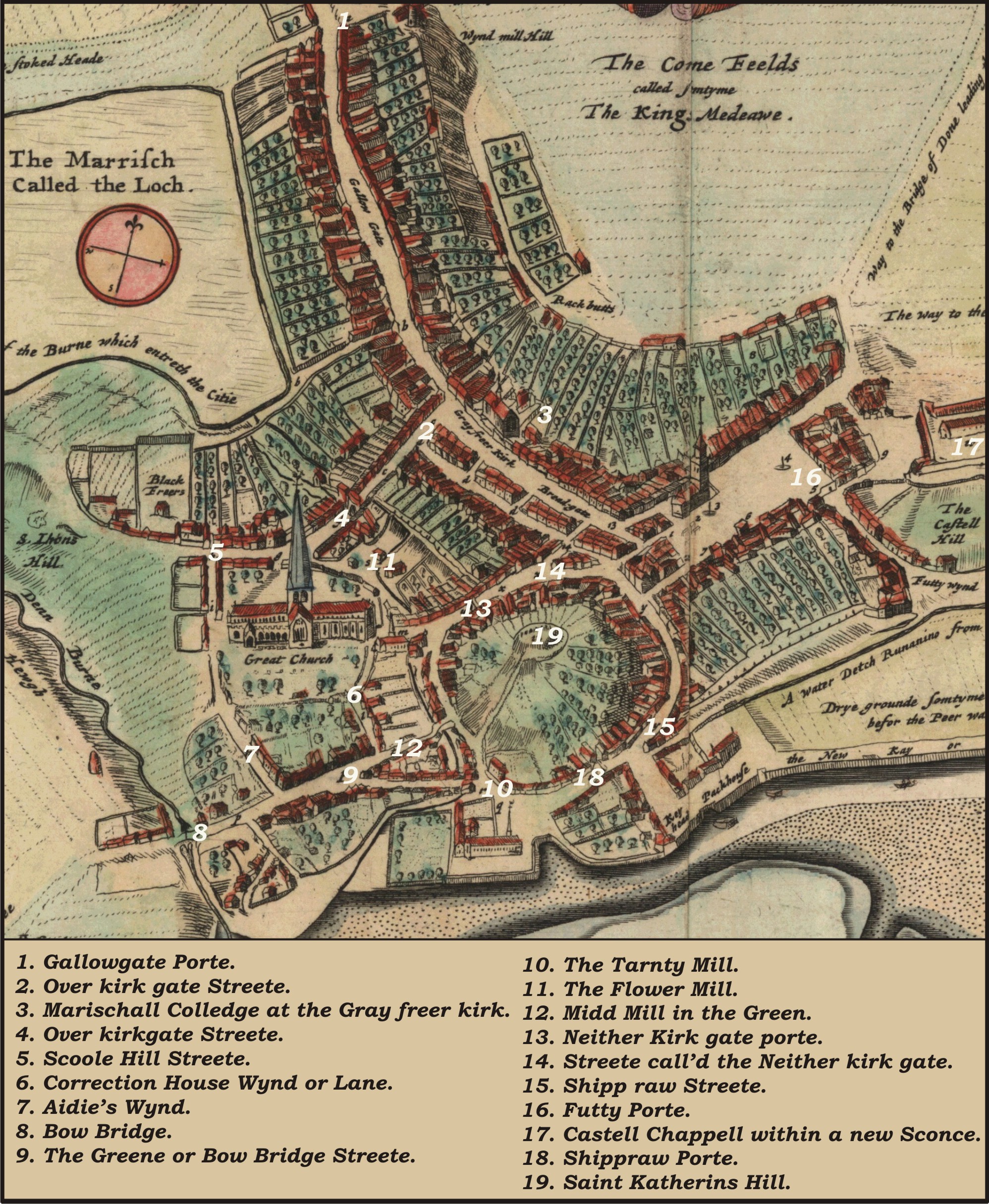
The Green, in general terms, may be taken to start after one had crossed the Bow Brig (Figure 8), which crossed the Denburn. Running up to the Bow Brig was the main over land route into the Burgh, known as the Hardgate. The Hardgate ran to Aberdeen from the Bridge of Dee (built 1527). In many ways the Bow Brig was the entry into Aberdeen for travellers arriving by land rather than sea. The Denburn thus provided the western boundary of the Green. The Green then extended from the Bow Brig up to what was the foot of St Katherine's Hill. To the south the Green was marked by a natural boundary, namely the river Dee and the harbour area. To the north the Green was bounded by the southern extremity of the graveyard of Aberdeen's parish church, St Nicholas (see Section 4.5.2)
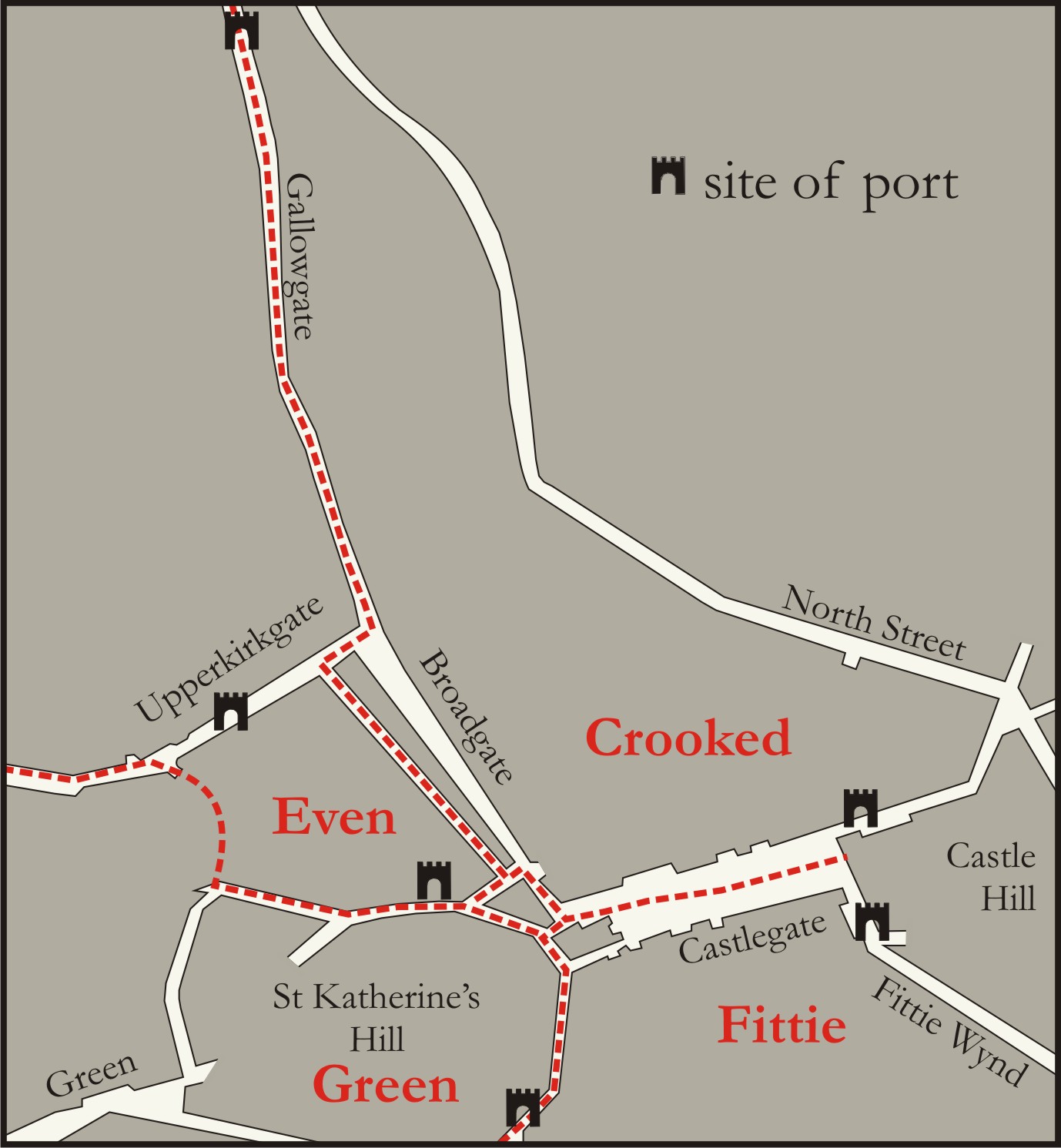
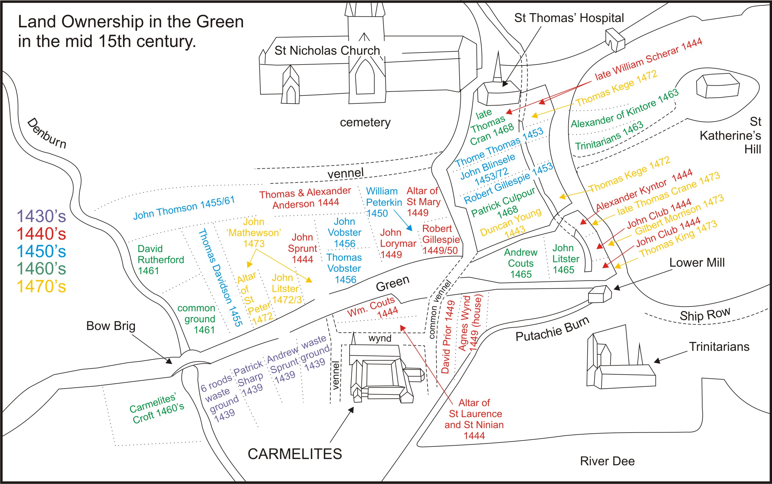
From at least as early as the 14th century (but no doubt earlier) the Green, as an area, was one of the four quarters into which the Royal Burgh of Aberdeen was divided for administrative purposes (Figure 13). This was common practice throughout Scotland and happened in a number of other burghs. In Aberdeen the first evidence for this comes from 1399 when the four different quarters were the Greenside, Vicus Ecclesie, Futty and Gallowgate (Dickinson 1957, 180). After 1449 the quarters settle into what became their regular names for the next few hundred years: the Green, Fittie, Crookit and Even quarters. These quarters were for the benefit of administering the medieval burgh, specifically for tax purposes (also called stents) and for wapinschaws. However, various other parts of burghal administration were based around the division of the burgh into quarters. Fittie was the poorest of the quarters and the Green next. Bob Tyson points out that the people who paid the highest taxes were in fact spread evenly throughout the four quarters, as the wealthiest were to be found around the Castlegate area where the four quarters met (Tyson in Dennison et al. 2002, 126). Nevertheless proportionally more rich people (or put another way more tax) came from the Crookit and Even quarters than from Fittie or the Green.
The name, the Green, seems to suggest an open space or grassy meadow area. There is some limited evidence for this interpretation of the meaning of the name. Douglas's description of the area dating from 1782 notes that the Green was 'a piece of common pasture till the year 1757…' (Douglas 1782, 143). However, Parson Gordon's Map of 1661 shows a well developed area in the Green (Figure 8). Unless the Green had experienced a change in use over the hundred or so years between Gordon and Douglas it would seem that Douglas was wrong. Ultimately it may be best to discount the comments of Douglas as even Patterson's map of 1746 shows the Green as being a well-developed urban area. The research conducted thus far also points to the Green as being a well-developed area by the 1450s with a considerable amount of property holding and development, both industrial and domestic.
The meaning of the name Green does not in fact bear out this interpretation of an open space, but rather suggests a road leading to an open space. Fraser has pointed out that the name is a shortened version of what once was 'Green Gate' (Fraser 1904, 8). There are a number of references to this version of the name: for example there is the comparatively late date of 1560 when the Green is habitually referred to as 'the Gren Gait…' in the Books of Assumption (Kirk 1995, 418-9). The Green Gate is thus the street that led to the green, in this sense the street leading to the open green, which lay, therefore, on the other side of the Denburn, across the Bow Brig. Thus, the Green is named from the perspective of one in the centre of the burgh looking out at what lies across the ford over the Denburn (or Bow Bridge depending upon the period). It has also been suggested that Green may derive from the Gaelic word grahine (meaning a sandy or gravelly area): however this suggestion is unlikely to be correct (Milne 1912, 183). There are, or rather were, parts of the Green where this was undoubtedly the case. However, the evidence does not seem to warrant putting this name into a Gaelic straight-jacket, where a perfectly acceptable alternative meaning of the name exists.
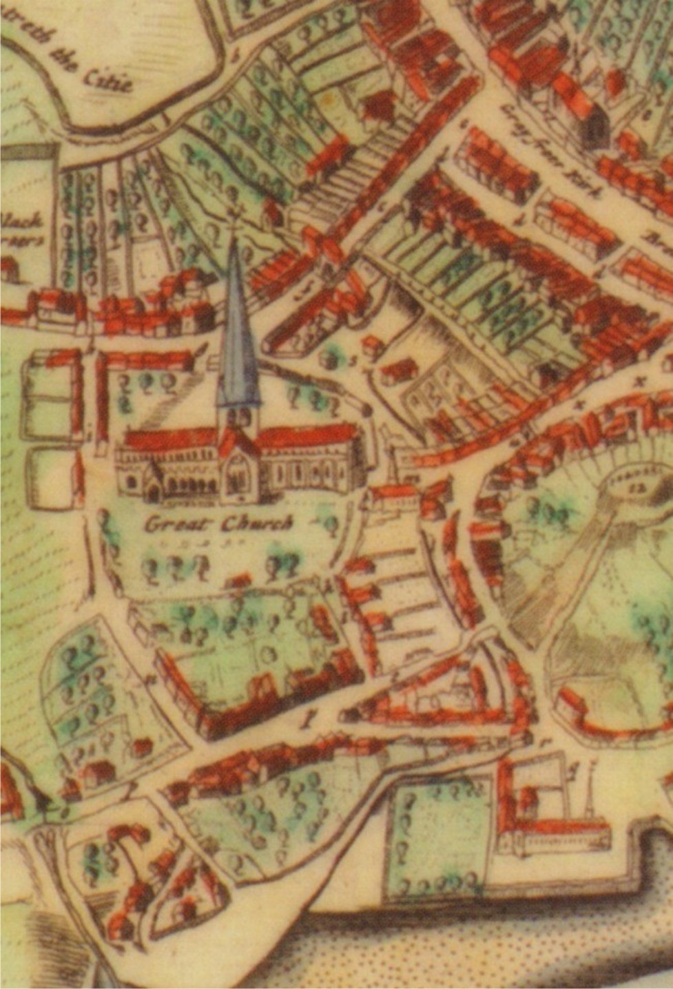
The Green is bordered on the south by the channel of the River Dee as it approaches its mouth and the North Sea. Consequently land to the south of the Green was in early times waterlogged and this meant that the land had to be reclaimed. Indeed waterlogging remained as a significant landmark in the area for some time. Thus a charter of 1558 refers to a tenement and yard in the Green which was bounded by the 'fluxu mares versus austrum…' (UA MS M390/12/37). Although it should be noted that flooding was a problem in the Green for some considerable time, this may be due to the second natural boundary of the Green, the Denburn. The Denburn was prone to flooding in Spring, due to the addition of melt water. This may account for the following curious record from 1755 which notes that 'an e sower ion was taken against John Harrow Salmon fisher for building a stair too near the floodmark upon the Road leading from Pionard nook to John Auldjoes Brick Kiln.' (ACA, Fletcher's Minute Book 1740-1779). This provided a significant water source for the residents of the Green. To the east another natural border for the Green was the base of St Katherine's Hill, whilst to the north the area was bordered by the southern wall of St Nicholas Church yard (Figure 14).
Given that the Hardgate formed the main entry into Aberdeen from the south a bridge over the Denburn would have been a crucial structure. Therefore, the Green from a very early time must have been served by a structure across the Denburn. Unfortunately, there are no records for the building of the first, but it is most likely that there had been one in the area for a long time. The first record we have which definitely indicates the presence of a bridge dates from 1444 and it mentions John Stokar's lands in the Green beyond the bridge (Cooper 1892, 54). The next comes from the burgh accounts of 1453: it states, 'Item, for mendyng of the brig at the grene ende in all costis, 1 lib 2s 6d' (Stuart 1852, 48). This in fact is not a huge amount of money; thus it may be possible to assume that it was a wooden bridge. However, it remains likely that a bridge had been in the area from the thirteenth or even the twelfth century.
The most famous of the bridges which crossed the Denburn was the Bow Brig (Figure 8). The date for the building of this is uncertain, but the first mention of the Bow Brig dates to 1506. In a charter of 27 February 1506 a piece of land is described 'In vico viridi quo itur ad ly bowbryg…' (UA MS M 390/12/33). Thus the Bow Bridge was certainly in existence by 1506, although whether or not this was the same bridge as the one mentioned in 1453 cannot be determined. At any rate the term bow in this sense refers to an arched bridge and when the term is used it is probably indicating a stone bridge. In a charter of c.1530 a property boundary is described as including the 'powbrig'. Pow is a word derived from Gaelic meaning burn, although it is also possible that this was a slip of the pen, and that this refers to the bow brig, but this remains intriguing and may point to another origin for the name (Cooper 1888, 161).
A possible second incarnation, and indeed second bow, was envisaged in 1556. On 2 January that year the council voted to build a 'brig of tua bowis…'. Moreover this work was to be organised by the master of 'vark of the brig of Dee…', with funding coming from that source (Stuart 1844, 294). It is entirely uncertain whether or not this project went ahead, but thirty years later plans were mooted that 'a bow brig be biggit and erectit with ane bow of estlair…' (Stuart 1848, 59). However this entry does not specify where this bridge was to be erected. At any rate a bow brig certainly existed, and was of one arch, or bow, and it was repaired in 1587 when Malcolm Wadderburn was made a burgess in consideration 'of his pains in bying of 3 scoir peaces of stains in Dundye to the bowbrige…' (Moir 1890, 80). Moreover in 1597 the treasurer of the burgh paid William Findlaye, the calsay maker £12 for having put down the calsay on the Bow Bridge (Stuart 1852, 122).
Plans were again mooted for a change in 1610. At that time it was stated that the bridge which was in existence had one bow. Moreover this was a problem 'be e sow of the invndatioun of great spaittis of watter was nocht sufficient nor habill to ressaue the e s water…be e sow that said ane bow e sower litill and narrow…' The entry in the Council Register went on to say that at the last inundation the bow was partially demolished and the water flooded the corn and malt barns that were adjacent. In consequence it was decided that a two-bowed bridge was to be built (Stuart 1848, 300).
This incarnation of the Bow Brig survived until the middle of the 18th century. The Denburn overflowed on 4 October 1746 and the effects of this were aggravated by the two arches of the Brig (ACA Council Register LXI, 283). This resulted in a public clamour for the Brig to be rebuilt with one arch. The new Brig was begun in 1747 to a design by the mason, John Jeans (Fraser 1904, 41). The Bow Brig was finally removed in 1850 to make way for the Denburn Valley Railway. At that time the arches of the Brig were taken to Union Terrace Gardens, where part of it was incorporated into the arches which support Union Terrace itself (Fraser 1904, 41).
It is clear that the main street layout in the Green was in place by the fifteenth century. That is to say that once the Denburn had been crossed the King's Highway (that is to say the street known as the Green and called Bow Brig street by Parson Gordon) then led to the foot of St Katherine's Hill. Presumably this would have been the oldest of the streets in this quarter of the burgh. All of the further streets which developed in the area led from the Green (or King's Common Highway) to allow access to buildings and riggs which developed later. The Green street ran (from the Bow Brig) on a west-east axis. As the east end was approached the street widened into a large 'v' shape; the interior of which was colonised by houses. The second street which can be traced with some accuracy is what is now known as Correction Wynd, which existed for some time before it assumed its modern name (Figure 8). A charter dated 1444 mentions 'the common vennel which lies on the east side of the Cemetery of the Church of Saint Nicholas…' (Cooper 1892, 53-4). Later, in 1453 there is a reference to a plot of land that was bounded by 'the King's common highway that comes from Saint Nicholas on the west and the mill lade of the lower mill on the east.' (UA MS M390/12/47). It assumed its modern name after the House of Correction was erected in 1637. For example, in 1763: 'the Gate leading from St Nicholas parish kirk to the Carmelite ffryars…the wynd commonly called the Correction wynd…' (ACA Sasines Register 64, fo 23v). Correction Wynd still runs in its ancient course along the side of St Nicholas church down to the Green. Its pathway was unaffected by the construction of Union St which was in fact built over the top of Correction Wynd, although the street today is largely eighteenth century in appearance and is entirely built of granite.
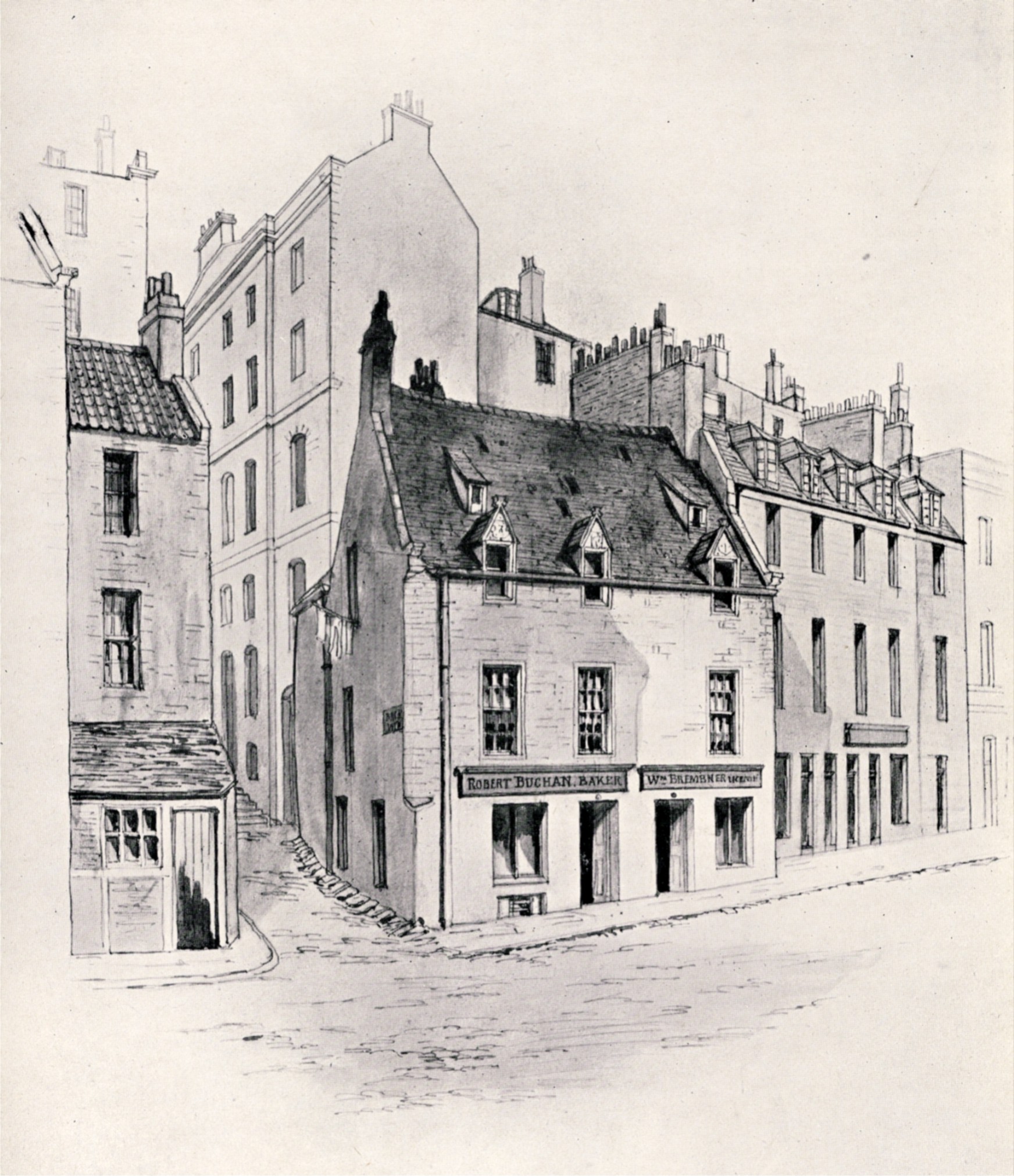
What we know as Back Wynd is also an ancient street that was generally known as a 'common vennel' leading from St Nicholas to the Green. The street itself seems to date from 1594, when it was formally laid out, by Aberdeen Burgh Council (ACA Council Register XXXVI, 140). However, on Parson Gordon's Map of 1661 Back Wynd is called Aedie's Wynd (Figure 8). This name would arise because of the presence of Aedie's House at the junction of the Green and Back Wynd (Figure 15). However, a sasine of 23 June 1758 referred to it as 'the wynd commonly called the kirk or Back Wynd' (ACA Sasines Register 62, fo 148r).
It can be said that the presence of the friary (and indeed St Nicholas church) affected the evolution of streets in the Green in the fifteenth century. There is a reference to a 'wynd along the Carmelites walls…' as lying to the south of the land of William Coutis, whose land was in front of the Friary, hence the wynd along the Carmelites' walls was on the north side of their place (Cooper 1892, 326). Moreover, the lands of Coutis were elsewhere described, in 1453, as being bounded by public vennels on the east, south and west (ACA Register V, I, f.171). This can be interpreted as two vennels leading off the King's Common Highway (or the Green proper) to the Carmelites and probably were in themselves continuations of what we know as Back and Correction Wynds (Figure 12).
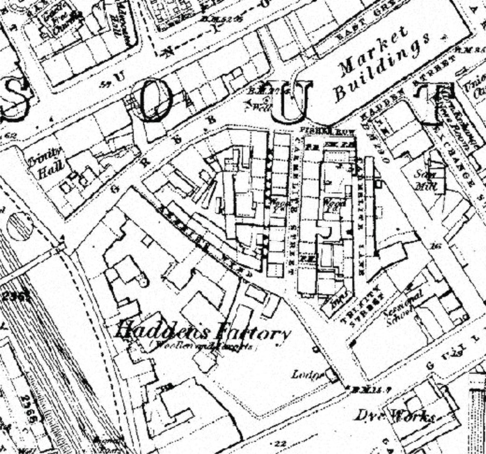
Moreover, it would seem that the road to Poynernook croft was also in existence at an early stage. From the evidence assembled from a number of different charters it can be said that this street is what we know as Rennie's Wynd. This can be said because of the presence of the friars' kiln at the bottom of the street in the post-Reformation period and because the site of the kiln was later filled by Hadden's factory (Figure 10). Other aspects of the street plan and layout of the Green have been lost over the centuries. Thus the three vennels that led from the King's Highway to the Carmelites were no longer needed after the Reformation and probably were swept away then, indeed they do not feature on Parson Gordon's map. The modern street layout of the Green, of Carmelite St and Lane along with Martin's Lane all date from the eighteenth century at a time when the pattern of land ownership and usage changed in the burgh.
As there was a 'cawsamakar' recorded in the burgh as early as 1399 then it would seem fair to assume that the King's Common Highway in the Green was paved with loose stones from at least the later fourteenth century (Dickinson 1957, 87). Moreover, it might seem fair to suggest that the street that led from St Nicholas church to the area of the Carmelites would have been paved also, although there is no evidence for this. There is certainly evidence from later on in the sixteenth century that the burgh's officials were becoming concerned that the roads around and leading to the burgh (more than just those outwith the ports) should be paved and that responsibility for this should fall to the burgh's calsay maker. Again there is no direct evidence for how this related to the Hardgate and the area leading to the Bow Bridge but given the importance of that bridge as an entry to the burgh then perhaps the Hardgate had been paved for some time.
The presence of two of the burgh's mills in the Green also affected the topography of the area. The first documentary reference to the mill lade running through the Green dates from 1444 when the lands of John Club, dyer, in the Green, were described as lying on the east side of the aqueduct (Cooper 1892, 53-4). The presence of this mill lade meant that the riggs of land on either side were short and stubby in appearance rather than elongated. This mill lade came from the loch and ran to the flour mill and from there down through the Green and into the Dee as it approached the sea (Figure 8. This mill was later supplemented by the lower or Trinity (or Tranty) mill. The lower mill was in the Green from 1453, although Dennison suggests that it may have been from 1459 (Dennison and Stones 1997, 77). A charter dated 3 March 1453 mentions the 'torrent molendim inferioris…' (UA MS M390/12/48) A third mill, known as the mid mill, was added in the north east of the Green in 1619 (Dennison and Stones 1997, 17).
The Trinitarian friary was also located in the Green. However it sat slightly apart from all other buildings in the Green and hence did not effect the development of the Green in the direct sense that the mill lade did.
Internet Archaeology is an open access journal based in the Department of Archaeology, University of York. Except where otherwise noted, content from this work may be used under the terms of the Creative Commons Attribution 3.0 (CC BY) Unported licence, which permits unrestricted use, distribution, and reproduction in any medium, provided that attribution to the author(s), the title of the work, the Internet Archaeology journal and the relevant URL/DOI are given.
Terms and Conditions | Legal Statements | Privacy Policy | Cookies Policy | Citing Internet Archaeology
Internet Archaeology content is preserved for the long term with the Archaeology Data Service (ROR). Help sustain and support open access publication by donating to our Open Access Archaeology Fund.