Mini journal logo  Home Summary Full text Issue Contents

Stratigraphic Analysis and The Matrix: connecting and reusing digital records and archives of archaeological investigationsOpen Materials

Keith May, James S. Taylor and Ceri Binding

Cite this as: May, K., Taylor, J.S. and Binding, C. 2023 Stratigraphic Analysis and The Matrix: connecting and reusing digital records and archives of archaeological investigations, Internet Archaeology 61. https://doi.org/10.11141/ia.61.2

Appendix A – Stratigraphic rules and checks used in a Matrix diagram and incorporated in Phaser software

The Matrix project found that the drawing, layout and symbology of a Matrix diagram can vary somewhat between different archaeological practitioners, depending upon how the stratigraphic analyst chooses to depict certain basic 'rules'. Nevertheless, the most common approaches that were adopted by practitioners in the UK have been incorporated in a set of basic validation checks that are implemented in the Phaser software to enable these rules to be checked.

A.1. Checking of basic stratigraphic rules in the Matrix and Phaser

As outlined in Section 7.4, the Phaser software includes the functionality for the stratigraphic analyst to check, and to some extent choose, how rigidly to implement certain basic stratigraphic rules that need to be in place for their Matrix diagram to be consistent. This checking is enabled in the 'validation' tab in the prototype.

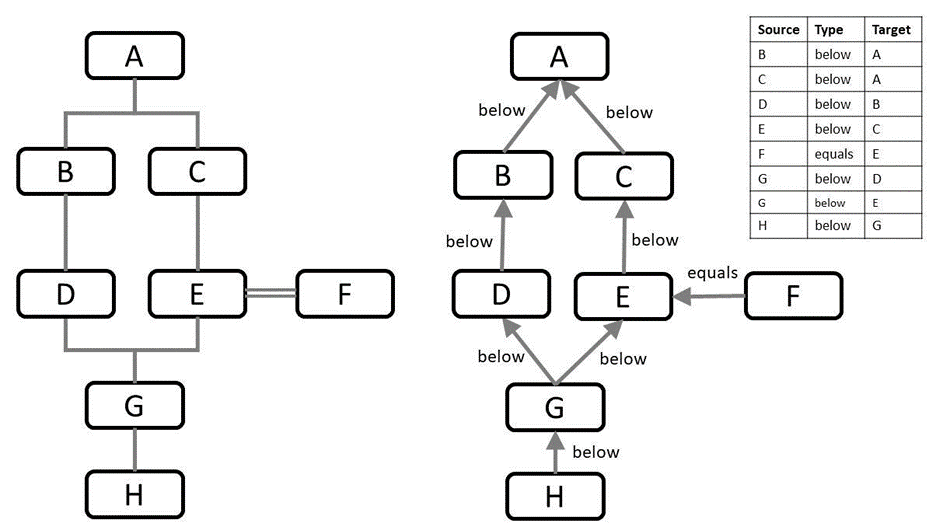
To maintain internal data consistency the software includes a series of checks of things such as 'every group must contain at least one context' and highlights any inconsistencies that may occur during the data entry and analysis updates. Every new context that is entered is included in this 'validation' checking and the relationships can be cross-checked at appropriate points in the analysis process. Examples of the basic internal checks that can be monitored in the 'Validation' tab are shown in Figure 17.

Figure 17: Video capture showing example use of Phaser 'Validation' tab. This example initially displays that contexts (NFE) (10000) and (+) have not been allocated to a phase and then shows in detail the process of validation checking of a context (1076) that is moved below another context (1067) and no longer reflects its recorded stratigraphic alignment.

These rules as implemented in Phaser are summarised in the simplified steps set out below (see also Appendix B).

A.1.1. Need for consistency in how to record 'Top' and 'Bottom' of the Matrix

One of the parameters to be checked is the denoting of the top of the stratigraphic sequence. In examples of datasets we worked with, it was not always clear if a convention had been used for this. The most commonly occurring example was the use of the '+' symbol to denote the uppermost context (e.g. in MOLA archives). In some archives, this '+' corresponds to a 'top of sequence'. In other examples (mostly from rural excavations), the term 'Topsoil' denoted the uppermost context in the stratigraphic sequence. Similar issues occurred with the terms used for the bottom of the sequence although, as explained below, it emerged these could involve further ambiguities.

A common expression for the bottom of the stratigraphic sequence was the term 'NFE', which is an abbreviation for 'No Further Excavation'. Other terms that were encountered were 'limit of excavation', 'excavation extent' and variations on a similar theme. Again the question of how widely these are used remains open. What seems clear is that it would be useful to adopt a uniform way of representing the bottom of an excavation in a Matrix diagram and the associated data records, once archaeologists have finished excavating (Recommendation 4.4). Similarly, various terms were used for where the surface of underlying geological layers and non-anthropogenic strata were encountered. Most commonly 'Natural', or 'Surface of Natural' is used, but it is not always clear if archaeologists are consistent in distinguishing between 'NFE' and 'SoN', and more often than not, archaeologists finish at NFE and do not feel it necessary to record whether SoN has been encountered.

The importance of this 'Surface of Natural' (SoN) is also highlighted by Matt Edgeworth in various publications on anthropocene studies where it is labelled as 'Boundary A'.

Few disciplines have any rigorous way of measuring depth of anthropogenic ground. Soil science and geology for example do not generally recognize or record the division between natural ground and human-modified ground. But archaeologists routinely find and follow along an interface in the ground known in the UK as 'the surface of the natural' – which I call Boundary A (Edgeworth et al. 2015). It is not always clear-cut or easy to discern. But where found it can be mapped in three-dimensional space. A simple set of recording protocols (to be added on to existing recording procedures) could focus on documenting this interface - its approximate depth below ground surface over the whole site, and some general characterisation and dating of it (Edgeworth pers. comm.).

'Boundary A' can also be equated to something described elsewhere as the 'Jinji':

Archaeologists sometimes informally refer to it as 'the surface of the natural'. Geologists in Japan call it the Jinji unconformity, which when loosely translated means the conjunction of human and natural' (Edgeworth 2018).

Understanding the significance of attempts to trace this Boundary A at scale across the whole of the Anthropocene using multiple excavation records, might emphasise and underline to other archaeologists the importance of consistency in their records to enable better reuse by others. Experience so far on the Matrix project seems to show only limited consistency in how archaeologists from different organisations actually document the 'top of natural' and not much better for Limits of Excavation/NFE. That said, most excavators do have some convention for how the extents of excavation are documented, so it ought to be possible to locate and semantically join those up across different excavations by different organisations.

There may also be considerable public benefit in incorporating non-archaeological approaches to this information along with archaeological records. For example, once construction is underway, often the footprints of excavations for most development sites go much deeper or wider than where the archaeologists decide the 'earlier archaeology' stops. It would be advantageous to future archaeologists, as well as others who come after, to tie in the bottom of the recorded archaeological horizons (e.g. NFE by construction teams) with any subsequent development activity. Some forms of Building Information Modelling (BIM) are now used on major infrastructure projects, and these would be worth more investigation with construction firms who often change or extend the Jinji boundary much deeper when digging their new foundations after all the older archaeology has been excavated. Also geoscientists have plenty to offer on how to record 'natural' stratigraphic boundaries most effectively (Coe 2022), although attempts to find whether geoscientists use anything like a Harris matrix to analyse their stratigraphic data seems to have proved less fruitful so far.

A.2. Expressing Allen operators for temporal relations and using the implicit temporal relationships between the matrix data fields

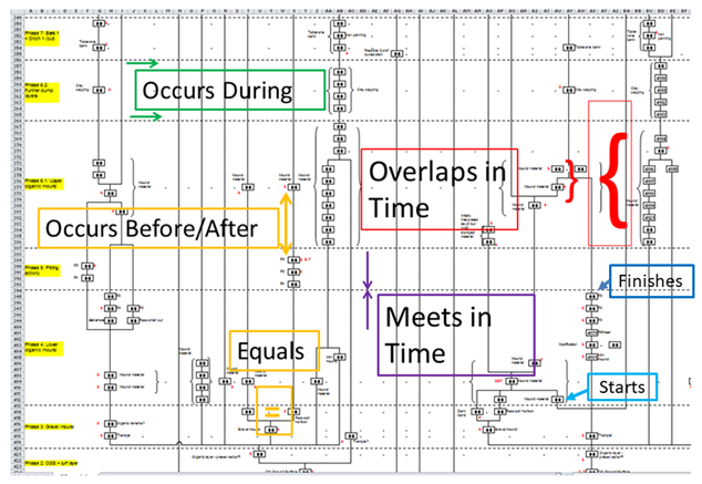
It has been demonstrated previously (May 2020) that commonly expressed versions of stratigraphic Harris Matrix diagrams (Harris 1989) contain not only the explicitly recorded stratigraphic relationships of Before, After and Equals, but also an implicit set of temporal relationships (Figure 18) as defined by J.F. Allen and commonly known as the Allen Temporal Operators (Allen 1983).

Allen temporal operators annotated on an original Excel spreadsheet to show the temporal relationships implicitly in Harris Matrix diagram of Silbury Hill
Figure 18: Allen temporal operators annotated on original Excel spreadsheet to show the temporal relationships implicitly in Harris Matrix diagram of Silbury Hill, downloaded from ADS archive.

One aim in developing Phaser is to increase the explicit expression and more consistent use of the temporal relationships implicit in Matrix diagrams. This has been shown in the Phaser software by highlighting where the temporal relationships between contexts and (sub)groups correspond to the Allen temporal operators, derived by comparing the date ranges in the dating records for each context (or group). The temporal relationships between the different contexts with dating evidence are shown in tables expressing the 'derived temporal relationships' between each element within a chosen phase. In current practice, much of the analysis work undertaken, particularly use of the Harris Matrix diagram as the tool to 'work out' stratigraphic and phasing relationships (temporal relations), does not result in the temporal reasoning and relationships being recorded in the final data records. Often a paper copy of the matrix results, but this (or even a digital PDF copy) is not reusable without an inordinate amount of work to re-key individual data items back into a usable database format. Although those interested can view a Matrix diagram, it is not easy to navigate (especially a large complex example) without a very detailed knowledge of the individual site that each different diagram represents (Paice 1991).

A.3. Use of Allen operators for checking the Matrix as implemented in Phaser

The Harris matrix covers all stratigraphic relationships between stratigraphic units (contexts) as recorded by observation and excavation during fieldwork. The analysis work of grouping and phasing those stratigraphic units involves, indeed requires, the stratigraphic analyst to sequence the matrix using the stratigraphic relationships but also by incorporating any dating evidence that results from analysis of finds, and scientific dating by other experts working on such material recovered from the stratigraphic units. The stratigraphic analyst must deduce and incorporate additional interpretation of the temporal relationships, alongside inferred spatial relationships that are derived from checking the spatial records, more often these days using a GIS alongside the matrix tools (Taylor 2016; and see Figure 10).

The Matrix project has formulated a method for recording a comprehensive temporal model, based upon the Harris matrix methodology, for all the possible stratigraphic (spatio-temporal) and temporal relationships that can hold between a sequence of stratigraphic units recorded in the field (Figure 12). This method has been incorporated in the Phaser software tool (see discussion in section 7.5) and the Allen relationships have been implemented using a set of functions to determine the relationship between any two ranges of years (start year/end year). These functions are coded according to the rules detailed in Binding 2010.

A.4. Making the Allen Temporal Relationships explicit using stratigraphic relations and dating evidence

Including the Allen relationships more explicitly in the matrix analysis makes the reliance upon the dating evidence also more explicit. This brings to the surface the varying degrees of (un)certainty in the dating evidence, which is to some degree masked when the matrix is presented as a purely stratigraphic record. Yet we would argue that without the role of the dating evidence explicit in the grouping and phasing dating processes then the fundamental evidence underpinning the interpretative outputs remains 'buried' in the archive.

Where dating evidence is available for finds within a single context, the Phaser software will calculate a derived date for the overall context, based upon the earliest 'minimum' date entered for any find from that context and the latest 'maximum' date entered for any find from the same context. This results in a derived overall duration – earliest start date to latest end date – for each context.

A.5. Incorporation of Terminus Post Quem (TPQ) and Terminus Ante Quem (TAQ)

During development, the project team considered building in TPQ and TAQ functionality to Phaser but did not have clear guidance to follow on how best to do so. Therefore it remained on the 'nice to have' list of requirements. After the final project workshop, correspondence with MOLA staff provided the following piece of feedback that might form the basis for how to incorporate TPQ and TAQ functionality when managing the dating evidence.

'The TPQ and TAQ dates are assigned to the context, and the E_Date and L_Date are assigned to each specific finds category from that context, so they can and do differ if there are residual/intrusive finds, or if one finds category has particularly tight and convincing dating.'
'It might help to explain how the form is completed. The specialists enter the data, and the first specialist using the form (usually ceramics) will assign TPQ and TAQ dates to the context based on their assemblage. As other specialists add dates for their material they can review and revise the TPQ and TAQ dates for the context manually – the form is updated as the project progresses. Our regular finds specialists usually prefer for the dates and phasing to be driven by the overall phasing for the site (and use this information to assign dates to their objects), so that's why they haven't assigned E_Date or L_Date to their material – but the capacity is there for them to do so if it was relevant for a particular site' (Louise Fowler - MOLA pers. comm.).

In Phaser we did build in the functionality to 'exclude' any single item of dating evidence from the Min Year & Max Year derived calculations. In effect, the stratigraphic analyst has the ability in Phaser to exclude any dates and add their own TPQ or TAQ date to a context, but this will, and should, be shown explicitly and preserved in the data record.

A.6. Checking of derived dating evidence against stratigraphic relative dating (above/below/equals)

Phaser compares the derived duration of any stratigraphic units that have stratigraphic relationships recorded as part of the matrix (Figure 19). If the duration of the context is consistent with the stratigraphic record (i.e. Above/Below/Equals) then it will return green in the table of 'derived temporal relationships', but if there is an inconsistency between the stratigraphic record and the temporal duration recorded in the dating evidence then this will be highlighted in one of a number of ways by the software using a colour key.

In the second window (see Figure 20), this comparison of stratigraphic order against temporal duration is displayed with a different colour key to highlight the different possible matches or discrepancies. This is not meant to suggest these are definite errors in the data, but rather to highlight any discrepancies to the stratigraphic analyst so that they can check the relevant dating evidence against the stratigraphic record and decide whether there is a problem either in the dating, or possibly some error in how the stratigraphy has been entered in the matrix record.

Figure 19: Video capture showing example of checking derived temporal relationships displayed in Phaser 'Temporal' tab

The (Allen) temporal relationships are derived from dating evidence entered from existing XSM10 dating evidence taken from XSM10_coins_data01.csv and compared against stratigraphic relationships (as recorded in Stratify archived file XSM10_prebg_matrix01.lst) entered for all stratigraphic entities within a Phase 5.01 (as recorded in XSM10_iaa01.csv )

Colour coded discrepancies between stratigraphic relationships and temporal relationships derived from the dating evidence within each context
Figure 20: Colour coded discrepancies between stratigraphic relationships and temporal relationships derived from the dating evidence within each context

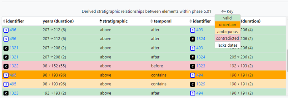
Limited dating evidence means many relationships remain unsubstantiated – i.e. there simply was no evidence to derive a temporal relationship. In this case, the matrix stratigraphic relationships still enable the basic checking, i.e. that the stratigraphic units are sequenced accurately.

A.7. Temporal validation in Phaser and potential user interface enhancement work

Adding in the Allen operators to express the complexity of the temporal relationships at a human interaction level has added a considerable degree of additional information for the archaeological user to work with. This enables the archaeologist to see more explicitly where there may be discrepancies between the stratigraphic relationships recorded for stratigraphic units and the dating evidence recorded for the objects retrieved from those stratigraphic units. We found, as we developed the Phaser application, that this additional information, although highly useful for checking dating correlations, needed some management through the user interface, to enable the nature of any discrepancies to be mediated and highlighted most helpfully to the user. In the prototype we have used various colour bandings to show different degrees of mis-match or agreement between the temporal relationships and the stratigraphic relationships (Figure 20). It would be feasible to give a user more control in choices of colours and rule expression as part of further software development, if considered useful.

Appendix B. Data Validation rule checks used in the prototype

We have provided the following list of the main examples of the rule checks used in the prototype software.

Stratigraphic Unit/Context

Group/Feature (group is more common)

Sub-Group

Phase

Period/Level ('level' more common in Ancient Near Eastern context i.e. Tells).

Diagram showing 3 possible matrix relationships
Figure 21: Possible relationships (Harris 1989, 36, fig.9)

The matrix system admits to only three possible relationships between two given units of stratification. In Harris' figure A, the units have no direct stratigraphic (physical) relationship; in B, they are in superposition; and in C, the units are correlated (equated by the = sign) as separate parts (given different numbers in the field) of a once whole deposit or feature interface (Harris 1989, 36).

Diagram showing stratigraphic relation inheritance between contexts, sub-groups, groups
Figure 22: Stratigraphic relation inheritance between contexts, sub-groups, groups

Appendix C. Relevant datasets available from ADS, for potential reuse in Phaser software

Aitchison, K., German, P. and Rocks Macqueen, D. 2021 'State of the archaeological market 2020', FAME report. https://famearchaeology.co.uk/wp-content/uploads/2021/10/State-of-the-Archaeological-Market-2020.pdf

Albuerne, A., Grau-Bove, J. and Strlic, M. 2018 'The role of heritage data science in digital heritage' in M. Ioannides, E. Fink, R. Brumana, P. Patias, A. Doulamis, J. Martins and M. Wallace (eds) Digital Heritage. Progress in Cultural Heritage: Documentation, Preservation, and Protection, Lecture Notes in Computer Science, Cham: Springer International Publishing, 11196. 616-22. https://doi.org/10.1007/978-3-030-01762-0_54

ALGAO 2019 Planning for archives: opportunities and omissions, https://historicengland.org.uk/images-books/publications/planning-for-archives/planning-for-archives/

Allen, J.F. 1983 'Maintaining knowledge about temporal intervals', Communications of the ACM 26(11), 832-43. https://doi.org/10.1145/182.358434

Altschul, J.H. and Klein, T.H. 2022 'Forecast for the US CRM Industry and Job Market, 2022-2031', Advances in Archaeological Practice 10(4). https://doi.org/10.1017/aap.2022.18

Alvey, B. 1993 'Interpreting archaeology with Hindsight: the use of three dimensions in graphic recording and site analysis' in E.C. Harris, M.R. Brown and G.J. Brown Practices of Archaeological Stratigraphy, London: Academic Press. 218-228. https://www.sciencedirect.com/book/9780123264459/practices-of-archaeological-stratigraphy

Archaeology Data Service and Digital Antiquity (eds) 2009 Guides to Good Practice, Archaeology Data Service, University of York, UK. https://archaeologydataservice.ac.uk/help-guidance/guides-to-good-practice/

Ove Arup & Partners, York University, English Heritage and York City Council 1991 York Development and Archaeology Study, Ove Arup & Partners,Manchester. https://www.york.gov.uk/downloads/file/1771/sd114b-english-heritage-and-york-city-council-york-development-and-archaeology-study-may-1991-part2

Balm, R. 2015 Archaeology's Visual Culture. Digging and Desire, London: Routledge. https://doi.org/10.4324/9781315673868

Barker, P. 1977 Techniques of Archaeological Excavation, Routledge: London.

Bayliss, A. 2009 'Rolling out the revolution: using radiocarbon dating in archaeology', Radiocarbon 51(1), 123-47. https://doi.org/10.1017/S0033822200033750

Berggren, Å. and Hodder, I. 2003 'Social practice, method, and some problems of field archaeology', American Antiquity 68(3), 421-34. https://doi.org/10.2307/3557102

Biddle, M., Hudson, D.M. and Heighway, C.M. 1973 The Future of London's Past; A Survey of the Archaeological Implications of Planning and Development in the Nation's Capital, Rescue (Trust) Publications, No. 4, Worcester.

Binding, C. 2010 'Implementing Archaeological Time Periods Using CIDOC CRM and SKOS' in L. Aroyo, G. Antoniou, E. Hyvönen, A. Teije, H. Stuckenschmidt, L. Cabral and T. Tudorache (eds) The Semantic Web: Research and Applications, ESWC 2010, Lecture Notes in Computer Science 6088, Berlin, Heidelberg: Springer. 273–287. https://link.springer.com/chapter/10.1007/978-3-642-13486-9_19

Bradley, R. 2006 'Bridging the two cultures - commercial archaeology and the study of prehistoric Britain', The Antiquaries Journal 86, 1-13. https://doi.org/10.1017/S0003581500000032

Börjesson, L., Sköld, O. and Huvila, I. 2020 'Paradata in documentation standards and recommendations for digital archaeological visualisations', Digital Culture & Society 6(2), 191-220. https://doi.org/10.14361/dcs-2020-0210

Bronk Ramsey, C. 2008 'Radiocarbon dating: revolutions in understanding', Archaeometry 50(2), 249-75. http://dx.doi.org/10.1111/j.1475-4754.2008.00394.x

Buck, C.E., Cavanagh, W.G. and Litton, C.D. 1996 Bayesian Approach to Interpreting Archaeological Data, Chichester: Wiley and Sons Ltd.

Carey, C., Howard, A.J., Knight, D., Corcoran, J. and Heathcote, J. 2018 Deposit Modelling and Archaeology, University of Brighton. https://www.brighton.ac.uk/_pdf/research/set-groups/deposit-modelling-and-archaeology-volume.pdf

Carver, M.O.H. 1979 'Three Saxo-Norman tenements in Durham City', Medieval Archaeology 23, 1-80. https://doi.org/10.1080/00766097.1979.11735413

Carver, M.O.H. 1987 Underneath English Towns: Interpreting Urban Archaeology, London: B.T. Batsford.

Carver, M.O.H. 1990 'Digging for Data: Archaeological Approaches to Data Definition, Acquisition and Analysis' in R. Francovich and D. Manacorda (eds) Lo Scavo Archaeologico: Edizioni all'Insegna del Giglio, Firenze: All'Insegna del Giglio SAS. 42-120.

Carver, M.O.H. 2009 Archaeological Investigation, London: Routledge.

Chadwick, A.M. 2001 'What have the post-processualists ever done for us? Towards an integration of theory and practice; and radical field archaeologies'. Paper given at Interpreting Stratigraphy Group Meeting, University of York, York. PDF

Chartered Institute for Archaeologists 2022 Dig Digital [website], https://www.archaeologists.net/digdigital [Last accessed: 11 November 2022].

Clarke, A., Fulford, M. and Rains, M. 2007 The Silchester Project: Roman Town Insula IX The Development of an Urban Property c. AD 40-50-c. AD 250 [dataset], York: Archaeology Data Service [distributor] https://doi.org/10.5284/1000259

Coe, A. 2022 Deciphering Earth's History: The Practice of Stratigraphy, The Geological Society of London. https://www.geolsoc.org.uk/GIP001 [Last accessed: 23 December 2022].

Cohen, K.M., Harper, D.A.T. and Gibbard, P.L. 2023 ICS International Chronostratigraphic Chart 2023/01, International Commission on Stratigraphy, IUGS. www.stratigraphy.org (Last accessed: 2 March 2023].

Conolly, J. and Lake, M. 2006 Geographical Information Systems in Archaeology, Cambridge: Cambridge University Press. https://doi.org/10.1017/CBO9780511807459

Costa, S., Beck, A., Bevan, A. and Ogden, J. 2013 'Defining and Advocating Open Data in Archaeology' in G. Earl, T. Sly , D. Wheatley, I. Romanowska, K. Papadopoulos, P. Murrieta-Flores and A. Chrysanthi (eds) Archaeology in the Digital Era: Papers from the 40th Annual Conference of Computer Applications and Quantitative Methods in Archaeology (CAA), Southampton, 26-29 March 2012, Amsterdam University Press. 449-56. https://doi.org/10.2307/j.ctt6wp7kg.50

Crossrail Ltd. 2019 Crossrail: Archaeological Investigations Conducted in Advance of Construction of the Elizabeth Line [dataset], York: Archaeology Data Service [distributor] https://doi.org/10.5284/1055125

Dell'Unto, N. and Landeschi, G. 2022 Archaeological 3D GIS, Taylor & Francis. https://doi.org/10.4324/9781003034131

Davies, D. 2017 The Development Of Archaeological Post-Excavation Within British Professional Archaeology, BAJR Guide 46 http://www.bajr.org/BAJRGuides/46_PostEx_Theory_Application/46%20Archaeological%20PostExcavation.pdf

Doneus, M., Neubauer, W., Filzwieser, R. and Sevara, C. 2022 Stratigraphy from Topography II. The Practical Application of the Harris Matrix for the GIS-based Spatio-temporal Archaeological Interpretation of Topographical Data, Archaeologia Austriaca 106, 223-252. https://doi.org/10.1553/archaeologia106s223

Dye, T.S., Buck, C.E., DiNapoli, R.J. and Phillipe. A. 2023 'Bayesian chronology construction and substance time', Journal of Archaeological Science 153. 105765. https://doi.org/10.1016/j.jas.2023.105765

Dye, T.S. and Buck, C.E. 2015 'Archaeological sequence diagrams and Bayesian chronological models', Journal of Archaeological Science 63, 84-93. https://doi.org/10.1016/j.jas.2015.08.008

Edgeworth, M. 2018 'Humanly modified ground' in D.A. DellaSala and M.I. Goldstein (eds) The Encyclopedia of the Anthropocene, Oxford: Elsevier. 157-161. https://doi.org/10.1016/B978-0-12-809665-9.09999-7

Edgeworth, M., deB Richter, D., Waters, C., Haff, P., Neal, C. and Price, S.J. 2015 'Diachronous beginnings of the Anthropocene: the lower bounding surface of anthropogenic deposits', The Anthropocene Review 2(1), 33-58. https://doi.org/10.1177/2053019614565394

English Heritage 1991 Management of Archaeological Projects 2 (MAP2), London.

Farid, S. 2014 'Timelines: phasing Neolithic Çatalhöyük' in I. Hodder (ed) Çatalhöyük Excavations: The 2000-2008 Seasons, Los Angeles: British Institute at Ankara and The Cotsen Institute of Archaeology, UCLA. 91-129.

Griffiths, S. 2017 'We're all cultural historians now: revolutions in understanding archaeological theory and scientific dating', Radiocarbon 59(5), 1347-57. https://doi.org/10.1017/RDC.2017.20

Hammer, F. 2002 Post-Ex. Manual [Online], Interpreting Stratigraphy Group. http://www.york.ac.uk/archaeology/strat/ [Last Accessed: 1 March 2023. Website currently not supported].

Harris, E. 1979 'The laws of archaeological stratigraphy', World Archaeology 11(1), Early Chemical Technology, 111-17. https://doi.org/10.1080/00438243.1979.9979753

Harris, E. 1989 Principles of Archaeological Stratigraphy, 2nd Edition, London and New York: Academic Press. https://doi.org/10.1016/C2009-0-21688-6

Harris, T.M. and Lock, G.R. 1996 'Multi-dimensional GIS: exploratory approaches to spatial and temporal relationships within archaeological stratigraphy' in H. Kamermans and K. Fennema (eds) Interfacing the Past, Computer Applications and Quantitative Methods in Archaeology CAA95, Leiden: Leiden Univerity Press. 307-316.

Harris, E.C., Brown, M.R. and Brown, G.J. (eds) 1993 Practices of Archaeological Stratigraphy, London: Academic Press. https://www.sciencedirect.com/book/9780123264459/practices-of-archaeological-stratigraphy

Hiebel, G., Theodoridou, M., Doerr, M. and Eide, Ø. 2015 An Extension of CIDOC-CRM to link the CIDOC CRM to GeoSPARQL through a Spatiotemporal Refinement, Version 1.2. FORTH https://cidoc-crm.org/crmgeo/ModelVersion/version-1.2

Higman, R., Jones, S. and Bangert, D. 2019 'Three camps, one destination: the intersections of research data management, FAIR and Open', UKSG Insights 32(1), 18. https://doi.org/10.1629/uksg.468

Historic England 2015 Management of Research Projects in the Historic Environment: The MoRPHE Project Managers Guide (MoRPHE). https://historicengland.org.uk/images-books/publications/morphe-project-managers-guide/

Historic England 2017 Research Agenda, Swindon: Historic England. https://historicengland.org.uk/images-books/publications/he-research-agenda/research-agenda/

Hodder, I. 1997 'Always momentary, fluid and flexible towards a reflexive excavation methodology', Antiquity 71, 691-700. https://doi.org/10.1017/S0003598X00085410

Hodder, I. 1998 'Whose rationality? A response to Fekri Hassan', Antiquity 72(275), 213-17. https://doi.org/10.1017/S0003598X00086439

Hodder, I. 1999 The Archaeological Process: An Introduction, Oxford: Blackwell.

Hodder, I. (ed) 2000 Towards Reflexive Method in Archaeology: The Example at Çatalhöyük, Cambridge/London: McDonald Institute for Archaeological Research, British Institute of Archaeology at Ankara, Çatalhöyük Research Trust.

Hodder, I. 2005 'Changing entanglements and temporalities', in I. Hodder (ed) Changing Materialities at Çatalhöyük: Reports from the 1995-99 Seasons, Cambridge/London: McDonald Institute for Archaeological Research, British Institute of Archaeology at Ankara, Çatalhöyük Research Trust. 1-22.

Huggett, J. 2018 'Reuse remix recycle: repurposing archaeological digital data', Advances in Archaeological Practice 6(2), 93-104. https://doi.org/10.1017/aap.2018.1

Hutton, W. 1788 'Theory of the Earth; or an investigation of the laws observable in the composition, dissolution, and restoration of land upon the Globe', Transactions of the Royal Society of Edinburgh 1(2), 209-304. https://doi.org/10.1017/S0080456800029227

Huvila, I. 2022 'Improving the usefulness of research data with better paradata', Open Information Science 6(1), 28-48. https://doi.org/10.1515/opis-2022-0129

Huvila, I., Sköld, O., & Börjesson, L. 2021 'Documenting information making in archaeological field reports', Journal of Documentation 77(5), 1–24. https://doi.org/10.1108/jd-11-2020-0188

Jones, S., MacSween, A., Jeffrey, S., Morris, R. and Heyworth, M. 2003 'From the ground up. The publication of archaeological projects: a user needs survey. A summary', Internet Archaeology 14. https://doi.org/10.11141/ia.14.4

Joukowsky, M.S. 1980 A Complete Manual of Field Archaeology: Tools and Techniques of Field Work for Archaeologists, Englewood Cliffs, N.J.: Prentice-Hall, Spectrum.

Kohler, T.A. and Rockman. M. 2020 'The IPCC: a primer for archaeologists', American Antiquity 85(4), 62-51. https://doi.org/10.1017/aaq.2020.68

Lock, G.R. 2003 Using Computers in Archaeology: Towards Virtual Pasts, Oxford: Routledge.

Lucas, G. 2001 Critical Approaches to Fieldwork: Contemporary and Historical Archaeological Practice, London: Routledge.

Lyell, C. 1830-1833 Principles of Geology: Being an Attempt to Explain the Former Changes of the Earth's Surface, by Reference to Causes Now in Operation, London: John Murray. https://doi.org/10.5962/bhl.title.50860

Masur, A., May, K., Hiebel, G. and Aspöck, E. 2013 Comparing and mapping archaeological excavation data from different recording systems for integration using ontologies, PDF [Last accessed: 2 March 2022].

May, K. 2020 'The Matrix: connecting time and space in archaeological stratigraphic records and archives', Internet Archaeology 55. https://doi.org/10.11141/ia.55.8

Moody, B.C. 2019 Heritage Data Analytics Year 1: The Quality and Utility of Resources in Digital Heritage Repositories, England: Historic England. Unpublished.

Moody, B.C. in prep Semi-Automation of Bayesian Chronology Construction Using a Graph-Theoretic Approach, PhD thesis, University of Sheffield.

Moody, B., Dye, T., May, K., Wright, H. and Buck, C. 2021 'Digital chronological data reuse in archaeology: three case studies with varying purposes and perspectives.' Journal of Archaeological Science: Reports 40, 103188. https://doi.org/10.1016/j.jasrep.2021.103188

Naylor, J.C. and Smith, A.F.M. 1988 'An archaeological inference problem', Journal of the American Statistical Association 83(403), 588. https://doi.org/10.2307/2289281

Paice, P. 1991 'Extensions to the Harris Matrix System to illustrate stratigraphic discussion of an archaeological site', Journal of Field Archaeology 18(1), 17. https://doi.org/10.2307/530148

Papadakis, M., Doerr, M. and Plexousakis, D. 2014 'Fuzzy times on space-time volumes', eChallenges e-2014 Conference Proceedings, Belfast, UK, 1-11. PDF

Pavel, C. 2010 Describing and Interpreting the Past - European and American Approaches to the Written Record of the Excavation, Bucharest: University of Bucharest Press.

Pearson, N. and Williams, T. 1993 'Single-context planning: its role in on-site recording procedures and in post-excavation analysis at York', in E.C. Harris, M.R. Brown and G.J Brown (eds) Practices of Archaeological Stratigraphy, London: Academic Press. 89-103. https://doi.org/10.1016/B978-0-12-326445-9.50013-7

Perry, S. and Taylor, J.S. 2018 'Theorising the digital: a call to action for the archaeological community' in M. Matsumoto and E. Uleburg (eds) Oceans of Data: Proceedings of the 44th Conference on Computer Applications and Quantitative Methods in Archaeology, Oxford: Archaeopress. 11-22. https://www.torrossa.com/it/catalog/preview/5245174

Pitt-Rivers, A.L.F. 1886-90 Excavations at Cranborne Chase, 4 volumes privately printed.

Popper, Karl R. 2002 The Logic of Scientific Discovery, Psychology Press.

Richards, J.D., Robinson, D., Wise, A. and Condron, F. 1999 Strategies for Digital Data: findings and recommendations from digital data in archaeology -- a survey of user needs, Archaeology Data Service, York.

Richards, J.D., Jakobsson, U., Novák, D., Štular, B. and Wright, H. 2021 'Digital archiving in archaeology: The State of the Art. Introduction', Internet Archaeology 58. https://doi.org/10.11141/ia.58.23

Rocks-Macqueen, D. and Lewis, B. 2019 Archaeology in Development Management. Its contribution in England, Scotland & Wales, Landward Research Ltd. https://www.algao.org.uk/archaeology-development-management

Roskams, S. 2001 Excavation, Cambridge: Cambridge University Press.

Roskams, S. 2013 '“Late Antique Field Archaeology”: a Legitimate Aim?' in I. Lavan and M. Mulryan (eds) Field Methods and Post-Excavation Techniques in Late Antique Archaeology, Leiden: Koninklijke Brill NV. 17–50.

Roskams, S. 2020 'The post-excavation analysis and archiving of outputs from complex, multi-period landscape investigations: the example of Heslington East, York', Internet Archaeology 55. https://doi.org/10.11141/ia.55.7

Shanks, M. and Tilley, C. 1992 Reconstructing Archaeology: Theory and Practice, New Studies in Archaeology, London: Routledge.

Shanks, M. and McGuire, R. 1996 'The craft of archaeology', American Antiquity 61, 75-88. https://doi.org/10.1017/S0002731600050046

Smith, W. 1815 A Delineation of the Strata of England and Wales with part of Scotland: Exhibiting the Collieries and Mines, the Marshes and Fen Lands Originally Overflowed by the Sea, and the Varieties of Soil According to Variations in the Substrata, Illustrated by the Most Descriptive Names, London. John Cary.

Spence, C. 1990 Archaeological Site Manual, London: Museum of London.

Spence, C. 1993 'Recording the archaeology of London: the development and implementation of the DUA recording system' in E.C. Harris, M.R. Brown and G.J Brown (eds) Practices of Archaeological Stratigraphy, London: Academic Press. 23-46. https://doi.org/10.1016/B978-0-12-326445-9.50008-3

Steane, K. 1993 'Land use diagrams - a hierarchy of site interpretation' in J. Barber (ed) Interpreting Stratigraphy, Edinburgh: AOC (Scotland) Ltd. 11-14.

Steensen (Steno), N. 1669 De solido intra solidum naturaliter contento dissertationis prodromus. https://archive.org/details/cu31924012131458

Taylor, J.S. 2016 Making Time For Space At Çatalhöyük: GIS as a tool for exploring intra-site spatiotemporality within complex stratigraphic sequences, PhD thesis, University of York. https://etheses.whiterose.ac.uk/13500/

Taylor, J. 2020 'Space and time' in M. Gillings, P. Hacıgüzeller and G. Lock (eds) Archaeological Spatial Analysis: A Methodological Guide, Wiley-Blackwell Publishing. 408-429. https://doi.org/10.4324/9781351243858-21

Thorpe, R. 2012 'Often fun, usually messy: fieldwork, recording and higher orders of things' in H. Cobb, O.J. T. Harris, C. Jones and P. Richardson (eds) Reconsidering Archaeological Fieldwork: exploring on-site relationships between theory and practice, Boston, MA: Springer US. 31-52. https://doi.org/10.1007/978-1-4614-2338-6

Trigger, B.G. 2006 A History of Archaeological Thought, Cambridge: Cambridge University Press. https://doi.org/10.1017/CBO9780511813016

Tsang, C. 2021 'Red sky at night: digital archiving in England 2020', Internet Archaeology 58. https://doi.org/10.11141/ia.58.6

Tudhope, D., May, K., Binding, C. and Vlachidis, A. 2011 'Connecting archaeological data and grey literature via semantic cross search', Internet Archaeology 30. https://doi.org/10.11141/ia.30.5

Vandevelde, S., Brochier, J.É., Desachy, B., Petit, C. and Slimak, L. 2018 'Sooted concretions: a new micro-chronological tool for high temporal resolution archaeology', Quaternary International 474(Part B), 103-18. https://doi.org/10.1016/j.quaint.2017.10.031

Watson, S. 2019 'Whither archaeologists? Continuing challenges to field practice', Antiquity, 93(372), 1643-1652. https://doi.org/10.15184/aqy.2019.141

Westman, A. and Shepherd, L. 1992 'From city site to research archive…', London Archaeologist, London Archaeologist Association [dataset], York: Archaeology Data Service [distributor], 435-43. https://doi.org/10.5284/1070821

Wilkinson, M.D., Dumontier, M., Aalbersberg, I.J., Appleton, G., Axton, M., Baak, A., Blomberg, N. et al. 2016 'The FAIR guiding principles for scientific data management and stewardship', Scientific Data 3(1), 160018. https://doi.org/10.1038/sdata.2016.18

Wheeler, R.E.M. 1954 Archaeology from the Earth, Oxford: Clarendon Press.

Whitehouse, N, Schulting, R., McClatchie, M., Barratt, P., McLaughlin, T., Bogaard, A., Colledge, S., Marchant, R., Gaffrey, J. and Bunting, M. 2014 'Neolithic agriculture on the European western frontier: the boom and bust of early farming in Ireland', Journal of Archaeological Science 51, 181-205. https://doi.org/10.1016/j.jas.2013.08.009

Whittle, A., Healy, F. and Bayliss, A. 2011 Gathering Time. Dating the Early Neolithic Enclosures of Southern Britain and Ireland, Oxford: Oxbow. https://doi.org/10.2307/j.ctvh1dwp2

Wright, H.E. 2011 Seeing Triple: Archaeology, Field Drawing and the Semantic Web, PhD Thesis University of York. https://etheses.whiterose.ac.uk/2194/

Wright, H. and Richards, J.D. 2018 'Reflections on collaborative archaeology and large-scale online research infrastructures', Journal of Field Archaeology 43, supp. 1, S60-S67 https://doi.org/10.1080/00934690.2018.1511960

Internet Archaeology is an open access journal based in the Department of Archaeology, University of York. Except where otherwise noted, content from this work may be used under the terms of the Creative Commons Attribution 3.0 (CC BY) Unported licence, which permits unrestricted use, distribution, and reproduction in any medium, provided that attribution to the author(s), the title of the work, the Internet Archaeology journal and the relevant URL/DOI are given.

Terms and Conditions | Legal Statements | Privacy Policy | Cookies Policy | Citing Internet Archaeology

Internet Archaeology content is preserved for the long term with the Archaeology Data Service. Help sustain and support open access publication by donating to our Open Access Archaeology Fund.