Cite this as: Opitz, R., Baldwin, E., De Smedt, P., Verhegge, J., Campana, S., Mayoral-Herrera, V., Powlesland, D., Vieri, M., Perna, C. and Sarri, D. 2023 Remote Sensing Data to Support Integrated Decision Making in Cultural and Natural Heritage Management - Impasses and opportunities for collaboration in agricultural areas, Internet Archaeology 62. https://doi.org/10.11141/ia.62.10
Archaeological features, including earthworks, built structures, buried deposits and cropmarks, are all, in principle, managed as part of the agricultural landscape (Cordemans et al. 2019; Vogt and Kretschmer 2019). The extent to which their management is integrated into wider land management processes and how these are implemented has varied widely over time and across regional and national contexts. That said, in Europe and the UK, the general trend over the past 50 years has been toward increasingly integrated management of agricultural land, attempting to coordinate and balance a range of economic, environmental, and social factors that shape decision making (Rose et al. 2019; Moore et al. 2020; Moore and Tully 2021; Shahpari et al. 2021). The tools and strategies used in the economic management of agricultural land have transformed over the past 20 years as part of a wider growth in digitalisation, leading to the emergence of what is commonly termed precision agriculture (Lowenberg-DeBoer and Erickson 2019; Barnes et al. 2019; Sishodia et al. 2020). Across the same period, the emphasis placed on environmental considerations, including biodiversity, water quality, soil health, and soil carbon sequestration has increased significantly (Rotherham 2015; Pereira et al. 2018; Rose et al. 2019; Billings et al. 2021; Slimi et al. 2021; Duff et al. 2022; Mandal et al. 2022; Evans et al. 2022). The tools and practices used in environmental management are also increasingly digital (Feroz et al. 2021). The use of digital technologies and data has also increased in the management of archaeological features as part of the cultural heritage of the landscape (Meylemans et al. 2017; Lambers 2018; Tapete 2019). In the discourse on sustainable agriculture, the interrelationship of natural and cultural heritage, and connections between biodiversity, soil health and impacts of past human activity and long-term land use patterns are increasingly acknowledged (Harrison 2015; Harrison et al. 2020; Londen et al. 2020).
While integrated sustainable land management is a stated aim of multiple Western governments and NGOs, enabling the sharing and reuse of data relevant to agricultural land management, coordinating its acquisition, and collaborating to improve its analysis and interpretation, all remain difficult in practice (Coble et al. 2018; Araújo et al. 2021; Birner et al. 2021; Todd-Brown et al. 2021; Ali and Dahlhaus 2022; Ingram et al. 2022). The data produced through remote and near-surface sensing technologies exemplify the challenges and value of tighter integration. The instrumentation used and proxies measured for precision agricultural, environmental, and archaeological applications overlap substantially and many of the same basic data types are used. While this creates the potential for coordination, differences in how instruments are deployed, how information is licensed and distributed, as well as gaps in research on modelling of processes and properties related to agricultural land systems remain (Pricope et al. 2019; Webber et al. 2019). In addition to these practical barriers, significant differences in the basic aims which currently motivate the work of individuals and organisations engaged in agricultural, environmental and heritage aspects of land management present a real challenge. The potential for coordination and collaboration created by technological synergies and a shared long-term aim, namely improved understanding of agricultural landscapes and how they change over time as people interact with them to inform more sustainable land management, is severely limited by immediate financial and regulatory pressures, uncertainty about the future viability of individual organisations and businesses, and a lack strong relationships and trust between the individuals and organisations involved in this work.
The ipaast-czo project was designed to assess the potential of a coordinated approach across land management domains, centred around better integration of the information generated through archaeological and heritage sensing with information created through environmental and agricultural sensing work. To do so, the project worked with researchers, professional practitioners, farmers and land managers to assess technical and conceptual differences between applications of sensing data in each domain, review policies and regulations which influence data collection practices, and develop case studies to illustrate the value of coordinated approaches to sensing data collection and analysis, and data reuse.
This article presents a brief overview of the policy and technological context of land management which highlights several developments that structure key opportunities and barriers for remote and near-surface sensing to serve as a point of connection between economic (food production), environmental, and archaeological aspects of contemporary approaches to understanding and managing agricultural land. Examples of these opportunities and barriers are used to outline how adapting workflows to integrate new data sources and adjusting metadata, vocabularies, and data structures can improve cross-domain interoperability. Together, these reviews and examples illustrate the kinds of technological, practical and conceptual adaptations to the use of remote and near-surface sensing data that can promote the integration of archaeological and cultural heritage management with precision agricultural management, operating in a sustainability-orientated framework.
Agricultural land management is tied to food security, carbon sequestration and biodiversity, which merit and draw considerable attention when planning how a given area should be managed. Advocacy for consideration of the value of natural and cultural heritage in agricultural land management planning has been effective in making the case that, together with addressing these very real issues, it is important to plan how this land's heritage will be stewarded for the future and how landscape heritage will improve understanding and – in the current UK discourse – wellbeing and sense of place (Braat and de Groot 2012; Hølleland et al. 2017; Eliasson et al. 2018; Karimi et al. 2020; Santos et al. 2021; Csurgó and Smith 2021). New legislation in the UK (Agriculture Act 2020 and Environment Act 2021) and the reforms of the Common Agricultural Policy (CAP) in Europe (European Union 2021) ask farmers, agricultural land managers, and regional bodies to address a range of aims, considering the cross-scale impacts of their actions, and balancing production with increased emphasis on environmental sustainability and the climate crisis (Heyl et al. 2021; Dempsey 2021; Dessart et al. 2021; Hasler et al. 2022), while safeguarding natural and cultural heritage and enhancing life in rural communities (Cusworth and Dodsworth 2021; Holmes et al. 2022). Beyond the legislative requirements, a growing cohort of farmers and land managers are pursuing more sustainable farming strategies in line with their ideas of being a 'good farmer' (de Krom 2017; Cusworth 2020; Brown et al. 2021; Cusworth and Dodsworth 2021). Archaeologists and cultural heritage managers have likewise been prompted by regulatory frameworks and by their own values, social and economic contexts, to emphasise their work's public benefits, including by informing and inspiring ways to address sustainability (Belford 2019; Richards et al. 2020; Watson 2021; DeSilvey et al. 2021; Orr et al. 2021). These changes in aims and incentives, alongside increasing digitalisation (Huvila 2019; Araújo et al. 2021; Ehlers et al. 2021), are prompting significant shifts in practice.
Sustainable land management encompasses diverse aims: economic, social, cultural, and environmental (Weith et al. 2021). There are many ways to conceptualise and describe how these aims could be achieved and the connections between their elements. Ecosystem services frameworks (Braat and de Groot 2012) are actively promoted in EU and UK policy contexts as a useful conceptualisation, highlighting the contributions to land management of ecologically and socially sustainable practices by a range of actors, notably including farmers and land managers (Angelstam et al. 2019). Archaeology and cultural heritage have primarily been associated with cultural ecosystem services, including creating a sense of place, providing a source of inspiration and knowledge, and encouraging tourism (Reher 2022; Flint and Jennings 2022). However, as conceived by the ipaast-czo project, because archaeological data can contribute to the understanding of soil systems and soil-crop interactions and inform agricultural and environmental land management decisions, they can contribute to a wider range of ecosystem services.
Both the revised CAP and new UK agri-environment legislation and regulation include significant changes that influence how farmers and landowners are incentivised to manage their land. The incoming schemes emphasise the need to demonstrate that a planned outcome has been achieved as the result of management practices or specific activities (Rodgers 2019; Pe'er et al. 2019; 2020; Reed et al. 2020; Petetin 2022), while earlier schemes focused on undertaking certain activities or practices. The new emphasis on demonstrating outcomes is motivating the development of platforms and data products designed to facilitate the demonstrable impact of management practices by individual farmers on the one hand, and monitoring, reporting and verification (MRV) by organisations responsible for managing payments on the other (Reay 2020; Andries et al. 2021; Beka et al. 2022). Precision agricultural technologies are being promoted to facilitate the creation, analysis and transfer of data that demonstrate the impacts of agricultural management interventions. This is evidenced by a range of large-scale European industry-research partnership projects addressing the technical challenges of building systems that are functional in diverse contexts and at scale (e.g. SmartAgriHubs (Bacco et al. 2019), EIP-AGRI (Kempenaar 2014), DEMETER (Roussaki et al. 2022), ATLAS (Smith et al. 2021)).
The combination of the shift to an ecosystem services model that includes heritage management and a growing emphasis on MRV presents challenges for land managers. This is partly because it is not always clear what qualifies as the successful delivery of a heritage ecosystem service and how to assess its success rate efficiently. A brief thought exercise illustrates the issue at hand: for example, the presence of wildflowers growing in field margins as a result of choosing to leave them un-mowed is viewed as desirable both for increasing biodiversity and maintaining landscape character. The presence of wildflowers can be captured in high resolution (commercial) satellite imagery or in conventional aerial or UAV imagery (Smigaj and Gaulton 2021), which can be managed efficiently and at scale. This is conceptually and technologically straightforward, although we note that there are costs involved in gathering sufficiently high-resolution data to demonstrate or assess the biodiversity and natural-cultural heritage gains resulting from this management practice. Other outcomes are more challenging to demonstrate or assess. For example, the preservation of earthwork features in an area of special heritage interest may be agreed as one means of delivering ecosystem services because their presence aids in the public recognition of the heritage of the area. Demonstrating a reduction in soil compaction and related reduction in water pooling as a result of limiting stock grazing in this area could be achieved through multiple physical sampling campaigns or geophysical surveys (Blanchy et al. 2020), or be assessed on the basis of a proxy measurement such as vegetation growth (Venter et al. 2019). All these approaches are more difficult to implement consistently and at scale, and again costs are implied.
While producing the information needed to meet the combined demands of MRV and ES presents challenges, it is also motivating increased interest in precision agriculture not only to maximise yield while minimising the costs of inputs, but to create the data needed for the demonstrable delivery of the broader range of ecosystem services and sustainable land management practices. Consequently, precision agricultural sensing data's potential uses have expanded from an early, nearly exclusive, focus on increasing production to supporting a more diverse set of land management aims. This policy context is evolving in tandem with technological developments, outlined below, which facilitate broader use of sensing data.
The basic types of sensors employed in precision agriculture, with few exceptions, have been available since at least the 1980s and their core applications are well established (Adamchuk et al. 2018). As reviewed in overviews of sensing for precision agriculture, which discuss drivers and ongoing challenges, e.g. Kerry et al. 2021; Ofori and El-Gayar 2021 the main advances that have driven sensor diversity have taken place within the wider digital technologies ecosystem: the miniaturisation and increased robustness of sensors, the range of configurations in which sensors can be mounted and networked together, simplification of the integration of GPS/GNSS systems with devices, improved systems for transfer of data from the field instrument to analytical and storage platforms, the capacity to analyse large image datasets efficiently through machine learning and computer vision, the availability of portable devices for user input, and computing capacity to support real-time processing and manipulation of large datasets. Equally important is the increasing familiarity of a broad cohort of potential users with digital technologies and platforms, though uptake and digital skills vary widely regionally and generationally. Everyday technologies such as Google Maps have familiarised at least some agricultural practitioners with map interfaces, online forms are equally familiar to many users, and manipulating and sending files online is increasingly commonplace, particularly post-2019 (Erickson et al. 2018). A growing cohort of companies investing in platforms that provide user-friendly visualisations, translations from 'raw' data to specific recommendations and metrics of interest, and facilitate data management have all been important in the development of precision agricultural technologies (Fulton and Port 2018; Řezník et al. 2020; Benos et al. 2022). Improvements to methods and the establishment of benchmarks for the calibration of sensor data, linking spectral signatures to conventional physical and chemical measurements, are equally important advances that have benefited from broader developments in the sensing of materials and the environment (Kerry et al. 2021).
While companies have taken advantage of improved underpinning digital technologies and consequently the range of commercially available instruments has expanded, the core types of sensors available have seen more modest expansion. Consequently, when looking at instruments available commercially, the important differences in their capabilities lie in how the instruments are configured and how the data are calibrated and processed (Adamchuk et al. 2021; Lück et al. 2022). Two frequency domain electromagnetic induction instruments may have different coil spacings, giving them different depths of investigation, while two narrowband multispectral cameras producing vegetative vigour indexes such as 'NDVI' as a data layer may use slightly different band configurations or built-in calibrations.
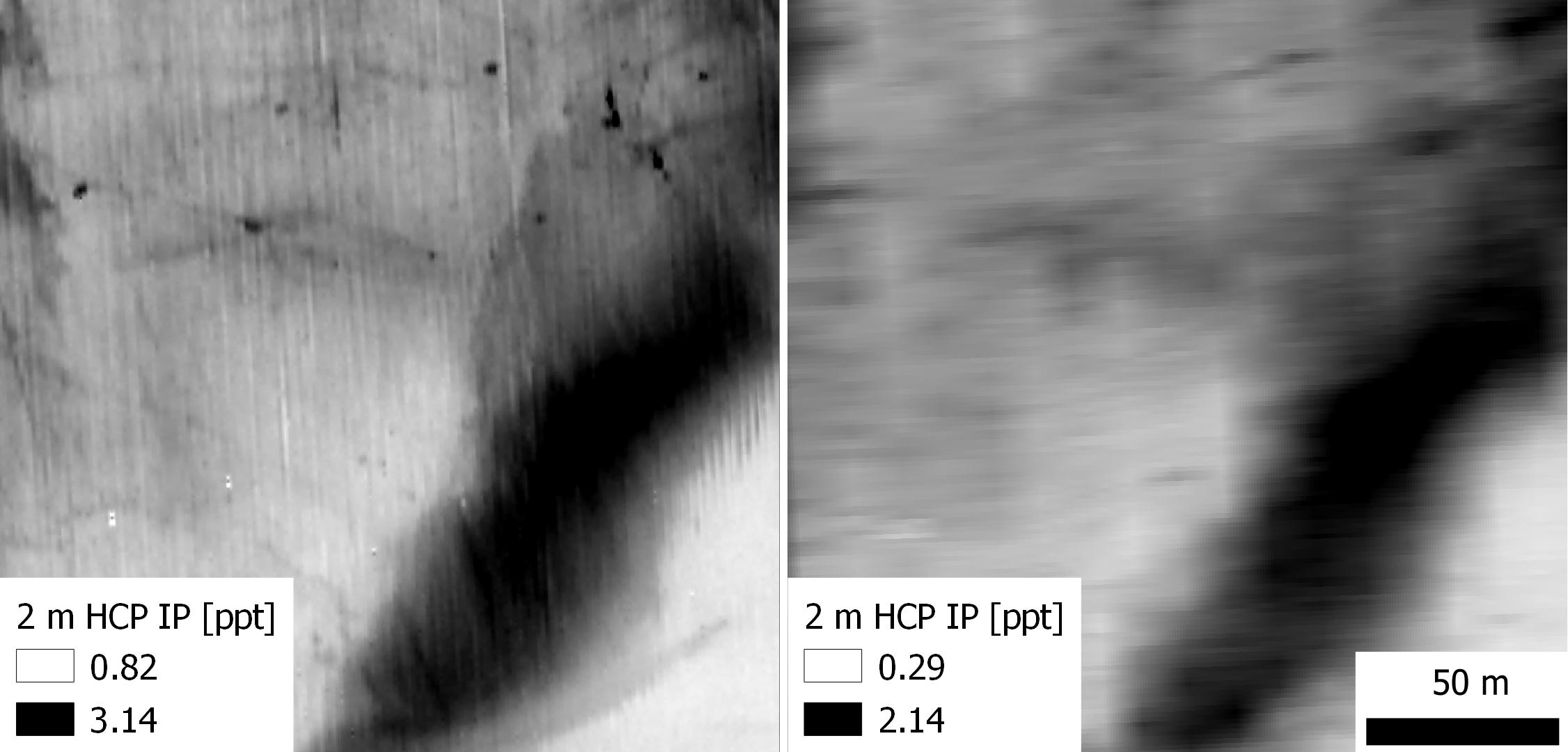
GPS/GNSS systems are commonly installed onto tractors and farm vehicles, but what data on the vehicles operation are collected and stored will vary between models. Sensors and systems that measure or model fuel consumption, wheel slip and tire pressure are increasingly commercially available. There are experimental systems that measure the strain on plough tines or other parts of the system in contact with the soil, which hint at potential future commercial systems. Narrowband and broadband multispectral imaging sensors are available in a growing range of configurations, designed for mounting on UAVs, vehicles, or static installations, capturing images or videos. Geophysical instruments, including those for measuring electrical conductivity through electro-magnetic induction or direct current electrical sensors, ground-penetrating radar, and gamma-ray spectroscopy are all available in configurations designed to be towed or vehicle-mounted. While not towed instruments, handheld XRF (or pXRF) instruments with calibrations available for soil and handheld mid- and near- infrared sensors are relevant developments in soil sensing. For both spectral and geophysical sensors, a key development for the heritage sector has been the design of systems to collect data using arrays of instruments, which allows for higher spatial resolution and the efficient coverage of larger survey areas (Deiana et al. 2018). The growing diversity of towed and mounted sensors is broadly mirrored by the diversity of installed (in situ) sensors.
Installed probes and sensors designed to provide continuous monitoring data, like towed sensors, are not a new technology. Local weather stations, measuring rainfall, air and soil temperature, wind speed and direction, and further parameters such as solar radiation levels, are available in single or networked configurations. These are among the most common in situ sensors in commercial deployments, used to provide high temporal resolution weather data for a local area. Sensors taking readings of soil moisture and temperature at regular intervals have been available for decades. Sensors measuring trace gas elements, water flow rates, and soil moisture and temperature probes are all available, if less widely used in commercial contexts, to provide high temporal resolution monitoring data. IoT sensors ranging from leaf clips (Gupta et al. 2020) to multispectral cameras for monitoring crop development and conditions are appearing alongside more established soil condition monitoring sensors (Roussaki et al. 2022). For both established and newer sensor types, the ability to send data to a cloud platform from a remote location has generated renewed interest (Elijah et al. 2018; Colizzi et al. 2020; Fastellini and Schillaci 2020). The addition of small, low cost solar panels to power sensors and data loggers, which facilitates their use in remote areas for long periods, has also reinvigorated interest in these technologies.
Essentially, while managing multiple installed sensors spread over a large agricultural area was previously impractical because each one would have to be visited and its data offloaded manually, the ability to send sensor data to the cloud over 4G/5G networks without a physical visit to the instrument makes running a network of sensors practical. The emergence of network gateway technologies such as LoRaWan to support the deployment of sensor networks in remote areas with poor cellular network data coverage has further encouraged this trend. LoRaWan networks, for example, are designed to support the transfer of small data packets with low energy costs associated with each transfer, effectively conserving battery life and making prolonged operation off solar panels feasible, allowing operation in remote areas. These networks are suitable for sensors taking readings that are transmitted as single measurements or a small set of measurements. Sensors transmitting larger image datasets have more challenging data transfer requirements, but are also gaining traction, as network coverage improves (Singh and Sobti 2021). While these technologies are not yet fully mature, the present advances are sufficient to encourage IoT sensor development.
Improved network coverage and the emergence of technologies such as LoRaWan are critical infrastructure for moving data from sensors to a platform where end users can access it. The functionality of digital data platforms for storage, analysis and visualisation has also improved significantly. Two key developments should be noted. The first is the emergence of a marketplace for companies to buy hosted space on servers which, to generalise, provide large capacity storage and high data transfer speeds at relatively low costs. The second is the development of APIs as a common infrastructure for programmatically moving data between software systems. The relative ease of managing data storage and programmatic data transfer between software systems is another important enabling technology, which underpins the proliferation of sensor networks for precision agriculture, e.g. Karagiannopoulou et al. 2020.
The final set of enabling technologies is algorithmic. Improvements in computer vision and machine learning together enable more efficient and automated processing of large image datasets. These have encouraged the development of a range of precision agricultural technologies from precision weeders, which use vehicle mounted cameras to automatically detect weeds in ploughed fields (Elstone et al. 2020; Wu et al. 2021), to platforms to detect mowing and ploughing events in Sentinel-1 and Sentinel-2 combined satellite image products (Kanjir et al. 2018). The development of these image processing and analytical systems is, at present, strongly dependent on the creation of relevant image training sets. These training sets are developed as open data products in some cases, and as commercial IP in others. The latter in some cases slows the improvement in image-based systems, as training sets must be reproduced if they are not publicly available, but also encourages development because the training sets are viewed as worthwhile commercial investments (Cravero et al. 2022; Li et al. 2022).
Calibration data libraries are equally important in improving the accuracy of analyses based on sensor data. These calibration data are derived from a range of laboratory analyses of physical samples of soil or plants, depending on their intended application (van der Kruk et al. 2018; Ahmadi et al. 2021; Leenen et al. 2022). They can provide a means to convert from relative to absolute measurements, to link spectral measurements to physical or chemical properties of a material, and to compare between datasets collected on different dates or in different conditions. As with training data, calibration data are produced in both open data and commercial contexts and, again, this mixed situation has both drawbacks and benefits.
The brief review of the technological and policy contexts above highlights several key considerations when planning how to collect and manage data that will be useful across a broad range of land management applications. These can be summarised as:
These considerations are addressed throughout the sections below.
To create interoperable sensing datasets for land management, it is useful to begin by considering what properties of soil-crop systems each domain needs to assess and the range of proxies that can provide useful information about that property. There are two main mechanisms through which an interoperable dataset can be created. The first is through new acquisitions, in which the data collection strategy is designed such that the data can be reused for multiple applications (Elmendorf et al. 2016; Thorpe et al. 2016). The second is through sharing and reprocessing previously collected data that is identified as potentially providing useful information (Zheng et al. 2018). In both cases, it is essential to clearly communicate what information is being sought and what makes a proxy measurement type appropriate.
Mechanisms for ensuring this communication takes place include ranking exercises and the production of scope notes (Levin and Svenningsen 2019; Shen 2021). In ranking exercises, representatives of each domain involved in a project rank the relevance of each data type presented for their work on an agreed scale, allowing a cross-domain ranking of priorities to be created. In scope note-writing exercises, domain experts provide written documentation on the uses of common data types in their domain and read scope notes produced by experts in other domains to produce co-authored documents for each data type. The data description and ranking exercises should increase awareness of related applications of data types and help to identify situations where a data type that is second-best but still usable for a single application may be the best choice overall when considering multiple land management applications. The ipaast-czo project team led a cross-domain prioritisation exercise to identify shared priorities, proxies and suitable sensing instruments for agricultural, environmental and archaeological applications focused on soil systems. This work, carried out through the Soil Health and Soil Heritage Project, highlighted commonalities in properties measured and proxies used across these domains, but significant differences in sampling strategies that must be carefully addressed to create interoperable data.
| Table key: |
| high |
| medium-high |
| medium |
| low |
| uncertain |
| Cross-domain priority | Soil carbon assessment or monitoring | Precision agriculture - management zone creation | Detailed soil properties assessments (nutrients, compaction, etc) | Water monitoring | Buried archaeological feature detection | |
|---|---|---|---|---|---|---|
| medium-high | soil acidity / pH | |||||
| high | soil moisture | |||||
| medium | soil temperature | |||||
| medium | soil compaction | |||||
| low | magnetism | |||||
| medium-high | bulk density | |||||
| high | soil chemistry / nutients | |||||
| uncertain | VOC | |||||
| medium | water table level | |||||
| high | salinity | |||||
| medium | soil CO2 and methane (GHG) | |||||
| high | topography | |||||
| high | organic carbon | |||||
| high | micro-climate |
In the prioritisation and review exercise run through the Soil Health and Soil Heritage collaboration and in the ipaast-czo project's wider reviews, it is evident that there are significant differences in spatial resolution requirements and in sample collection timings. Guides to Good Practice for archaeological geophysical surveys suggest that the sampling rate of the survey should be adjusted to reflect the smallest features it aims to detect. For archaeological surveys, in practice this means most projects will collect data at a sampling spacing of more than 1 point (measurement) per m² (Schmidt et al. 2015). A review of the geophysical survey data holdings of the ADS, which may be taken as broadly representative of practice in the UK, show most projects collect data with a sample spacing ranging between 0.3 to 2m (H. Wright and T. Zoldoske pers. comm.).
In contrast, agricultural geophysical surveys are commonly conducted with the aim of designing management zones. Because management zones have conventionally been delimited at the field or patch scale and are tens to hundreds of square metres, the appropriate sample spacing for geophysical surveys is taken to be on the 10-15m scale (Mulla 2013). This tenfold disparity in spatial resolution is one of the main barriers to interoperable geophysical data for current mainstream agricultural archaeological applications.
Aerial spectral imagery used for feature detection and characterisation in archaeology is typically at a spatial resolution of 20cm or better, with limited use made of satellite imagery with a pixel size of 30-50cm and even more limited use made of 1m+ resolution imagery in the UK and European context (Agapiou 2020). RGB and multispectral imagery from satellite, aircraft and UAV platforms are all in use, with UAVs typically used for smaller areas and aerial and satellite platforms used for extensive mapping projects. The match with imagery typically used in agriculture is closer. For precision agricultural applications, the 5m resolution data made freely available through the Sentinel satellite missions is widely used. Products derived from commercially available multispectral imagery with a resolution between 30cm and 1.5m are also relatively widely in use, as are high-resolution image sets collected using UAVs (von Hebel et al. 2021).
It's worth emphasising that the relatively coarse spatial resolution used in precision agriculture projects is largely driven by two factors: costs, as higher resolution data takes longer to collect, and the configuration of equipment, particularly vehicles, which were designed and purchased for a model of farming that did not envision management at an individual plant scale, and which are intended to be medium term investments. Consequently, while archaeological datasets might provide more detailed mapping information on soils, the detail might have limited practical application because farming equipment 'locks in' the current level of detail.
In parallel, agricultural geophysical survey data are of limited use for feature detection and characterisation, which is the most common aim of archaeological surveys. While agricultural geophysical datasets could have applications in monitoring the conditions of a known set of archaeological features or in mapping preservation potential (for instance in deeply stratified sedimentation areas (e.g., Verhegge et al. 2016; Deschodt et al. 2021), these are not typical project aims. Here costs and management models are key factors. Data for monitoring of conditions at known sites would need to be purchased or licensed from agricultural providers. Current workflows for site visits and monitoring do not usually include geophysical or spectral survey, so while relevant data might be available, it might be considered unnecessary for current monitoring strategies. As precision agriculture requires more detailed soil data to support more targeted management, and as heritage management pays increasing attention to the impacts of environmental change, the gap in resolution may reduce, but this is not an immediate prospect.
In addition to the critical question of spatial resolution, gaps in coverage present another challenge. While satellite data are relatively uniform globally and national datasets with regularly updated aerial imagery and terrain models derived from lidar data provide broadly consistent information, precision agricultural, environmental and archaeological data are often collected on a per project basis, resulting in variability in sampling strategies and data resolution and patchy coverage. Gaps in data coverage and the lack of uniformity in data present significant challenges for analysis and comparability. Variability in data acquisition timing, discussed below, compounds the challenges posed by non-uniform coverage and spatial sampling.
When a dataset is collected will impact on its usefulness for different land management applications. For precision agricultural applications where the conditions in a developing crop act as a proxy for the effectiveness of management interventions, soil properties, or another factor that affects their growth, data collection will be timed to target a particular phenological stage. For archaeological applications where the detection of 'cropmarks' is the aim, data collection will be timed to maximise variability in the development of a theoretically uniformly planted crop, generally achieved by targeting periods with maximum environmental stress (Agapiou et al. 2013).
For soil mapping applications, access during crop-off periods is often a primary pragmatic consideration, as is the avoidance of environmental conditions such as very wet or dry conditions, which reduce the sensitivity of instruments. The requirements for timings for soil mapping projects are more likely to be compatible than those where crop development is a critical factor. The integration of datasets acquired on different dates requires careful attention, and is more feasible if conditions at the time of acquisition are well documented. This can be accomplished through data-collector provided documentation or through local weather station data, including that generated by micro-meteorological stations.
The frequency with which a sensing dataset is updated is an important consideration. High spatial resolution sensing datasets in archaeology are most commonly collected as a once-off mapping exercise, intended for feature discovery rather than ongoing monitoring. In contrast, in precision agriculture ongoing monitoring of conditions is a priority, as this information is used to adjust management strategies. Data may be updated several times across a growing season to see impacts of irrigation or fertiliser application strategies, annually to adjust management zones, or on a five-year cycle to assess the impacts of management in aggregate on soil nutrients (Mishra 2022).
The different sampling strategies used in land management can be conceived of as mapping, monitoring and intervention-orientated strategies. Mapping strategies prioritise high spatial resolution and large area coverage over frequently repeated data collection, while monitoring strategies invert these priorities. Intervention-orientated strategies take a flexible approach, collecting the data needed to inform a specific management decision, for example the creation of agricultural management zones.
Developing strategies that combine mapping and monitoring approaches and integrate infrequently collected high spatial resolution data with frequently updated medium spatial resolution data may enable the creation of datasets that are useful for a broader range of applications. High spatial resolution one-time collection datasets can provide baseline data for spatially sparse but frequently collected data, enabling better ongoing condition monitoring. Spatially sparse data on soil characteristics generated through precision agricultural work may not be suitable for feature detection but may inform heritage management decisions. Up to date precision agricultural sensing data that indicate changes in land management may likewise be useful for heritage management condition monitoring. In parallel, heritage management condition monitoring data collected over longer timescales may provide important contexts for assessing the overall impacts of more recent agricultural management strategies.
Beyond considering the utility of specific combined sampling strategies, the current technological and policy context suggests a more fundamental shift in how we collect and deploy sensing data for land management. Some land management aims continue to benefit significantly from extensive uniform sensing data. Flood risk mapping is a relevant example, because computational models of water flow across the landscape need to be complete and consistent over extensive areas to produce accurate local predictions and can be sensitive to small variations in the terrain models used. Other land management aims may be achievable with data acquired using a range of sensors and less consistent sampling strategies.
For example, managers responsible for mitigating soil acidification in Scotland could use the national topsoil pH dataset produced by JHI (Thematic Soil Maps - Topsoil median pH - Natural Asset Register Data Portal) to identify areas to prioritise for monitoring and intervention. Monitoring and managing soil acidification are important for agricultural, environmental and heritage applications. This dataset is currently produced using a protocol based on physical soil sampling and chemical analysis, with measurements extrapolated from sample locations using a statistical model that incorporates complementary data and attempts to correct for known biases in the dataset. If data on topsoil pH produced using different protocols, for example precision agricultural data from soil samples collected privately by individual land owners or measurements derived from gamma ray spectroscopy surveys run commercially, were integrated into the model, it might still be reasonable to produce a prioritisation for monitoring given the existing variability in the dataset. The national topsoil pH dataset also relies on maps of soil types as a key component of its modelling. Here archaeological data could be integrated, incorporating information on soils derived from archaeological geophysical surveys and from development-led archaeology activities such as watching briefs, adding samples that would make local improvements to the soil maps underpinning the modelled pH data. Producing a new model based on mixed data would require collaborative research and careful calibration and modelling, but could provide an alternative approach to extensive surveys with uniform protocols.
Broadly, interoperable sensing data for heritage, environmental and agricultural applications can be created through a mixture of extensive sensing data acquisitions, using sensors with broadly uniform characteristics, and temporal and spatial sampling following a centrally organised model, combined with precision agricultural sensing data acquired using more diverse sensor types and spatial and temporal sampling strategies. The latter model is aligned with linked data approaches. Because consistent data has been considered a necessity, or at least the gold standard, potential data sources have been historically excluded, resulting in spatially and temporally sparse datasets on soil systems. Pragmatically, including a more diverse range of data sources enables the production of more spatially detailed and frequently updated datasets which, while not gold standard, may be usefully applied in land management.
The availability of new datasets has most impact if it prompts rethinking of current working practices. Here we provide a theoretical scenario in which Sentinel-1 and Sentinel-2 combined data derivatives are integrated into a heritage monitoring workflow as an example of reuse of data developed for agricultural monitoring positively impacting heritage monitoring.
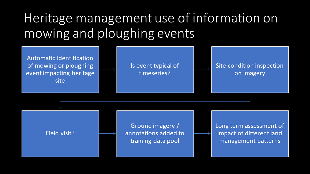
Ongoing condition monitoring at heritage sites is a long-standing challenge because individually checking conditions at locations of buried and surface features located across an extensive area is resource intensive. The mowing and ploughing event layers derived from Sentinel-1 and Sentinel-2 data were developed by the Sen4CAP project with the aim of supporting CAP compliance monitoring. These event layers use time series of combined S-1 and S-2 imagery together with land parcel identification system (LPIS) information that delimits parcels and calibration data in order to identify mowing and ploughing events. These data layers are produced at national or regional scales by government agencies with a remit for land management (Kanjir et al. 2018; Schulz et al. 2021; De Vroey et al. 2022). While not developed with heritage management applications in mind, these data have reuse potential within condition monitoring workflows.
For a heritage manager responsible for monitoring the conditions of sites in agricultural land, it is useful to know when land management practices change or when exceptional management events occur. While individual mowing and ploughing events may not be relevant, events that are not typical of a time series at a heritage site can be used to signal the need for an assessment. Figure 3 illustrates a workflow for monitoring that integrates this data layer. While sentinel data are widely used in land management in Europe, the mowing and ploughing event layer, to our knowledge, has very limited uptake for heritage management. This simple example of cross-domain reuse of a sensing data product illustrates how archaeology and heritage management can benefit from integrating data sources developed for agricultural applications, leveraging developments emerging from precision agriculture.
While the emphasis in commercial precision agriculture has been on producing new data, as noted above, it has driven broader development in data infrastructures for agriculture that support data aggregation, harmonisation, exchange, and modelling – largely through a series of EU- and NGO-funded projects. These infrastructures improve capacity for incorporating pre-existing (legacy) data into land management workflows. However, to make pre-existing sensing data useful, a range of standard FAIR data and cross-domain translation issues must be addressed. The baseline work needed to align terminology to enable data discovery, adjust data collection structures, and provide documentation of intended uses and limitations, is outlined below.
When working with digital data, discoverability, or findability, as envisaged in FAIR data frameworks, is closely connected to how search systems work. Whether using search engines driven by natural language, faceted searches, or filtering on a structured list of terms, the language used to describe a dataset is a primary factor in whether or not it is returned to a user. For sensing data, the language used to describe a dataset is particularly important because the actual data are often abstract, either a collection of images or numeric and coded data. Consequently, search engines can't use the contents of datasets to match them with queries. The vocabulary used to describe a dataset will, often unintentionally, reflect the background and language used by the discipline of the person creating its metadata and keywords. In parallel, the terms used to search are often discipline specific. The combined use of discipline-specific language in descriptions and vocabularies is inevitably a barrier to cross-disciplinary data discovery.
The keywords used to tag heritage data, selected from the Getty AAT by metadata authors, provide an example of the impacts of the use of domain specific terms. Remote sensing datasets contributed to ARIADNE, a major EU data aggregation portal for the heritage and archaeology domains, are usually tagged with the survey method used, e.g. 'geophysical survey' and a second term that describes the kind of features identified, e.g. 'cemetery' or 'settlement'. For geophysical surveys, the term describing the method enables cross-domain discoverability, but the inclusion of further terms including 'Landscapes (environments), Soil, Geomagnetism, and Magnetic Surveying' would all improve cross-domain data discoverability, as these terms are widely used in data repositories used in environmental and agricultural communities. For sites identified as cropmarks in aerial imagery, the barriers to discoverability are greater because the tag 'cropmark' is used and this term's use is fairly exclusive to archaeology and heritage management. The use of terms such as 'Landscapes (environments) and aerial surveying' again would improve discoverability by a wider range of potential data users.
By selecting keywords that are used in multiple domains involved in land management, overall data discoverability can be improved, leading to more cross-domain reuse of sensing data. The ipaast-czo project has provided recommendations for the use of Getty AAT vocabulary terms to tag common types of sensing data created through archaeological and heritage management projects (Opitz 2022).
Data collected for use in one domain may require reorganisation to be useful for answering questions relevant in other land management domains. This reorganisation may require the inclusion of available complementary data or the creation of new metadata. The restructuring of data on cropmarks illustrates how a dataset collected for a domain-specific application in heritage could be made useful for applications in the agricultural and environment domains. For heritage management applications, the current data model is structured around individual sites where a cropmark has been identified, with information on any subsequent observations noted as secondary information, held under 'events' in a UK heritage data record. In this data model, the frequency at which a cropmark appears, when it was first and last observed, and the crop in which it appears are all considered secondary to the existence of the feature interpreted on the basis of the cropmark's appearance and the interpretation of the type and, ideally, dating of the feature recorded. Cropmarks are broadly recognised in archaeology and heritage management as being caused by local variations in crop development that result from the developing crops' reaction to differences in soil properties which are, in turn, affected by weather and other contextual factors.
For agricultural applications, in principle cropmarks can serve as source of information on how developing crops react to environmental conditions and as a source of information on the consistency of production and robustness to environmental stress of a part of the landscape. However, to facilitate addressing these questions, information on when observations of cropmarks occurred, which are usually held in related 'observation events' information, need to be brought into the primary dataset Further, dates where a cropmark location was checked but no observation was made need to be included in the data model. At present, there is information on when surveys took place, but this is held separately to information on observations. Connecting these data would produce a more interoperable cropmark record. Proposals for a structure for cropmark records to maximise its interoperability for land management applications have been developed by the ipaast-czo project (PDF).
While metadata typically describes the contents and structure of a dataset, the intended applications and limitations on its use are less consistently included in this documentation. The range of envisaged applications of the data and any caveats based on how the dataset was created are instead either documented in domain-specific literature or not formally codified. Transmitting this information through disciplinary literature or via received practice within a specialised research community is a functional approach when the user community has a coherent background and exposure to broadly similar training. As land management, envisaged through the lens of ecosystem services, encompasses a growing number of disciplines and specialisms, formalising these explanations becomes a useful mechanism for enabling the use of shared data sources.
While it is possible for the group producing a data source to take sole responsibility for producing an explanation of its scope of application, there are benefits to producing these documents through cross-disciplinary collaborations. Collaborative authorship of scope of application documents promotes conversations between specialists, prompting them to clearly explain assumptions implicit in their practice, and may bring to light new applications for data, lead to the questioning of assumptions about data interpretation, and generate broader collaborations. Examples of scope of application documents intentionally written for cross-domain land management audiences have been developed through the ipaast-czo project (https://doi.org/10.5281/zenodo.7472497)
As with scope of application documentation, workflow documentation captures knowledge and practices that are implicit or transmitted informally through research networks. Formalising workflow documentation improves the interoperability of data derivatives by making clear the processing steps and configuration choices used when generating sensing data products. The ipaast project has developed high level templates for sensing data workflow documentation examples for remote and near-surface sensing data acquisition, mapped to the ARIADNE application profile, providing a practical example of how these process metadata could be provided through currently active data exchange platforms (Opitz 2022).
Remote and near surface sensing data are widely used in archaeology and heritage management for feature discovery. To a lesser extent, they are used for change detection and monitoring within heritage management programmes and as an input to predictive modelling or as a data layer in desktop-based planning in development-led projects. While some nationally or regionally acquired data sources are in use, much data are acquired specifically for archaeological use because of the very high spatial resolution required for feature detection. Consequently, the coverage of available data is limited and the range of instruments used is relatively narrow.
As the practice of precision agriculture produces an increasing quantity and variety of data, there is an opportunity to identify adaptations and reuses of these data for heritage applications, improving the coverage of data useful for archaeological and heritage management work and identifying new applications for these data. In parallel, there are opportunities for coordinated data collections in the context of integrated land management, improving efficiency by collecting data once which can serve multiple purposes. Equally there is potential for enhancing analysis by bringing together perspectives from multiple related domains to model long-term processes in anthropogenic soil systems. The reviews and case studies presented here outline technological, practice-based and conceptual points at which archaeological and precision agricultural sensing intersect, enabling the tighter integration of archaeology and cultural heritage management into sustainable agricultural land management and adding value to precision agricultural data through shared data and workflows. The challenge, not to be underestimated in its scale, lies in creating meaningful connections, motivating collaborative work with sensing data, and developing useful integrations of the knowledge produced by different domains at these points of intersection
The reviews and case studies presented were developed through the ipaast-czo project, which aims to improve the interoperability of remote and near-surface sensing data to inform and enable integrated land management practices. The ipaast-czo project is supported by funding from the British Academy, award number KF5210407, for the project 'Developing a method for studying the Critical Zone: Connecting Archaeological and Precision Agricultural approaches to agrarian landscapes by making their advanced sensing data interoperable'.
The review of instrumentation was undertaken through the Soil Health and Soil Heritage Collaboration, funded by the University of Glasgow through a NERC Discipline Hopping Award.
Internet Archaeology is an open access journal based in the Department of Archaeology, University of York. Except where otherwise noted, content from this work may be used under the terms of the Creative Commons Attribution 3.0 (CC BY) Unported licence, which permits unrestricted use, distribution, and reproduction in any medium, provided that attribution to the author(s), the title of the work, the Internet Archaeology journal and the relevant URL/DOI are given.
Terms and Conditions | Legal Statements | Privacy Policy | Cookies Policy | Citing Internet Archaeology
Internet Archaeology content is preserved for the long term with the Archaeology Data Service (ROR). Help sustain and support open access publication by donating to our Open Access Archaeology Fund.
 Home
Home