Cite this as: Zirne, S. and Lusena, E. 2023 Preservation of Archaeological and Natural Values. A Case Study of the North-Western part of Latvia, Internet Archaeology 62. https://doi.org/10.11141/ia.62.14
Latvia is a country of the Baltic region, which occupies 64,589km² on the eastern coast of the Baltic Sea and the Gulf of Riga. In this relatively small area, there are 690 specially protected nature territories and almost 2500 state-protected archaeological monuments. The location of archaeological monuments in nature protected areas to a certain extent creates multifunctional protected environments, the preservation of which requires a special approach, respecting all their qualities and values.
The north-western part of Latvia is a culturally and historically important coastal region, where there are diverse protected natural areas, a unique coastal landscape, and significant archaeological sites (Figure 1). At the same time, it is a territory where the cultures of two ethno-linguistic groups – Baltic Finns and Balts or Baltic people – have historically interacted for centuries. Traditionally, this territory is called Kurzeme, which in prehistoric times was inhabited by one of the ethnic groups of the Balts – Curonians (Kurši). Northern Kurzeme is a region also inhabited by Livonians (Livs) who belong to the Baltic Finns. According to written sources and archaeological evidence, in this region Livonians lived together with the Curonians, who ruled over most of historic Kurzeme in the 12th-13th centuries.
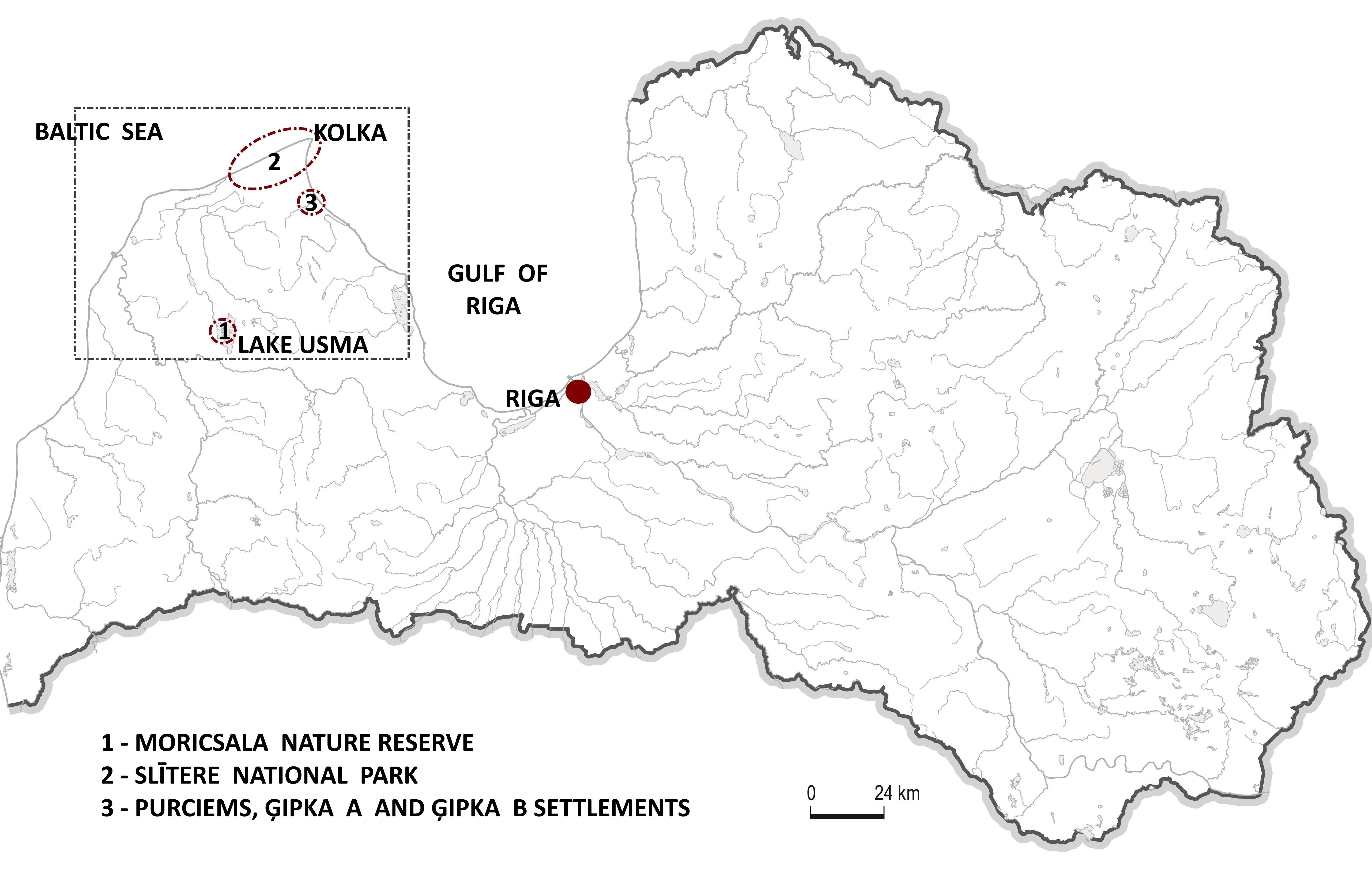
Such a set of natural, historical, and cultural values in the region creates a special cultural and historical environment. In the north-western part of Latvia, there are specially protected nature territories of national significance: Moricsala Nature Reserve and Slītere National Park, as well as several archaeological monuments, i.e. Stone Age settlements. The protection and preservation of archaeological monuments largely depends on the rules for the management and use of nature territories, therefore a unified approach at a national level is necessary, which would promote the formation of a special cultural and historical environment.
Environmental protection policy in Latvia is the responsibility of the Ministry of Environmental Protection and Regional Development of the Republic of Latvia. One of the goals of environmental protection policy is related to nature protection and management of specially protected nature territories. Such territories have general regulations defined in the Law 'On Specially Protected Nature Territories' (1993). According to this Law, such territories are created for the protection and preservation of natural diversity, ensuring supervision of scientific research and environmental monitoring, as well as for the preservation of objects important for public recreation, education, and training. Specially protected nature territories are classified as strict nature reserves, national parks, biosphere reserves, nature parks, natural monuments, nature reserves, protected marine areas, and protected landscape areas (1993 section 2). In addition to protected natural areas, according to the law, there may also be separate protected natural monuments. They are separate, isolated natural formations: protected trees, plantations, avenues, geological and geomorphological natural monuments, and other natural rarities having scientific, cultural, and historical, aesthetic, or ecological value (1993 section 6). By 1 January 2020, 10,543 large trees and 117 large stones were identified and registered, resulting in a significant increase in the total number of individual natural monuments, reaching 10,990 (Nature Conservation Agency data).
There are several institutions under the supervision of the Ministry of Environmental Protection and Regional Development, of which the Nature Conservation Agency (NCA) ensures the implementation of a unified nature protection policy. The agency's responsibilities include the management of all protected natural areas in Latvia, including the management of scientific research, as well as the management of nature protection planning and the promotion of plans in these areas. According to the Law 'On Specially Protected Natural Territories', in order to coordinate environmental protection, use of natural resources and the interests of regional sustainable development, as well as to ensure the preservation of the natural value of the territory, a protection plan can be developed for such areas. The plan should include scientific information about the protected area, the justification for functional zoning, and determine unified management measures for the whole of the territory (1993 section 18). Special laws have been developed for particularly important protected natural areas, which determine the rules for their protection and management. These plans also include sections on cultural and historical values but are sometimes of a purely formal nature.
There are 2470 listed archaeological sites in Latvia. The Ministry of Culture of the Republic of Latvia is responsible for the preservation and protection of cultural monuments, including archaeological sites. The National Heritage Board, which is under the supervision of the Minister of Culture, implements public administration in this field. Many archaeological monuments are located in specially protected natural territories. Sometimes an individual natural monument, such as a tree or stone, is also an archaeological monument; thus it has dual protection status. Most often, it refers to ancient cult sites, such as trees, stones, caves, springs, the sacred meaning of which is confirmed by written sources or archaeological investigations.
The preservation and protection of cultural monuments is regulated by the Law 'On Protection of Cultural Monuments' (1992). According to this law, state-protected cultural monuments in Latvia can also be types of immovable cultural monuments, such as complex objects, archaeological sites, cultural-historical landscapes and historical places and territories (1992 section 2). Considering that the preservation of natural and cultural values in Latvia is the responsibility of institutions subordinate to two different ministries, it is important to find a common model of co-operation between them at all levels of management.
Special regulations have been developed for the protection and management of the Moricsala Nature Reserve and Slītere National Park.
North Kurzeme is the least archaeologically researched region in Latvia. There are few known Stone Age monuments there, and little research has been done, although rich finds have been obtained. One of these regions surrounds Lake Usma, one of the largest lakes in Latvia. It has several islands, and its coastline is made up of bays, capes and headlands, which have been given interesting local names. For example, Elka (Idol) Cape, where according to written sources from the middle of the 13th century, a village was located (Archive of National Heritage Board of Republic of Latvia. No. 39.189-7I). There is also an Elka (Idol) linden, which was associated with sacred activities. There are oral traditions that connect this place with ancient sacredness. These are folk stories about images of idols, placed on linden branches, offerings made to the ancient gods near the linden tree, and the meetings held there.
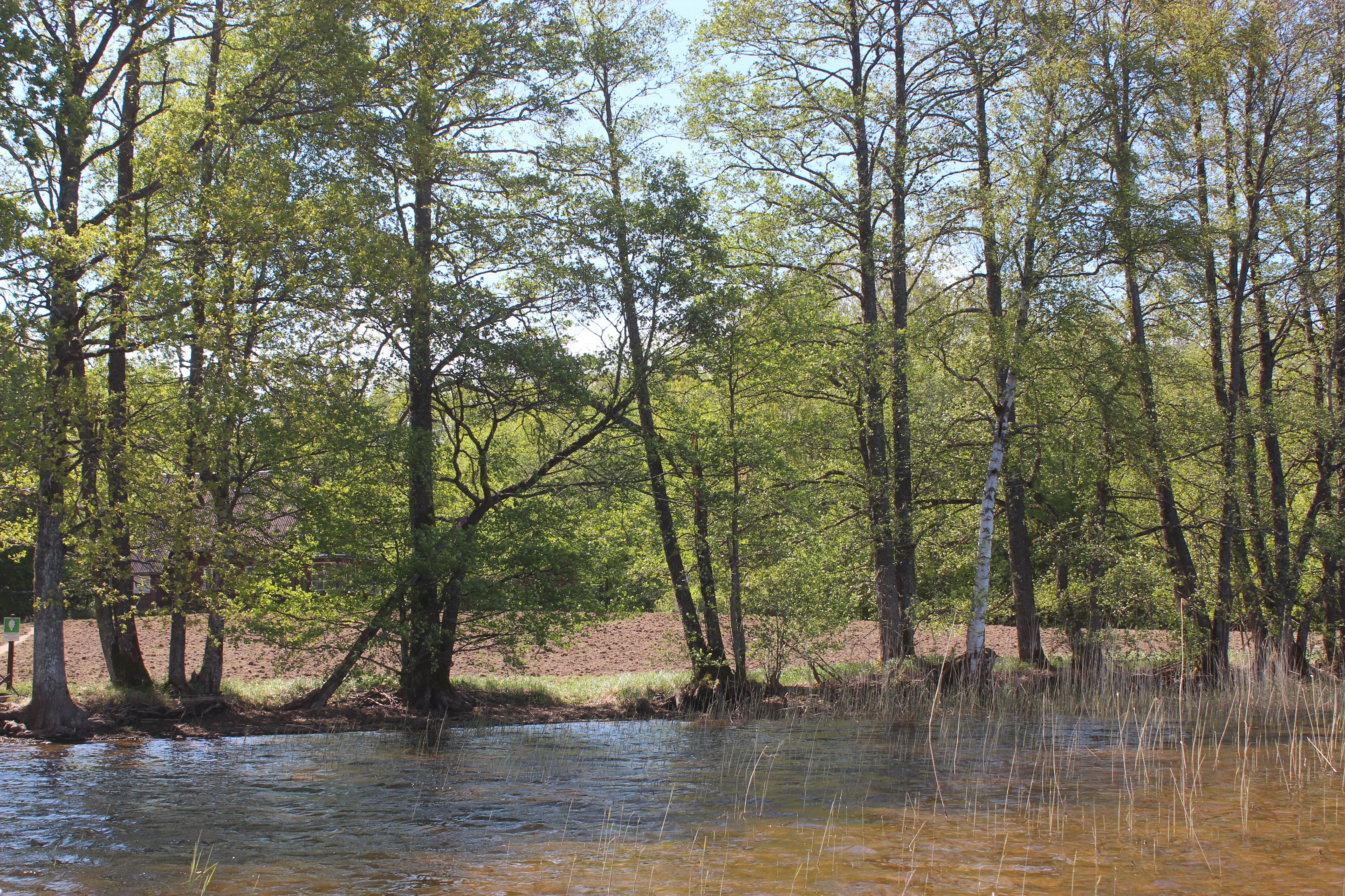
Historic Moricsala is an island within Lake Usma and owes its name to the then Duke of Courland, Moritz of Saxony, who once hid there. Moricsala is the oldest nature reserve in Latvia, founded in 1912. According to the 'Moricsala Nature Reserve Law', it is a specially protected nature territory of national significance. The reserve was created to preserve undisturbed historically formed natural ecosystems and to study the processes taking place in them, as well as to ensure the protection of endangered and rare plants, mushrooms, lichens and animals (2000 section 1, 2). The territory of Moricsala Nature Reserve (Figure 1:1) includes Moricsala (83 ha), Big Alder Island (33 ha) and LuziÄ·ērte Bay of Lake Usma (702 ha). It consists of boreal, mixed broad-leaf and oak old-growth forest as well as swamps. Moricsala has a very rich flora and fauna: 409 species of vascular plants, 157 species of mosses, 338 species of fungi, 82 species of lichens, 320 species of butterflies and more than 100 species that are considered rare and protected not only in Latvia, but also in many other European countries (see Nature Conservation Agency data). It is a peculiar, rare primeval forest landscape. It is a strict nature reserve, so entry into the reserve is prohibited, except for scientific purposes. The only ones who do not follow these rules are wild animals. On the island, there is also an archaeological monument – a Stone Age settlement (Figure 2). A few years ago, wild boars dug a shallow shelter covering a large area, which caused damage both to the archaeological monument and to the natural values. Specialists of the nature reserve decided to level the topsoil and allow the natural meadow to regenerate in this area. This process will take several years. The protection of the settlement mainly relies on natural conditions, as nature protection regulations do not allow human activity here.
In 1905, a forester's house, the first and only house, was built in Moricsala. Until then, the island was not inhabited. The first stray finds (a stone axe and a flint knife) from Moricsala were in 1926. In later years, Stone Age artefacts were also found in this area, while many Stone Age artefacts have also been found near the coasts of Lake Usma. Near the coast of Lake Usma, many Stone Age artefacts, especially different types of bone spearheads and stone axes, have been discovered.
In 1978, archaeologist Ēvalds Mugurēvičs during archaeological research in the Kurzeme, surveyed the site on Moricsala. He opened ten trial trenches and found in three a 0.30–0.50cm thick culture layer with charcoal (Zagorska 2000 110). Mugurēvičs interpreted the results as traces of a Stone Age settlement. During the archaeological research in the vicinity of Lake Usma in 2003, small test excavations were carried out in the Moricsala settlement by Ilga Zagorska (Zagorska 2004 17). Flint blades, cores and some flint tools were found in the backyard garden. The findings undoubtedly show that there once was a Mesolithic settlement.
Another Stone Age to Middle Mesolithic settlement is located around 2km north-west from Moricsala, on the banks of the Engure River, where it flows out of Lake Usma. In 1983, a small archaeological test excavation was carried out (Zagorska 2000 111–18). Current archaeological research indicates that the coast of Lake Usma and its immediate surroundings is a promising area for further studies.
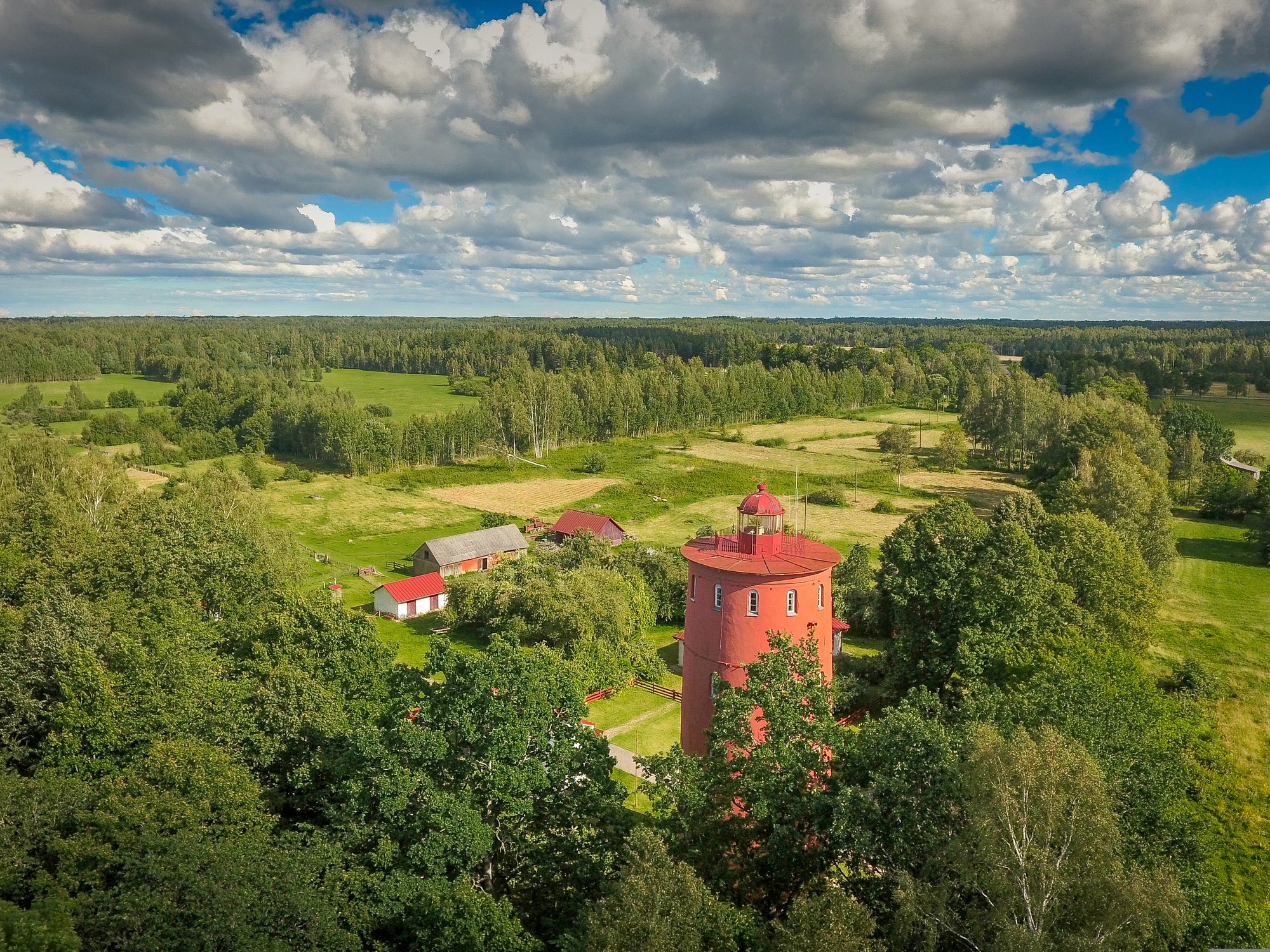
Slītere National Park was historically created as 'Slītere Natural Monument' in 1923 as an area of protected natural beauty covering some 1100 ha (Figure 1:2). The National Park was officially established in 2000 by a special law. It includes a 30–50m high level of the ancient shore of the Baltic Ice Lake, called Blue Hills, a species-rich natural broadleaf forest, and a unique complex of dunes several kilometres long (kangari in Latvian) intersected with depressions (vigas) featuring inter-dune bogs. The Blue Hills are Latvia's oldest sediment cliffs visible above ground. Their total length is 20km, approximately 9km of which are in the territory of the Slītere National Park. The Blue Hills show the historical development of the Baltic Sea. On the edge of a steep slope lies the second oldest navigation building in Latvia – Slītere lighthouse, built in the 19th century (Figure 3). The Slītere lighthouse is special because of its location, 5.3km from the coast. The lighthouse tower is 26m high, while the rotary light stands 102.2m above sea level. Today, the lighthouse is a state-protected cultural monument and a popular tourist destination. The five floors of the lighthouse exhibit educational information about Slītere National Park, coastal nature, other lighthouses in Latvia, and the history of the Livonians. At the foot of the Blue Hills, there is a plain with natural wet forests, and the only known high-altitude sea swamp in Latvia – Bažu swamp, with rare biotopes. An integral part of the Slītere National Park is the seaside, with sandy beach and dunes, dry pine forests of dunes, as well as coastal waters. Only a few archaeological sites have been discovered so far; however, considering the formation processes and historical development of this territory, it has a high potential for future research.
In 2015, a new Slītere National Park Law was adopted with the aim of preserving the coastal landscape of the Northern Kurzeme: its natural macro-scale terrain, cultural and historical values, particular characteristics of the environment, typical and specially protected species, their habitats, and specially protected biotopes that are characteristic of the territory of the National Park, and also to ensure sustainable development of the territory by coordinating the protection and preservation of natural, cultural and historical values with the economic development of the territory. According to the Slītere National Park Law, the area of the park currently includes 16,360ha of land and 10,130ha of sea 2015 section 2).
The territory of the park is divided into five functional zones with different maintenance regimes such as the strict regime, regulated regime, nature reserve territories, landscape protection zone and neutral zone, where coastal villages have historically formed. The strict regime zone is designed to preserve areas untouched by human activity and little modified, where the development of natural processes is not disturbed. The land of the strict regime zone constitutes State property (2015 section 4, 5). Determining such a strict regime zone in a protected natural area also ensures the preservation of the archaeological sites in it. The territory of the regulated regime was created to preserve Bažu swamp, and most of this territory is state property (2015 section 6). The nature reserve zone has been established to protect lightly modified ecosystems and rare and disappearing species and biotopes (2015 section 7). If the territories and zones thus described are determined for the protection of relatively specific natural values, then the landscape protection zone includes wider environmental preservation. The landscape protection zone has been established for preserving the landscape and biological diversity of coastal forests and protection of the cultural environment characteristic of Northern Kurzeme, as well as to ensure the preservation of an environment suitable for recreation and tourism and the use of nature-friendly management methods (2015 section 8). The landscape of the sea-coast is characterised by white sand beaches, sandy dunes, dune forests, and historically established small fishing villages with their typical building layout. In North Kurzeme, the sea-coast landscape is evidence of a set of cultural and historical values located on the coast of the Baltic Sea and the Gulf of Riga with historical sites, the ethnic culture space of the Livonians, coastal lifestyle heritage, symbolic significations, and unique natural values, as well as footprints of Latvia's difficult history of the 20th century. The seacoast landscape of Latvia is included in Latvia's Cultural Canon which does not impose legal obligations, but highlights the value of the landscape.
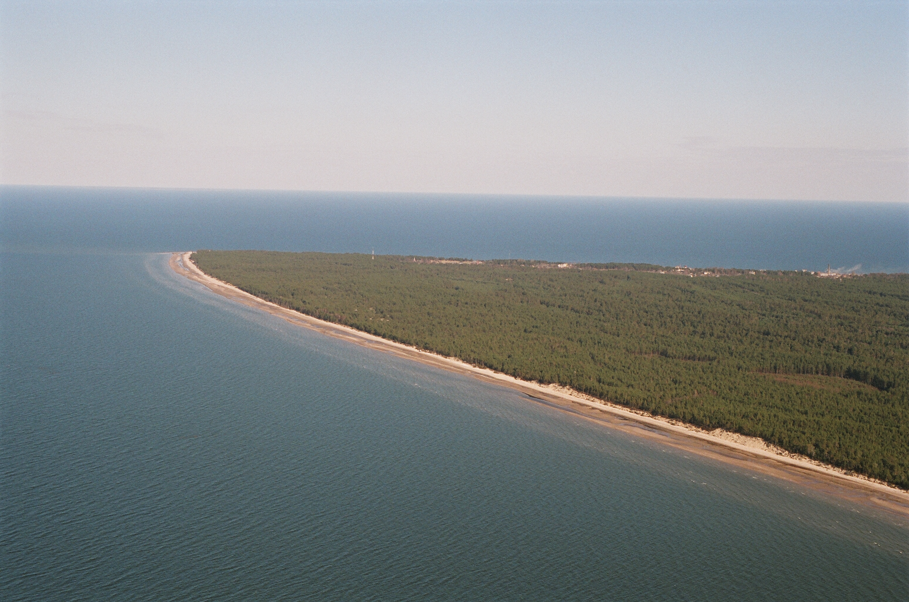
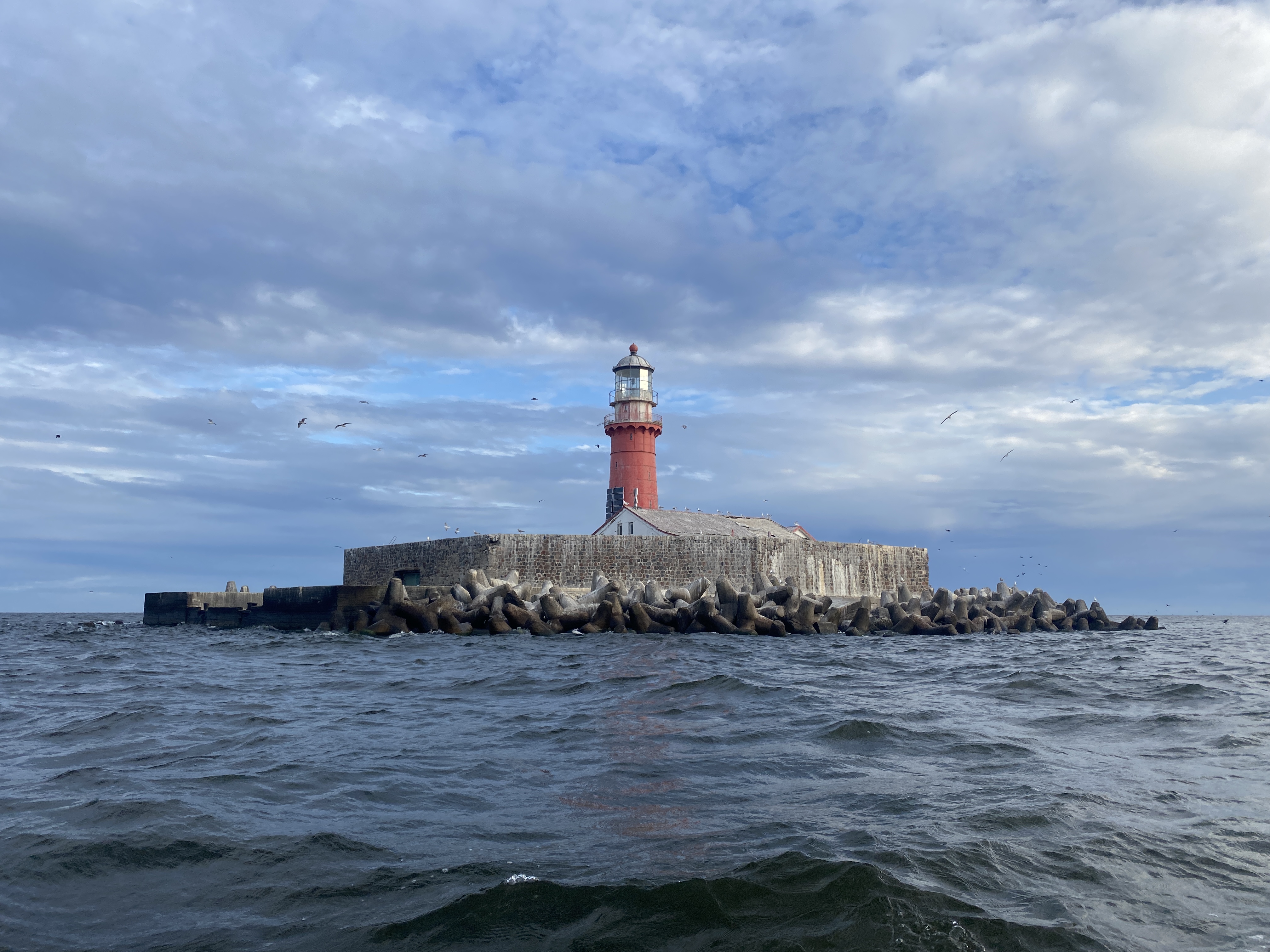
One of the most scenically expressive places in the Slītere National Park is Cape Kolka – the northernmost point of the Kurzeme (Courland) peninsula (Figure 4). Its ancient name, Domesnes, was first mentioned on the Mervalla Rune Stone in Sweden around 1040. The shelf of Cape Kolka stretches into the sea for about 6km. This is the most distinct cape in Latvia, where the waters of the Baltic Sea and the Gulf of Riga meet. During storms, the waves can be up to 7m high. The cape extends to the Kolka lighthouse, which is located about 5km from the coast on an artificial island created for this purpose in the 19th century (Figure 5). The Kolka lighthouse was put into operation in 1884 and modernised in the 1960s. Since 1979, it has been operating in an automatic mode, without service personnel. The Kolka lighthouse complex with the historical staff buildings and the island's defence structure is a state-protected industrial monument.
The landscape protection zone of Slītere National Park includes neutral regime territories. The neutral zone is designed to promote the sustainable development of populated areas, as well as to ensure the maintenance and development of transport infrastructure facilities (2015 section 9). The requirements for the protection of cultural monuments and the environment in these territories are mainly determined by the regulatory framework for the preservation of cultural heritage, as nature protection regulations are often not enough to balance territorial development plans. The main group of archaeological monuments in these territories are ancient cemeteries connected with the origins of coastal villages.
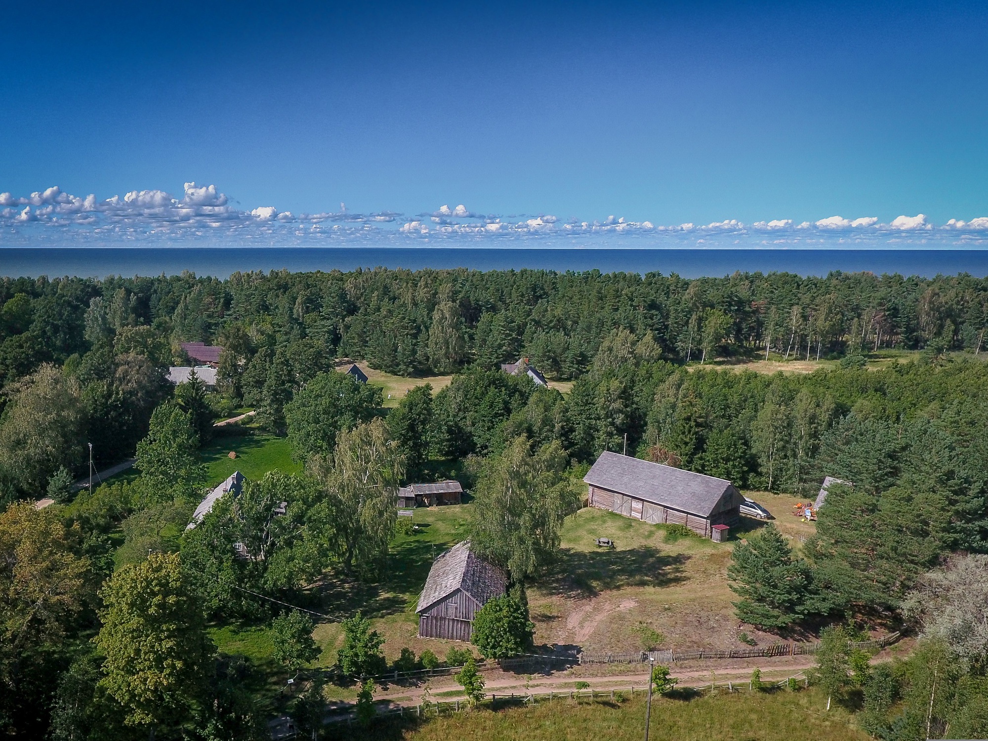
In 2003, the status of the 'The Livonian Coast' as a protected cultural and historical territory of the state ended. This territory involved a series of shoreline villages along the shores of the Baltic Sea and the Gulf of Rīga (Figure 6). Historically, Livonian villages on the coast formed after the end of the 16th century and their culture flourished until World War I. After that war, Livonians gradually integrated into the Latvian culture, but the most radical changes in their traditional lifestyle and culture took place after World War II, during the Soviet occupation. Today, only a small number of Livonian descendants maintain, preserve and promote their cultural heritage. The Livonian language and cultural values are part of Latvia's national cultural heritage, and traditional Livonian culture is part of Latvia's Cultural Canon.
In the territory to the south, east of the Slītere National Park, there is another culturally and historically important landscape area, which includes three white dune exposures and several Stone Age settlements.
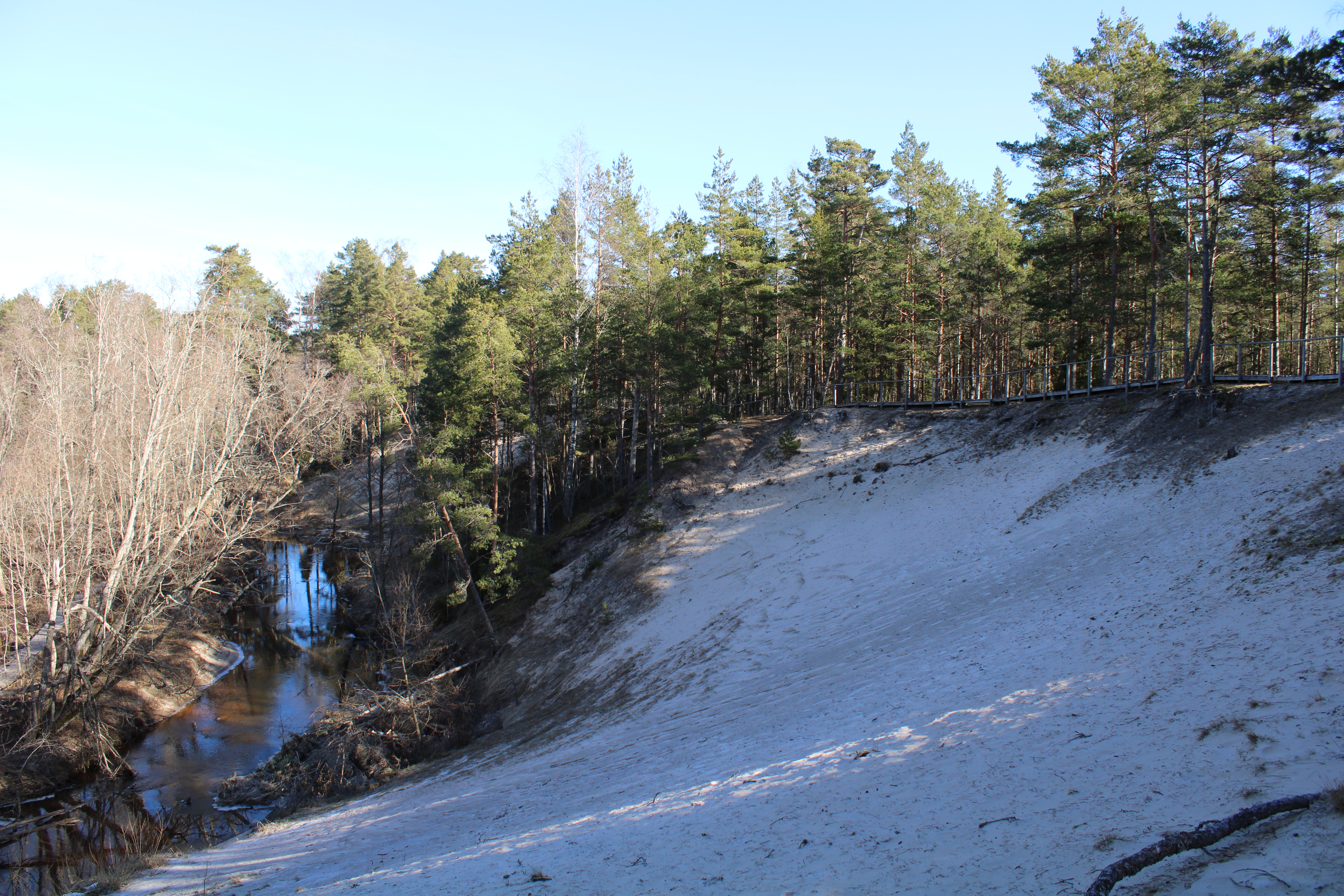
The dune settlement in the North Kurzeme has been known since 1933, when geologists examined exposures along the bank of the River Pilsupe (Figure 1:3). In several places, fragments of Neolithic pottery were found in the outcrops of its coast and handed over to The Board of Monuments. River Pilsupe is a tributary of the Roja River. To drain the surrounding meadows, a channel was dug, draining the waters of the river into the Gulf of Riga. Floodwaters eroded the banks of this channel and gradually transformed the existing landscape.
The Neolithic dune dwellings of Pūrciems lie in a belt of reworked dunes (Figure 7) between the Litorina Sea shoreline and the shoreline of the Ģipka Lagoon, the later palaeolake. As the dwelling sites are located right next to the old fishermen's village of Purciems, they were named after the village. Archaeological excavations were carried our by Eduards Šturms in 1936, who discovered six dwellings (A-F) in the dune sand. These dwellings were created in dune sands, on both flat ground and in small natural or excavated pits. Šturms interpreted them as a short-term, seasonal settlement. People came here for specific fishing or hunting seasons. This is indicated by the thickness of the culture layer levels and their colour, with no indications of intensive habitation. When the settlement was left for a longer time, it was covered with dune sand, thus creating several levels of culture layers.
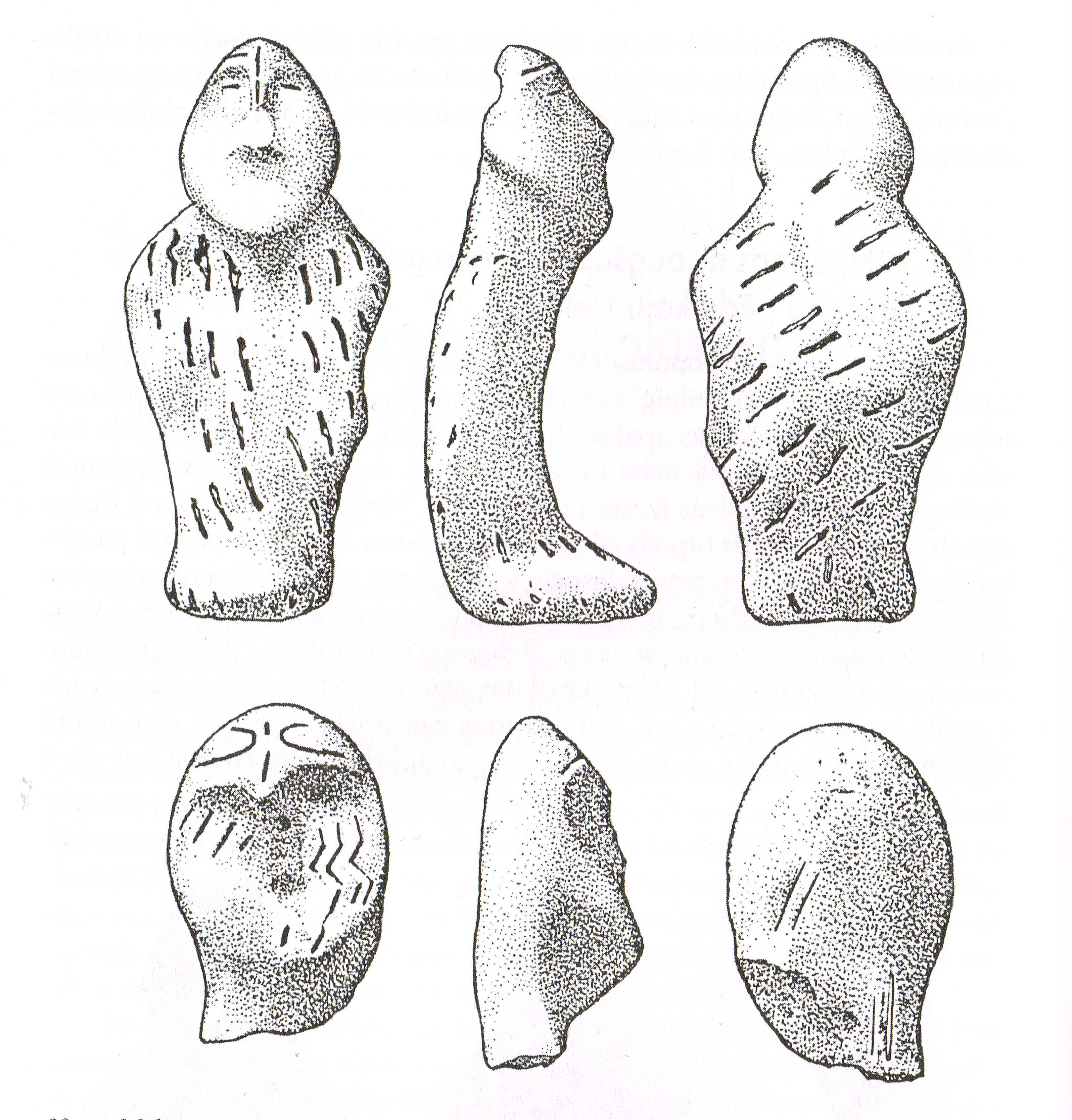
The most important discoveries came from Purciems Dwelling C, where Šturms observed two separate culture layers, preserved under the thickness of 1.60m of dune sand. The pottery fragments and artefacts (flint and stone artefacts, amber ornaments) from this dwelling indicate that it belongs to the local Middle Neolithic culture. In the lower level of Purciems C, three anthropomorphic clay figurines were found (one almost intact figurine and two broken heads from figurines), which were the first finds of this kind (Figure 8). Šturms published a paper on the results of the excavations and one paper devoted to the clay figurines in particular (Šturms 1937a 46–54; 1937b 83–91). According to Šturms, the dwellings unearthed at Purciems settlement belonged to three different Middle Neolithic culture groups.
World War II and Soviet occupation stopped any further research in the territory near the Baltic Sea. For 50 years, this part of western Latvia, the shoreline of the Baltic Sea, a western border of the Soviet Union, was under strong restrictions. In a way, the closed area ensured the preservation of both the archaeological heritage and the natural values.
Archaeological excavations in the North Kurzeme resumed in the 1990s, when archaeologist Ilze Loze started to work there. She observed the situation of the Purciems settlement and started the rescue excavations at Purciems Dwelling F, in connection with the erosion of the right bank of the Pilsupe Channel. There she discovered three culture layer levels were found. In the 1990s, Loze discovered the Ģipka A and Ģipka B Neolithic settlements.
Nowadays, along the slopes of the lower reaches of the Pilsupe, near the Purciems settlement, a wooden trail has been built for visitors, which reveals the sight of three white dune exposures (the largest is called the White Dune). This protects both the dunes and the Neolithic settlement from erosion caused by Pilsupe Channel floodwaters.
The settlement Ģipka B is located by the shore of the palaeolake, in the lee of the reworked dunes, protected from the sea winds. It is only 300m south of the Purciems settlement. During the archaeological excavations, the remains of two dwelling sites were discovered in the settlement. Marked by an area of dark earth with burnt stones, the remains of four hearths piled with stones and pits were found. There were flint artefacts (arrowheads, scrapers, knives, etc.), amber ornaments (pendants, beads, partly made pendants and beads), pottery (Comb Ware ceramics, organic-tempered pottery and Pitted Ware ceramics), and fragments of anthropomorphic figurines. Ģipka B was intensively inhabited during the time of the Comb Ware Culture in the Middle Neolithic. According to Loze, the remains belonged to a former permanent base camp inhabited all year around. The few pottery fragments found in the settlement may be assigned to the Pitted Ware Culture which shows developing contacts with Scandinavia at this time.
The settlement of Ģipka A, situated around 150m to the south-east of the Purciems settlement, located on a narrow belt of reworked dunes between the shore of the Litorina Sea and the Ģipka Lagoon (a later palaeolake). A culture layer gave evidence of three separate cycles of habitation. Four fences, i.e. low palisades delimiting the site from the east, were discovered there. These appeared as four ditches, with fills of dark brown sand. A large fireplace was found inside the enclosed area, while near the fireplace and the inner palisade wall fragments of a pottery vessel, powdered with red ochre, were scattered. Ochre had been used to colour the anthropomorphic clay figurines, or at least their faces. In this part of the site, two pieces of an anthropomorphic figurine were also found in a pit filled with grey sand, right next to the inner enclosure. The head of another anthropomorphic figurine, with a chin painted with ochre, was discovered next to a small hearth sunken into the white dune sand.
Other finds include flint implements (arrowheads, scrapers, knives, blades, etc.), amber ornaments (pendants, beads, and unworked and split pieces of amber) and polished stone tools (including fragments of a shaft-hole axe, and a fragment of a miniature slate chisel). The pottery from Ģipka A mainly consists of sherds from large vessels, tempered with crushed shell or some organic material, and belongs to the late phase of the Middle Neolithic. A small number of fragments of Pitted Ware, which could come from the Estonian islands or from Gotland, were found. It indicates the existence of contact between groups of people in the final part of the Middle Neolithic. Considering the archaeological excavations did not yield many artefacts and the find material only comprised everyday tools and pots, Loze concluded that the Ģipka A settlement was a seasonal site for rituals.
Between 2000 and 2003, an archaeological survey was carried out north of the settlements of Purciems and Ģipka. Four Middle Neolithic settlements with dwellings have been discovered here (Loze 2006 145–49). The newly discovered settlements show that the reworked dune area between the coast of the Ģipka lagoon, the later palaeolake, and the coast of the Litorina Sea were frequently visited in certain seasons. It seems clear that these dunes still conceal more archaeological evidence.
Protection and preservation of natural and cultural heritage is one of the topical issues of today. The economic development of land, which increases the use of natural resources, and the growing public interest in natural values and cultural history, resulting in the development of tourism, require a state-level environmental protection policy. In Latvia, the protection of natural and cultural values is under the responsibility of different ministries and their subordinate institutions. This gives an opportunity to develop a special regulation for their protection, but often when one of the interests prevails, the regulation does not give a balanced result. The location of archaeological monuments in protected nature territories forms multifunctional protected environments, the preservation of which requires a special approach, respecting all its qualities and values. The north-western part of Latvia is a culturally and historically important coastal region with an outstanding set of historical, cultural, and natural values. This territory has a high scientific potential, therefore a unified policy of preservation of natural and archaeological monuments is necessary at all stages and levels of management. Nature reserves, parks, and individual natural monuments have been established in it, the protection of which is ensured by the regulatory framework at a national level. Even though important archaeological monuments are located here, the area has not yet been extensively investigated. Preservation of natural and cultural values are not in conflict until the interests of management and use of certain territories conflict. In recent years, intensive territory development has been taking place in the coastal regions, which relates to the construction of private houses and the involvement of the territories in tourism. This requires the creation of new infrastructure, which can negatively affect the landscape, the traditional building structure of villages, as well as potential archaeological sites.
In the territories with outstanding landscape, and cultural-historically and archaeologically important sites, unified strict regulation would be necessary for balanced preservation of natural and archaeological values in the face of increasing anthropogenic impact. In most of the protected natural areas, the archaeological sites are well protected – however, the primary aim is the preservation of natural values. To ensure equal protection, the cooperation of society, municipalities and state institutions at all levels is necessary.
Internet Archaeology is an open access journal based in the Department of Archaeology, University of York. Except where otherwise noted, content from this work may be used under the terms of the Creative Commons Attribution 3.0 (CC BY) Unported licence, which permits unrestricted use, distribution, and reproduction in any medium, provided that attribution to the author(s), the title of the work, the Internet Archaeology journal and the relevant URL/DOI are given.
Terms and Conditions | Legal Statements | Privacy Policy | Cookies Policy | Citing Internet Archaeology
Internet Archaeology content is preserved for the long term with the Archaeology Data Service (ROR). Help sustain and support open access publication by donating to our Open Access Archaeology Fund.
 Home
Home