Cite this as: Miziri, E., Meshini, M. and Zoto, R. 2023 Butrint National Park 'Integrated Management Plan' - Combining Natural Park with Cultural Heritage, Internet Archaeology 62. https://doi.org/10.11141/ia.62.2
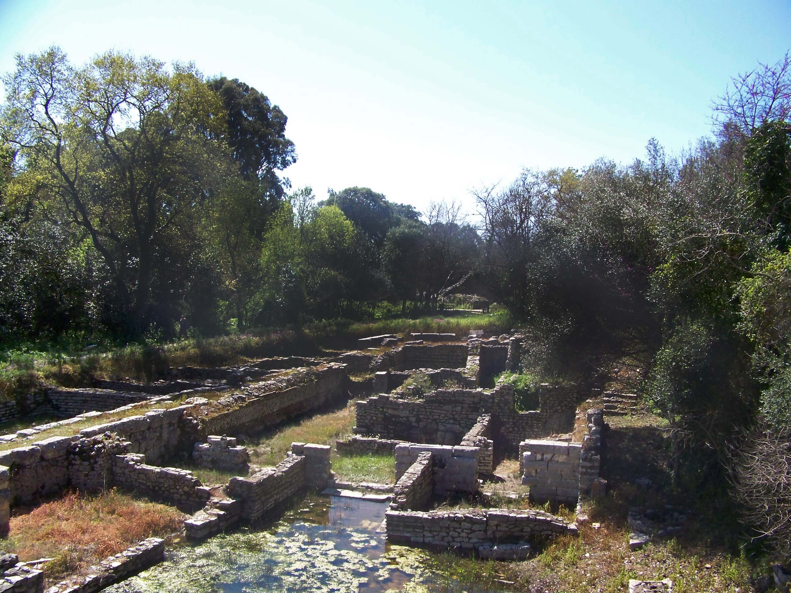
Butrint is the most important National Park in Albania, with its wonderful and particular duality as a natural and archaeological park. Besides its magnificent and monumental appearance, it is also a most attractive site, surrounded by many other natural and cultural resources. As such, the ancient city of Butrint requires a complex approach to enable the coexistence of both natural and cultural values (Figure 1).
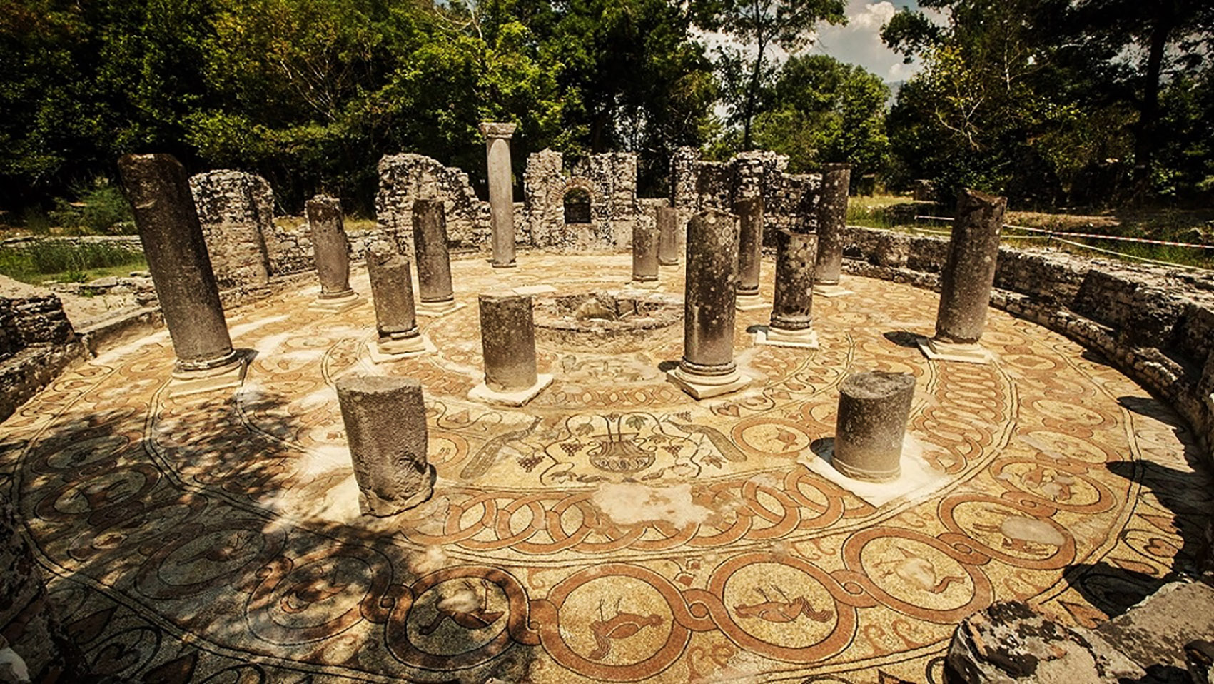
Butrint is located in the very south of Albania, and now occupies a total area of 16 hectares (protected by UNESCO), encompassing the area of the ancient city of Butrint as it now stands. It has a rich combination of hills, lakes, wetlands, open plains, reed beds and coastal islands. The remains of Butrint date from the Bronze Age through to the Ottoman era. It has particularly well-preserved features from the Roman and Byzantine periods, including beautiful mosaic floors (Figure 2). The present archaeological site represents each period in the city's development.
The Park combines archaeology and nature on Albania's Ionian coastline, and is an exceptional cultural landscape, which has developed organically over many centuries. The archaeological resources, including the historic landscape, unexplored archaeological sites, its strategic location etc. on one hand and the natural assets on the other coexist.
The Park of Butrint is listed in the Ramsar Convention (Ramsar 2003) due to its well-known and important plant and animal species - in total more than 1200 of them. Its combination of archaeology and nature, still with no modern development, gives Butrint a special spirit of place and authenticity.
In an administrative scheme covering almost two decades, the Albanian government followed a clear vision of protecting the park of Butrint by undertaking the following actions. In 1989, Albania ratified the World Heritage Convention concerning the protection of the world cultural and natural heritage (UNESCO 1972). In 1992, the site of 16 hectares was inscribed in UNESCO World Heritage Sites. In 1997-1998, Albania went through political instability during which time cultural heritage was not a priority, so the site did not receive the proper protection. In 2000, the boundary of the world heritage site of Butrint was extended to a total area of 2500 hectares, followed by another extension in 2013 of up to 9000 hectares. Three years later, in 2003, it was declared a National Park by the government.
In 2012, the National Park of Butrint implemented an Integrated Management Plan (IMP). Work on an update was started in 2019 and now, after more than two years, the updated IMP is ready to be implemented.
Nowadays, we are more aware of both cultural and natural values when updating and prescribing management routes (Figure 3). Before the introduction of the IMP, the Ministry of Culture or indeed other archaeologists found it difficult to undertake any archaeological intervention or research because of the complex permissions required by the Ministry of Environment and Tourism. Before the introduction of the IMP, therefore, the situation in Butrint Park was a bit chaotic and it became very difficult for the staff of the archaeological park to undertake any restoration and protective measures on the ruins and monuments. For example, in order to fell a tree where its roots were damaging entire walls, a long and difficult bureaucratic process had to be navigated. The problem was not only that the area was controlled by two authorities, the Ministry of Culture and the Ministry of Environment and Tourism, but also that these two authorities had opposing criteria and points of view about safeguarding the assets.
Butrint's main problem is water levels. We are facing this challenge today as a consequence of different atmospheric agents, global warming, and destruction of woods and vegetation in the surrounding areas. Being close to the sea level, the site is under constant threat, not from rain water but from the salt water that is penetrating from underground. A very difficult and complicated operation comes from the Vivari Channel, the only natural connection with the open sea. The Vivari Channel (a Hydro monument), enables the connection of the lagoon of Butrint with the Ionian Sea. The length of the channel is 2.5km, the width up to 80m, and the depth about 6-7m. Because of the tides, the channel water changes its flow direction every six hours. The channel also makes it possible to supply Lake Butrint with salt water, as well as fresh water, thus creating a unique situation with favourable conditions for the development of molluscs in this lake. Any intervention here is very hard to undertake, because of strict rules applied by the Ministry of Environment, protecting the assets of the Natural Park.
Butrint for many years has been the number one destination for both foreign and local tourists. It is known and described by the historians and archaeologists all over the world as a microcosm of the Mediterranean world, thanks to over three millennia of continuous history. It also gives visitors an unforgettable experience, being in the middle of nature, surrounded by dense vegetation and very rich flora and fauna. Visitors feel the calm and the peaceful atmosphere created by the combination of ruins, history, nature, water, landscape, all of which makes Butrint unique.
The extended protected area of the park also has other components to consider, such as the local community, management of property, economic development, and tourism which was also drafted into the management plan approved in 2021 (IMP 2021). The plan was prepared for the Albanian-American Development Foundation by 'Prince+Pearce Limited' (UK) in 2019, in association with the Centre for Applied Archaeology, Institute of Archaeology, University College London, and Cultural Heritage without Borders, Albania, with the contribution of the staff of Butrint Park. The role of the Ministry of Culture as initiator and beneficiary was also most important.

The Albanian government owns the property and has the responsibility for all its natural and cultural assets. The IMP has foreseen that the park is going to be a foundation that generates income, has its own financing and is responsible for investments with actions evaluated and decided by the board which is responsible for activities in the park. The commissioners are appointed by the Ministry of Culture, Ministry of Environment and Tourism and other specialists (in a balanced way). The board undertakes any decision concerning the park, such as interventions in cultural heritage, environment assets, tourism, and financial management. It has a site management team who organise all the activities and implement the action plan. The aim of IMP is to offer a safe and wonderful experience to visitors with no damage to the site and to make the public more aware of Butrint National Park's values.
The Ministry of Culture administers and is responsible for related assets of cultural heritage, which are specifically divided into sub-areas e.g. 'A3 zones'. Specifically, these consist of the peninsula where the ancient city of Butrint is located, the Roman quarter outside the city in the Vrinva area and in Malathrea. This area, with its natural assetsand archaeolog is co-administered by the Ministry of Tourism and Environment. The A3 zone measures 615 hectares and the foundation extends its activity to within this area.
The IMP board is in charge of evaluating all the complexities of any situation, and must make very quick decisions. Now the coexistence of assets in one park is regulated by law. Each asset is evaluated and activities carried out in a harmonised way. The evaluation of the coexistence of assets in IMP is key to managing the activities in the park.
In ten years, hopefully, the community will be involved more, and aware of their key role for a sustainable economy and tourism. Investment opportunities are now open for the local communities and where their tourism activities can be promoted and integrated. Stakeholders can now all associate around a unified, sustainable development strategy.
There is now an easier way to undertake any archaeological intervention or research on the cultural heritage itself. The generated income will be distributed to enable interventions in restoration and the maintenance of cultural assets. Natural resources will now be easier to develop because of ecological monitoring and ongoing restoration programs finding sustainable practices, i.e.:
All these components come together in harmony and balance. The IMP has assessed all the required research and put in focus the real values of the site. As a positive and sustainable solution in the framework of cultural management, the Butrint National Park Integrated Management Plan can be an example to be followed by other archaeological parks with similar features.
Internet Archaeology is an open access journal based in the Department of Archaeology, University of York. Except where otherwise noted, content from this work may be used under the terms of the Creative Commons Attribution 3.0 (CC BY) Unported licence, which permits unrestricted use, distribution, and reproduction in any medium, provided that attribution to the author(s), the title of the work, the Internet Archaeology journal and the relevant URL/DOI are given.
Terms and Conditions | Legal Statements | Privacy Policy | Cookies Policy | Citing Internet Archaeology
Internet Archaeology content is preserved for the long term with the Archaeology Data Service (ROR). Help sustain and support open access publication by donating to our Open Access Archaeology Fund.
 Home
Home