Cite this as: Izeta, A.D. and Cattáneo, R. 2023 Towards an Open Digital Ecosystem for Archaeology in South America: The BADACor (Córdoba Archaeological Sites Database) as a case of an open digital archaeological source for heritage management in central Argentina, Internet Archaeology 64. https://doi.org/10.11141/ia.64.16
It is widely acknowledged that open science and open archaeology have been steadily developing worldwide in recent years (Kansa and Kansa 2013; Lake 2012; Marwick et al. 2017). Digital archaeology has undoubtedly facilitated progress in discussions about sharing the knowledge generated, not only through publications but also through databases and methodologies that enable better reproducibility of results (Marwick 2017; Marwick and Birch 2018; Marwick and Schmidt 2020). This has allowed more and more professionals and those interested in the discipline to start sharing data that contribute to a better understanding of our past and present. In fact, much of the literature generated in the last ten years reflects the concerns of professional archaeologists about how to make archaeology more open to colleagues and the public. However, there are still regions where the development of this practice is still developing, particularly in what is now geopolitically recognised as the 'global south' (Izeta and Cattáneo 2019, Salerno 2013), a place that encompasses a large part of the world and an important percentage of the world's population. Nevertheless, Latin America is positioned as a territory in which the development of open science ecosystems is in full growth. In many of the countries that constitute this territory, including Argentina, higher education and scientific research are mainly financed with public funds. Therefore, research financed by the public must return as knowledge to the citizens of each country. This has allowed the growth of a regional movement towards making open access mandatory for research and education funded in this way.
However, open science is more than just open access. UNESCO has approved a definition agreed upon by member countries on Open Science, defining it as:
'an inclusive construct that combines various movements and practices aiming to make multilingual scientific knowledge openly available, accessible and reusable for everyone, to increase scientific collaborations and sharing of information for the benefits of science and society, and to open the processes of scientific knowledge creation, evaluation, and communication to societal actors beyond the traditional scientific community. It comprises all scientific disciplines and aspects of scholarly practices, including basic and applied sciences, natural and social sciences and the humanities, and it builds on the following key pillars: open scientific knowledge, open science infrastructures, science communication, open engagement of societal actors and open dialogue with other knowledge systems' (UNESCO 2021)
Complying with all these standards is the most desirable way to undertake open science, as we understand that this method implies more than public access to scientific information. It represents a movement that involves not only making information available, but also using it to question and critique the process and results of science and to identify best practices. However, it requires researchers to address issues of scientific reproducibility, data quality standards and standardisation, and processes for sharing resources (Gupta et al. 2020; Izeta et al. 2021, Marwick et al. 2017; Nicholson et al. 2023; Richards 2009). The benefits of open science extend beyond science, to users of research, including policymakers, heritage managers, companies, and the public, contributing to the construction of rights.
This work focuses on presenting and discussing three aspects: open scientific knowledge, open science infrastructures, and their relationship with citizenship, other systems of understanding the world, and the acquisition of rights. In the first aspect, open scientific knowledge, we include open access, open data, and open methods, as suggested by Marwick and colleagues in their article in the SAA Archaeological Record (Marwick et al. 2017). Likewise, we understand open archaeology as the disciplinary expression of the recommendations of open science applied to archaeological practice. To discuss an advance on this form of conceptualisation and work, we will take a case study: the Database of Archaeological Sites of the Province of Córdoba (BaDACor). This instrument was co-constructed between professional archaeologists (academics from both public and private organisations), local government agents, heritage managers, indigenous populations, stakeholders, and the public interested in the preservation and management of archaeological heritage. Finally, we will reflect on its current use and future prospects in the region.
What do we understand by a database system in archaeology? Following Date and Faudón (2001), we understand a database system as a computerised record-keeping system whose general purpose is to store information and allow users to retrieve and update that information based on requests. Therefore, digital databases designed to store, manage, and disseminate archaeological data are what we recognise as an archaeological database system. These may include information on artefacts, ecofacts, site and landscape features, among other attributes of interest for archaeological interpretation. These databases are of great importance as they facilitate the exchange, preservation, and analysis of archaeological research data in a systematic and organised manner. In addition, their use allows the integration of various sources of information from disparate archaeological projects. By providing a centralised repository of archaeological data, these systems allow researchers to conduct more extensive comparative analyses and investigate broader research questions that go beyond individual projects, or purely descriptive interests, contributing significantly to the advancement of archaeological knowledge and understanding.
However, in practice, the vast majority of database systems are found in closed systems that do not allow open access to information, much less integrate new data or its re-elaboration. This happens because the databases are stored on personal computers that act as repositories of this information. Later in the life-cycle of the data, once they have been used, they are discarded, or simply lost as a result of hardware failures or outdated software that does not allow them to be retrieved.
In Argentina, open and collaborative databases, with a few rare exceptions, are not common. Although it is worth saying that since 2017, with the creation of the Argentine Digital Archaeology Network (Izeta and Cattáneo 2019), the availability of databases with free access is increasing. This is particularly the case with catalogues or nomenclatures that describe collections of objects or, as in the case study that we present here, of archaeological sites and which we describe with the acronym BaDACor.
The Database of Archaeological Sites of the Province of Córdoba is a digital, open, and collaborative access product that has been developed and updated since 2009. In recent years, along with the development of digital archaeology in Argentina, we have been building this database of archaeological sites in the central region of Argentina, which has allowed us to compile a catalogue of more than 2300 archaeological sites for this territory. One of its main achievements is that it constitutes the founding database of the official index of archaeological sites of the government of the Province of Córdoba, an entity that currently uses it and has made it grow. With this, it has allowed knowledge to be ordered relating to the distribution of inhabited spaces throughout the history of human occupation of the current provincial territory. On the other hand, it offers information and serves as a tool for those who want to know the provincial archaeological potential. This, and what we will see later, has been decisive for groups interested in the preservation of cultural heritage in the face of possible cases of heritage destruction (such as the construction of large infrastructure works). It has also been valuable in cases of a positive nature, such as when protected territories are created, for instance reserve areas or provincial or national parks.
BaDACor emerged as a result of the project 'Territorial Planning of Rural Spaces in the Province of Córdoba' IDB PID 013/2009 (Foncyt-Mincyt/Córdoba) directed by Mgter. O. Giayetto (UNRC) and coordinated by Dr M. Zak (UNC). This project originated in 2009 through the initiative of the Secretariat for Scientific Promotion of the Ministry of Science and Technology of the Province of Córdoba, Argentine Republic. The main goal was to generate basic information to enable forecasting and resolution of conflicts in the use of rural areas in Córdoba. From its conception it was understood that, in order to carry it out adequately and achieve its objectives, it was necessary to set up an interdisciplinary research team. Thus, the project was made up of 97 researchers, scientists from different disciplines, and recognised trajectories (Giayetto and Zak 2019). Its development was made possible by the financial support of the Ministry of Science and Technology (MinCyT) of the Government of the province of Córdoba and the Fund for Scientific and Technological Research (FONCyT) of the National Agency for Scientific and Technological Promotion of the Government of the Republic of Argentina. (For more information, see http://www.ordenamientoterritorialcba.com/)
Within this framework, one of us (RC) was responsible for carrying out the subproject or thematic layer linked to archaeological information, thereby leading to the construction of a Geographic Information System (GIS) to promote heritage management. Various researchers took on the commitment to collaborate by providing information produced during their projects from many national and provincial institutions (Cattáneo et al. 2015).
The final product of the project was a GIS whose general objective was to create multiple layers of environmental and cultural information to respond to the three spheres on which human development depends (biophysical, socio-economic, and infrastructural). Integrating multidisciplinary information allowed the identification of conflicting spaces and activities. Moreover, we were able to model risk areas for heritage, the planning of its management and/or use, and ultimately, the provincial land use planning.
This work covered, at that time, the urgent need for an updated registry of archaeological sites that would provide information related to site condition, allowing the improvement of management protocols. Also, an updated database allowed the province to comply with recommendations of international bodies such as the Organization of American States, UNESCO, ICOMOS, among others. It also allowed us to fulfil the requirements of National laws (Act 25743/03 and 26160/13) considering heritage management (Cattáneo et al. 2015; Izeta and Cattáneo 2021). It should be noted that at that time, there was no official geo-positioned registry or digital database for the province of Córdoba, just as it does not even exist for many of the provinces of the Argentine Republic.
On the other hand, in a social framework of archaeological practice, the need for a multivocal approach that includes the various communities in the construction of and discussion about their heritage is also recognised. Since archaeological practice inevitably has social and political consequences, it was proposed to work from a social perspective (Endere and Curtoni 2006; Endere and Prado 2009), that is, including the voices of the communities in the construction of their cultural heritage (Atalay 2008; Endere 2007; Haber 1999; Hernando Gonzalo 2006; Wharton 2005). Accordingly, we worked together with local informants, members of native communities, citizens interested in heritage, memory, and local identities.
Between 2009 and 2015, spatial data (published and/or public data), data origin (bibliography), chronologies, and associated material culture were integrated into the database. To do this, we adopted criteria established for the Database of Archaeological Sites of the Argentine Republic proposed by the INAPL (Rolandi 1998). In a second stage, which began in 2020, progress was made in the assignment of standardised descriptive metadata, which implied the adoption of standards such as the Dublin Core metadata scheme, the CIDOC-CRM conceptual reference model; the SNRD (National Digital Repositories System) Guidelines; the WGS84 geodetic coordinate system, lists of standardised terms (Getty ATT, TGN, etc.), of Argentine localities (datos.gob.ar), IDECOR's GIS layers, and the INAPL's RENYCOA Unique Record Sheets.
In the last fourteen years, BaDACor has had two major updates: one in 2015 and another in 2020, which is still ongoing. Different versions of the database are found in csv (comma-separated value) format on workstations of the Institute of Anthropology of Córdoba, although its public interface can be found in four electronic research infrastructures: the Suquia Institutional Repository (Dspace), IDACORDig (Arches Project), ARIADNEplus, and in Wikidata.
The database is structured into ninety-eight fields that are grouped into six categories, which correspond to the following:
In all cases, some fields are publicly accessible, while others are reserved for use by authorities (heritage managers, heads of local governments, etc.), for data preservation and sensitivity reasons. Each group contains a series of native terms and definitions (not standardised) and others as controlled vocabularies that follow the standardisation proposed by the ARIADNEplus project (Meghini et al. 2017; Niccolucci and Richards 2013; 2019).
This group contains fields that assign unique identification numbers to each record. As the database is spread across various platforms and has developed over time, ten fields can be found here. These fields contain the order number in which the record was entered, the unique numerical identification of the site, and the original identification. Additionally, the Wikidata QID, the Suquía ID, the URI assigned by Suquía, the title (name of the site), and the codes or alternative names are included. The general description of each individual record and the normalised description of the topic can also be found here.
This group contains two types of fields: those associated with geospatial location data and those of temporal association. In the first instance, the administrative division structures of the Argentine Republic and, in particular, of the Province of Córdoba are used, such as province, department (with its numerical coding), district, locality, place, or neighbourhood. Several fields detailing the spatial coverage (latitude and longitude), coordinate system, height above sea level, and extension of the site are also included. When no exact position of the site is available, a non-exact description of the location of the site (narrative description of the location) is offered. The quality of the data, defined by the method by which it was acquired and its precision (taking it in the field with GPS, by interpolation in geographical charts, or using geomatic analysis), is also supplied. Owing to the need to mask some exact location data, a series of fields have been added that provide information on the equivalence between the original locations and the random locations generated during the geomasking process (Smith 2020). Finally, the general location is described in terms of the geoforms that contain it and the associated hydrographic basins.
Regarding chronology, the determined fields correspond to the local definitions of culture, cultural period, geological period, century (in ISO 8601 format), radiocarbon dating, and interval 'from-to'. If a period has been defined within the PeriodO gazetteer, the name of the period and a hyperlink to its persistent marker are added. The methodological decisions for each field follow, in general terms, what Binding and Tudhope proposed for the ARIADNEplus database (Binding and Tudhope 2023).
These fields describe both the site and the material culture associated with it. This grouping combines native and other standardised definitions. In the latter case, the proposal of the structured vocabulary the Art & Architecture Thesaurus (AAT) (Getty Research Institute) was followed. This has been used to define the classification of sites and associated objects.
This group offers data on issues related to the level of intervention at the sites, the risk of damage from cultural or environmental actions, and the current visibility of the spaces in which the sites are located. They are particularly orientated towards generating a field for the construction of risk maps.
This group of fields provides information regarding the origin of the data - for instance if it is part of a museum collection or retrieved from published or unpublished sources. In the case of the latter, the citation, page number, authors, copyright of the publication, external URL, and URL in the Suquia repository are included. To complete these fields, a parallel work was carried out to compile academic works from 1872 to the present, and a collection was built in the Suquía Repository (Izeta et al. 2021).
Finally, there are fields used to register the management of the records and their updating. Here, we can find data such as who was responsible for entering the record, the date of creation and modification, whether the data was transformed into the RENYCOA files, and the version of this file. Additionally, the language in which the record is found, the access rights to the registry information, who published it, and the person in charge of the registry are recorded.
To carry out the project, the following activities were undertaken:
It was important to differentiate and make explicit the origin of the data with respect to the spatial location of the locality, site, or collection inventoried. Specifically, how the location data was generated, and therefore with what degree of accuracy/validity or error it was conveyed, is crucial. In many cases, this criterion, associated with bibliographical references, allows us to infer, for example, the level or grade of intervention of a site. This also helps in planning surveys in areas that have not yet been worked on, or where the risk of altering a site is very high.
Thus, we used three types of data origin:
Regarding georeferencing, point location systems in space have a long history that can be traced back to the remote past of human societies. However, modern systems developed alongside the advances by Asian and European societies in the art of navigation. This produced the first maps that allowed locating a certain body in the space of the terrestrial surface through different natural phenomena. This location can be based on exact (quantitative) and non-exact (qualitative) methods. In general, the first descriptions of the territories have always been qualitative in the absence of an exact spatial representation. This can be observed through manifestations such as rock art, which is often interpreted as a representation of the territories occupied by ancient societies in the past. Travellers' and naturalists' journals have also provided, in many circumstances, positioning data that allow the approximate location of ancient settlements, routes, or particular geoforms in various landscapes of the planet.
On the other hand, exact georeferencing can be done using different methodologies (Conolly and Lake 2006; Wieczorek et al. 2004). The most common approach between the 15th and 20th centuries was based on the use of maps or charts that are two-dimensional representations of territory. These charts are constructed, depending on the use for which they are intended, following different projection systems that favour the reliable representation of angles or distances. For this reason, it is of great importance to know the type of projection used in the charts when georeferencing a point using the interpolation technique. Likewise, interpolation from field data may introduce location errors dependent on the scale of the base chart used.
In view of this, the data that we sometimes obtain about the location of archaeological sites tend to vary in accuracy. For this reason, during the data entry process to the Córdoba archaeological sites database, it was necessary to assess the information quality in each case.
According to Wieczorek et al. (2004), there are four types of georeferencing: the point method, the polygon method, the bounding box method, and the point-radius method. Each has its disadvantages, which in general are summarised in the capacity of each one of them to best determine the location of an observation within a locality.
Owing to the scale used in the original project (1:250000), we decided to use the first methodology, which involves assigning a pair of coordinates to each location. According to Wieczorek et al. (2004), one of the biggest disadvantages of this method is that, generally, a qualitative description describes an area and not a point on the ground. So if a point is provided for a georeferenced record, the distinction between specific and non-specific localities is lost. However, this methodology is used repeatedly by various databases and site nomenclatures at an international level such as ARIADNEPlus, Zbiva, DINAA, ArchSite Online Geodatabase, and EAMENA (McCoy 2020; Niccolucci and Richards 2013; Pleterski 2016; Štular 2019; Wells et al. 2014; Zerbini 2018). Using points for describing site locations allows interoperability between the various software program implementations.
In BaDACor, the information on the spatial location of each archaeological site was differentiated according to the type of data into exact and non-exact. The non-exact data always has an element of uncertainty and must be taken to refer to the possible location of a site. On the other hand, the exact location data has no uncertainties, but in many cases, we needed to conceal the real location to preserve these spaces because they are significant for native communities (Gupta et al. 2020).
The georeferencing of non-exact data was carried out through the implementation of the MaNIS/HerpNET/OrnIS protocol (Mammal Networking Information System/Herpetology Network/Ornithology Information System). This protocol takes into account that the descriptions of qualitative type locations can be plotted in a geographic coordinate system with a variable level of uncertainty, but that allows a relatively adequate location at small or medium scales. The data associated with the archaeological sites that determined the place of origin were considered and could be assimilated to one of the nine types defined by Wieczorek et al. (2004). In particular, it was defined as 'place name', which can be associated with a town, cave, lagoon, or other geographical feature that has a spatial extension.
It is important to highlight how BaDACor relates to the digital universe, both locally and globally, and how it maintains its validity and interoperability. The most significant features were considered when creating its structure. It is embedded in four instances (platforms and repositories) that show various characteristics of the database, constituting a digital ecosystem that allows for its permanent updating (Figure 1). These instances are:
Each instance emphasises aspects such as conservation, geolocation, integration with other databases (Cattáneo et al. 2015; Izeta et al. 2021; Izeta and Cattáneo 2019), and the ability to add data by the community following a bottom-up model (Belford 2011).
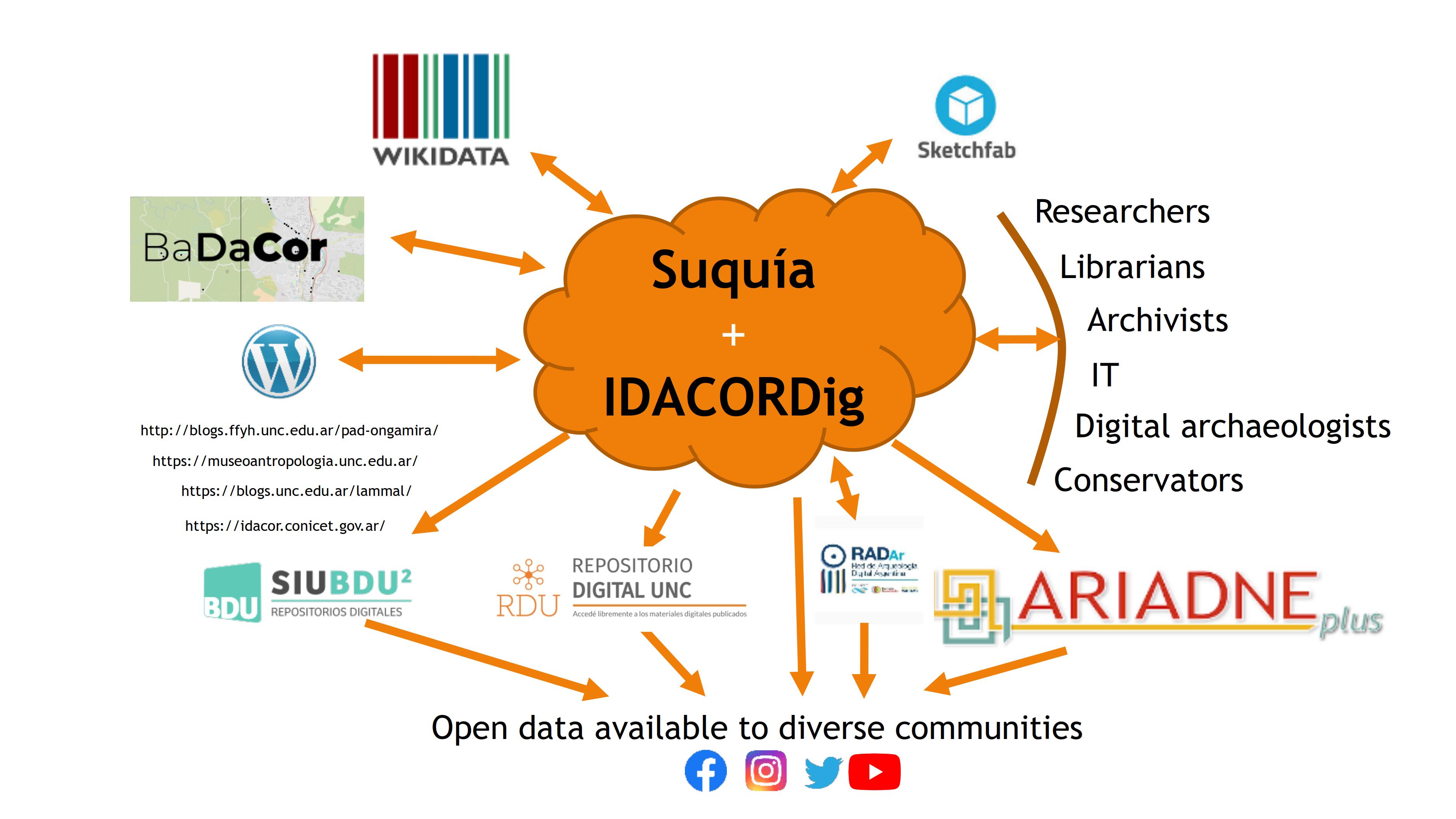
Figure 1 shows the digital ecosystem where BaDACor is developed. These four instances run on various software that allow data interoperability under the LOD (Linked Open Data) model, thereby complying with the third FAIR principle (Wilkinson et al. 2016). Two of the instances are local facilities located within the framework of the electronic infrastructure provided by the Pro-secretariat of Informatics of the National University of Córdoba. These are the Suquía Repository, which runs under a DSpace instance (Izeta et al. 2021), and IDACORDig, an implementation of Arches software. The other two spaces in which BaDACor develops correspond to international spaces such as ARIADNEPlus (Štular 2019) and Wikidata (Vrandečić and Krötzsch 2014) .
The Suquía Institutional Repository was developed as a digital platform for the preservation and dissemination of cultural heritage in Argentina (Izeta et al. 2021). It serves as a repository for the digitisation of cultural material and aims to provide public and free access to it. The Suquía Repository includes a diverse range of cultural material, such as documents, photographs, maps, newspapers, video, and audio recordings. This digitisation of cultural heritage is essential to guarantee the conservation and accessibility of documented material associated with archaeological investigations. In addition, the Suquia Repository serves as a valuable resource for researchers, scholars, and students seeking to research or learn about Argentina's cultural heritage. By making cultural heritage materials freely available to the public, the Suquia Repository seeks to promote a more informed and educated society by promoting access to knowledge (Izeta and Cattáneo 2019). The Repository is structured into communities, subcommunities, and collections. BaDACor is a collection that aggregates information from 2390 archaeological sites following the criteria described above. It can be located at https://suquia.ffyh.unc.edu.ar/handle/suquia/4733. Each site has its own page within this system, where a set of metadata can be found that describe the properties of the place and to which a PDF file is associated, containing the fields requested by RENYCOA in its single FUR registration form (https://inapl.cultura.gob.ar/noticia/nuevas-fichas-unicas-de-registro-fur-de-bienes-arqueologicos/). Some other data specific to BaDACor are also added to this data.
IDACORDig runs under an implementation of Arches, which is an open-source software platform that allows the creation and management of complete inventories of collections through a web interface. Arches was developed by the Getty Conservation Institute and Farallon Graphics in collaboration with various partners (Myers et al. 2016). The importance of this system is that it facilitates the management of spatial data, such as mapping and geospatial analysis, and allows the entry of data in several languages, which complements the data found in the Suquía Repository. Arches uses the CIDOC CRM and its extensions orientated to the description of objects, people, and events related to archaeology (Doerr et al. 2018; Ronzino et al. 2016).
The ARIADNEplus project is an extension of its predecessor, ARIADNE, which aimed to merge pre-existing data infrastructures for archaeological research (Aspöck 2019; Geser et al. 2022; Richards and Niccolucci 2019). BaDACor is also included in this specific international archaeology initiative. ARIADNEplus established a comprehensive and interconnected digital infrastructure that supports research, fosters collaboration between scholars and institutions, and enhances the dissemination of archaeological knowledge to diverse audiences (Niccolucci and Richards 2013; Štular 2019). ARIADNEplus promotes the sustainability of the infrastructure by instituting policies and procedures that ensure the long-term preservation and accessibility of archaeological data, as well as fostering the development of a community of practice focused on exchange, management, and administration of data. For this reason, the integration of BaDACor in this type of initiative has allowed international visibility within the academic field.
Lastly, BaDACor integrates with Wikidata, which is an open and free database that can be edited and used by anyone. It was launched by the Wikimedia Foundation in 2012 as a sister project of Wikipedia, and its goal is to provide a common repository of structured data that can be used by Wikimedia projects and other third-party applications (Vrandečić and Krötzsch 2014). Wikidata allows users to store and manage structured data in one central place, making it easy to reuse across multiple projects and platforms. The data stored in Wikidata can be linked to other data sources, such as Wikipedia articles, or in our case, BaDACor, to provide additional and contextual information. Wikidata uses a flexible data model based on entities, which can represent anything from a person or a book to a chemical compound or a geographic location. Each entity is assigned a unique identifier, known as a QID, which can be used to link the entity to other data sources. This platform is the only one that allows the entry of data by anyone in the community, which provides great potential for collaborative work with communities (Schmidt et al. 2022). However, we understand that this, which is a strength, can also be one of Wikidata's shortcomings owing to the possibility of data modification by anyone (Heindorf et al. 2016; Schmidt et al. 2022).
So far, we have seen the structure of BaDACor, how it was shaped over time, and the potential scope for accessing its data from its integration in different instances and at different levels. This integration allows BaDACor to be accessible not only to experts, but also to interested organisations and citizens who may not necessarily have technical knowledge about archaeological heritage. Additionally, since it is included and standardised according to international standards, it allows access through different languages, thus guaranteeing access to a wider audience.
Now, we will focus on the use of this database for heritage management, taking two models that we can define as Top-down and Bottom-up (Belford 2011). In our case, we understand the Top-down model as one developed by decision-makers for cultural heritage. It is a hierarchical way of establishing who influences, for example, the management of cultural heritage or, on the other hand, how legal corpora are developed that allows them to be given a general framework. The state is the one that activates the heritage and the subsequent management of it (Prats 2005). This is why in this model, offices related to heritage management, legislators, and professional archaeologists working in various levels of the state organisation are involved (e.g. Heritage Boards, research agencies such as CONICET or national universities). This model is developed in the areas of decision-makers or heritage managers, as well as in academic spaces, where the participation of local communities of non-experts is often not considered (Figure 2).
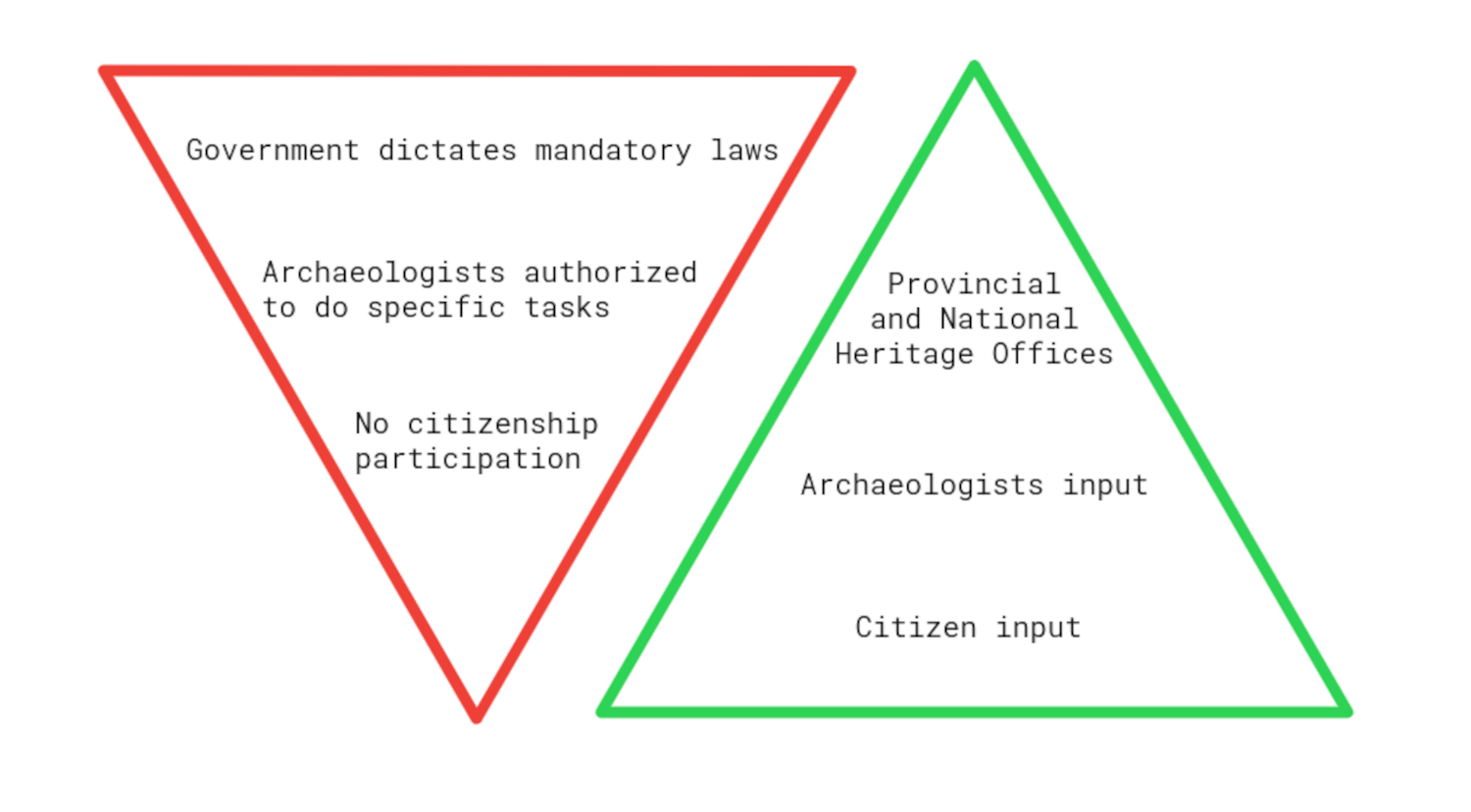
The bottom-up model is related, in contrast, to the impetus given by both individuals and interest groups to the development of policies for the recovery, visibility, and preservation of what we recognise as heritage (Figure 2). These activities are triggered by private interests (enthusiasts, advocates, etc.) and by community interests (defence of historic buildings, landscape, etc.). Nevertheless, it often requires the involvement of archaeologists at some point in the process of 'activating' (sensu Prats (20051) places to turn them into heritage/archaeological sites (Figure 2). In contrast to the first model, in this case the mobilising force comes from the citizens or communities, made up in general of non-experts in archaeology.
As noted earlier, BaDACor was built from a research project planned after identifying a need to carry out the territorial ordering of the rural areas of the province. The main actors who participated belong to the academic sector, represented by researchers and professors from the National Universities of Córdoba and Río Cuarto and from other scientific and technical organisations established in the province (e.g. CONICET, INTA, INA).
Throughout the process of creation, survey, and loading of data, the top-down approach was applied since the purpose of this database was to be used in the management of heritage by different Heritage Offices (provincial and municipal). For this reason, although various stakeholders interacted during the database construction, the perspective that prevailed was the institutional/academic/state-governmental one.
In August 2015, the base was handed over to the Córdoba Culture Agency, which through the Heritage Department is in charge of protecting the provincial archaeological heritage. For the first time, the province had access to a comprehensive list of archaeological sites that increased the number of registered sites by more than 900%. In other words, it went from an inventory of about two hundred sites to knowledge of more than 1900 places of archaeological interest (Figure 3c). This led to permanent employment positions to maintain and increase the data contained in the database held by the province, and that from 2015 became the official database of archaeological sites.
This also made it possible to generate three projects for the creation of 'Archaeological Reservations' that were added to the protected natural areas of the province. The first two correspond to the Quilpo Archaeological Reservation and the Guasapampa Archaeological Reservation (Álvarez Ávila and Palladino 2019; Boletín Oficial 2015). The third is the Cerro Colorado Archaeological Reservation (Boletín Oficial 2019). From these actions, we can see the importance of the official use of BaDACor for heritage management from the state point of view.
On the other hand, in recent years, BaDACor has become more accessible due to the demand for information from actors and citizens interested in protecting archaeological heritage. Since the publication of The Archaeological Heritage of the Rural Spaces of Córdoba (Cattáneo et al. 2015), which was available in both physical and electronic formats, various actors from communities interested in heritage preservation have contacted us for more precise information than that provided in the publication. This led us to work on opening up BaDACor data to the community, following the methodological precautions described above, to make it a tool for citizens interested in heritage preservation.
When we began participating in ARIADNEPlus in 2019, in the province of Córdoba there was a growing drive to implement highway constructions, which clashed with local populations who wanted to maintain their rural way of life. These groups mobilised owing to the threat that any major infrastructure project can pose to the environment (Campana and Dabas 2011). However, after our team's participation in the 2018 public hearings, they considered heritage issues in a more informed way and utilised information related to the archaeological heritage of the region.
Different social organisations, environmental groups, and citizens began using the platforms and repositories where BaDACor is located, mainly to obtain data for legal claims in cases of conflict with the state over the destruction of heritage or ancestral territories.
A specific case of extensive social conflict in the provincial territory is the expansion project of National Route 38 in the Department of Punilla. The project aims to create a four-lane mountain highway to link the capital of the province of Córdoba with the capital of the province of La Rioja, Argentina. It would cross a densely populated valley that has been effectively occupied for some 12,000 years. This valley is one that historically has presented a higher frequency of archaeological sites and remains compared to other areas of the province (Cattáneo et al. 2015) (Figure 3).
The Highway 38 project in Córdoba, Argentina, is a government initiative to build a high-speed highway connecting the city of Córdoba with the northern region of the province over a distance of about 190km. The project was the subject of debate and controversy owing to concerns about the environmental and social impact of the construction of the highway on local communities and natural ecosystems. Moreover, people realised that the project concealed a real-estate development proposed as gated communities, to the detriment of traditional ways of life, without evaluating the environmental risks of continuing to destroy the aquifers and native forest (Collo and Uanini 2022).
In 2018, the provincial State presented a project called 'Alternative to Route No. 38 Puente Costa Azul - La Cumbre'. Following the rules that regulate this type of work, an environmental impact study was carried out (Caminos de las Sierras 2018), which was almost unanimously disapproved of by the academic community and the general population. This was evident in the public hearing that allowed the presentation of information by the local community and experts from the National University of Córdoba and CONICET, among others. Regarding the survey of archaeological information, the use of BaDACor was noted regarding the estimation of the archaeological potential of the projected work area (Caminos de las Sierras 2018).
Figure 3 shows that the opposition of local communities, environmental organisations, and indigenous communities was based on the damage to natural habitats, particularly the native forest, and the destruction of the territories of communities with traditional ways of life, such as family-scale cattle raising. The highway also endangers the integrity of ancestral territories loaded with symbolism for the aboriginal communities, including recognised archaeological sites and territories that have never been studied or investigated.
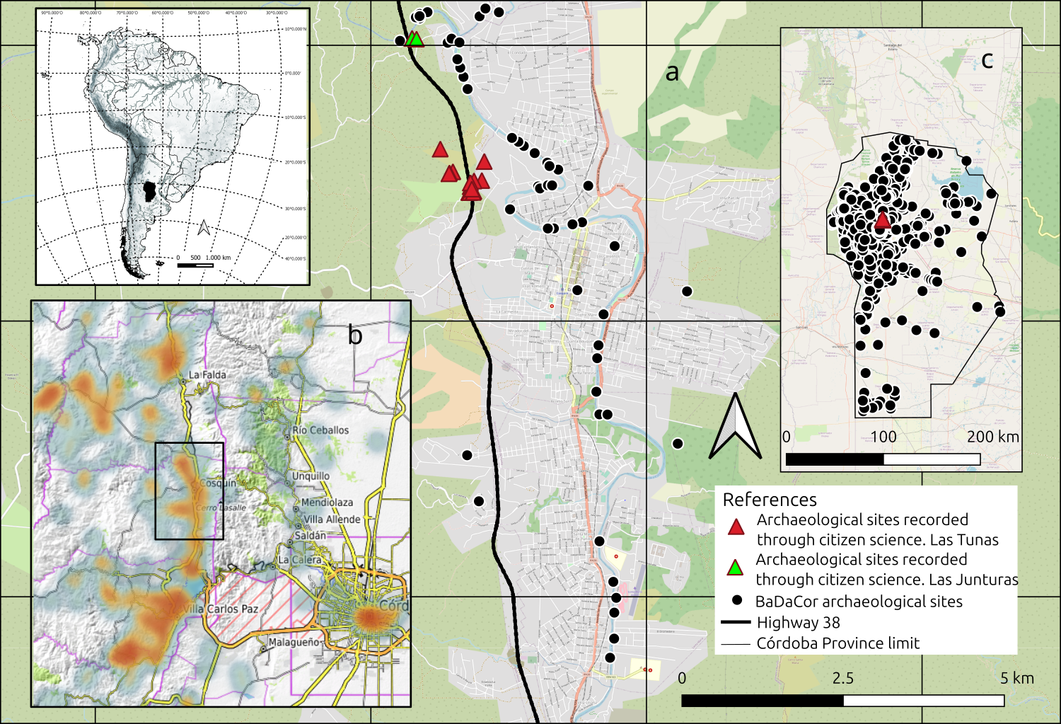
Highway 38 runs through several archaeological sites of cultural importance, some of which date back to pre-Columbian times and are significant for indigenous communities (Figure 3a). Their destruction not only causes the loss of cultural heritage, but also severs the connection of communities with their history. On the other hand, there is also concern about the irreparable damage it could cause to the cultural landscape, resulting in the loss of cultural and social values.
The protests against the project included a march held on 31 August 2018, in the centre of the city of Córdoba, where around 15,000 people participated under the slogan 'No to the mountain highway'. After these events, the project was postponed by the Governor in October of that year. In 2020, a new route was proposed, this time along the western slope of the Punilla Valley. This new Highway path also had an environmental impact study that carried the same errors and lack of information as the first (Caminos de las Sierras 2021; Collo and Uanini 2022). Therefore, in the public hearing, almost 90% of the exhibitors presented arguments to reject it, including the vast majority of the academic community and the general population. Despite these concerns, the construction of Highway 38 has continued, resulting in confrontations between protesters and the police, and generating social conflict as a result of opposition from groups concerned about its negative consequences. Moreover, despite the opposition of the communities, the construction of Highway 38 has resulted in the destruction of several archaeological sites.
This has caused anger and frustration among communities, as well as concerns about the lack of measures to protect these sites. However, at this stage, the greatest interaction took place between various interest groups representing local people, indigenous communities, politicians, heritage managers (at the local, provincial, and national levels), and academics. The actions of environmental and heritage activists, who are grouped in 'neighbourhood assemblies' formed in the early stages of the fight against the highway project, have been and continue to be key in protecting the archaeological heritage (Britos Castro et al. 2022; Collo and Uanini 2022).
In April 2021, when face-to-face activities resumed in Argentina after the COVID-19 pandemic, we were invited to give talks on heritage preservation in various towns in the Punilla Valley. This was especially important, as the possibility of implementing a new project along the western slope of the valley became a reality. At this point, BaDACor became a fundamental tool, as it allowed non-specialist citizens access to information of diverse nature, where the geographical location of archaeological points of interest became extremely significant. It began to be used in various presentations to provincial, federal, and international organisations such as the International Labour Organization (ILO) in Geneva (Switzerland).
For the first time, an archaeological database in the hands of citizens began to be used politically at the national level, allowing more people to get involved in ensuring recognition of archaeological sites in areas that were going to be impacted by construction work. During 2021 and 2022, various actions were carried out, including providing advice on archaeological and heritage issues to the Córdoba Province Aboriginal Council and a series of talks in the cities of Cosquín, Santa María de Punilla, and Capilla del Monte. This was complemented by visits to archaeological sites where communities had located material culture, particularly in the area of Las Tunas and Las Junturas (Figure 3a). In these activities, we worked together with politicians and activists to register archaeological sites and heritage spaces. With the collected data, we informed the Department of Heritage of the Province and the National Registry of Archaeological Sites and Collections (RENYCOA) of new endangered sites. In this way, heritage management could use the information to take necessary actions to protect the archaeological heritage.
This approach, defined as public archaeology (Bonnín 2015; Merriman 2004; Salerno 2013), allowed us to interact with other stakeholders, achieving the entry of almost 300 new sites for the affected area and other neighbouring ones into BaDACor. We started a small citizen science initiative, where archaeologists offered tools (BaDACor, Electronic Research Infrastructures, Geographic Information Systems, etc.) and our knowledge to endorse the 'discoveries' made by members of various groups of participants. Here, data included in the Suquía repository, IDACORDig and the ARIADNEplus portal became significant for people interested in knowing archaeological site locations. The ARIADNEplus portal allows users to see the BaDaCor sites from the Punilla Valley very easily, underlining the importance of sharing basic information among communities interested in archaeological heritage (Figure 3b).
This article has described an initiative that emerged in the sphere of political and academic decision-making about the location of heritage spaces (archaeological sites) in the province of Córdoba. We have summarised the methodological decisions taken in the process of creating a database that included as much information as possible about these places. On the other hand, we demonstrated the public utility of these same data when they are in the hands of interest groups other than the state. In this case, we presented how these data could be used from another viewpoint in order to protect heritage when it is the state itself that destroys it. Therefore, BaDaCor proved to be a useful tool for heritage management by state agencies and other stakeholders.
Access to archaeological information is often difficult for the non-academic public, including local communities. Therefore, the archaeological information collected in the database and published in open access has allowed it to be a valid tool for these stakeholders, which includes a large proportion of indigenous communities in the province. It is important to note that the history of these groups was made invisible, and they are heirs of a heritage that was habitually desecrated, destroyed, and hidden, following classic colonial thought.
For this reason, we partner these communities so that they understand the utility of employing and using open archaeological data. With this, an effective defence of the cultural heritage in the territory can be made through judicial claims to the national and provincial state or in international bodies. To be used and reused, the data and where it is located (the first FAIR principle according to Wilkinson et al. 2016) should be known by potential users and interested parties. Therefore, a serious and committed disclosure policy is required so that these products can be recognised, used, and reused by those interested in heritage issues. Also, BaDACor's availability on different platforms allows better access to information while guaranteeing digital data preservation in the LOCKS style (Reich and Rosenthal 2000).
The protection and preservation of cultural heritage are essential for the present and the future. It is necessary to involve and listen to the concerns of the communities affected by the highway construction and to ensure that their voices are heard in the decision-making processes. Only by working together can we preserve the cultural heritage of these communities for future generations. For this reason, in addition to the use of digital media, actions in the territory must be reinforced through talks, conferences, and meetings with neighbours, environmentalists, heritage activists, legislators, and officials of official heritage organisations (provincial and national). In sum, archaeology should be public and more open to alternative stakeholders.
We would like to express our gratitude to the SEADDA (COST Action SEADDA-CA18128), which was funded by the Horizon 2020 Framework Program of the European Union, ARIADNEPlus (H2020 Program, Contract No. H2020-INFRAIA-2018-1-823914), and the PUE CONICET 'Comprehensive project for research, preservation, and transfer of heritage at the Institute of Anthropology of Córdoba, UNC-CONICET' 22920160100024CO. We would also like to thank the Council of Communities of Indigenous Peoples of the Province of Córdoba, the Asambleas of Punilla Valley, and all the individuals who have contributed to the preservation of the local archaeological heritage. We extend our appreciation to Thiago Costa for his assistance in the initial years of constructing BaDACor. Finally, we would like to acknowledge the invaluable contributions of IDACOR personnel, including Isabel Prado, Humberto Aguilar, Andrés Robledo, José María Caminoa, Camila Brizuela, Julián Mignino, Paula Weihmüller, Ruth Lazarte, and Marcela Tintilay, and to thank Mercedes Izeta for help with the English version of this article.
1. Here 'activating' is used as set out by Cardona Machado (2016) 'Heritage activation is a concept coined by the anthropologist Llorenç Prats (1996, 1998, 2004) to define one of the two stages in the heritage-making process. It pertains to the transformation of a phenomenon that represents the past into heritage in the present, resulting in a representation of one or multiple realities used by sectors of society to perpetuate their context of dominance or subordination.'= ←
Internet Archaeology is an open access journal based in the Department of Archaeology, University of York. Except where otherwise noted, content from this work may be used under the terms of the Creative Commons Attribution 3.0 (CC BY) Unported licence, which permits unrestricted use, distribution, and reproduction in any medium, provided that attribution to the author(s), the title of the work, the Internet Archaeology journal and the relevant URL/DOI are given.
Terms and Conditions | Legal Statements | Privacy Policy | Cookies Policy | Citing Internet Archaeology
Internet Archaeology content is preserved for the long term with the Archaeology Data Service (ROR). Help sustain and support open access publication by donating to our Open Access Archaeology Fund.
 Home
Home