
Cite this as: Lien-Talks, A. 2024 The Ashwell Project: creating an online geospatial community, Internet Archaeology 67. https://doi.org/10.11141/ia.67.12
As the world increasingly embraces digital platforms, archaeologists are adapting their methods of public engagement accordingly. This was particularly evident during the COVID-19 pandemic, when many outreach and engagement efforts moved online. One such project was The Ashwell Project (TAP), which combined aspects of participatory Geographical Information Systems (GIS) and crowdsourcing of datasets, with Progressive Web App functionality of geolocation and navigation to disseminate community-collected photographs and narratives. The project's primary focus was two-fold: to disseminate anecdotal datasets within local heritage initiatives, and how to facilitate the involvement of users with limited technical proficiency in navigating complex digital systems.
This paper highlights the opportunities and valuable lessons regarding digital engagement in communities. It considers strategies to promote the adoption of participatory GIS and crowdsourcing datasets, as well as how users' own devices can be utilised to increase engagement with tangible and intangible heritage. I argue that such approaches merit broader consideration, encouraging communities to actively engage with such platforms.
The project underscores the importance of design thinking, emphasising empathy and iterative testing, in crafting effective heritage assets. Furthermore, it demonstrates the feasibility of engaging the public with archaeology even amidst a global pandemic.
Corresponding author: Alphaeus Lien-Talks
[email protected]
AHRC Collaborative Doctoral Partnership candidate (University of York, Historic England and Archaeology Data Service)
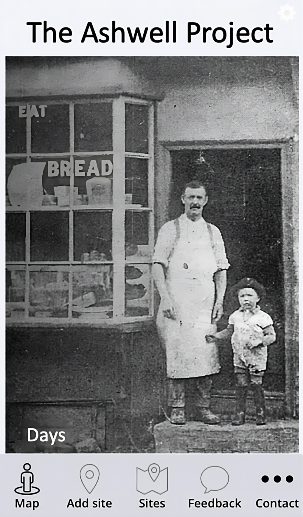
Figure 1: The home screen of The Ashwell Project. From here, users were able to quickly navigate to contents via a map to be able to navigate through the narratives, to add their own story, to see a list or map of all the different sites, to provide feedback on how to improve the app and to make with the author.
Figure 2: The Add Site form allowed users to add their own sites directly through the app. When submitted, it would send a notification to the author to check that the story was appropriate for public dissemination before release.
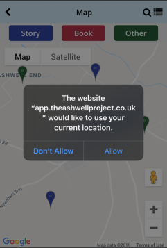
Figure 3: Users could choose to use their current location. It was then possible for the user to click on a pin and use their own native map system. The benefit of using the user's location meant that it was much easier to navigate from one narrative to the next.
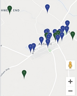
Figure 4: Map of sites (using data from Google Maps). Once a narrative was released either through the app itself or by upload by the author from the online or paper forms, it would add a new pin and send a notification to the users.
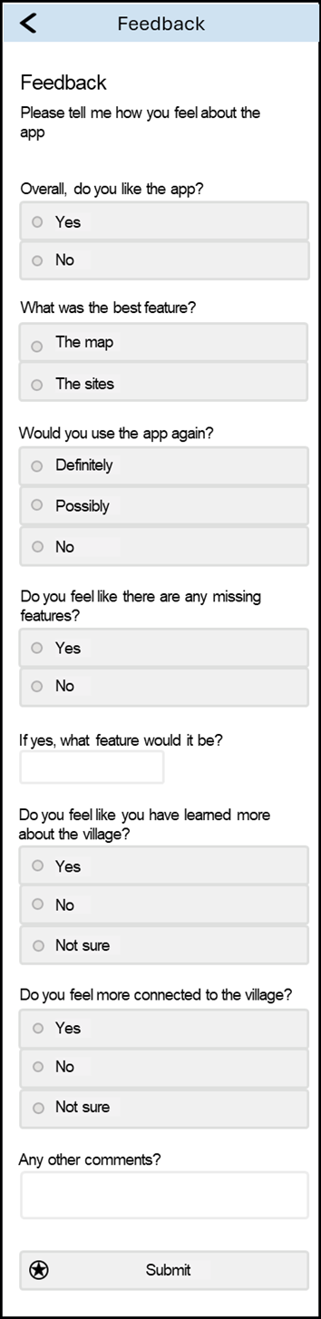
Figure 5: Feedback feature in the app. This short form was sent to the author to aid redesign or add new features enabling the project to be iterative and co-designed with the public.
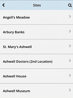
Figure 6: Part of the list of locally important sites. From this list, once a user clicked on a story, it opened a window e.g. Figure 7 or Figure 8. By providing sites in a list, it allowed users to quickly identify stories.
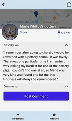
Figure 7: Marie Whitby's pottery. Depicting stories available through TAP (The Ashwell Project). The page commences with the location to precisely indicate where the site is situated within Ashwell, accompanied by a thumbnail image to provide visual representation. The title serves to identify the story with a description (narrative) furnished by the participant. A 'post comment' feature facilitated dialogue within the user community, though regrettably it remained unutilised. Directions were included to enable the user to navigate directly to the site. The website link provided instant access to the Ashwell Museum's listing of the site concerned.
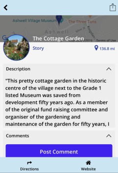
Figure 8: The Cottage Garden. Depicting stories available through TAP (The Ashwell Project). The page commences with the location to precisely indicate where the site is situated within Ashwell, accompanied by a thumbnail image to provide visual representation. The title serves to identify the story with a description (narrative) furnished by the participant. A 'post comment' feature facilitated dialogue within the user community, though regrettably it remained unutilised. Directions were included to enable the user to navigate directly to the site. The website link provided instant access to the Ashwell Museum's listing of the site concerned.
Alibhai, K. 2018 Social Isolation and Technology: How Technology Can be Used to Reduce Social Isolation Among Older Adults in British-Columbia, Social Connectedness Fellowship Program, Montreal: Samuel Centre for Social Connectedness. https://www.socialconnectedness.org/wp-content/uploads/2019/10/Social-Isolation-and-Technology-How-Technology-Can-be-Used-to-Reduce-Social-Isolation-Among-Older-Adults-in-British-Columbia.pdf
Baecker, R., Sellen, K., Crosskey, S., Boscart, V. and Neves, B.B. 2014 'Technology to Reduce Social Isolation and Loneliness' in Proceedings of the 16th International ACM SIGACCESS Conference on Computers and Accessibility, Toronto: Technologies for Aging Gracefully Lab (TAGlab). 27-34. https://doi.org/10.1145/2661334.2661375
Brown, T. 2008 'Design thinking, Harvard Business Review 86(6), 84. https://hbr.org/2008/06/design-thinking
Conolly, J. and Lake, M. 2006 Geographical Information Systems in Archaeology, New York: Cambridge University Press. https://doi.org/10.1017/CBO9780511807459
Cullum, A., Jarvis, P. and Unitt, C. 2020 Layers of London: Mapping the Journey Evaluation Report. London: Anna Cullum Associates. https://client-files.humap.site/layers-of-london/Layers-Evaluation-Report-4_FINAL-ISSUED-300920.pdf
Du, J. T., Peters, S., Haines, J., Trevorrow, A. E., Jia, R. M. and Ziaian, T. 2022 'A Framework for Co‐designing and Developing Participatory Storymaps with Aboriginal Communities', Proceedings of the Association for Information Science and Technology 59(1), 420-425. https://doi.org/10.1002/pra2.645
Elwood, S. 2006 'Critical issues in participatory GIS: Deconstructions, reconstructions, and new research directions', Transactions in GIS 10(5), 693-708. https://doi.org/10.1111/j.1467-9671.2006.01023.x
Eve, S. 2017 'The Embodied GIS. Using Mixed Reality to explore multi-sensory archaeological landscapes', Internet Archaeology 2(44), 124. https://doi.org/10.11141/ia.44.3
Goussios, D. and Faraslis, I. 2022 'Integrated Remote Sensing and 3D GIS Methodology to Strengthen Public Participation and Identify Cultural Resources', Land 11(10), 1657. https://doi.org/10.3390/land11101657
Greef, A. 2015 'A Late Neolithic Henge at Ashwell: Post-excavation Assessment and Updated Project Design', Oxford Archaeology East Report Number 1780. https://eprints.oxfordarchaeology.com/2940/
Hume, D. 2017 Progressive Web Apps, New York: Manning.
Jackson, R. and Burleigh, G. 2018 Dea Senuna: Treasure, Cult and Ritual at Ashwell, Hertfordshire, London: The British Museum.
Jeater, M. 2012 'Smartphones and site interpretation: the Museum of London’s Street Museum Applications' in C. Bonacchi (ed) Archaeology and Digital Communication: Towards Strategies of Public Engagement, London: Archetype Publications. 66-82.
Karki, A. 2019 'Progressive Web Applications (PWAs): powerful websites, functional as native mobile apps', Undergraduate thesis, Turku University of Applied Sciences. https://urn.fi/URN:NBN:fi:amk-2019060514940
Koukopoulos, Z. and Koukopoulos, D. 2018 'Evaluating the usability and the personal and social acceptance of a participatory digital platform for cultural heritage', Heritage 2(1), 1-26. https://doi.org/10.3390/heritage2010001
Larson, E. B. and Wang, L. 2004 'Exercise, aging, and Alzheimer disease', Alzheimer Disease and Associated Disorders 18(2), 54-56. https://doi.org/10.1097/01.wad.0000126615.70030.70
Larson, E. B., Wang, L., Bowen, J. D., McCormick, W. C., Teri, L., Crane, P. and Kukull, W. 2006 'Exercise is associated with reduced risk for incident dementia among persons 65 years of age and older', Annals of Internal Medicine 144(2), 73-81. https://doi.org/10.7326/0003-4819-144-2-200601170-00004
Lien-Talks, A. 2024 The Ashwell Project - data (Version 2) [Data set], Zenodo. https://doi.org/10.5281/zenodo.10726257
Lo Presti, O. and Carli, M. R. 2023 'Promoting Underground Cultural Heritage through Sustainable Practices: A Design Thinking and Audience Development Approach', Sustainability 15(11), 9125. https://doi.org/10.3390/su15119125
Morgan, C. and Eve, S. 2012 'DIY and digital archaeology: what are you doing to participate?', World Archaeology 44(4), 521-537. https://doi.org/10.1080/00438243.2012.741810
Mulholland, P. and Collins, T. 2002 'Using digital narratives to support the collaborative learning and exploration of cultural heritage' in Proceedings of the 13th International Workshop on Database and Expert Systems Applications, IEEE. 527-531. https://doi.org/10.1109/DEXA.2002.1045951
North Herts Council 2023 'Ashwell Conservation Area Character Appraisal and Management Plan'. https://democracy.north-herts.gov.uk/documents/s22416/Ashwell%20-%20Appendix%20B%20-%20Final%20Version%20CAAMP%2027062023%20Cabinet%20Draft%20Agenda.pdf [last accessed 04/02/2024].
O'Sullivan, D. 2006 'Geographical information science: Critical GIS', Progress in Human Geography 30(6), 783-791. https://doi.org/10.1177/0309132506071528
Pande, N., Somani, A., Samal, S.P. and Kakkirala, V. 2018. 'Enhanced web application and browsing performance through service-worker infusion framework', Proceedings of the 2018 IEEE International Conference on Web Services (ICWS), San Francisco: IEEE, 195-202. https://doi.org/10.1109/ICWS.2018.00032
Pavlovskaya, M. 2006 'Theorizing with GIS: a tool for critical geographies?', Environment and Planning A 38(11), 2003-2020. https://doi.org/10.1068/a37326
Philip, T. M., Schuler-Brown, S. and Way, W. 2013 'A Framework for Learning About Big Data with Mobile Technologies for Democratic Participation: Possibilities, Limitations, and Unanticipated Obstacles', Technology, Knowledge and Learning 18(3), 103-120. https://doi.org/10.1007/s10758-013-9202-4
Richardson, L.J. 2014 Public Archaeology in a Digital Age, Doctoral thesis, UCL (University College London). https://discovery.ucl.ac.uk/id/eprint/1436367/
Said, J. and Schleppenbach, D. 2004 Accessible user interface and navigation system and method, US Patent. https://patents.google.com/patent/US20040218451A1/en
Santos, B., Gonçalves, J., Martins, A.M., Pérez-Cano, M.T., Mosquera-Adell, E., Dimelli, D., Lagarias, A. and Almeida, P.G. 2021 'GIS in architectural teaching and research: planning and Heritage', Education Sciences 11(6). https://doi.org/10.3390/educsci11060307
Shih, P. C., Han, K. and Carroll, J. M. 2015 'Engaging community members with digitally curated social media content at an arts festival' in Proceedings of the 2015 Digital Heritage International Congress, IEEE. 321-324. https://doi.org/10.1109/DigitalHeritage.2015.7413892
Slavec, A., Sajinčič, N. and Starman, V. 2021 'Use of smartphone cameras and other applications while traveling to sustain outdoor cultural heritage', Sustainability 13(13), 7312. https://doi.org/10.3390/su13137312
Smith, R. 2009 'Finding the 'First Voice' in rural England: the challenges of safeguarding intangible heritage in a national museum', International Journal of Intangible Heritage 4(1), 13-25. https://www.ijih.org/retrieve/volumeDtl/44
Streich, L. 2017 For the Love of Maps: Know Your Place West of England. Evaluation - Final Report. Bristol: Rowan Associates South West. https://www.kypwest.org.uk/wp-content/uploads/2015/12/KYP-Evaluation-Final-Report.pdf
Tallon, L. 2008 'Introduction: Mobile, Digital and Personal' in L. Tallon and K. Walker (eds) Digital Technologies and the Museum Experience: Handheld Guides and Other Media, AltaMira Press. xiii-xxv.
The Ashwell Project 2020 The Ashwell Project, University of York and Ashwell Museum. https://theashwellproject.alfietalks.com/
Thomas, J. 2008 'On the Ocularcentrism of Archaeology' in V. Jorge and J. Thomas (eds) Archaeology And The Politics of Vision In A Post-Modern Context, Cambridge Scholars Publishing. 1-12.
Tripathi, N. and Bhattarya, S. 2004 'Integrating indigenous knowledge and GIS for participatory natural resource management: State-of-the-practice', The electronic journal of information systems in developing countries 17(1), 1-13. https://doi.org/10.1002/j.1681-4835.2004.tb00112.x
Van Dyke, R.M. 2014 'Phenomenology in archaeology' in C. Smith (ed) Encyclopedia of global archaeology, New York: Springer. 5909-5917. https://doi.org/10.1007/978-1-4419-0465-2_295
Internet Archaeology is an open access journal based in the Department of Archaeology, University of York. Except where otherwise noted, content from this work may be used under the terms of the Creative Commons Attribution 3.0 (CC BY) Unported licence, which permits unrestricted use, distribution, and reproduction in any medium, provided that attribution to the author(s), the title of the work, the Internet Archaeology journal and the relevant URL/DOI are given.
Terms and Conditions | Legal Statements | Privacy Policy | Cookies Policy | Citing Internet Archaeology
Internet Archaeology content is preserved for the long term with the Archaeology Data Service (ROR). Help sustain and support open access publication by donating to our Open Access Archaeology Fund.
 Home
Home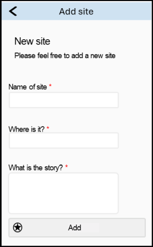